UPDATE: NOAA has corrected the typos in the illustrations at the new reanalysis intercomparison website.
# # # # #
NOAA opened two new blogs recently…and a new reanalysis intercomparison website, with a plethora of ENSO-related illustrations.
NOAA ENSO BLOG
I introduced the new NOAA ENSO blog at the end of the recent postThe 2014/15 El Niño – Part 10 – June 2014 Update – Still Waiting for the Feedbacks. With the length of that post, you may have missed it.
The new NOAA ENSO blog is hosted by Michelle L’Heureux and Emily Becker of the NOAA Climate Prediction Center (CPC) and Anthony Barnston of Columbia’s International Research Institute for Climate and Society (IRI). So far, the posts have been information-filled and geared toward readers without technical backgrounds.
Make sure you bookmark that new blog. Their next post is about the impacts of the evolving El Niño on U.S. weather this boreal winter.
NOAA HURRICANE BLOG
On May 29 this year, NOAA’s National Hurricane Center (NHC) published their introductory post at their new blog called the Inside the Eye. So far, that’s the only post. I look forward to their future posts.
NOAA REAL-TIME MULTIPLE REANALYSIS INTERCOMPARISON WEBSITE
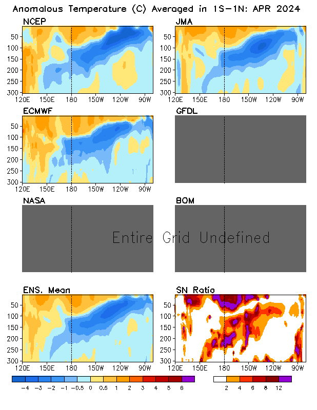
Back at the NOAA ENSO blog, Emily Becker introduced the new Real Time Multiple Ocean Reanalysis Intercomparison website in her June 5th post Details on the June 2014 ENSO discussion. They present the outputs of reanalysis models from NCEP, ECMWF , JMA , GFDL , NASA , BOM. Figure 1 is a sample illustration available from the new Real Time Multiple Ocean Reanalysis Intercomparison website. It shows the subsurface temperature anomalies for the equatorial Pacific (1S-1N) from those reanalyses. It can be found under the heading of SPATIAL MAPS and it’s identified as “Temperature anom. in 1S-1N (X-Z section): last month” there.

Figure 1
I’ve been using the similar pentadal (5-day) cross sections from the NCEP GODAS website for one my animations in my series of posts about the 2014/15 El Niño. (Latest example is here.)
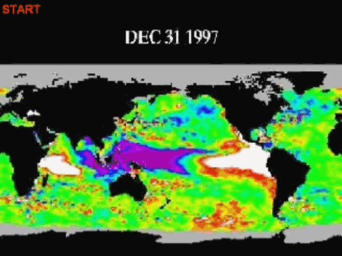
I’m looking forward to trying to use the “Temperature anom. in 5N-10N (X-Z section)” to capture the off-equatorial Rossby wave returning warm leftover warm water from the 2014/15 El Niño as it heads back to the west at the end of the El Niño. Example: we can see the Rossby wave in the 1998 off-equatorial (5N-10N) cross sections following the peak of the 1997/98 El Niño. See Animation 1.

Animation 1
In the past, one of the best ways I’ve been able to show that off-equatorial downwelling Rossby wave is with an animation of sea level residuals from JPL. (See the animation here.)
You may also find the y-z sections of the Pacific informative. Figure 2 is a view, looking to the west, of the subsurface temperature anomalies in the eastern tropical Pacific (120W-90W) for May 1997. The warm anomalies at depth on the equator are caused by the downwelling Kelvin wave that initiated the 1997/98 El Niño.

Figure 2
A year later, May 1998, in Figure 3, we can see the impact of the upwelling Kelvin wave (which ended the 1997/98 El Niño) on the equatorial Pacific, and we can also see the well-formed off-equatorial Rossby at about 5N-10N as its preparing to return the leftover warm water back to the western tropical Pacific.

Figure 3
Animations of those and other cross sections and the maps available from the Real Time Multiple Ocean Reanalysis Intercomparison website should be helpful for an upcoming post about the delayed-oscillator theory of ENSO. IRI used to have a relatively simple presentation of the delayed-oscillator theory but I can no longer find it at their website, after their recent changes there.
Wander around the Real Time Multiple Ocean Reanalysis Intercomparison website. There are numerous things there worth exploring.
NOTE TO THE NOAA REAL-TIME MULTIPLE REANALYSIS INTERCOMPARISON WEBSITE
Temperature is spelled wrong in many of the illustrations available from your website.
Other than that, thanks for a great teaching tool. I look forward to using it.
Regards
Bob
Haven’t read throught this yet but for what its worth the Trades are blowing a gale up the Queensland Coast today. The el Nino may be a way off yet.
luvthefacts on June 10, 2014 at 1:18 am
Haven’t read throught this yet but for what its worth the Trades are blowing a gale up the Queensland Coast today. The el Nino may be a way off yet.
An important observation. Dont hold your breath for an el Nino – the trades certainly are not doing so. Something is sustaining them – the “ground state” of the Pacific does not seem right for the boy child.
What I see is a 1972-73 el-nino like repeat. The sun and PDO are very close to the same now as then.
Focus should be on that 72-73 el-nino for ref instead of 97-98 one.
Circulation in the Pacific does not change. It also means cold fronts in the north west and storms in the central U.S..
http://earth.nullschool.net/#2014/06/14/0900Z/wind/isobaric/850hPa/orthographic=-117.25,4.03,419
I think it is a sorry state of affairs when when scientific evidence is dumped in favour of blog science. Since when are opinions a replacement for proper scientific research as epitomised by WUWT?
ren says: “Circulation in the Pacific does not change.”
That generalization is absurd.
Bob, is that modeled data being used or actual observations?
I must say it is concerning that they can’t spell.
That’s a classic Bob, They spell temperature wrong ha ha hahahahhhahahah lol
‘NOAH State of the art Wether Sisterm analsiususis’
Bob Tisdale says:
ren says: “Circulation in the Pacific does not change.”
That generalization is absurd.
You’re right. I’m not a scientist, just like you.
In case you missed it, here’s a NOAA hurricane blog that’s been going on for a while:
http://noaahrd.wordpress.com/
“Anamaleas Tempeature”
Hmmm?
ren says: “You’re right. I’m not a scientist, just like you.”
Another absurd statement. Your earlier statement contradicted decades of climate and oceanographic research. And it is contradicted by Southern Oscillation Index data, Sea Surface Temperature Data, Ocean Heat Content data, Sea Level data, Sea Level Pressure Data, Trade Wind Strength and Direction data, Ocean Current data, etc.
As opposed to looking at the weather model maps which give a very limited view, ren, try looking at data to support your hypotheses.
http://climexp.knmi.nl/selectfield_obs.cgi?someone@somewhere
Without data to support them, they are simply conjecture.
ossqss says: “Bob, is that modeled data being used or actual observations?”
They’re reanalyses, which are models that have data as inputs. TAO Project data for the equatorial Pacific (8S-9N, 135E-85W) have been available since the 1980s.
Cheers
Tom J says: “Anamaleas Tempeature”
I believe the first word is anomalous.
Mumbles McGuirck says: “In case you missed it, here’s a NOAA hurricane blog that’s been going on for a while: http://noaahrd.wordpress.com/”
Thanks, Mumbles. It’s curious that NOAA has two competing hurricane blogs. The one you linked (Hurricane Research Division):
http://noaahrd.wordpress.com/
And the one I linked (National Hurricane Center):
http://noaanhc.wordpress.com/
I understand they’re two different departments, but…
Regards
Bob,
How will NOAA’s approach be different than this?
http://www.climatecentral.org/
Why didn’t NOAA adopt or merge with ClimateCentral?
Does NOAA view ClimateCentral as problematic?
Bob Tisdale says:
June 10, 2014 at 7:41 am
Mumbles McGuirck says: “In case you missed it, here’s a NOAA hurricane blog that’s been going on for a while: http://noaahrd.wordpress.com/”
Thanks, Mumbles. It’s curious that NOAA has two competing hurricane blogs. The one you linked (Hurricane Research Division):
http://noaahrd.wordpress.com/
And the one I linked (National Hurricane Center):
http://noaanhc.wordpress.com/
I understand they’re two different departments, but…
Regards
———————————————————————————————
One is research the other operations. The two organizations have different goals, perspectives, and personnel. I don’t think there will be much overlap once NHC gets their blog going.
Bob Tisdale; thank you very much for the guidance. I am more Interested in the effects of data. Is the circulation the most important effect of El Niño, or not? Will there be a cooling of the Pacific far on north? I am convinced that the southern polar vortex will surprise us this year, as in previous. And this is related to the unusual magnetic activity of the sun. These phenomena interest me and that is what concentrate on. Of course, these are just suppositions. Thank you for your attention.
Bob Tisdale; Here you can see exactly BEGINNING winters in the south.
http://www.ospo.noaa.gov/data/atmosphere/radbud/gs19_prd.gif
Steve Oregon, since we’re seeing a lot of NOAA blogs popping up, it appears that someone issued a directive to department heads. ClimateCentral is of course an independent group.
That was quick. Once advised, NOAA corrected the typos…on every illustration I checked.
http://www.cpc.ncep.noaa.gov/products/GODAS/multiora/pac/teq/teq_pac_xz_L1.gif
When they can predict weather and climate, then maybe I’ll be interested. Right now it’s all entrails and tea leaves.