 Eric Worrall writes:
The volcano Mount Sangeang Api in the Lesser Sunda Islands has just erupted, sending a huge ash cloud 12 miles into the air.
Wikipedia describes Sangeang Api as a volcano complex with 2 active cones, Doro Api 1,949 metres (6,394 ft) and Doro Mantoi. 1,795 m (5,889 ft). Indonesia has a number of very active volcanoes, including volcanoes which threaten major cities, such as the infamous Mount Merapi.
Merapi, which has erupted several times in the last decade, is located just 17 miles from the city of Yogyakarta, home of 2.5 million people.
Near equatorial volcanoes like Sangeang Api are useful to global warming modellers, as the ash cloud can usually be detected in both hemispheres. They provide a convenient excuse for the short term cooling of the entire Earth.
Some spectacular pictures in the following link:-
Greg Goodman says:
May 31, 2014 at 9:37 am
Bill Inis: “Lower stratosphere temperatures appear to slowly recover over up to 25 years after a major stratospheric eruption. The idea is that Ozone is depleted by a the large eruptions and then it takes a long time for the Ozone to rebuild.”
Just fitted linear model to TLS from 1993.8 2013.8 : slope 1.6K/century
At that rate it will take over 300 years to recover the 0.5K it dropped after Pinatubo.
——————————————————————-
Maybe you should redo the math there. 30 years.
The lower stratosphere was as low as -0.5C around mid-1995 when the impact of Pinatubo wore off. It is now in the -0.2C range. In specific regions such as the tropics, monthly values are up into the positives – the Northern Hemisphere was positive in 2 of the last 4 months. I’m also going by what has happened in previous eruptions.
Will this volcano disrupt the stratosphere enough to cause a spike in stratospheric temperatures, followed by a downward step change as was observed in previous large eruptions? Then warmologists will claim the stratosphere is “cooling” due to increases of atmospheric CO2.
Well, it’s back.
The alarmists adjust the temperature up to compensate for the volcano.
Hello, Global Warming!
cn
Rudolph.A.Furtado you may need to make alternative trekking plans. Merapi may still have a exclusion zone around it. You can take the bus to the active Tangkuban Perahu – there’s a carpark right on the edge of the crater you can look down into the bottom of the crater without even getting out of the bus. Lusi is worth a visit. Bromo is spectacular – at dawn.
De Paus says:
I can give Ren this hyperlink about snow in the Atacama desert:
http://strangesounds.org/2014/05/the-driest-place-in-the-world-the-atacama-desert-in-chile-was-covered-with-snow-on-may-24-2014.html
Do you have eyes ?
http://earth.nullschool.net/#current/wind/isobaric/70hPa/orthographic=-88.84,-50.95,365
http://www.ospo.noaa.gov/data/atmosphere/radbud/gs19_prd.gif
Bill Innis:
Maybe you should redo the math there. 30 years.
The lower stratosphere was as low as -0.5C around mid-1995 when the impact of Pinatubo wore off. It is now in the -0.2C range. In specific regions such as the tropics, monthly values are up into the positives – the Northern Hemisphere was positive in 2 of the last 4 months. I’m also going by what has happened in previous eruptions.
=======
Oops. Thanks for catching that. It does seem more logical than a permanent down step. Climate always seems to recover in the end. BTW the trend I fitted was for tropical TLS that I’d used in my previous graphs.
But you still seem to want to take the last point on the graph and as the end of your arrow. There is, apparently random, short term variability that is about as large as the drop. Current values are at the top of that range. If you go back two years it was at a low point. Why are you using unrepresentative points to draw conclusions?
There is only one previous eruption where we had this kind of information, El Chinon. The small rise between when that settled out and when Mt P went up (only 5 or 6 years) is again mostly short term variability.
The only informative period is the long quiet one after Mt P. and the slow rise does seem to be in agreement with a slow recovery of ozone, as you suggested, or a new build of mainly chinese atmospheric pollution replacing the mainly western pollution that built up in the late 20th c.
However, it is a very slow recovery: 30 y from 1995 is 2025.
So in an odd sort of way this does seem to support recent suggestions that volcanism is a factor in “the pause”. Once that extra 2W/m2 of SW entering the lower climate system is recognised, the lack of major stratospheric events has contributed to the pause. The corollary is that it also made a significant contribution to the late 20th .c warming.
No I though I could not be that far out by eye. I’ve just checked the slope of tropical TLS from the annual peak at 1994.63 to the annual peak at 2013.63 . It’s what I originally said. :
m_lin = 0.00130434 +/- 0.005792 (444%)
c = 205.534 +/- 0.06168 (0.03001%)
383 years to recover at that rate.
Now if you want to disagree with that I suggest you do something more objective than cherry-pick the last two data points.
At the moment there are no indications of El Niño.
http://earth.nullschool.net/#2014/06/05/0300Z/wind/isobaric/850hPa/orthographic=-123.99,-12.78,553
Range of spray.
http://ozoneaq.gsfc.nasa.gov/omps/media/blog/images/OMPS_AI_indo_2014_05_31.png
Greg Goodman – very interesting stuff. It has been a pet theory of me for some time that Pinatubo’s long time effect may actually have been surface warming. The “signature” in lower stratospheric temperatures seems pretty obvious, but still the alarmists try to use it as proof of a causal link in the opposite direction!
The sudden change of temperature in the stratosphere has occurred in 2001 at the height of above 30 km.
http://www.cpc.ncep.noaa.gov/products/stratosphere/strat-trop/gif_files/time_pres_TEMP_ANOM_ALL_EQ_2001.gif
Things may be winding down. A search for VEI in Google News didn’t find anything.
From http://www.thejakartapost.com/news/2014/06/01/mt-sangeang-api-continues-erupt.html :
“Until Sunday morning, there were reports of volcanic tremors. Volcanic activity including gas and volcanic ash had also occurred, but this is now in decline,” the province’s Regional Disaster Mitigation Agency (BPBD) head, Wedha Magma Ardhi, told The Jakarta Post in Mataram on Sunday.
He said Sangeang’s declining volcanic activity could be seen from the smoke released on Sunday, which was less thick than on previous days. People in Wera village, Wera district, could also now see the volcano’s peak, which was previously obscured by smoke.
A disaster relief team dispatched by the NTB BPBD arrived in Wera district, Bima, on Saturday morning, to distribute masks, emergency tents and ready-to-eat food to locations prepared for evacuation.
Wedha said there had been no mass evacuation as the volcano was located on Sangeang Pulo island, around 10 kilometers from Bima’s mainland. Sangeang Pulo was also uninhabited.
It is reported that around 40 farming families from Wera district use lands on Sangeang Pulo for farming.
“They were all evacuated before the volcano erupted on Friday,” said Wedha.
He said people in three districts, namely Ambalawi, Sape and Wera, the three closest areas to the volcano, still needed a supply of masks and clean water. The Social Affairs Ministry and the National Disaster Mitigation Agency (BNPB) had also provided emergency assistance to those affected by the eruption.
What in the world are all of you people worried about? This is a small eruption from a relatively small volcano that historically has small eruptions ranging from VEI 1 to VEI 3. This eruption or should I say series of eruptions appear to be in line with previous historic events. So, unless this thing keeps putting up these large ash clouds every day or two for the next couple of months, we wont even notice it on a global scale.
Personally I would rather see it keep having these outbursts every other day for the next month or two. We are way over due for a really large eruption and I would much rather go ahead and get it out of the way in the relatively gentle way that this volcano has been doing, than to see an all at once VEI 7 eruption from someplace like Campi Flegrei or Long Valley. Though an event like that would be very cool to watch!
ren says:
The sudden change of temperature in the stratosphere has occurred in 2001 at the height of above 30 km.
http://www.cpc.ncep.noaa.gov/products/stratosphere/strat-trop/gif_files/time_pres_TEMP_ANOM_ALL_EQ_2001.gif
=====
Looks flakey. What is this radio sonde data ? It would be useful if you explained where some of these graphs come from. They’re not well enough labelled to be self-explanatory.
Your “Range of spray.” was interesting. Does not look like it be doing much appart from annoying aussie fliers.
Greg Goodman
Compare historical data.
http://www.cpc.ncep.noaa.gov/products/stratosphere/strat-trop/
http://www.cpc.ncep.noaa.gov/products/stratosphere/strat-trop/gif_files/time_pres_TEMP_MEAN_ALL_EQ_2001.gif
When Pinatubo blew up, that is the same year we had -40 F in upstate NY in March. And four feet of snow.
It was wicked cold not all the time but when it did get cold, it was very cold. Never seen it that cold before or since.
“Compare historical data.”
So what are we looking at ?! Is this model output , “reananlysis” , radio sonde? I still have no idea what these numbers are, Do you?
My guess is that this is “reanalysis” EOF type stuff from radio-sonde. That data is notoriously sparse and irregularly sampled. Looks like a sampling irregularity to me. What’s your point?
Greg Goodman look at this. Do you understand that the temperature in the stratosphere depends on the ionization?
Is a volcano erupted in the south the Pacific? Do you really not you see?
Those are not my data, but satellite information.
http://www.cpc.ncep.noaa.gov/products/stratosphere/strat_a_f/gif_files/gfs_t100_sh_f00.gif
Baronstone says:
June 1, 2014 at 5:05 am
“What in the world are all of you people worried about? This is a small eruption from a relatively small volcano that historically has small eruptions ranging from VEI 1 to VEI 3. This eruption or should I say series of eruptions appear to be in line with previous historic events. So, unless this thing keeps putting up these large ash clouds every day or two for the next couple of months, we wont even notice it on a global scale.”
It passed VEI-3 in about 2.5 hours just based on the initial vertical column height. Whether it the ability to make it to VEI-4 has yet to be seen. There was a lateral component to it during the initial phase, so that may have been the deciding factor. The initial blast was ejecting on the order of approximately 11279 m³/s DRE.
This may help in getting a handle on what the volcano was doing based on plume height.
“A multidisciplinary effort to assign realistic source parameters to models of volcanic
ash-cloud transport and dispersion during eruptions” Mastin et al (2009)
http://www.geo.mtu.edu/~raman/papers/MastinetalJVGR09.pdf
Note to my June 1, 2014 at 11:57 am.
Using VAAC alerts for the plume height input to the formulas in Mastin et al should be taken with a grain of salt. VAAC tend to over report since their goal is to keep pilots out of the ash cloud. If you do use them for your height values, only use those that are directly over the erupting vent. Do not forget to back out the edifice height or you will wind up over estimating the output rate.
ren says:
Greg Goodman look at this. Do you understand that the temperature in the stratosphere depends on the ionization?
Is a volcano erupted in the south the Pacific? Do you really not you see?
Those are not my data, but satellite information.
===
I never thought they were your data but where do you get that this is “satellite information.”?
What I see is “analysis” and I don’t see is the word “satellite”. I see what looks like a glitch in data, so before I spend too long scratching my head trying to work out which of the _many_ things affect str. temp. I want to know what I’m looking. at.
Since you don’t seem to know your self what you think I should be seeing as both ionisation and an unseen volcano, I’m rapidly losing interest.
“It passed VEI-3 in about 2.5 hours just based on the initial vertical column height. Whether it the ability to make it to VEI-4 has yet to be seen. ”
Thanks, Geo. I had not seen any VEI figures on this one yet.
Greg says: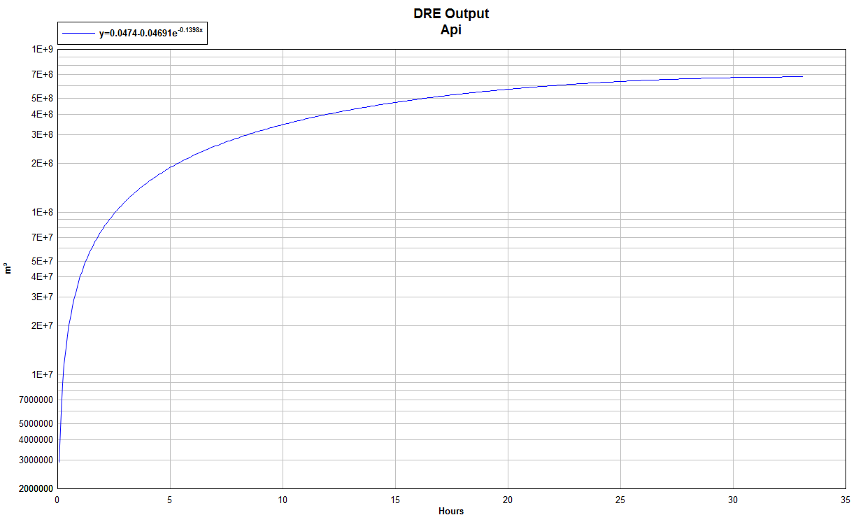
June 1, 2014 at 1:02 pm
…
“Thanks, Geo. I had not seen any VEI figures on this one yet.”
Nor have I. This is just an estimation based on available data. For previous eruptions that I have used this method on, it generally comes out reasonably close to what the official VEI is. The Mastin paper was intended for use on volcanoes with poor monitoring. In order to get a VEI, I take the known plume heights and find the rate at that time, then use a linear regression to infill the gaps in time at a per second rate, then integrate that.
This is a crappy run based off of only two data points, but seems to indicate that it may not make VEI-4. (it also doesn’t account for the lateral blast in the early part of the eruption).
Dr Behncke works for INGV at the Etna observatory, he has this to say about Api.
“From what I understand about this eruption, it’s almost identical to the 1985 eruption, which was a VEI 3. Only that back then we didn’t have all those spectacular images in real-time, and plume heights were not as easy to determine; yet the 1985 eruption column went presumably to 15 km and that’s what it has done this time, too. So I’d rather see this as a VEI 3 (upper range) or, at best, a low VEI 4.”