Satellite imagery of Colorado's High Park Fire

To hear and read the MSM reports about this fire, you’d think that the entire states of Colorado and Wyoming were ablaze. Meanwhile, the usual paid advocates are already wailing about how the fires are supposedly exacerbated by “climate change”. NASA has released MODIS imagery that puts the size of fire in perspective:

Colorado’s High Park Fire continues to expand and generate a lot of smoke visible on NASA satellite imagery. NASA’s Terra satellite showed winds from the west-southwest blowing the smoke to the north-northeast and into Wyoming and southwestern Nebraska on June 19th, 2012.

The High Park Fire is located approximately 15 miles west of Fort Collins, Colorado, and is now 55 percent contained. To date, 189 homes have been lost, according to the U.S. Forest Service. More than 1,900 people are currently battling the fire, and about 1.3 million gallons of water have been dropped on it. As of June 20, the fire has consumed 65,738 acres, up from the previous day’s total area of 59,500.

On June 19, 2012, at 1840 UTC (2:40 p.m. EDT) the light brown colored smoke and the heat signatures from the fires were detected by the Moderate Resolution Imaging Spectroradiometer (MODIS) instrument that flies onboard NASA’s Terra satellite.

Inciweb reports that pre-evacuation notices were issued to a number of areas. The U.S. Forest Service reported that fire was spotted “across the Poudre Canyon on the northwest corner of the fire triggered additional evacuations for the Glacier View subdivision and additional pre-evacuation notices west to Glen Echo Resort.” For a complete list of those areas and more information and firefighting updates, visit the Inciweb website: http://www.inciweb.org/incident/2904/.

For an unlabeled, high-resolution version of this image, visit: http://lance-modis.eosdis.nasa.gov/cgi-bin/imagery/single.cgi?image=Colorado.A2012171.1840.250m.jpg.

=============================================================

Some interesting stats from SOS Forests Western Institute for Study of the Environment:

The number of wildfires has been declining since the early 1980ā€™s. That may be an artifact of the counting system. Many small fires started by multiple lightning strikes in the same vicinity are counted as one fire today, while they may have been counted as many individual fires in prior decades.

Total Number of Wildfires, 1960-2009. Chart by W.I.S.E.

In addition, delays in rapid response to small fires may result in those fires merging, and then they are counted as one fire. That can happen to large fires that merge, as well. There are many name changes and mergers of fires during the fire season, which confounds the fire count. Wildfires donā€™t happen in test tubes in a laboratory, and so the counting system is not as accurate and precise as some scientific studies might lead you to believe.

Another possible explanation for the decreasing number of wildfires is that human-caused and/or lightning-ignited fires are fewer today than 30 years ago. We have no data to either support or refute those hypotheses.

The average size of wildfires in 2009 was 75 acres. That is more than 2008 (66 acres per wildfire), but less than 2005, 2006, and 2007 when the average wildfire size was 131 acres, 103 acres, and 113 acres per fire, respectively.

Average fire size is not a useful statistic, though, because the distribution (number of fires by acreage class) is skewed by a few very large fires (greater than 20,000 acres). The NIFC does not report the distribution, but it is more or less in a ā€œreverse-Jā€ (negative exponential) shape, with many small fires, fewer medium-sized fires, and a handful of megafires out in the tail. The average fire size is also dependent on the total count of wildfires, which may be biased by inaccuracies and imprecision in the counting system, as mentioned above. We present the following chart anyway, because we have the annual data and it was easy to make the graph.

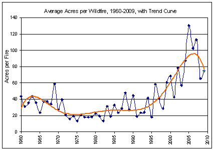
Annual Average Wildfire Size, 1960-2009. Chart by W.I.S.E.

0 0 votes
Article Rating
61 Comments
Oldest
Newest Most Voted
Inline Feedbacks
View all comments
Brian H
June 21, 2012 11:13 am

By my little eye-strapolation of the trend curve, there will be 0 fires in about 2017. Nirvana with choiring angels will thereupon descend upon the state.
Or maybe not.

Joshua
June 21, 2012 11:18 am

Wouldn’t a more important statistic be total number of acres burned per year?

Eric
June 21, 2012 11:19 am

Compared to the Cedar Fire or the Witch Creek Fire in San Diego…it is small potatoes…
http://en.wikipedia.org/wiki/Cedar_Fire
http://en.wikipedia.org/wiki/October_2007_California_wildfires#San_Diego_County

michaeljmcfadden
June 21, 2012 11:22 am

The note about paid advocates complaining that the fires are caused by “climate change” reminds me of Michael Crichton’s novel on the Warmers’ fanaticism and strategy: “State Of Fear.”
If anyone here has NOT read that, I would HIGHLY recommend it!
– MJM

June 21, 2012 11:23 am

The neighbouring states should sue for all the second-hand smoke.

R. Shearer
June 21, 2012 11:26 am

It’s unusual to have an early fire season that is this active. Interestingly, native Americans in Colorado used forrest fires as weapons and also to heard animals.

Stephen Wilde
June 21, 2012 11:36 am

Oh dear.
Flying off to US early tomorrow for a driving holiday in Colorado and Wyoming.
Don’t want to see ashes everywhere !!

June 21, 2012 11:38 am

As Steve Goddard pointed out in1898, Forest Fires Burned Most Of Northwestern Colorado, involving an area about 50 times larger than this present outbreak. If you want to see real big scale fires, come out to Australia in summer.

June 21, 2012 11:39 am

To give a little perspective, the following two images show what the smoke plume looked like locally, viewing the fire area from about 40 miles to the south east of the fire.
The first below is the actual smoke plume from the High Park fire on June 9 2012 as the fire was starting to develop rapidly from a small fire to cover approximately 800 acres.
http://blackhorsephoto.net/wild_fire/high_park_fire_smokeplume_early_12C_0022a_sm.jpg
The second image below is actually from a different fire the 4 mile canyon fire on 9/6/2010, but is visually very similar to the smoke plume of the High park fire on day two when it got to about 35,000 acre coverage.
http://blackhorsephoto.net/wild_fire/4_mile_canyon_fire_smoke_plume_DSC_0005.jpg
(photos copyright Larry Ledwick)
Fire suppression efforts included both water drops from multiple helicopters and in the early days of the fire they had 6 slurry bombers flying out of the Jeffco Air Tanker Base at Rocky Mountain Metro Airport (formerly named Jeffco airport) near Broomfield Colorado.
The entire front range near Denver is populated with fire species trees that evolved to deal with fire conditions and studies in the area just west of Denver show that these areas typically burn about every 75-80 years. Much of this area is over due for a large burn so the extent of the High Park fire is neither unusual or unexpected in the longer historical view.
Larry

Russ R.
June 21, 2012 11:43 am

I’m probably not the first to say this, but wildfires are natural part of the woodland ecosystem.
Yes, I’m fully in favour of actively fighting wildfires when they’re 1) caused by humans, or 2) a threat to life or property.
However, I’d allow naturally-caused fires to run their course, intervening only minimally when necessary to protect lives or property.
Decades of forest fire containment has led to greater accumulation of combustible debris on the forest floor.
So, yes… there may very well be a human cause for bigger and more intense forest fires, but I wouldn’t automatically pin the blame on global warming.

J. Knight
June 21, 2012 11:43 am

There are a couple of items that should be mentioned regarding these fires. First, the Obama Administration gutted the air tanker fleet, thereby assuring that these fires would be larger than they otherwise would be. And second, how did these fires get started? I haven’t heard, but it’s interesting to me that Islamic militants recently called for their adherents to set fires in the West as a way to attack the US. Does anyone know how these fires are getting started? Arson? Lightening? Accidental?

June 21, 2012 11:54 am

Show a time when climate didn’t change and there were no forest fires then I might pay attention.

June 21, 2012 11:56 am

Large-tree-burning fires are a recent development and are primarily caused by man (not climate change). Natural fires used to be frequent and burned rapidly and did not burn hotly because they consumed what once was relatively meagre forest brush and litter. The frequent fires produced an absence of fuel, fuel which is now abundant because of fewer fires that are rapidly controlled. The abundant fuel allows fires to burn long enough and hot enough at the trunks of trees to the point the fire reaches the forest canopy and a “crown” fire results, a fire that rages through tree tops creating its own powerful winds and spreading rapidly.
If you can’t allow small fires to burn away the brush and forest litter frequently, then the most cost-effective alternative is herds of goats and sheep. But fire does a better job.

June 21, 2012 12:28 pm

Using the number of acres burned per year might be a bit skewed, too.
Most firefighting used to be ground based till the mid to early 50’s. Then, airdrops of water made the containment easier, and helicopters were able to insert/extract crews closer to the center. Fires can be spotted earlier because of firetowers (which gained popularity in the early 1900s), and fire crews dispached quickly. Several states created fire roads to get crews in and out (and to provide firebreaks to act as a barrier to slow or stop the progress).
Satellite images like those shown above gained popularity. There are even programs that allow people to “model” fire events under varying conditions (check out here: http://www.firemodels.org/), and allow advance planning.
So as technology advanced, so did the fire detection and responses.

Olen
June 21, 2012 12:39 pm

The exaggerations of global warming crowd remind me of a movie part Jimmy Durante played as an army recruit. He dropped his 1903 Springfield rifle picked it up and told the drill Sgt. it was broke beyond repair.

MarkW
June 21, 2012 12:44 pm

Could the fact that we stopped automatically fighting all fires about 30 years ago have played a roll. The total amount of built up fuel has decreased over that time.

Dave Dodd
June 21, 2012 12:47 pm

@ majormike1 says:
June 21, 2012 at 11:56 am
DEAD ON! As a 40 year resident in a forest fire “bullseye” region (Northern Arizona), and having had to evacuate my house twice because of impending fires, I resoundingly concur. I was also a USGS employee, and worked with several forest management types who stated exactly as you have above. They refer to the modern forests as “doghair” growth, which literally has trees growing so close that a man cannot walk on the ground through them. Doghair growth also ushered in another phenomenon almost unheard of in older times, the “canopy fire” wherein the fire escapes the ground, flaming the explosive tops of the trees, producing a fire which generates its own wind and can travel 25-30 mph. Even water bombers can only circle overhead and wait for the fire to stall before attacking the edges. Cutting the bomber fleet certainly made that scenario even worse! Thanks Mr. Obama!
A corollary to the doghair problem is the increased spread of pine beetles, but that’s s whole different rant! Actually, pine beetles may be nature’s way of correcting man’s bungling!
I now live in Texas, learning to dodge tornadoes! Sheesh!

June 21, 2012 12:48 pm

Brian H says:
June 21, 2012 at 11:13 am
… Nirvana with choiring angels will thereupon descend upon the state.
What? The 1980s rock band?

BW
June 21, 2012 12:50 pm

Some perspective from someone who lives here…
Fires are not uncommon this time of year. Not every year normal, but not unheard of. But this was the driest winter in at least 20 years (after one of the snowiest last year when we had 200+%) There is no snowpack left. Also lots of beetle kill and waaaay more fuel than there would be if we allowed fires to burn rather than letting the forest grow out of control. This was not an if, but a when situation. Unfortunate for those who live in the area. I live in Denver. No smoke. Fire was started by lightning. Last one we had a few months ago was caused by the forest service lighting a “controlled” burn. People who lost homes were not happy.
Not the first, and surely not the last as there is a lot of fuel left in the mountains. However, contrary to what is often thrown out there, the beetle kill is natural and, though widespread and bad, not unprecedented. With or without AGW, this would still be happening. Poor forest management and the fact that more people live in these areas than in the past makes it seem much worse than it is.
Lastly, once “contained”, they are saying it will be fall before it fully burns out. Contained only means they will keep it from spreading further.
And to the guy coming here from overseas. You’ll be fine. Still plenty to see. You wouldn’t have gone there anyway. Drive through the smoke and move on and enjoy.

David Larsen
June 21, 2012 12:51 pm

Cleaning the forests is a natural process that has been going on for millions of years. The insects kill the trees so they are receptive to burning and a new process begins all over again. It is a revitalization of the natural habitat with a natural process. It is called homeostatis and everything comes back stronger and better the next time around.

Chuck
June 21, 2012 12:58 pm

Aqua and Terra satellite imagery is available on a daily basis for the entire US. Resolution varies on the orbital positions of the satellites.
http://activefiremaps.fs.fed.us/imagery.php
I looked over the last several days and it appears they picked the image with the greatest amount go smoke.

ian
June 21, 2012 1:04 pm

From previous graphs we have fewer but larger fires. What about total area then? I think I interpreted this data correctly.
http://www.nifc.gov/fireInfo/fireInfo_stats_totalFires.html
http://i.imgur.com/2MlfN.png?1
Seems to have increased overall.

Justthinkin
June 21, 2012 1:18 pm

“MarkW says:
June 21, 2012 at 12:44 pm
Could the fact that we stopped automatically fighting all fires about 30 years ago have played a roll. The total amount of built up fuel has decreased over that time.”
Uhmmmmmmmm….methinks you have your facts 180 degrees out of phase there,Mark.
Could the fact that we started automatically fighting all fires about 30 years ago have played a roll. The total amount of built up fuel has increased dramatically over that time.
There. All fixed for ya.

MarkW
June 21, 2012 1:32 pm

Justthinkin says:
June 21, 2012 at 1:18 pm
Two points, we stopped fighting all fires automatically about 30 years ago, not started.
Secondly, the question was about a decrease in number and size of fires.
The act of no longer fighting all fires and letting them burn themselves out, should lead to less fuel on the ground so that over time, there would be fewer and smaller fires, once the over burden has burned off.

Gary Pearse
June 21, 2012 1:32 pm

I guess they won’t tell us how many Manhattan’s that is! Maybe it should be measured in tennis courts – the megalomediacs measure Greenland ice melt in olympic-sized swimming pools full.

Gail Combs
June 21, 2012 1:51 pm

Stephen Wilde says:
June 21, 2012 at 11:36 am
Oh dear.
Flying off to US early tomorrow for a driving holiday in Colorado and Wyoming.
Donā€™t want to see ashes everywhere !!
____________________________________
They are big states Steve so not to worry.
If you get the chance and change where you are going, Carlsbad Cavern New Mexico and The Caverns of Sonora Texas are really incredible especially Sonora. I have never seen the like of Sonora anywhere else during my active caving days.

michaeljmcfadden
June 21, 2012 1:53 pm

JustThinkin, I would have thought that MarkW might be correct. I’d thought that after the Yellowstone fire back 20 or 30 years ago that the whole philosophy of fire-fighting was rethought with respect to the realization that staving off low-burn fires only sets the stage for uber-killer huge fires.
HOWEVER… I think there’s also been a policy of always fighting fires that threaten homes. As more and more homes get built in forested areas then that will lead to more and more cultivation of the conditions that eventually lead to Yellowstone type fires. What needs to be done is passage of regulations stating that if you want to build a home in certain areas you have to accept the fact that the forest service will not put out surrounding fires and will not expend more than a stated, fairly minimal, amount of effort in preserving your property in the event of a surrounding fire.
– MJM

Eric in CO
June 21, 2012 1:55 pm

I am here in Denver and fires are NATURAL in Colorado. This one was lighting, and the reader worried about visiting, there is plenty to do and no ash in the way. You will smell smoke sometimes, but faint. Be ready for more fires in the future. The pine beatle has decimated the forests leaving so much fuel it is rediculous, but this is nature. After the fires, we will have beautiful aspen forests for a few decades only to be replaced by pine. In fact we probably need more fires. It is what happens, especially in the west.

June 21, 2012 1:58 pm

OT
Can you spot a sun spot ?
http://www.vukcevic.talktalk.net/img3.htm

Paul
June 21, 2012 2:10 pm

Eric,
You forgot to include the “Old Fire” which was burning at the same time as the Cedar fire for another 91,000 acres. The “Old Fire” merged with the “Padua,” and the “Grand Prix” wildfires to burn over 750,000 acres.
http://en.wikipedia.org/wiki/Old_Fire_%282003%29
The sad part of the Old Fire is the environmentalists had blocked forest thinning for years, prior to the old fire, that would have limited the fire. Global warming…. yeah right.

June 21, 2012 2:25 pm

I live three miles from the fire, and there is almost no smoke visible today. This fire is less than 1% of the size of the 1898 fire.
http://stevengoddard.wordpress.com/2012/06/15/the-fort-collins-2012-mega-fire/

DonS
June 21, 2012 2:47 pm

Forest management? We ain’t got no forest management. The forests are wholly owned by the ecomentalists and activist federal judges.

Stephen Wilde
June 21, 2012 3:04 pm

Thanks for the various reassurances.
If anyone has time to meet for a drink I’ll be at Leows Hotel Denver Tuesday to Thursday next week.
Going to sleep now ready for an early flight and probably off line for about 3 weeks.
Best wishes to all.

Lester Via
June 21, 2012 3:17 pm

I am always amazed that those calling themselves climate scientists actually believe that things, such as in this case, forest fire data, is compelling evidence of a warming climate when it is so difficult to determine the climate warming from data consisting of actual temperature measurements. To them, virtually every ecosystem in existence is more sensitive to climate changes than are our best analysis techniques using the chaotic weather data taken with temperature sensors.
Such papers seem to be, instead, compelling evidence of the incompetence of our leftist, higher educational system’s ability to produce scientists with logical reasoning powers. Presently, climate science seems more like a faith based religious cult with the fundamental belief that man is destroying the planet than a true science. Everything they see is interpreted as compelling evidence of climate change.

John A. Fleming
June 21, 2012 3:48 pm

Mountain towns, and people who build homes in forested areas, just hate to have that 100 foot no brush/trees buffer around them. What’s the point of moving to the cool shady forests if you are always in the bright high-altitude sun? And you can’t just tell the firefighters to let the homes burn, else it creates a moral hazard.
The only way to solve this, is to clear cut a 200-foot strip at the public/private lands boundary, 100 foot on each side. That way the public forest can just burn, and the private lands VFDs can put out any brush/grass fires that hop the boundary. And the public lands firefighters will not assist in suppressing fires that jump out of their boundary. If the private lands don’t want to clear-cut their side, well, that’s their problem, and the landowners can negotiate with their insurance agencies.
The private landowners should be under no illusions or implicit promises: the Feds will not save you from fires.
See what I’ve done? Public lands firefighting becomes fire management. Let the fires burn internally, fight at the borders.

Lester Via
June 21, 2012 4:02 pm

I didn’t make it clear in my previous post that my comments were directed at the link Anthony provided to “Connecting The Dots: How Climate Change Is Fueling Western Wildfire” when clicking on “wailing” at the beginning of his post.

Judy F.
June 21, 2012 4:28 pm

There has been plenty of smoke from the High Park fire in northeast Colorado and Western Nebraska. It has been hazy and the smoke smell has been very intense. We don’t have mountain fires to worry about here on the plains, but there are devastating, fast moving prairie fires like the one in March of this year that burned over 37 square miles. http://denver.cbslocal.com/2012/03/23/yuma-wildfire-downed-power-line/ One of the best pictures I have seen of the massiveness of a prairie is fire is this one: http://rammb.cira.colostate.edu/projects/npp/blog/index.php/uncategorized/i-and-m-band-views-of-the-heartstrong-fire/attachment/yuma-fire/
We have been incredibly dry this year, with only 4 inches of precipitation. Last Sunday, at a nearby weather reporting station, it was 104 F, with 6% humidity and over 20 mph winds. http://www.wunderground.com/history/airport/KSNY/2012/6/17/DailyHistory.html?req_city=Sidney&req_state=NE&req_statename=Nebraska With those kinds of numbers and the unceasing winds we have had lately, it is no wonder that everyone has been looking out their windows when we smell smoke.

DesertYote
June 21, 2012 4:55 pm

And lets not forget that there are those who set fires deliberately for political reasons some of who cry the loudest about the evils of man destroying the earrrth as exemplified by the radically increasing number of climate changed fires.

geran
June 21, 2012 5:08 pm

Out of control forest fires are tragic to locals, so I hesitate to be too satirical….
But to those warmers that try to link this to AGW, the fire was started by lightning. GAIA obviously knows the rain forest and oceans need more carbon dioxide!

Ian H
June 21, 2012 6:50 pm

The downwards “hook” on the end of your trendline for average fire size is a statistical endpoint effect. Truncating the data at various other endpoints will cause this “hook” to wave around erratically. Its shape therefore has almost no statistical significance. I know that you know this. All the statistically aware readers here know this. But sadly the average punter puts far greater significance on the shapes of ends of curves than is statistically warranted. If anyone reading this looked at the shape of that hook and thought “it peaked out and is heading down” then think again. The data actually allows us to draw no such conclusion.
Given that people are often mislead in this way, I would have preferred that you had either not shown the end portion of the trendline where it has very low statistical significance, or had omitted it altogether. Drawing data in a manner likely to deceive people into false conclusions is something the other side does all the time but which I would prefer we avoid.
I note that the hockeystick derives much of its psychological impact from this tendency of people to vastly overestimate the significance of the shape of the ends of curves in graphs.

George Lawson
June 22, 2012 3:24 am

It always amuses me how the proponents of the global warming scam continue to blame the large forest fires onto AGW, and seemingly ignore its effect on smaller fires. Forest fires are always started by the same single source of heat however created. It could be from a glass bottle magnifying the heat; camp fires left by careles travellers; discarded cigarette ends or arson. The size of the fire from thereon is determined totally by the degree by which the local fire services can get to that fire to extinguish it. If a fire has been burning for some time before the fire services are alerted, or accessibility is difficult for fire fighting vehicles and equipment then the fire has a greater chance of spreading rapidly and becoming out of control. It has nothing whatsoever to do with the degree that the effect of global warming has on that fire.

Laurie Bowen
June 22, 2012 7:34 am

Just got done re-reading “The Space Merchants” by Pohl and Kornbluth originally written in 1953!
http://en.wikipedia.org/wiki/The_Space_Merchants
I wonder if it is a ‘required reading’ M.O. case study. At least, for anyone wanting to pursue a ‘confidence game’!
A book that is timely, over and over again!
http://www.amazon.com/The-Space-Merchants-Frederik-Pohl/dp/1250000157#_

Larry Ledwick (hotrod)
June 22, 2012 9:56 am

More than half of the western half of the state is under a red flag warning today. Both today and tomorrow are projected to near the 100 deg F mark and humidity levels could drop to low double digit and even single digit humidity this afternoon with gusty winds. Ideal fire conditions but nothing new or unusual. This sort of summer weather happens every few years here. We are after all, near a desert climate, with annual precipitation typically being near 14-15 inches of precip a year, and in dry periods half that as an annual total is not unheard of.
Colorado is currently under a fire ban for open burning with few exceptions.
http://www.denverpost.com/breakingnews/ci_20858292/colorado-bans-open-burning-other-than-structured-campfires
http://forecast.weather.gov/wwamap/wwatxtget.php?cwa=bou&wwa=red%20flag%20warning

URGENT – FIRE WEATHER MESSAGE
NATIONAL WEATHER SERVICE DENVER CO
412 AM MDT FRI JUN 22 2012
…HOT…DRY…AND BREEZY CONDITIONS THIS AFTERNOON THROUGH
SATURDAY…
.HIGH PRESSURE WILL BRING HOT AND DRY AIR OVER COLORADO TODAY AND
SATURDAY. MEANWHILE A WEAK UPPER LEVEL DISTURBANCE PASSING NORTH
OF COLORADO WILL INCREASE THE WINDS TODAY. THIS COMBINATION WILL CREATE
VERY HIGH TO EXTREME FIRE DANGER IN AND NEAR THE NORTHERN COLORADO
MOUNTAINS. IT WILL REMAIN WARM AND DRY TONIGHT WITH POOR HUMIDITY
RECOVERY IN MANY MOUNTAIN AREAS. SATURDAY WILL SEE NEAR RECORD
HEAT WITH VERY LOW HUMIDITIES… ALTHOUGH WINDS ARE EXPECTED TO BE
LIGHTER.

* TIMING…THE GUSTY WINDS AND LOW HUMIDITY ARE EXPECTED TO
DEVELOP BY NOON TODAY. IT WILL REMAIN WARM WITH POOR HUMIDITY
RECOVERY AND BREEZY CONDITIONS IN MOST AREAS TONIGHT… THEN NEAR
RECORD HEAT IS EXPECTED WITH VERY LOW HUMIDITIES AGAIN ON
SATURDAY.
* WINDS…SOUTHWEST 15 TO 25 MPH WITH GUSTS UP TO 40 MPH.
* RELATIVE HUMIDITY…AS LOW AS 5 PERCENT.
* IMPACTS…THE INCREASING WINDS…COMBINED WITH THE WARM AND
DRY CONDITIONS COULD CREATE EXTREME FIRE BEHAVIOR ON ALREADY
EXISTING FIRES AND MAKE ANY NEW IGNITIONS DIFFICULT TO CONTROL
WITH POSSIBLE HIGH RATES OF SPREAD.

Larry

Jim
June 22, 2012 11:57 am

Nothing out of the ordinary there. Fires are a normal feature of the western ecosystem. The environmentalists should be rejoicing. The drought concerns are being overblown… Colorado is an arid climate.

June 22, 2012 9:27 pm

Dear Anthony,
Thank you for posting my fire graphs. Surprised me, but thank you anyway. They are a little out of date (2010 and 2011 missing).
So I have updated. You can see the latest graphs for Total Acres, Number of Fires, and Acres Per Fire (1960-2011) here:
http://westinstenv.org/sosf/2012/06/22/wuwt-cites-sosf-fire-graphs/
I apologize for not working diligently on the WISE websites for the last year or so. Been too busy with other stuff, such as
http://giveusourlandback.org
After awhile saying the same thing over and over got tiresome for me. I salute your efforts, Anthony. You are indefatigable. I got fatigued.
Re fire and climate, please note that average temperature has been decreasing in North America over the last 15 to 25 years, while forest fire severity, frequency, and extent have been increasing. The two are not correlated, or are at best inversely correlated (poorly). Hence the hypothesis that increasing temperatures cause increasing fire severity, frequency, and extent is disproved.
There is no question that fire acreage, count, and average size are driven in part by weather. Dry lightning followed by big winds is bad news for forests. In Northern California a dry lightning storm swept across the state on June 21, 2007, setting ~2,000 fires, some of which burned until the following fall with over a million acres incinerated.
But weather is not the only factor. Forest policies that allow fuel to accumulate and that ignore fuel continuities are to blame for increasing fire size and total acres burned.
Plants grow every year, and biomass accumulates every year. Without human stewardship the trend is unwaveringly upward. Biomass loadings in our forests today are 5 to 10 times what they were 200 years ago. Biomass is the stuff that burns in forest fires. Biomass accumulation and continuity across the landscape are important (highly significant) determinants of fire intensity and areal extent.
Also, beginning in 1988, Federal land management agencies adopted a policy of Let It Burn on many fires. That policy has led to numerous catastrophic megafires. If you halt management, and if you let fires burn, they will, and they have.
Some folks blame the homeowners for failing to address the fuels in their vicinities. There is some truth to that. What homeowners need to do is to INSIST that federal and state agencies manage public lands so that firestorms to not emanate therefrom.
Reduce the fuels; establish fuel discontinuities. Anything less is asking for trouble.

Common Sense
June 22, 2012 10:56 pm

“Itā€™s unusual to have an early fire season that is this active”
Not here in Colorado. Our fire season usually starts in May, sometimes earlier, depending on the weather. If it’s going to hit 100 degrees, it’s usually during the 3rd week of June, just like if it’s going to hit 20 below, it will be during the 3rd week of January.
Maybe the number of fires has decreased, but at least here, the size of the fires has increased. In 1996, the Buffalo Creek Fire burned 12,000 acres in one day, the winds were 60 mph and you can still see the blowtorch pattern from the air. It was the largest fire in recorded CO history. Since then we’ve had 12 fires much larger, as you can see from this list:
“Since 2000, Colorado has averaged nearly 2,000 wildfires per year and sees an average of more than 95,000 acres blackened by blazes. Most of these are quickly contained and little damage is seen but some turn into massive fires or quickly rip through areas where population has encroached.”
Largest wildfires in Colorado history (acres burned):
2002 Hayman Fire, southwest of Denver – 137,760 acres; 5 deaths, 16 injuries, 600 structures
2002 Missionary Ridge Fire, near Durango – 71,739 acres; 1 death, 52 injuries, 56 structures
2012 High Park Fire, Larimer County – 68,200 acres (active); 1 death, 200+ structures
2002 Spring & Fisher/James John fires (Trinidad Complex) – 32,896 acres; 6 injuries
2002 Burn Canyon Fire , Norwood area – 31,616 acres; 9 injuries
2002 Mount Zirkel Complex, Steamboat Springs area – 31,016 acres
2012 Heartstrong Fire , Yuma County – 24,000 acres; 3 injuries, 2+ structures
2000 Bircher Fire , Mesa Verde area – 19,709 acres
2002 Big Fish Fire , Steamboat Springs area – 17,056 acres; 8 structures
2012 Little Sand Fire, Pagosa Springs area – 15,987 acres (active)
2002 Spring Creek Fire , New Castle area – 13,490 acres, No structures
2002 Coal Seam Fire , Glenwood Springs area – 12,209 acres; 113 structures
1996 Buffalo Creek Fire , Jefferson County – 12,000 acres; 10 structures
2000 Hi Meadow Fire, Bailey area – 10,800 acres; 51 structures
2000 Bobcat Fire, Larimer County – 10,599 acres; 18 structures
2002 Million Fire, South Fork area – 9,346 acres; 11 structures
2012 Hewlett Fire, Ft. Collins area – 7,685 acres
2010 Fourmile Canyon Fire, Boulder area – 6,388 acres; 174+ structures
2012 Sunrise Mine Fire, Gateway area – 5,742 acres; 2 injuries
2000 Pony Fire, Mesa Verde area – 5,250 acres; 4 structures
2002 Bear Fire , Dinosaur National Monument area – 4,800 acres
2002 Iron Mountain Fire , Canon City area – 4,436 acres; 200+ structures, 3 injuries
2002 Big Elk Fire, Estes Park area – 4,413 acres; 3 deaths, 1 structure
2012 Lower North Fork Fire, Conifer area – 4,140 acres; 3 deaths, 23+ structures
2002 Schoonover Fire, Douglas County – 3,860 acres; 13 structures
1990 Olde Stage Fire , Boulder County – 3,000 acres; 10 structures
2010 Crystal Fire, Larimer County – 2,940 acres; 13 structures
2002 Snaking Fire , Bailey area – 2,590 acres; 2 structures
1994 South Canyon Fire (Storm King Mountain) – 2,115 acres; 14 deaths
1989 Black Tiger Gulch Fire – 1,778 acres; 44 structures
Most of these fires are in what’s called ‘The Red Zone’, basically the drier foothill areas of the state. The Buffalo Creek Fire, Hi Meadow, Hayman, Lower North Fork, and the Snaking Fire are all within a few miles of each other, about 30 miles southwest of Denver. All of the Larimer County, Ft Collins, and Boulder fires are also in the same kind of locations. 2002 was a particularly bad year. The Red Zone is a popular place to live since it’s close to the larger cities so that you can live in the mountains and still have an easy commute. People who do so, especially if they come from out of state, are not always aware of the risks.
This morning we could smell smoke from the High Park Fire in Arvada, about 60 miles directly south of Ft Collins. We’re fortunate that most of the big fires seem to happen north or south of us so we don’t get smoked as badly as some other areas.
We lost our family cabins in the Buffalo Creek Fire and one man died in the resulting floods when his truck was swept away. The flooding was just as devastating since the hot fire bakes the ground and water can’t penetrate. We had what we call “gully washers” shortly after the fire that left banks of gravel 7 ft tall on the bends of the creek, a creek that’s normally a foot deep and maybe 10 ft wide. Since we’re such an arid area, it will take hundreds of years for the forest to come back. We’ve since rebuilt (a log home with a metal roof this time), but are surrounded by daily reminders. In fact, we’re doing fire mitigation this weekend. Although most of the trees are gone, there is now a lot of grass, and as someone else mentioned, grass fires can be just as destructive.
Firefighters can do little to stop a fire that’s blowing 60 mph and tossing embers miles in front of it. Sometimes they can foam a house, if they have enough time, but they usually need Mother Nature to step in with a weather change before it gets under control. Our places were gone before firefighters were even notified. One smoke jumper said that the fire was so hot, the cabin would have burned even if it had been in the middle of the creek, and we were on the edge of the fire.
It’s a horrifying experience and unfortunately, it doesn’t seem like things are going to let up until all of the areas with a lot of fuel buildup are burned.

Common Sense
June 22, 2012 11:07 pm

A couple of other points… the humidity today was 8% and the Buffalo Creek Fire was caused by students from an alternative high school who were camping on their teacher’s property. They were unsupervised and started a campfire that started to spread, then didn’t report it.
Hayman was started by a disturbed forest employee, the Snaking Fire by high school students smoking behind the school, the Four Mile Canyon Fire was started by a volunteer firefighter who burned debris in a fire pit several days before and the wind reignited the embers. Yes, lightning starts a lot of them, but many are caused by irresponsible humans. Don’t throw cigarette butts out the car window, don’t burn ANYTHING when the wind is blowing, and always put out a camp fire with both dirt and water.

June 22, 2012 11:32 pm

Excellent comments by Common Sense.
One factor to consider, though, is that burning all the areas with fuel buildup will not suffice to prevent future fires. The reason is that fuels are biological; they are plant growth. The production of biomass cannot be stopped, even if we wanted to.
All of today’s fires are reburns of areas that have burned many times in the past. One-time burns do not reduce fuels all that much, and in green areas fires often increase the amount of dead, dried fuel. But mainly the plants grow back and resume adding biomass to the ecosystem. Fire hazard returns in as little as 5 years in highly productive areas.
It is often claimed that fire suppression causes bigger fires later. That’s not true. Biology causes fires, with or without suppression.
Relentless control of biomass is required, because biological production is relentless. The Indians knew that and burned landscapes frequently in early spring or fall. They understood that untended landscapes would eventually blow up into catastrophic fires that could threaten their very survival.
Nothing has changed, except that moderns have forgotten the basics of life and living in fire-prone areas. The take-home lesson is that untended landscapes are deadly.

Reply to  Mike Dubrasich
June 23, 2012 8:43 am

Untended landscapes are what sheep and goats are for. Even on The Sea Ranch, on the Northern California coast, where it seemed they have always resisted doing anything sensible, finally woke up and now has a shepherd with temporary fencing moving his (actually her) flock constantly throughout the brushy areas.

Laurie Bowen
June 23, 2012 7:47 am

@michaeljmcfadden says:
June 21, 2012 at 11:22 am
Re: Michael Crichtonā€™s novel ā€œState Of Fear.ā€
http://en.wikipedia.org/wiki/State_of_Fear
How does wiki do on this article, is it an accurate synopsis?
Thankyou for the recommendation.

michaeljmcfadden
Reply to  Laurie Bowen
June 23, 2012 10:27 am

Laurie, while the Wiki synopsis lacks the impact of sitting back and enjoying the whole novel, it *does* seem to offer a pretty reasonable and balanced summary! :> It doesn’t do quite as well as Crichton in conveying the degree of cold-hearted “ends justify the means” villainy that we actually see among some of the driving activists in movements like global warming and anti smoking, but it does summarize the plot elements and characters pretty well.
What impressed me about it was the degree of basic scientific backup argument Crichton offered, the clarity of the basic graphs etc that he used to buttress the arguments of his main protagonist, the usual high-quality of his novel as a novel, and his stance on the issue while not likely being “in the pocket” of BigOil or BigCoal or BigWhatever. I’d say that personally, before reading Crichton’s book, I would have tended to be moderately on the side of the Warmers. After the book I moved at least moderately to the side of the folks here.
From being so involved with the smoking scam issue I’ve become quite aware of how easy it is to juggle science and also how subtle the influence of MSM media coverage is in shaping our basic attitudes thoughts on such issues in ways that we’re not even aware of. Crichton alerted me to how similar mechanisms were being used by the Warmers, and, although I haven’t done nearly enough research in this area to be as comfortable in my position as I am on the smoking ban type issues, I’ve ended up being far more in the skeptics camp than in the Warmers camp. Heh, I wish I had Crichton’s skill in fiction: I would have written Dissecting Antismokers’ Brains as a novel, sold a million copies, and maybe have had an even more significant impact! LOL!
– MJM

June 23, 2012 9:37 am

Domestic grazers (sheep, goats, cattle, horses) and putative “wild” grazers (deer, elk, antelope, etc.) can recycle biomass to some degree, and even overgraze areas. But coniferous forests are largely impervious to grazers and browsers.
Our vast public forests are where the worst fires arise. They need human tending with technologies such as chainsaws, skidders, and prescribed fire in stands people have prepared to receive fire.
Traditional forests on this continent and others were human tended with selective burning of patches and individual trees. That gave rise to anthropogenic mosaics of berry fields, root crop prairies, fiber farms, and nut and fruit orchards.
The open and parklike ponderosa and pinyon pine forests of Colorado were deliberate nut orchards maintained for thousands of years by man. Trees were widely separated so that the frequent anthropogenic fires and less frequent lightning fires did not carry from crown to crown. Today we mow our orchards. Then set fire was used to keep the ground between trees free of brush and thickets of young trees. In both case the goal was and is to protect the sources of food and fiber.
We moderns have philosophically and practically separated ourselves from “nature”. We have entrusted high priests of “science” to theologize a toxic relationship: humans as pathogens and nature as a vengeful goddess. That’s one reason purveyors of climate alarmism can gain traction with their a-scientific Chicken Little-ism. People have been taught from childhood to accept such nonsense.
But the fact is that humans, by biological imperative, are the caretakers of nature. We cannot divorce ourselves from nature any more than we can divorce our own bodies. We have to tend our landscapes or they and we will suffer fatal consequences.

Laurie Bowen
June 23, 2012 11:06 am

– MJM
Thank you for that! Many don’t like people citing wiki’s site, but, I think it probably get’s more right than it does wrong, so an added thanks for vetting it . I hope you rated the page as only 5 people have.

michaeljmcfadden
Reply to  Laurie Bowen
June 23, 2012 12:52 pm

Laurie, thank you for the tip on the ratings. I gave it 5 stars across the board. I also however found an interesting criticism of it at:
http://climateprediction.net/science/pubs/nature_StateOfFear.pdf
which folks might like to read and react to, though we’re straying a bit from the original CO fire topic???
– MJM

pk
June 23, 2012 11:17 am

there are some things that we need pointed out:
(based on an early life in western montana)
first the statistics lie like a rug. the feds count every fire that they become aware of. there are a terriffic number of fires that are anywhere from dinner plate sized (they smolder for about a week or so and then the aircraft spot the smoke for about three days running and they send a couple of guys out to it and those guys put it out with the urination technique).
then there are the big ones that can run up to a million acres. supression techniques on those as a practical matter run from speculation on whether its going to jump the river or shall we pray for early snow.
thats really big country out there. there are counties that have 392,000 acres in the public domain and that is 92% of the county with a county population of about 800 souls. (and there’s five more of those to the west before you get to idaho).
as far as the cause of a fire, the following questions should be asked. did the fire start near a road or a garbage dump? if so its probably man caused. if it started 90 miles from civilization then its probably lightning caused. most of them no matter what the greenies say to the news papers say are lightning caused. the majority of fires happen in the late summer towards the end of august when the ground has had time to dry out the brush and bushes and other stuff.
back in the day USFS used to sell the timber (under strict control) to the lumber mills. as a part of the sale they required a considerable milage of roads to be built which turned out to be very efficient fire breaks. part of the sale profits went to reforestation. that is planting pine trees (about six inches long with one branch) by the hundreds of thousands. they started that during the 1930’s and are still doing it. the trees that i planted during the 1960’s were cut down and turned into houses in bakersfield ca in the 1990’s.
And for the greenies that want to scream “you didn’t cut down a tree did you, how terrible!!!!!” i will remind them that they mow their lawns don’t they. its just a different crop and growing cycle.
C

pk
June 23, 2012 11:29 am

Common Sense says:
June 22, 2012 at 10:56 pm
quite a number of years ago ~20 they had a fire in montana that went past 280,000 acres with a whoop and a hollar. i looked on google to see if the home town was burned to the ground and the closest that one was was one mountain ridge to the east.
in 1910 there was a fire that started about 20 miles east of the montana idaho line and went almost to wallace idaho (or so they say) it was called the 1910 burn. in 1960 you could see the remains of it on the mountainsides. it looked like a lawn with about one huge tree per acre sticking up out of it. when you got up into it, the “lawn” was pine about 30″ through the butt. the trees sticking up above the lawn were all “lightining rods” and we had about two fires a week from the middle of august until the first snow in that area.
C

pk
June 23, 2012 11:47 am

there is something that anthony and the gang should be interested in.
during the sixties (and i think that it is still in practice) every forest service station, lookout tower and wide place in the road had a “weather station”. it was a small area that was fenced in out in the forest with the “instruments” in a little classic white “house” on about a 3′ stand. inside the house was a barometer, a thermometer a wet bulb thermometer and a couple of other things. on the ground was the important instrument, to them, was a set of precision “sticks” that they very carefully weighed with a very precision scale inside of the house. there were two sets of sticks one on the ground itself and the other on a wire stand about 8″ off the ground. the difference in weights gave them the “forest floor fuel moisture content”. they wrote all of that stuff down on a chart and sent the charts to the main offices in courdelane. as far as i could tell this stuff was all over the united states and there might be a huge pile of data somewhere.
C

Laurie Bowen
June 23, 2012 12:15 pm

It’s my understanding that is was these “Great Fires” that led to ‘innovative’ new building materials in the metropolitan areas . . . http://en.wikipedia.org/wiki/List_of_fires
Anyone have a thumbnail calcualtion of how many BTU’s have been released? (that could have been used for kwh generation)

michaeljmcfadden
June 23, 2012 1:13 pm

An additional question to Laurie’s on BTUs released in forest fires. Does anyone have a figure/reference handy for the amount of biomass burned annually in forest fires on the average? And or the amount of fine particulate matter (PM2.5) that is produced? I once managed to come up with some figures but I’ve lost track of how/where I did it.

Larry Ledwick (hotrod)
June 23, 2012 5:12 pm

Another fire broke out a little while ago (just after noon) near the resort town of Estes park, and Rocky mountain National park. Luckily it is close to the high park fire burn area so fire resources were quickly available.
Temps in the Metro foot hills 99 deg F and 8% relative humidity. Good news is winds are low 5 mph gusting to 8 right now in the Boulder area.
This will be a long fire season for the high country.
Larry