I found this post interesting, especially after looking at some of the images that show what appears to be a tight hot spot upwelling off the coast of Costa Rica. But I simply can’t see enough energy in this venting to account for the massive energies dissipating in ENSO events. But, let’s give it a shakedown. I welcome comments from readers on this topic. – Anthony
Argo Data Confirms El Niño/El Niña Caused By Underwater Volcanoes
Guest post by AJ Strata of The Strata-Sphere
Last week I postulated that the El Niño/El Niña effect was not due to solar or atmospheric conditions, but actually caused by underwater volcanic activity along ocean ridges off the West coast of South America. To see whether my theory held water I decided to look into the Argo Float data to see if there it was showing a warm upwelling of water in this region. I apparently was correct.
My initial assessment was that the frigid Humboldt Current that comes north from the Antarctic region along the west coast of South America (the mirror image of the current that drops down from the Arctic along the west coast of North America) could not be warmed so drastically in such a short time by sun and air alone. This is due to the physics of ocean currents and the massive amount of heat required to warm tons of cold water moving northward per second:
Gyres are caused by the Coriolis Effect; planetary vorticity along with horizontal and vertical friction, which determine the circulation patterns from the wind curl (torque).[1] The term gyre can be used to refer to any type of vortex in the air or the sea, even one that is man-made, but it is most commonly used in oceanography to refer to the major ocean systems.
…
The “South Pacific Gyre” is the Earth’s biggest system of rotating ocean currents, bounded by equator to the north, Australia to the west, the Antarctic Circumpolar Current to the south, and South America to the east.
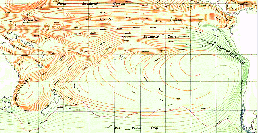
As can be seen in the graph above (click to enlarge), the Humboldt Current is one of the largest on the planet. It is infeasible that El Niño can arise from atmosphere and sun alone by warming this mass of water. Neither air temp or solar radiance change enough to cause this phenomena.
At this site you can watch animation of nearly 5 years of Argo data on the tropical region of the Pacific Ocean. It is fascinating and proves my earlier conclusion that the warm waters of El Niño arise from the eastern pacific and travel west – not the reverse as is the current (now defunct) theory. You need to set the start date on the left to the earliest date in 2007 and the end date to the latest in 2012.
I suggest you first watch the surface animation, then go the the 100m data. What you will see in the 100m is hot water upwelling off the coast of Costa Rica (which was not in the zone I originally predicted the upwelling would occur BTW). I have taken a few snaps of the data from Oct 2008 to Feb 2009 at 4 week interval to highlight what I discovered.
On this first image (click to enlarge) we see the very beginnings of the upwelling off the coast of Central America (area highlighted by red rectangle with a small blue dot). As time progresses the upwelling grows, moves west and another upwelling appears. The images are from 10_22_2008, 11_26_2008, 12_24_2008, 1_21_2009 and 2_25_2009.


Now some may ask why didn’t Argos detect the upwelling deeper (1000m)? The answer is in fluid dynamics. The hot spot is very narrow above whatever thermal vents are the source of this warming. The Argo floats are not very dense in this region. So the warm column of water upwelling has to spread out as it rises, making it more likely to be detected by the Argos floats. By the time it hits the surface the warm water really spreads out over top of the cooler layers below.
As this March 2009 surface image shows there are two upwellings in the area, but the one off Costa Rica is missed at the lower depths (again likely due to the density of sensors being so low in this area). And there appears to be a 3rd upwelling off the coast of Peru.

The activity of Nicaragua and Costa Rica is right along the Cocos Plate.

The Peruvian region I highlighted in the previous post and is linked to the Pacific Rise. Higher volcanic activity in these areas clearly cause more warm water to rise and heat the surface, creating the conditions for El Niño. Lower activity allows the cooler currents to dominate, bringing on El Niña.
fauxscienceslayer says
http://wattsupwiththat.com/2012/02/15/do-underwater-volcanoes-have-an-effect-on-enso/#comment-896973
Henry @ur momisugly fauxscienceslayer
The problem is that your theory and the one posted here does not fit in with the results that I am seeing from surface weather stations. Namely, similar to the theory of global warming being caused by increased GHG’s (CO2/CH4 etc), any theory that alleges that more heat than previously is caused by volcanic activity causing some extra warming of earth, presumes that more water vapor and CO2 is released into the atmosphere, forcing minimum temps. up, slowing down cooling, which in turn forces the average temps. up.
That is not happening. Global RH has been declining, not rising. Global warming by increased GHG’s is not happening. So, in the same way, global warming by more volcanic activity is not happening as evident from the results.
http://wattsupwiththat.com/2012/02/15/do-underwater-volcanoes-have-an-effect-on-enso/#comment-893299
It is not the minima rising, during the night, that is forcing up average temps.
It is the maxima increasing, during the day, that is forcing up the average temperature.
http://www.letterdash.com/HenryP/henrys-pool-table-on-global-warming
That clearly implies: the warming of earth must be due to: more (intense) sunshine and/or less clouds and/or less ozone
(there is someone who even thinks that more solar wind can force up maxima, but I have to get some more details on that theory)
Willis
The thermohaline current is driven by the wind.
The currents you depicted as a counter-example are driven by the wind.
Bill was correct. His post on the topic was very enlightening.
Henry P
I am more than happy to discuss science, but that requires you be informed of my Variable Fission Energy Theory, prior to dismissing same. Decay of higher order elements creates multiple ‘daughter atoms’ from the remnant neutrons, protrons and electrons as well as substantial heat. Svensmark made big news with his ‘cosmic rays cause clouds’ by nucleation of atmospheric SOx molecules from 3 nm to 50 nm needed for cloud formation. There is no mention of the continuous source, but supporting charts on the “Forbush Decrease” suggest that these “elemental SOx molecules” have a five day lag time between solar events and atmosphereic changes.
Cosmic and solar neutrinos do not leave known proxies, so variations over time are best shown by proven Sunspot corrolation. A drop of cosmic activity causes a drop in fission heat and fission produced SOx cloud seeding. If you lower the heat into the system, it follows that there would then be a drop in RH. I have been an Earth Science student for decades. There is no other possible explaination for the cyclic and well defined two base temperature states for the Glacial and Interglacial conditions. The Milankovitch Cycle is not set by CO2 changes, nor by “forcings or feedbacks”. It may well be that our Sun is a bit player. The Sun’s signal is strongest due to distance, but it is possible that all solar and Earth climate cycles are part of a Galactic or even Universal harmonics. Ignoring reality neither alters nor removes reality.
I think there is confusion about components and systems. The thermohaline current is not driven by the wind. It is merely the downward-flowing current in certain regions. Wind-driven surface currents happen to deliver water to the surface in those regions. Without the surface currents, different circulations would be created by the thermohaline forces. Without the thermohaline movement, the surface currents at those locations would flow someplace other than down. The existing thermohaline circulation is caused by the combination of its components (including the present continental boundaries).
Faux science player says
If you lower the heat into the system, it follows that there would then be a drop in RH
Ignoring reality neither alters nor removes reality.
HenryP says
Well, I would be interested in reading up on your theory if it conforms more or less to the mechanism of my observations, i.e.
more heat coming in, at a ratio of 7:3:1 maxima:means:minima , meaning it must be due to more to intense heat from the sun and/or less clouds and/or less ozone and / or whatever combination of processes you want to add,
like for example, consider some specific magnetic action or solar wind from the sun that pushes the clouds (that usually does contain small iron particles) more towards the poles instead of allowing it to linger longer at the tropics.
(W/m2 coming in at the equator is 684 whereas on average on earth it is 342 W/m2, going much lower towards the poles)
and,
AT THE SAME TIME
relative humidity dropping at (global) average rate of about -0.02% per annum since 1974.
http://www.letterdash.com/HenryP/henrys-pool-table-on-global-warming
From 2001 (probably already linked up-thread)
El Nino Tectonic Modulation in the Pacific Basin
Leabourne and Adams
http://www.geostreamconsulting.com/papers/Leybourne_Oceans_Fin.pdf
The “Radiative Balance” is a completely FALSE matrix. Massive amounts of Earth’s variable fission energy are hidden in the liquification of super heated, high pressure gases at the undersea vents AND in the endothermic reaction of elemental atoms forced into elemental molecules and elemental compounds. This is understandable if you read “Motive Force for All Clmate Change” and “Earth’s Missing Geothermal Flux” posted at the Faux Science Slayer website.
There is an ongoing private email exchange currently among the worlds top Earth scientists and
i will produce additional articles adding to this already well documented process in the near future. We will first Free Science from the Imperialist….we will then deliver Honest Science to the Empericalists.
FSS says
Massive amounts of Earth’s variable fission energy are hidden in the liquification of super heated, high pressure gases at the undersea vents AND in the endothermic reaction of elemental atoms forced into elemental molecules and elemental compounds
Henry says
It (your theory) does not fit in with (my) observations of surface temperature… If there were some unknown, unaccounted for, heat causing modern warming, or a part thereof, should it not be increasing minima driving up the average temps? That is not happening, if we look at the average global results. Similarly, that is how the carbon dioxide scam can be easily exposed.
http://www.letterdash.com/HenryP/more-carbon-dioxide-is-ok-ok
Thermohaline currents:
http://www.pik-potsdam.de/~stefan/thc_fact_sheet.html
“What is the thermohaline circulation (THC)?
As opposed to wind-driven currents and tides (which are due to the gravity of moon and sun), the thermohaline circulation (Fig. 1) is that part of the ocean circulation which is driven by density differences. Sea water density depends on temperature and salinity, hence the name thermo-haline. The salinity and temperature differences arise from heating/cooling at the sea surface and from the surface freshwater fluxes (evaporation and sea ice formation enhance salinity; precipitation, runoff and ice-melt decrease salinity). Heat sources at the ocean bottom play a minor role. ”
===========
Like the wiki page, this gives some real physics and blows it by fictional fisics memes.
These currents are not wind driven, true, they are driven by density differences, true. The ocean is a fluid liquid medium, these are convection currents arising out of the differences in density between hot water and colder water – this is a huge system. It is inconceivable that the massive amounts of heat being created at the ocean floor by volcanic and divergent ridges isn’t the major player here.
Not a minor role, but the main role in the “thermal” of thermohaline. The heat has to come from somewhere!
Just as in the atmosphere, which is also a heavy fluid medium, (gas is a fluid), heated fluid liquid water in one part of the ocean will rise as it becomes less dense and colder denser water will come in beneath it. This is how we get our winds in the atmosphere – the movement of parcels of air as one hot parcel rises and denser colder air comes in beneath it, volumes of air on the move, convection.
Including water vapour, the fluid gas water is anyway less dense than air, but becomes more so as it takes up heat from the Earth’s surface and rises to the colder heights where it releases it and condenses back into liquid water.
DENSITY differences in both systems. Convection currents in both systems. Both systems are fluid mediums.
One of the links I posted said that divergent ridges take millions of years to cool, the east pacific is a younger system, it is very active with high temperatures: http://eqseis.geosc.psu.edu/~cammon/HTML/Classes/IntroQuakes/Notes/plate_tect01.html
“The region where oceanic lithosphere is manufactured is topographically high because of the high temperatures associated with the thin lithosphere. The thermal expansion of the material beneath the ridge maintains the high elevation and produces a gravitational force that helps slide the two plates apart (this force is called ridge push).
The ridges are regions of earthquake activity. As you should expect, the pulling apart of the two plates is expressed by normal faulting events, which are usually very shall[ow], less than 15 kilometers deep because the high temperature beneath the ridge causes the rocks to deform more easily beneath that depth (and hence you can’t store the strain energy to produce an earthquake).”
High temperatures along all the ridge, “With a little study you can also deduce that the growth rates vary. For example, the east Pacific region is spreading faster than the central Atlantic.”
http://iceagenow.com/Three_Million_Underwater_Volcanoes.htm
http://iceagenow.info/category/volcanoes-leading-us-into-an-ice-age/submarine-volcanoes-more-important-than-we-realize/
AnonyMoose says:
February 19, 2012 at 6:15 pm
I think there is confusion about components and systems. The thermohaline current is not driven by the wind. It is merely the downward-flowing current in certain regions. Wind-driven surface currents happen to deliver water to the surface in those regions. Without the surface currents, different circulations would be created by the thermohaline forces. Without the thermohaline movement, the surface currents at those locations would flow someplace other than down. The existing thermohaline circulation is caused by the combination of its components (including the present continental boundaries).
The downward flowing current would be cold water. Heated water like heated air, will rise.
I’ve just posted this link elsewhere, it has a good description, with pictures, of how convection works in the ocean – the key to this in thermohaline heat is that convection begins by the fluid being heated at the bottom, because of the nature of gases and liquids, that’s how we get currents in air (wind) and ocean, they’re both fluids. Wind is volumes of air on the move and the thermohaline volumes of water on the move.
http://www.qrg.northwestern.edu/projects/vss/docs/thermal/1-how-does-heat-move.html
“When there is heat at the bottom of this air or water, the air or water molecules in contact with the heat start to move, and the molecules spread apart. The heated air or water becomes less dense. It rises up until it gets to air or water with the same density as it has, and when it gets there, it pushes the air or water that was there out of the way. At the same time, new air or water fills the space that was vacated when the heated molecules rose up. The air or water that gets pushed out of the way falls down. This sets up a circular motion. Air or water is heated at the bottom, travels to the top, cools, gets denser, falls, is heated again and the whole cycle starts again. Convection does not occur in space because there is no gravity. “
Myrrh says: “These currents are not wind driven, true, they are driven by density differences,”
No Myrrh. They ARE driven by wind. If density drove the current upon freezing, then the current would oscillate between the poles each year as ice froze and melted at the alternate poles. But it doesn’t oscillate annually, because it is driven by the wind.
The wikipedia page correctly identifies “thermohaline” as a poor and misleading term.
Willis was wrong, Bill was right.
Faux Science Slayer says:
“There is an ongoing private email exchange currently among the worlds top Earth scientists and
i will produce additional articles adding to this already well documented process in the near future. ”
Looking forward to reading the latest.
This has been around a while going by this paper that Google Scholar says is cited 29 times but AGU EOS says 0 times:-
‘More evidence indicates link between El Niños and seismicity’
Daniel A. Walker 1995
In 1988, evidence showed a correlation between the five extreme lows in the Southern Oscillation Index (SOI) from 1964 through 1987 and episodic seismic activity along the East Pacific Rise (EPR) from 20°S to 40°S. This area contains one of the Earth’s most rapidly spreading ridge systems (Figure 1), where large amounts of energy are released through submarine volcanism and hydrothermal activity. Now that another El Nin˜o/Southern Oscillation (ENSO) episode may have drawn to a close, it is time to examine additional seismicity and SOI values.
Observed coincidences are often the basis for discovery, and reviewing the available data led us to note several. Two distinct phenomena—El Niños and earthquake swarms—seem to occur almost simultaneously in spite of their irregular recurrence rates and durations. Also, we found that what may be the longest lasting of the past six Niños coincides with the longest lasting and most anomalous episode of seismic activity, which occurred from 1964 through 1992 along the EPR from 15°S to 40°S.
http://www.agu.org/pubs/crossref/1995/EO076i004p00033-01.shtml
Khwarizmi says:
February 20, 2012 at 2:52 pm
So your claim, Mr. Algorithm, is that it is the wind that causes the ocean water to sink around Antarctica?
I’ll wait here while you explain how that happens, how the wind drives the water from the surface right down to the bottom of the ocean at both poles …
w.
Tide Gauge Data – for a long list of stations – worldwide
http://www.psmsl.org/data/obtaining/
Khwarizmi says:
February 20, 2012 at 2:52 pm
Myrrh says: “These currents are not wind driven, true, they are driven by density differences,”
No Myrrh. They ARE driven by wind. If density drove the current upon freezing, then the current would oscillate between the poles each year as ice froze and melted at the alternate poles. But it doesn’t oscillate annually, because it is driven by the wind.
The wikipedia page correctly identifies “thermohaline” as a poor and misleading term.
Willis was wrong, Bill was right.
I don’t know why wiki is saying that – as I said earlier, I’m a newbie to all this and, I think, I am looking at it with my usual degree of bias, I don’t care who is right or wrong, I would like to know what the truth is because it has interested me. To that end, I have spent some considerable hours searching the internet for information on the subject and reading up on it – I’ve already posted some of that which I found particularly relevant – and overwhelmingly, except for wiki, it is described as not wind driven, but density driven. This makes sense to me, because I do know about density differences in liquids. I can only think that some here don’t understand what “density driven” means because they don’t understand density. To that end, I have given information to explain the very simple science of density in this. I’ll have another go.
Our weather system is density driven. The winds arise because of density differences in the gases which arise because of temperature differences. To begin to get the picture here you first have to have a picture of our atmosphere, it is a fluid ocean of gas with volume and weight. It is not empty space.. There is an immense fluid gas mass pressing down on us, you are walking around with a ton weight of this stuff pressing down on your shoulders. There are solids, liquids and gases, however, both liquids and gases are fluids, in other words, the ocean of gas above us is an entirely apt description of the mass of air which is our atmosphere; it moves as fluids do, things happen in it as they do in fluids, heat travels through it as it does through fluids..
Now, with this picture in mind, when there is part of this ocean of gas being heated the molecules of the gas expand and become less dense. This particular volume of heated gas rises because now less heavy than the gas in the ocean around it. The ocean of gas around it is colder relative to our heated volume’s now hotter state and, being colder means being heavier, more dense, and so the colder volume falls down coming beneath the volume of rising heated gas.
That is all wind is, volumes of gas moving from temperature differences because heat makes a volume less dense and therefore lighter and it rises, and the colder denser and heavier volume of gas moves in beneath to take its place.
Look up inshore and offshore winds, this is the process in a nutshell. The temperature differences arising because water and land have different heat capacities and so different speeds of heating up and cooling down, so the volumes of gas above them are heating up and cooling down at different speeds.
These volumes have different densities, and this means they are exerting different pressures, which is another way of describing this, that winds always flow from high pressure to low. High pressure means colder denser heavier gases and low pressure means warmer less dense lighter gases.
That’s the simple basic of our density driven wind system in our fluid gas atmosphere, Air. Winds are currents in the fluid ocean of gas above us, just as currents are currents in the fluid liquid water ocean, volumes of the medium on the move.
The ocean as a huge volume of fluid will be affected similarly when one volume of it is heated, colder volumes will flow beneath.
Having just had a brief exchange with Connolley, I would think the most likely reason wiki is saying something so strange is that he’s playing his usual mind games.. As Willis has just said, if you say the thermohaline system is wind driven, then produce the winds that do this driving of the current deep in the ocean.. That’s a lot of thousand of miles to account for.
The shape of the current as I see it, will be subject to the same sort of things as currents in the atmosphere; the heat sources, the patterns from a spinning Earth and local topography, can you call it topography beneath the surface? Anyway, if you want to understand what density driven means in the ocean, then study our wind systems in the atmosphere, because they are density driven.
As above, so below..
p.s. A couple of times in my last post I wanted to use the word “gravity” to further explain density, but didn’t because that would have made it much longer, but I’ve found someone who anyway explains it much better than I could. Density driven is also called gravity driven, because basically, this is a gravity driven system which has a greater pull on stuff which has more mass, this is what gives something “weight” relative to another.
What is a gravity current?
Answer: “A density current is any current set up in a fluid because some of the fluid is denser than some of the other fluid. The denser fluid will be acted on by gravity and be pulled to lower areas in the container holding the fluid. The less dense fluid will be displaced at the bottom or lower areas of the container and be forced up. The current, that density current that is created in a fluid, is driven by gravity, and a density current is also termed a gravity current.
Whew! That said, let’s look at some things. The “definition” supplied can be applied to broad areas, and rightly so. There are some advanced applications. But let’s look at one that is often analyzed and is fairly easy to grasp.
In oceanography, water of a different temperature or of a different salt content (salinity) has different densities, and you can probably see where this is going. The colder or saltier water will be more dense, and if a “quantity” of colder or saltier water is “pooled” somewhere adjacent to warmer or less salty water, the more dense water (owing to its temperature or salt content) will, by gravity, be pulled “in and underneath” the warmer or less salty water. This flow is called a density or gravity current.
It really is that simple, but the hydrodynamics involved in the movement of ocean currents is only partly understood. We still have a long way to go to get a handle on it.
In one more example, let’s look at something you’ve already seen. In a container on a table is a chunk of dry ice (solid carbon dioxide). It is submerged in water and is bubbling away. The air in our room is still, and we see the white carbon dioxide gas flowing over the side of the container, across the table and down to the floor. It will even flow across the floor if left undisturbed. There is a physical current of carbon dioxide flowing here. And it is acting the way it is because the CO2 is more dense than the air in our room. A density or gravity current has been set up. You’ve seen this many times in films or on TV. And now you can, if you choose, put a name to the phenomenon. You know why it is happening the way it is.
Note: We’re not really seeing the “white carbon dioxide gas” because CO2 is not visible. We’re seeing just a bit of water vapor in the air condensing in the presence of the cold CO2 gas, and that is what gives the “white” to the scene. Didn’t want you to be confused there.
If you’re investigating density or gravity currents, you’ve just cracked the door. Push it open and see what else there is to see. Start by using the links below for more information.”
From: http://wiki.answers.com/Q/What_is_a_gravity_current
Willis I’ll wait here while you explain how that happens, how the wind drives the water from the surface right down to the bottom of the ocean at both poles …
I am trying to find evidence that the cold “chimneys” actually sink to the bottom in the real world, and not just in words formulated to explain. I am trying to find some quantification of the volume of water displaced downward at the ice boundary each year, and what happens to the flow during the melting phase of the annual cycle. My hasty search parameters are not revealing much, and I have go do some work – so please allow me a day or two (max) to respond in better detail. Cheers.
Happy belated birthday, btw. Every day should be celebrated, so I don’t care if I’m late to the party!
Thanks, Khwarizmi, for the birthday wishes, and for reminding me that every day should be celebrated.
Regarding vertical currents at the poles, you could start with the observations of the noted explorer, Roald Amundsen.
w.
Willis,
The wikipedia page on thermohaline currents begins with wind as the primary factor driving not only water to the poles, but driving most of the density gradient, with evaporation of water causing both (i) cooling and (ii) increased salt concentration at the surface. Salinity increase at the ice growth boundary during winter is just a small seasonal contribution to this bigger thermo-haline picture, apparently, with wind doing most of the thermo-haline work by evaporative cooling. I guess that is why the thawing part of the annual sea-ice cycle doesn’t matter too much in the bigger picture.
At two regions in the North Atlantic to the west and south of Greenland, this cold dense water apparently plunges thousands of meters to the ocean floor without much mixing during transit, arriving at the bottom where it diverted southward in a current that flows morbidly over the wreck of the Titanic (an ideal place to measure the current, according to the maps). But at the next point in this story, where deep cold water is thrust or pulled upward into warmer surface regions, against the apparent gradient, I got lost in what seemed like haline-forced mumbo-jumbo, and returned instead to the pursuit of data supporting the theory.
Apparently there isn’t any.
There is evidence that a trickle of water flows downward from surface regions near the poles, e.g.:
==========
In May 2005, Peter Wadhams reported to The Times of London about the results of investigations in a submarine under the Arctic ice sheet measuring the giant chimneys of cold dense water, in which the cold dense water normally sinks down to the sea bed and is replaced by warm water, forming one of the engines of the North Atlantic Drift. He and his team found the chimneys to have virtually disappeared. Normally there are seven to twelve giant columns, but Wadhams found only two giant columns, both extremely weak.
http://en.wikipedia.org/wiki/Shutdown_of_thermohaline_circulation#Measurements_in_2004.2C_2005.2C_2008_and_2010
==========
But where is the evidence showing that these weak “chimneys” under the Arctic ice “normally sink to the ocean floor”? Again, there isn’t any:
==========
The actual flows in this model are based on current theories of the thermohaline circulation rather than actual data. The thermohaline circulation is a very slow moving current that can be difficult to distinguish from general ocean circulation. Therefore, it is difficult to measure or simulate.
Author: NASA/Goddard Space Flight Center, 14 November 2011
http://en.wikipedia.org/wiki/File:Thermohaline_Circulation_using_Improved_Flow_Field.ogv
==========
So all the currents that we know about are driven by the wind.
Bill didn’t say all currents are driven “exclusively” by the wind, incidentally. Bill was totally correct both semantically and technically, not totally false.
Even the so-called “thermohaline circulation”–if it actually exists as theorized—is driven by the wind, almost exclusively.
Algorithm, a simple thought experiment.
Take the atmosphere away from the earth, and leave everything else the same. Is it truly your contention that under those conditions there would be no currents at all, that the ocean would stop moving?
I say that as long as you heat the ocean at the equator and cool it at the poles, you will have currents with or without an atmosphere. If you want to believe it would all magically come to a halt, I fear I can neither stop you nor help you.
w.
Willis Eschenbach (February 22, 2012 at 10:13 pm) wrote: “[…] a simple thought experiment. Take the atmosphere away from the earth”
An open ocean not permitting evaporation? Fine example of abstract conception hopelessly divorced from thermodynamic reality. Apply for a teaching job at IPCC modeling school. You’ve proven yourself qualified.
Paul Vaughan says:
February 25, 2012 at 7:22 am
Paul, that’s why they call it a “thought experiment”. You could imagine a monomolecular layer of oil on the surface of the ocean if you wish. Or you could make the entire ocean out of oil if you wish.
The point, which you are flailing mightily trying to avoid, is this: thermal circulation is a reality and it doesn’t require wind. The ocean sinks at the poles, not because of the wind, but because it is cold.
As to your snide nastiness about applying for a teaching job, you can stuff that where the sun don’t shine. [trimmed, excessive. Robt]
w.
“We beckon so we can make amends,
and with the same flip of the hand we curse our friends.”
— Lights [ http://www.oilandgasinvestments.com/videos/video/GUXGAKg1o-4/Lights-Peace-sign-lyrics.html ]
Tip: Harald Yndestad, Norway (long record tide gauge data exploration…)
http://ansatte.hials.no/hy/bio/defaultEng.htm
cheers
Discussion raging in a similar vein at Hot Topic. My last comment in response to Mike Palin:-
—————————————————————————————————————————————————–
Richard C2 March 4, 2012 at 6:17 pm
Your comment is awaiting moderation.
“This is absolutely ridiculous. The vast majority of the energy supplied to the oceans comes from above. Period, end of report” –
No Mike, the earth’s heat flows are:-
84 TW solar (reduced by albedo)
44 TW geo (KamLAND)
See:-
http://hot-topic.co.nz/people-talking-6/#comment-30319
http://hot-topic.co.nz/people-talking-6/#comment-30307
http://hot-topic.co.nz/people-talking-6/#comment-30314
http://hot-topic.co.nz/people-talking-6/#comment-30317
http://hot-topic.co.nz/people-talking-6/#comment-30318
http://hot-topic.co.nz/people-talking-6/#comment-30320
From the last comment (30320):-
45.9 GW (climate science geo flux)
44.0 TW (geo-science geo flux)
Climate science is under-estimating geo heat by a factor of 958.6.
But feel free to check my calcs.
——————————————————————————————————————————————————
Willis, I’ve taken your critique of my hydrothermal estimate into account in comment 30317 – you may have further objections.
The thread sequence is broken in a few cases due to it being moved there from another post but we are making do. There is a lot going on up and down from the links above that might be of interest to anyone taking this feed.
The link to the quoted comment above is http://hot-topic.co.nz/people-talking-6/#comment-30322
Re my last comment.
I’m wondering if I’ve found Trenberth’s missing heat.
BTW Willis, I’ve made a comment subsequent to the links above making the correction that I’ve probably over-estimated hydrovent heating by a factor of 100 more or less (rather than 2).
I’m in ‘Permanent Moderation’ at Hot Topic so my comments get held up but others go straight through so give it time.