Last update: 4 February 2011
by Klaus Wolter
The views expressed are those of the author and do not necessarily represent those of NOAA.

El Niño/Southern Oscillation (ENSO) is the most important coupled ocean-atmosphere phenomenon to cause global climate variability on interannual time scales. Here we attempt to monitor ENSO by basing the Multivariate ENSO Index (MEI) on the six main observed variables over the tropical Pacific. These six variables are: sea-level pressure (P), zonal (U) and meridional (V) components of the surface wind, sea surface temperature (S), surface air temperature (A), and total cloudiness fraction of the sky (C). These observations have been collected and published in COADS for many years. The MEI is computed separately for each of twelve sliding bi-monthly seasons (Dec/Jan, Jan/Feb,…, Nov/Dec).
After spatially filtering the individual fields into clusters (Wolter, 1987), the MEI is calculated as the first unrotated Principal Component (PC) of all six observed fields combined. This is accomplished by normalizing the total variance of each field first, and then performing the extraction of the first PC on the co-variance matrix of the combined fields (Wolter and Timlin, 1993). In order to keep the MEI comparable, all seasonal values are standardized with respect to each season and to the 1950-93 reference period. The MEI is extended during the first week of the following month based on near-real time marine ship and buoy observations (courtesy of Diane Stokes at NCEP) summarized into COADS-compatible 2-degree monthly statistics at NOAA-ESRL PSD. Caution should be exercised when interpreting the MEI on a month-to-month basis, since the input data for updates are not as reliable as COADS, and the MEI has been developed mainly for research purposes. Negative values of the MEI represent the cold ENSO phase, a.k.a.La Niña, while positive MEI values represent the warm ENSO phase (El Niño).
You can find the numerical values of the MEI timeseries under this link, and historic ranks under this related link. You are welcome to use any of the figures or data from the MEI websites, but proper acknowledgment would be appreciated. Please refer to the (Wolter and Timlin, 1993, 1998) papers (NOW available online as pdf files!), and/or this webpage.
If you have trouble getting the data, please contact me under (Klaus.Wolter@noaa.gov)

How does the 1998-2000 La Niña event compare against the seven previous biggest La Niña events since 1949? Only strong events (with a peak value of at least -1.2 sigma) are included in this figure. Note that some events last through the full three years shown here (for instance, 54-56), while others revert to “normal” or El Niño conditions by the second or third year (especially in 64-66). The 1998-2000 La Niña does not resemble any previous event in this comparison figure. It started late (about three months later than the previous latest case), and it featured a superimposed annual cycle (peaking around May and troughing around November) that does not match the other events displayed in this figure. However, the weak La Niña period after the 1982-83 El Niño had similar characteristics. Click on the “Discussion” button below to find the comparison of 2010 MEI conditions against several strong La Niña events.
Discussion and comparison of recent conditions with historic El Niño events

How does the 2002-04 El Niño event compare against the seven previous biggest El Niño events since 1949? Aside from 2002-04, only strong events (with a peak value of at least +1.4 sigma) are included in this figure. The 2002-03 El Niño event peaked below that threshold, with just over +1.2 sigma in early 2003. Overall, I would rank it just barely in the top 10 El Niño events of the last half century. In its evolution, it bears some resemblance to the 1965-67 event (highest temporal correlation), but shared with 1991-93 its reluctance to drop below the zero line once it had run its course. The El Niño event of 2006-07 reached a similar peak as the 2002-03 event, but lacked ‘staying power’, and collapsed in early 2007. The most recent event (2009-10) will replace 2002-03 in this comparison figure by the middle of 2011. Click on the “Discussion” button below to find the comparison of 2010 MEI conditions against several strong La Niña events.

The six loading fields show the correlations between the local anomalies and the MEI time series. Land areas as well as the Atlantic are excluded and flagged in green, while typically noisy regions with no coherent structures and/or lack of data are shown in grey. Each field is denoted by a single capitalized letter and the explained variance for the same field in the Australian corner.
The sea level pressure (P) loadings show the familiar signature of the Southern Oscillation: low pressure anomalies in the west and high pressure anomalies in the east correspond to negative MEI values, or La Niña-like conditions. Consistent with P, U shows positive loadings along the Equator, corresponding to easterly anomalies near the dateline. Negative loadings in the far western and eastern Pacific, as well as to the south of the positive loading center, show that westerly anomalies are almost equally pervasive in these regions during La Niña. The meridional wind field (V) features high negative loadings north of the Equator, denoting the northward shift of the ITCZ so common during La Niña conditions, juxtaposed with even stronger positive loadings northeast of Australia.
Both sea (S) and air (A) surface temperature fields exhibit the typical ENSO signature of a wedge of positive loadings stretching from the Central and South American coast to the dateline, or cold anomalies during a La Niña event. They are flanked by negative loadings (warm anomalies during La Niña conditions) to its southwest and, to a lesser degree, to its northwest. At the same time, total cloudiness (C) tends to be decreased over the central equatorial Pacific and on the northeastern flank of the South Pacific Convergence Zone (SPCZ), sandwiched in between increased cloudiness north of Australia and the eastern-most equatorial Pacific.
Now just past its annual peak, the MEI explains 31.6% of the total variance of all six fields in the tropical Pacific from 30N to 30S. Although its temperature components dominate the MEI with over 40% of their possible variance, even P, V, and C join in with about a third, a quarter, and a fifth of their variance, respectively, at or close to their peak values during the year. Thirteen years ago, when the MEI was introduced to the Internet, the explained variance for Dec-Jan 1950/51-1997/98 peaked amounted to 32.7%. This slight drop-off reflects the diminished coherence and importance of ENSO events in the last 13 years, bottoming out just two years ago with 30.9%. The loading patterns shown here resemble the seasonal composite anomaly fields of Year 1 in Rasmusson and Carpenter (1982).

Consistent with full-blown strong La Niña conditions, all of the key anomalies in the MEI component fields that exceed or equal one standard deviation, or one sigma (compare to loadings figure), flag typical La Niña features, while no comparable El Niño-like features reach the opposite one sigma threshold. Significant negative anomalies (coinciding with high positive loadings) denote strong negative sea level pressure (P) anomalies over the Maritime Continent (down to -3.2 standard deviations west of Australia), significant easterly anomalies (U) along the Equator and centered on the dateline, significant northerly anomalies east of Fiji, while both sea surface (S) and air temperature (A) anomalies continue at or above -1 sigma in the central and eastern tropical Pacific basin. Significant positive anomalies (coinciding with high negative loadings) denote significant positive sea level pressure (P) anomalies over the eastern subtropical Pacific, significant westerly anomalies (U) along the Pacific coast of Mexico, as well as over western Indonesia where they reach +3.4 sigma, significant southerly anomalies (V) are found west of Hawaii, and northeast of New Guinea where they reach +2.1 sigma, warm sea surface (S) and air temperatures (S) reach almost two sigma east of Australia and west of Hawaii, and significantly increased cloudiness (C) covers the western Pacific and the eastern-most equatorial Pacific where it reaches +2.3 sigma.
Again, all of these cardinal anomalies flag La Niña conditions. The only missing key anomaly is cloudiness over the central equatorial Pacific (which should be suppressed, but is not).
Go to the discussion below for more information on the current situation.
If you prefer to look at anomaly maps without the clustering filter, check out the climate products map room.
Discussion and comparison of recent conditions with historic La Niña events

In the context of the rapid transition of the MEI into strong La Niña conditions, this section features a comparison figure with strong La Niña events that all reached at least minus one standard deviations by June-July, and a peak of at least -1.4 sigma over the course of an event. The most recent moderate La Niña events of 1998-2001 and 2007-09 did not qualify, since they either did not reach the required peak anomaly (the first one) or became strong too late in the calendar year (both).
The updated (December-January) MEI value has strengthened slightly to -1.62 standard deviations after almost dropping below -2 standard deviations in August-September. Nevertheless, the most recent value ranks 2nd for this time of year, clearly below the 10%-tile threshold for strong La Niña MEI rankings , but slightly weaker than the value recorded in 1974. If one were to take the average of all MEI rankings since July-August (a six-month period), the strongest La Niña half-year periods of mid-55, ’73-74, and late ’75 averaged slightly stronger than the current event, for now (this is means Rank 4 for the current event, up one from last month).
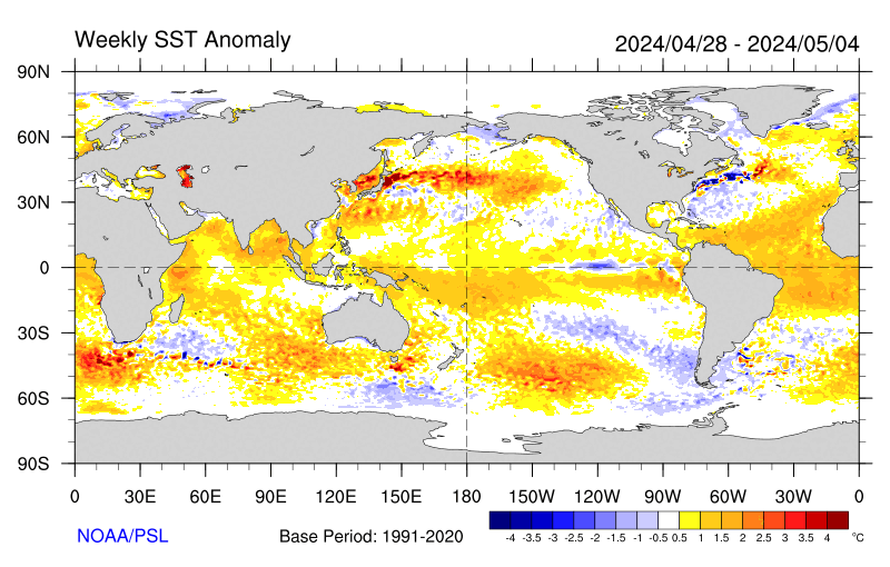
Negative SST anomalies are covering much of the eastern (sub-)tropical Pacific in the latest weekly SST map. Many of these anomalies are in excess of -1C.
For an alternate interpretation of the current situation, I highly recommend reading the latest NOAA ENSO Advisory which represents the official and most recent Climate Prediction Center opinion on this subject. In its latest update (6 January 2011), La Niña conditions are expected to last “well” into the Northern Hemisphere spring of 2011.
There are several other ENSO indices that are kept up-to-date on the web. Several of these are tracked at the NCEP website that is usually updated around the same time as the MEI, not in time for this go-around. Niño regions 3 and 3.4 showed persistent anomalies above +0.5C from June 2009 through April 2010, with a peak of +1.6C for Niño 3 and +1.8C for Niño 3.4 in December 2009, only to drop to about -0.5C or lower in both regions by early June 2010, reaching just shy of -1.0C for the month of July, and near -1.5C since October for both Niño 3 and 3.4 anomalies.
One only has to go back to the La Niña winter of 2007-08 to find seasonal Niño 3.4 anomalies that were lower than this year’s, hence the reluctance of Niño 3.4-based classifications to call this event a ‘strong’ event. Nevertheless, the weekly SST anomalies in January 2011 were consistently at or below -1.5C, so that the three-month average should ‘qualify’ for the strong category based on Niño 3.4 SST. For extended Tahiti-Darwin SOI data back to 1876, and timely monthly updates, check the Australian Bureau of Meteorology website. This index has often been out of sync with other ENSO indices in the last few years, including a jump to +10 (+1 sigma) in April 2010 that was ahead of any other ENSO index in announcing La Niña conditions. After a drop to +2 in June, July rebounded to +20.5, followed by values between +16 (November) and +27 (December), including +20 in January 2011. The last time that this index showed higher values for the average of any six months was during the same half-year in 1917(!), so any SOI-based classification would classify this event as one the second-strongest event of the last century. An even longer Tahiti-Darwin SOI (back to 1866) is maintained at the Climate Research Unit of the University of East Anglia website, however with less frequent updates (currently through March 2010). Extended SST-based ENSO data can be found at the University of Washington-JISAO website, currently updated through May 2010 (which ended up just slightly below the long-term mean value).
Stay tuned for the next update (by March 5th) to see where the MEI will be heading next. While La Niña conditions are guaranteed well into 2011, it remains to be seen whether it can rally once more to cross the -2 sigma barrier, and/or whether it will indeed last into 2012, as discussed six months ago on this page.
I believe the odds for a two-year event remain well above 50%, made even more likely by the continued unabated strength in various ENSO indices.
REFERENCES
- Rasmusson, E.G., and T.H. Carpenter, 1982: Variations in tropical sea surface temperature and surface wind fields associated with the Southern Oscillation/El Niño. Mon. Wea. Rev., 110, 354-384. Available from the AMS.
- Wolter, K., 1987: The Southern Oscillation in surface circulation and climate over the tropical Atlantic, Eastern Pacific, and Indian Oceans as captured by cluster analysis. J. Climate Appl. Meteor., 26, 540-558. Available from the AMS.
- Wolter, K., and M.S. Timlin, 1993: Monitoring ENSO in COADS with a seasonally adjusted principal component index. Proc. of the 17th Climate Diagnostics Workshop, Norman, OK, NOAA/NMC/CAC, NSSL, Oklahoma Clim. Survey, CIMMS and the School of Meteor., Univ. of Oklahoma, 52-57. Download PDF.
- Wolter, K., and M. S. Timlin, 1998: Measuring the strength of ENSO events – how does 1997/98 rank? Weather,53, 315-324. Download PDF.
h/t to WUWT reader FergalR
JP Miller says: “One of the weaknesses of skeptics’ argument — null hypothesis wrangling notwithstanding — is that there does not seem to be a coherent theory that explains the physics and climatology for how non-human factors could combine to explain changes in global temperatures. Sure, there are bits and pieces: the sun, ENSO, some combination.”
Apparently you have not read my posts about the multiyear aftereffects of ENSO. Those posts started with:
http://bobtisdale.blogspot.com/2009/01/can-el-nino-events-explain-all-of.html
http://bobtisdale.blogspot.com/2009/01/can-el-nino-events-explain-all-of_11.html
The most detailed explanation of why the East Indian-West Pacific SST anomalies can and do rise in response to El Nino AND La Nina events is provided in my series of posts:
http://bobtisdale.blogspot.com/2009/11/more-detail-on-multiyear-aftereffects.html
AND:
http://bobtisdale.blogspot.com/2009/11/more-detail-on-multiyear-aftereffects_26.html
AND:
http://bobtisdale.blogspot.com/2009/12/more-detail-on-multiyear-aftereffects.html
And for those who like visual aids, refer to the two videos included in La Niña Is Not The Opposite Of El Niño – The Videos.
Or if you like visual aids, this post includes two videos:
http://bobtisdale.blogspot.com/2010/06/la-nina-is-not-opposite-of-el-nino.html
Bob Tisdale suggests that the recharge process is failing.”
I did? Please quote me chapter and verse.
You said:
“so far the 2010/11 La Nina has not recharged it:
http://www.pmel.noaa.gov/tao/elnino/wwv/gif/wwva_std.gif”
So perhaps I misinterpreted that. If so please indicate whether it has recharged it as much as you would normally have expected by this stage of the La Nina.
Bob Tisdale said:
“It took a 3-year La Nina to recharge the tropical Pacific OHC after the 1997/98 EL Nino, Stephen, and the sun wasn’t “quiet” at that time. The 2010/11 La Nina is only halfway done. I don’t see any failure. So far the 2010/11 La Nina has not recharged fully, but it is being recharged:
http://www.pmel.noaa.gov/tao/elnino/wwv/gif/wwva_std.gif”
The sun not being ‘quiet’ at the time of the recharge process for the 1997/8 El Nino should have resulted in less cloudiness and a faster recharge than we are now seeing for the recharge of the 2009/10 El Nino. Do you see any evidence for that ?
From your data is cloudiness during this La Nina ‘normal’ or not ?
Note that since it is global cloudiness that I consider to be important and not regional cloudiness this specific point is not critical for me but if there is now more cloud than there ‘should’ be in the recharge zones then that would be helpful.
As regards global cloudiness being higher than it was I have the Earthshine project on side for that.
As regards the issue of poleward/equatorward jets I consider that increased meridionality always results in a net equatorward shift because the main power of the jets is clearly diverted around the equatorward side of the blocking highs simply due to their being more physical space on the equatorward side as a result of the geometry of a globe. Similarly ncreased zonality always results in a net poleward shift.
I think it is a given that the jets have become more meridional as the sun has become less active.
JP Miller says: “I said nothing to try to convince anyone of anything other than Stephen Wilde’s theories seem quite detailed and testable, leading me to ask if any scholars had taken it up and investigated it specifically.”
Stephen Wilde’s speculations are not based on data. He has not attempted to confirm his speculations with data, and he has been presented with data that contradicts his speculations on many occassions.
“Stephen Wilde’s speculations are not based on data. He has not attempted to confirm his speculations with data, and he has been presented with data that contradicts his speculations on many occassions.”
The contradictions are on short timescales whereas longer timescales do throw up correlations that are helpful. For example the air circulation changes between MWP, LIA and the present are consistent with my proposals.
Due to limited past data of a suitable nature the best means of verification or rebuttal is close observation of ongoing events.
So far, ongoing observations are fitting in well.
More meridional jets, increased cloudiness and albedo, a more negative AO, a cessation of stratospheric cooling, a cessation of tropospheric warming, a shift to negative PDO with dominant La Ninas, cessation of rising ocean heat content and a less active sun all starting from the late 90’s and all being a reversal of the earlier late 20th century trends and all being satisfactorily connected by my current climate description. No other current hypothesis links all those observed phenomena in a plausible narrative.
Furthermore the unexpected 2004 to 2007 observation that ozone increased above 45km was anticipated by my description which requires warming in the higher levels of the atmosphere when the sun is less active which is the opposite of established climatology.
Unfortunately Bob does not accept any of that as ‘data’.
Bob Tisdale said:
“There isn’t a reliable cloud amount/cloud cover dataset that’s updated monthly, so we have to rely on proxies. Based on tropical Pacific Precipitation Anomalies (24S-24N, 160E-90W) for the area east of the Pacific Warm Pool, it looks like cloud cover is where one would expect it for a La Nina:
http://oi53.tinypic.com/21dk1w7.jpg”
Well since it is low level cloud cover that we are concerned about I don’t think precipitation anomalies are a suitable proxy.
Thus Bob has no data either way and has not yet answered my questions as to whether the current recharge process is proceeding as quickly as did the recharge process after the 1997/8 El Nino.
That brings me back to Bill Illis’s post which contradicts this:
“The only missing key anomaly is cloudiness over the central equatorial Pacific (which should be suppressed, but is not).”
Although the central equatorial Pacific is not a critical area for my hypothesis it would be useful to know whether the more meridional jets are having any effect on cloudiness in the region.
So .. you guys mean to tell me that we have all this fancy satelite technology floating around up there …. We can measure surface temperature, long wave radiation exiting the atmosphere …. but we can’t measure the “cloudiness” of certain regions of the globe????
Heck .. I want my tax dollars back!!!
Stephen Wilde says: “Well since it is low level cloud cover that we are concerned about I don’t think precipitation anomalies are a suitable proxy.”
Speculation on your part, Stephen? Total Cloud Amount (anti)correlates best with DSR for the tropical Pacific. Refer to Pavlakis et al (2008). I linked it above, and here it is again:
http://www.atmos-chem-phys-discuss.net/8/6697/2008/acpd-8-6697-2008-print.pdf
There’s no reason for me to reply to the remainder of your comment due to the error in your opening sentence.
Deanster says: “…but we can’t measure the “cloudiness” of certain regions of the globe????”
The satellite-based cloud amount dataset, ISCCP…
http://isccp.giss.nasa.gov/
..is contraversial. There are volcanic ash biases in the appropriate years, and up until the late 1990s there was an area in Indian Ocean that wasn’t measured. It also is not maintained on a monthly basis.
Stephen Wilde: You have stated on an earlier thread here at WUWT that your “model” only works on multidecadal timespans. Why are you even discussing it on this thread?
Stephen Wilde says: “That brings me back to Bill Illis’s post which contradicts this…”
Did you read Bill Illis’s comments on this thread, Stephen? Or are you cherry-picking specific sentences?
He wrote in his February 6, 2011 at 4:28 am comment, “Then the precipitation anomalies, an even better measure of cloudiness.” And I presented the NOAA precipitation data, which you apparently looked at since you’ve linked it in a comment.
Ben G asked:
“Bob – do you think this could be down the cloudiness factor that Crosspatch mentions? If solar energy is not able to compensate for the oceanic release of heat, then it seems that a temperature stepdown of some kind might well be expected; that assumes the cloud cover situation continues.”
Bob Tisdale replied:
“Yup. According to Pavlakis et al (2008), downward shortwave radiation can rise as much as 40watts/sq meter during a La Nina. And if the cloud cover hasn’t reduced to allow this, then the La Nina won’t recharge as efficiently.”
So is it cloudier than expected or is it not ? Wolter says it is. Bill Illis says it isn’t.
Is the recharge happening as fast as it did after the 1997/8 El Nino or is it not ?
And how can precipitation be a good proxy for cloudiness when it is low non precipitating clouds that are the issue here ? Bill Illis seems to be relying on a proxy.
And I am discussing my model here because I would like to know whether the more meridional jets can alter recharge rates for the ENSO cycle. Meridionality/zonality seems to vary over multidecadal timescales so this is a relevant issue. It is not a critical issue however because I prefer to look at the global oceans as a whole rather than just the ENSO region but if the ENSO region is affected then that is useful to know.
Here is the Earthshine project data showing increasing cloudiness and albedo since around 2000 when I first noticed reducing jetstream zonality.
http://bbso.njit.edu/Research/EarthShine/literature/Palle_etal_2006_EOS.pdf
So clearly, increased zonality is failing to recharge the oceans as a whole because ocean heat content has been declining since 2003.
What I am seeking to ascertain here is whether the global trend is also reflected in a similar trend over the ENSO region. Wolter’s cloudiness observation suggests that it is.
Basically, the cloud datasets are contradictory and may not be reliable. The science community doesn’t officially accept the ISCCP or the Earthshine estimates for example.
One really big issue is the actual thickness/optical depth of the cloud. On average, the Earth is about 67% cloud covered, but 75% of the sunshine still gets through the 67% clouds anyway on average. The low level, moisture-laden, blue-underneath clouds will catch more of the sunshine that hits them but the higher stratus clouds don’t do much. Then there is the issue of how solar radiation reflected by the surface is just reflected back to the surface again by the clouds. Any cloud that looks white from the surface is, in fact, doing this. Then does anyone know how much IR a cloud will reflect/slow down. What frequencies are the most/least intercepted. And finally, how do we distiguish solar radiation reflected/intercepted by clouds versus solar radiation reflected from aerosols or dust or jet contrails or the invisibility cloaks of UFOs and the UN.
The OLR measurements from the satellites might be the most informative information available.
Stephen Wilde: If you were capable of entering data into a spreadsheet and plotting it, you wouldn’t have so many questions.
You asked, “So is it cloudier than expected or is it not ? Wolter says it is. Bill Illis says it isn’t.”
I’ve already answered this question and presented a graph of precipitation anomalies as a proxy for cloud cover.
You asked, “Is the recharge happening as fast as it did after the 1997/8 El Nino or is it not ?”
Based on the TAO project Warm Water Volume (above the 20 deg thermocline), the recharge has progressed more now on a percentage basis than during the initial phase of the 1998/99/00/01 La Nina, but there’s less recharging required:
http://i52.tinypic.com/2zycx8l.jpg
You asked, “And how can precipitation be a good proxy for cloudiness when it is low non precipitating clouds that are the issue here ?”
Did you read Pavlakis et al (2008) that I linked for you above? Tropical Pacific DSR is inversely proportional to Total Cloud Amount, not Low Level Cloud amount. In an earlier Pavlakis et al paper, low level cloud amount in the tropical Pacific was found not to be correlated with ENSO. Link to Pavlakis et al (2007):
http://www.atmos-chem-phys.org/7/2013/2007/acp-7-2013-2007.pdf
These are things you could confirm for yourself if you’d learn how to use a spreadsheet.
You asked, “And I am discussing my model here because I would like to know whether the more meridional jets can alter recharge rates for the ENSO cycle.”
Then, I will again suggest you learn how to use a spreadsheet, so that you can actually research what is being discussed.
You wrote, “Here is the Earthshine project data showing increasing cloudiness and albedo since around 2000 when I first noticed reducing jetstream zonality.”
Appearances are misleading. You might be fooling yourself and convincing yourself of a relationship when none exists. Have you plotted the earthshine data for the tropical Pacific, which is what is being discussed here? I already know the answer to that, and it’s no. So all you’re doing is speculating.
You wrote, “So clearly, increased zonality is failing to recharge the oceans as a whole because ocean heat content has been declining since 2003.”
You’ve provided nothing to document your claims. BTW, Global OHC has not declined since 2003. There is a positive trend. It’s significantly less than the trend from 1993 to 2003, but it is positive.
You wrote, “What I am seeking to ascertain here is whether the global trend is also reflected in a similar trend over the ENSO region.”
First, you need to establish the global trend, which you have not.
Bob,
I’m getting different information from different sources.
See here:
http://www.earthandocean.robertellison.com.au/
” A change to less cloud in the shift to a warm El Niño dominated Pacific decadal pattern in the late 1970’s and a change to more cloud following the shift to a La Niña dominated cool mode since 1998. Satellite data quantifies changes in outgoing shortwave and longwave radiative flux associated with cloud changes between 1984 and the late 1990’s. ”
So forgive me for not accepting you as the final arbiter.
I also think that one upmanship on the use and interpretaion of spreadsheets is inappropriate here. Everyone here knows that I am not a professional scientist.
Bob,
As regards ocean heat content the source of my impression was you:
http://wattsupwiththat.com/2010/01/31/nodc-revises-ocean-heat-content-data/
However I note subsequent further ‘revisions’.
Nonetheless it is quite enough for the validity of my hypothesis that the previous upward trend has become ” significantly less than the trend from 1993 to 2003″. The oceans don’t turn on a sixpence you know.
No doubt it will turn downward in due course provided the solar input is reduced by more cloudiness so as to offset more of the recharge process than was the case in the late 20th century when there were less clouds.
Bob,
That Pavlakis paper you kindly referred me to mentions DLR not DSR.
Furthermore it is contradictory:
They say this:
“We found no correlation between the
low-level cloud amount anomaly and the DLR-A[3.4] index
but this may be due to uncertainties in the ISCCP data.”
So the data source is not fit for purpose.
Previously they had said this:
“the most important role in determining the DLR reaching the
Earth’s surface, followed in order of significance by the cloud
amount of low, middle and high cloud, respectively.”
So the low cloud is more important but the data relating to it is inadequate.
Anyway we are going too far off course. The issue is Wolter’s assertion that:
“The only missing key anomaly is cloudiness over the central equatorial Pacific (which should be suppressed, but is not).”
I seem to have contrary assertions but no way of resolving them.
Bill Illis says:
February 7, 2011 at 2:12 pm
Thanks Bill. That is constructive even if it takes us no further.
For the moment I’ll stick with my proposition that more meridional jets with more looping about must increase the length of air mass interfaces to produce more clouds.
Whether that increased meridionality spills more clouds into the ENSO region is currently not certain. It would be an important point to resolve though.
However more cloudiness globally is enough to support my propositions since the ENSO region though important is only part of the larger global system.
Stephen Wilde says: “That Pavlakis paper you kindly referred me to mentions DLR not DSR.”
I linked two papers by Pavlakis et al on this thread, one on DSR in the tropical Pacific, one on DLR. I linked the one about DSR a second time on this thread personally for you. You even quoted my introduction to the the one about DSR, Pavlakis et al (2008), in one of your replies. I provided you a recent link to the DLR paper, Pavlakis et al (2007), because that’s the paper the discusses that low level cloud amount does not correlate with ENSO.
Stephen Wilde says: “Furthermore it is contradictory,” and after quoting from the paper about DLR, you wrote, “So the data source is not fit for purpose.”
Stephen, it’s not contradictory. They noted that low-level cloud amount does not correlate with ENSO and they noted that this may be due to the uncertainties in the data.
Again, I provided you with links to two Pavlakis papers on this thread, one about DLR in the tropical Pacific and one about DSR. Keep in mind that Pavlakis et al (2008) deals with DSR, and that DSR is capable of warming more than the top few millimeters of the ocean surface, and that we’re discussing how cloud amounts and DSR recharge the tropical Pacific during La Ninas.
Stephen Wilde says: “The issue is Wolter’s assertion…”
Have you checked which cloud cover dataset he uses for his MEI, and what the problems are with that dataset?
Ok, I’m back into the correct Pavlakis paper that deals with DSR and of course it must be the case that more cloud results in less DSR entering the ocean. We’ve all agreed that already.
The paper then says this:
“During the cold phases of ENSO in the central Pacific, values of DSR-ANE greater
than +30Wm−2 are observed west of the dateline.”
So the general rule is that in that specific area there is less cloud during a La Nina with increased DSR warming the oceans. The recharge process that we are all agreed on.
However Wolter says that currently the cloudiness is not being suppressed to the extent one would expect during La Nina.
That Pavlakis paper then relies on ISCCP cloudiness data but Bill Illis says this:
“Basically, the cloud datasets are contradictory and may not be reliable. The science community doesn’t officially accept the ISCCP or the Earthshine estimates for example”
So what are your grounds for contradicting what Wolter is saying ?
As regards global cloudiness I have pointed out two sources that show increased cloudiness globally since 1998 so I am reasonably secure on that issue.
I just want a bit more openness about the current state of cloudiness in the region where a La Nina would normally suppress cloudiness.
What do you have ?
And if low level cloud is not linked to ENSO as you say (despite the inadequacy of the data for establishing that fact) then we are back to the cloud amounts being affected by something else and here I suggest that the relevant ‘something else’ could well be the behaviour of the general air circulation system as it pushes cloud into (more meridionality or equatorward jets) or pulls cloud out of (more zonality or poleward jets) the ENSO regions.
Furthermore increased jetstream meridionality involving faster equator to pole heat cycling could well provoke intensification of the ITCZ too which would also have an effect on middle to high level cloudiness.
So here we have a critical diagnostic feature of the climate system but the cloud quantity data is inadequate, apparently.
There are four potential scenarios to consider
i) El Nino with increased cloudiness as compared to long term average.
ii) El Nino with decreased cloudiness as compared to long term average.
iii) La Nina with increased cloudiness as compared to long term average.
iv) La Nina with decreased cloudiness as compared to long term average.
And each of those scenarios will affect the recharge/discharge process differently and each of those scenarios will be controlled by factors external to the ENSO phenomenon.
Most likely by solar activity expanding or contracting the polar vortices and shifting all the air circulations so as to affect average cloudiness over ENSO regions regardless of the then current state of ENSO or PDO.
Well worth considering in my humble opinion.
Stephen Wilde: I assume your last two comments are directed at me.
I’m not the person who’s curious about Klaus Wolter’s cloud statement. You are. He’s apparently using a cloud dataset. Have you determined what it is and what its problems are? Apparently not.
You quoted Bill Illis, “Basically, the cloud datasets are contradictory and may not be reliable. The science community doesn’t officially accept the ISCCP or the Earthshine estimates for example”
I explained the problems with the ISCCP cloud amount data in an earlier comment. And if you were to “google scholar” ISCCP, you’ll find 8,000 plus returns, so the scientific community does accept the dataset.
You wrote, “Furthermore increased jetstream meridionality involving faster equator to pole heat cycling could well provoke intensification of the ITCZ too which would also have an effect on middle to high level cloudiness.”
Speculation on your part.
You wrote, “I just want a bit more openness about the current state of cloudiness in the region where a La Nina would normally suppress cloudiness.”
Then I suggest you ask someone who shares your concern. I do not. And I base that on the fact that your “current state of cloudiness” has not suppressed the recharge phase of ENSO.
You asked, “What do you have ?”
I have the ability to download data and plot it and interpret it. You do not. With that in mind, I’m not going to do your research for you.
You wrote, “And if low level cloud is not linked to ENSO as you say (despite the inadequacy of the data for establishing that fact) then we are back to the cloud amounts being affected by something else and here I suggest that the relevant ‘something else’ could well be the behaviour of the general air circulation system as it pushes cloud into (more meridionality or equatorward jets) or pulls cloud out of (more zonality or poleward jets) the ENSO regions.”
Your paraphrase does not represent what I presented on this thread, Stephen. I did not say, “low level cloud is not linked to ENSO.” I pointed you to a paper that noted that low level clouds were not correlated with ENSO. Tropical Pacific TOTAL cloud amount (including low level clouds) is (anti)correlated with ENSO, and is a function of coupled atmosphere-ocean responses to ENSO, primarily trade wind strength and the location of the warmer water.
You wrote, “Most likely by solar activity expanding or contracting the polar vortices and shifting all the air circulations so as to affect average cloudiness over ENSO regions regardless of the then current state of ENSO or PDO.”
Conjecture on your part. Please present the data that supports this.
You wrote, “Well worth considering in my humble opinion.”
Then I suggest you find a cloud cover dataset capable of confirming this. You could then download the data and present something other than speculation.
Stephen Wilde says: “As regards global cloudiness I have pointed out two sources that show increased cloudiness globally since 1998 so I am reasonably secure on that issue.”
And the dataset that Klaus Wolter uses for his MEI, COADS Cloudcover, shows a significant decrease in global ocean cloud cover from 1998 to 2007.