Last update: 4 February 2011
by Klaus Wolter
The views expressed are those of the author and do not necessarily represent those of NOAA.

El Niño/Southern Oscillation (ENSO) is the most important coupled ocean-atmosphere phenomenon to cause global climate variability on interannual time scales. Here we attempt to monitor ENSO by basing the Multivariate ENSO Index (MEI) on the six main observed variables over the tropical Pacific. These six variables are: sea-level pressure (P), zonal (U) and meridional (V) components of the surface wind, sea surface temperature (S), surface air temperature (A), and total cloudiness fraction of the sky (C). These observations have been collected and published in COADS for many years. The MEI is computed separately for each of twelve sliding bi-monthly seasons (Dec/Jan, Jan/Feb,…, Nov/Dec).
After spatially filtering the individual fields into clusters (Wolter, 1987), the MEI is calculated as the first unrotated Principal Component (PC) of all six observed fields combined. This is accomplished by normalizing the total variance of each field first, and then performing the extraction of the first PC on the co-variance matrix of the combined fields (Wolter and Timlin, 1993). In order to keep the MEI comparable, all seasonal values are standardized with respect to each season and to the 1950-93 reference period. The MEI is extended during the first week of the following month based on near-real time marine ship and buoy observations (courtesy of Diane Stokes at NCEP) summarized into COADS-compatible 2-degree monthly statistics at NOAA-ESRL PSD. Caution should be exercised when interpreting the MEI on a month-to-month basis, since the input data for updates are not as reliable as COADS, and the MEI has been developed mainly for research purposes. Negative values of the MEI represent the cold ENSO phase, a.k.a.La Niña, while positive MEI values represent the warm ENSO phase (El Niño).
You can find the numerical values of the MEI timeseries under this link, and historic ranks under this related link. You are welcome to use any of the figures or data from the MEI websites, but proper acknowledgment would be appreciated. Please refer to the (Wolter and Timlin, 1993, 1998) papers (NOW available online as pdf files!), and/or this webpage.
If you have trouble getting the data, please contact me under (Klaus.Wolter@noaa.gov)

How does the 1998-2000 La Niña event compare against the seven previous biggest La Niña events since 1949? Only strong events (with a peak value of at least -1.2 sigma) are included in this figure. Note that some events last through the full three years shown here (for instance, 54-56), while others revert to “normal” or El Niño conditions by the second or third year (especially in 64-66). The 1998-2000 La Niña does not resemble any previous event in this comparison figure. It started late (about three months later than the previous latest case), and it featured a superimposed annual cycle (peaking around May and troughing around November) that does not match the other events displayed in this figure. However, the weak La Niña period after the 1982-83 El Niño had similar characteristics. Click on the “Discussion” button below to find the comparison of 2010 MEI conditions against several strong La Niña events.
Discussion and comparison of recent conditions with historic El Niño events

How does the 2002-04 El Niño event compare against the seven previous biggest El Niño events since 1949? Aside from 2002-04, only strong events (with a peak value of at least +1.4 sigma) are included in this figure. The 2002-03 El Niño event peaked below that threshold, with just over +1.2 sigma in early 2003. Overall, I would rank it just barely in the top 10 El Niño events of the last half century. In its evolution, it bears some resemblance to the 1965-67 event (highest temporal correlation), but shared with 1991-93 its reluctance to drop below the zero line once it had run its course. The El Niño event of 2006-07 reached a similar peak as the 2002-03 event, but lacked ‘staying power’, and collapsed in early 2007. The most recent event (2009-10) will replace 2002-03 in this comparison figure by the middle of 2011. Click on the “Discussion” button below to find the comparison of 2010 MEI conditions against several strong La Niña events.

The six loading fields show the correlations between the local anomalies and the MEI time series. Land areas as well as the Atlantic are excluded and flagged in green, while typically noisy regions with no coherent structures and/or lack of data are shown in grey. Each field is denoted by a single capitalized letter and the explained variance for the same field in the Australian corner.
The sea level pressure (P) loadings show the familiar signature of the Southern Oscillation: low pressure anomalies in the west and high pressure anomalies in the east correspond to negative MEI values, or La Niña-like conditions. Consistent with P, U shows positive loadings along the Equator, corresponding to easterly anomalies near the dateline. Negative loadings in the far western and eastern Pacific, as well as to the south of the positive loading center, show that westerly anomalies are almost equally pervasive in these regions during La Niña. The meridional wind field (V) features high negative loadings north of the Equator, denoting the northward shift of the ITCZ so common during La Niña conditions, juxtaposed with even stronger positive loadings northeast of Australia.
Both sea (S) and air (A) surface temperature fields exhibit the typical ENSO signature of a wedge of positive loadings stretching from the Central and South American coast to the dateline, or cold anomalies during a La Niña event. They are flanked by negative loadings (warm anomalies during La Niña conditions) to its southwest and, to a lesser degree, to its northwest. At the same time, total cloudiness (C) tends to be decreased over the central equatorial Pacific and on the northeastern flank of the South Pacific Convergence Zone (SPCZ), sandwiched in between increased cloudiness north of Australia and the eastern-most equatorial Pacific.
Now just past its annual peak, the MEI explains 31.6% of the total variance of all six fields in the tropical Pacific from 30N to 30S. Although its temperature components dominate the MEI with over 40% of their possible variance, even P, V, and C join in with about a third, a quarter, and a fifth of their variance, respectively, at or close to their peak values during the year. Thirteen years ago, when the MEI was introduced to the Internet, the explained variance for Dec-Jan 1950/51-1997/98 peaked amounted to 32.7%. This slight drop-off reflects the diminished coherence and importance of ENSO events in the last 13 years, bottoming out just two years ago with 30.9%. The loading patterns shown here resemble the seasonal composite anomaly fields of Year 1 in Rasmusson and Carpenter (1982).

Consistent with full-blown strong La Niña conditions, all of the key anomalies in the MEI component fields that exceed or equal one standard deviation, or one sigma (compare to loadings figure), flag typical La Niña features, while no comparable El Niño-like features reach the opposite one sigma threshold. Significant negative anomalies (coinciding with high positive loadings) denote strong negative sea level pressure (P) anomalies over the Maritime Continent (down to -3.2 standard deviations west of Australia), significant easterly anomalies (U) along the Equator and centered on the dateline, significant northerly anomalies east of Fiji, while both sea surface (S) and air temperature (A) anomalies continue at or above -1 sigma in the central and eastern tropical Pacific basin. Significant positive anomalies (coinciding with high negative loadings) denote significant positive sea level pressure (P) anomalies over the eastern subtropical Pacific, significant westerly anomalies (U) along the Pacific coast of Mexico, as well as over western Indonesia where they reach +3.4 sigma, significant southerly anomalies (V) are found west of Hawaii, and northeast of New Guinea where they reach +2.1 sigma, warm sea surface (S) and air temperatures (S) reach almost two sigma east of Australia and west of Hawaii, and significantly increased cloudiness (C) covers the western Pacific and the eastern-most equatorial Pacific where it reaches +2.3 sigma.
Again, all of these cardinal anomalies flag La Niña conditions. The only missing key anomaly is cloudiness over the central equatorial Pacific (which should be suppressed, but is not).
Go to the discussion below for more information on the current situation.
If you prefer to look at anomaly maps without the clustering filter, check out the climate products map room.
Discussion and comparison of recent conditions with historic La Niña events

In the context of the rapid transition of the MEI into strong La Niña conditions, this section features a comparison figure with strong La Niña events that all reached at least minus one standard deviations by June-July, and a peak of at least -1.4 sigma over the course of an event. The most recent moderate La Niña events of 1998-2001 and 2007-09 did not qualify, since they either did not reach the required peak anomaly (the first one) or became strong too late in the calendar year (both).
The updated (December-January) MEI value has strengthened slightly to -1.62 standard deviations after almost dropping below -2 standard deviations in August-September. Nevertheless, the most recent value ranks 2nd for this time of year, clearly below the 10%-tile threshold for strong La Niña MEI rankings , but slightly weaker than the value recorded in 1974. If one were to take the average of all MEI rankings since July-August (a six-month period), the strongest La Niña half-year periods of mid-55, ’73-74, and late ’75 averaged slightly stronger than the current event, for now (this is means Rank 4 for the current event, up one from last month).
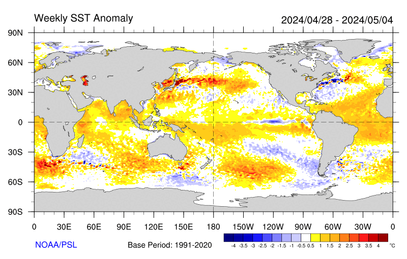
Negative SST anomalies are covering much of the eastern (sub-)tropical Pacific in the latest weekly SST map. Many of these anomalies are in excess of -1C.
For an alternate interpretation of the current situation, I highly recommend reading the latest NOAA ENSO Advisory which represents the official and most recent Climate Prediction Center opinion on this subject. In its latest update (6 January 2011), La Niña conditions are expected to last “well” into the Northern Hemisphere spring of 2011.
There are several other ENSO indices that are kept up-to-date on the web. Several of these are tracked at the NCEP website that is usually updated around the same time as the MEI, not in time for this go-around. Niño regions 3 and 3.4 showed persistent anomalies above +0.5C from June 2009 through April 2010, with a peak of +1.6C for Niño 3 and +1.8C for Niño 3.4 in December 2009, only to drop to about -0.5C or lower in both regions by early June 2010, reaching just shy of -1.0C for the month of July, and near -1.5C since October for both Niño 3 and 3.4 anomalies.
One only has to go back to the La Niña winter of 2007-08 to find seasonal Niño 3.4 anomalies that were lower than this year’s, hence the reluctance of Niño 3.4-based classifications to call this event a ‘strong’ event. Nevertheless, the weekly SST anomalies in January 2011 were consistently at or below -1.5C, so that the three-month average should ‘qualify’ for the strong category based on Niño 3.4 SST. For extended Tahiti-Darwin SOI data back to 1876, and timely monthly updates, check the Australian Bureau of Meteorology website. This index has often been out of sync with other ENSO indices in the last few years, including a jump to +10 (+1 sigma) in April 2010 that was ahead of any other ENSO index in announcing La Niña conditions. After a drop to +2 in June, July rebounded to +20.5, followed by values between +16 (November) and +27 (December), including +20 in January 2011. The last time that this index showed higher values for the average of any six months was during the same half-year in 1917(!), so any SOI-based classification would classify this event as one the second-strongest event of the last century. An even longer Tahiti-Darwin SOI (back to 1866) is maintained at the Climate Research Unit of the University of East Anglia website, however with less frequent updates (currently through March 2010). Extended SST-based ENSO data can be found at the University of Washington-JISAO website, currently updated through May 2010 (which ended up just slightly below the long-term mean value).
Stay tuned for the next update (by March 5th) to see where the MEI will be heading next. While La Niña conditions are guaranteed well into 2011, it remains to be seen whether it can rally once more to cross the -2 sigma barrier, and/or whether it will indeed last into 2012, as discussed six months ago on this page.
I believe the odds for a two-year event remain well above 50%, made even more likely by the continued unabated strength in various ENSO indices.
REFERENCES
- Rasmusson, E.G., and T.H. Carpenter, 1982: Variations in tropical sea surface temperature and surface wind fields associated with the Southern Oscillation/El Niño. Mon. Wea. Rev., 110, 354-384. Available from the AMS.
- Wolter, K., 1987: The Southern Oscillation in surface circulation and climate over the tropical Atlantic, Eastern Pacific, and Indian Oceans as captured by cluster analysis. J. Climate Appl. Meteor., 26, 540-558. Available from the AMS.
- Wolter, K., and M.S. Timlin, 1993: Monitoring ENSO in COADS with a seasonally adjusted principal component index. Proc. of the 17th Climate Diagnostics Workshop, Norman, OK, NOAA/NMC/CAC, NSSL, Oklahoma Clim. Survey, CIMMS and the School of Meteor., Univ. of Oklahoma, 52-57. Download PDF.
- Wolter, K., and M. S. Timlin, 1998: Measuring the strength of ENSO events – how does 1997/98 rank? Weather,53, 315-324. Download PDF.
h/t to WUWT reader FergalR
So there is cool La Nina and no heat recharge up to now due to increased cloudiness in vital area. Looks like the missing link in Bob T. ENSO theory – that Nino warms and Nina prepares for another Nino in never ending step rise.
JP Miller says:
February 5, 2011 at 7:35 am
One of the weaknesses of skeptics’ argument — null hypothesis wrangling notwithstanding — is that there does not seem to be a coherent theory that explains the physics and climatology for how non-human factors could combine to explain changes in global temperatures.
————————–
You seem to imply that your lot have a “coherent theory” that we deniers recognize and accept, but, because we are inveterate deniers, we just can’t help but make up incoherent alternate theories, out of sheer perversity.
Perhaps, all you meant was “I disagree”.
Caleb -February 5, 2011 at 8:00 am
phlogiston -February 5, 2011 at 8:54 am
Thanks for expressing some nagging thoughts, that are constantly swimming just below the surface of any climate discussions. Caleb, I always enjoy your honesty. GK
Since I can do this I have thrown together two other ways to visualise ENSO and perhaps other composites relating to the whole earth data. I hope this helps.
Links are at the end of this post.
An explanation of what I have done and what it is, otherwise is might take a moment to work it out.
Taken two dataset, HADSST2 and HADCRUT3 (which contains hadsst2 and crutem3) in gridded form and computed a Hovmoller diagram and the tropical weight mean temperature for a narrow latitude band. (which is a good metric for global, if rarely used, the poles just add noise)
An Hovmoller diagram is very simple. We are dealing here with a multiple dimension dataset where visualising on a sheet of paper is difficult.
Time
Temperature
Latitude
Longitude
Mapping four dimensions to three is done by calculating a vertical strip for each month, the north/south temperature profile, and lay them side by side. The result is a spatial temperature map.
The temperature data is double sine() weighted. Using a single sine() weighting is correct as part of a gridded to sphere mean calculation, but the earth has small temperature deviations at the equator and highest at the poles, it does not work very well, hence what I have done.
Could this be done for 1850 to date? Of course but the sparse data and overall temperature variation can this confused.
HADSST2 http://www.gpsl.net/climate/data/sst-hov1.png
HADCRUT3 http://www.gpsl.net/climate/data/had3-hov1.png
Here is an out of date 1850 to 2010 of the whole Hadcrut3
Warning: is a very wide image (8192 pixels) and might cause browser problems.
http://www.gpsl.net/climate/data/hadcrut3-1850-2010_holl.png (241k)
Oliver Ramsay,
JP Miller doesn’t get it. “It” being the scientific method, which utilizes the null hypothesis [which Miller also doesn’t understand].
Scientific skeptics have nothing to prove. We point out contradictions in the repeatedly falsified CAGW conjecture. That is the job of skeptics, and the only honest scientists are skepticals.
Miller swallows the cAGW story hook, line and sinker – and then demands a “coherent theory”. He doesn’t get the fact that skeptics have nothing other than the null hypothesis to support them.
In fact, such apparently simple conjectures as climate sensitivity are unknown. What is known is the fact that the catastrophic global warming due to CO2 conjecture has been repeatedly falsified.
Skeptics have done their job by debunking the “carbon” claim. It’s time for the alarmist crowd to man-up and admit that they cannot show any global harm due to CO2.
“One of the weaknesses of skeptics’ argument — null hypothesis wrangling notwithstanding — is that there does not seem to be a coherent theory that explains the physics and climatology for how non-human factors could combine to explain changes in global temperatures..”
JP Miller,
I think you have things backwards. Sceptics have been saying for a few decades that the “science isn’t settled”. But, all along it has been the Alarmists led by Gavin, Hansen, Trenbeth, ALGORE, et als that the science is settled, for they possess the Truth! Oh Happy Day! Your little strawman was clever, but I don’t anyone here is falling for it. Sceptics are actually doing real science and offer various theories and ideas. But no one has been able to come up with some comprehensive Unified Field Theorem for Climate (if one even exists).
BTW, there are several private meteorologists who with a very good deal of precision can forecast temperatur and precip anomalies for +12 months out. And none use the Greenhouse Gase Theories to support thier medium range climate projections. In any event, for quite a few years there have been private meterologists who in public argued that the Alarmists were wrong – they were cast out into the darkness. But, they were proven correct. Our atmosphere is a bit more complicated than the Team suggests.
I have commented to excess on the importance of lunar declinational tides in the atmosphere, in reference to the driving effects on the balance between zonal flows and meridional flow surges developed from different parts of the 18.6 North/South declinational patterns produced in the global circulation patterns.
Most of you no longer pay any attention to my posts.
As a result I have not posted as much nor as often lately.
I am shifting my focus from trying to be verbally articulate,
to beginning production of video animations of the visible effects,
that the average person can grasp in much more detail in much less time.
The differences in the repeating cycle forecast post to my web site from the current weather is IMHO due to the less active solar cycle now compared to the past three.
Revision from the beta passive forecast method I now use to an interactive interface process is in the works, now that I have time and some money to pay to get the developmental changes done.
I am trying to make a compilation of the many ideas of how the null hypothesis works as put forward by the posters on this site, and others and have been excising posted comment from threads to stitch together with segments of how I think it interconnects.
Edits are now being made, and results should be viewable in the coming months.
The forecast maps on my website have attracted the attention of Eric Floehr of “ForecastWatch” copies of the CSV files I used to generate maps from March of 2010 through January 9th of 2014, have been sent, for his use in evaluating the effective accuracy of the beta forecast process I currently use, and also to assist in development of revisions in the method used into an improved method.
I have already in the works several modifications to add to the process, along with projects to help others visualize the lunar tidal effects, I can see driving the cyclic oscillations in the global circulation. I am hoping that through “extended peer review” processes the regulars on this blog, and others will contribute to help form a more complete view of the Null Hypothesis, to the point that the application of the principles can generate a better long term daily weather forecast out to 15 years into the future.
PeterT,
At the link below (page 5 titled “Niño Region SST Departures (°C) Recent Evolution) you can find a small diagram in orange, blue, and black. The second one in the series is for region Niño 3.4. It shows a change in May of 2010 from orange (positive) to blue (negative). The blue reaches -1.5 in late August 2010. Actual numbers and 3-month running averages are shown near the end of the report. It is all well documented and clearly explained. Note that this takes you to the most recent weekly update as of 31 January 2011:
http://www.cpc.ncep.noaa.gov/products/analysis_monitoring/lanina/enso_evolution-status-fcsts-web.pdf
Espen at February 5, 2011 at 6:39 am says:
“….You’re right, but it still feels cynical to wish for a long cooler period (which, unlike warm periods, will be very deadly for maybe millions of people).”
////////////////////////////////////////////////////
I agree that the desire for a long cooler period will heap misery on millions of people. However, I see this as the lesser of two evils.
I do not consider that it is likely that within the next 10 years there will be a significant improvement in the understanding of the underlying science, unless the cloud experiments reveal something interesting. That being the case, the only way to defeat this madness is to see a substantial divergence between observed temperatures and model predictions. It may be that the ‘Team’ can massage the reported temperatures (although with satellite data and ARGO this will become more difficult), but that will not hoodwink the public when it is not possible for the ‘Team’ to hide the snow and increased heating costs due to the cold.
We need to slam the brakes on spending trillions of dollars on mitigation of a non problem not simply because of the financial hardship that this will bring to the developed nations, but also because without cheap energy there will be a drastic reduction in the standard of living in the developed countries AND it will curb developing countries from enjoying substantial increases in their standard of living. Why shouldn’t these countries have an opportunity to develop? It is wrong that so many people in developing countries (such as India and Africa etc) are without electricity in this day and age. It is wrong to force these people to endure such poverty and hardship which this Green agenda will certainly impose.
Whilst I accept that there can always be room for doubt and debate in the scientific aspects of AGW (albeit I consider the ‘theory’ does not even pass 1st base even at the most basic levels) what concerns me in particular is the prophesies of doom. There is no real evidence for such prophesies and they ‘exist’ solely in the ‘minds’ of computer models. If those promoting AGW would only do some research, they would readily appreciate that there is no historical evidence supporting such prophesies and in fact the historical evidence suggests the very opposite. Look at the development of civilisations. It is no coincidence that these really advanced in warmer climes (Minoan, Egyptian, Greek/Roman). In the past, there has never really been an advanced Northern clime civilisation save for perhaps the Vikings and not unsurprisingly they flourished in a time when there were warmer conditions and their impact waned as the Northern Hemisphere cooled. Look at the development out of the stone age from cooper, bronze, iron and you will note that generally there is a correlation in the time of these advances and the area where they occurred in relation to warm latitudes. There are other obvious benefits to having a warm climate (increased growing seasons) and one would expect more rainfall which would be beneficial but needs to be managed properly. I would also suggest that the mere fact that in most parts of the world we as a species wear clothes to keep us warm suggests that the planet is not at a temperature which is optomised for us and we as an animal would prefer warmer conditions. Leaving that last point aside, I guess those promoting AGW have never read a history book and God only knows why these guys never do any real world observational and/or field studies
In conclusion, I consider the best prospect of slamming the brakes on will be a lengthy and sustained cooler period. Regretfully, this will cause hardship for many but this will be the lesser of two evils. Since I do not like the cold, I shall probably emigrate to some warmer clime.
Juraj V. says: “Looks like the missing link in Bob T. ENSO theory – that Nino warms and Nina prepares for another Nino in never ending step rise.”
Apparently you’ve missed a few of my posts on La Nina, because I did not overlook the obvious link. Try this one:
http://bobtisdale.blogspot.com/2009/11/more-detail-on-multiyear-aftereffects_26.html
And this one:
http://bobtisdale.blogspot.com/2010/06/la-nina-is-not-opposite-of-el-nino.html
I have checked extended Tahiti-Darwin SOI data back to 1876 at the BOM site (standardised anomaly of the Mean Sea Level Pressure difference between Tahiti and Darwin).
No cycles are seen at all, it is plain random walk noise (a.k.a. red, 1/f^2 or Brownian noise). In this case expected departure from average is proportional to square root of time elapsed (that is, it can get arbitrarily large if we wait long enough). I guess this is what’s meant by unforced internal variability of the climate system.
For SOI a possible lower cutoff is also seen perhaps, possibly because air pressure differences can’t get arbitrarily large after all. However, the brief statistical analysis I’ve performed strongly suggests an underlying Wiener process with its scale invariant behavior and fake trends.
Bill Illis,
Thanks for your viewpoint. I was hoping you’d comment on this one. I always stop and read when I see your name as I am scrolling through a thread.
I don’t know, I think el nino by the fall is more likely than a double-dip la nina. Look at the recent CPC page heat content is already on the move eastward with positive subsurface temp anomalies already pushing toward the dateline.
All these multifarious correlations are a waste of time. Looking at the satellite temperature curve I could see that the current La Nina should bottom out approximately a year from now, which means during the next winter. If you thought this winter was cold wait till the next one gets here.
JP Miller says:
February 5, 2011 at 7:35 am
How is you using argumentum ad ignorantium a legitimate argument to outline a “weakness” in skeptic arguments? The hypothesis of AGW, whatever it actually is, does not need an alternative to be proven wrong. That’s actually the whole point…
Mark
I’d like to comment on the cloudiness point made throughout the thread.
There has actually been a massive reduction in the clouds over the Nino regions and especially over the International Dateline region which is where the biggest difference occurs between an El Nino and a La Nina.
The equatorial Pacific has been nearly cloud-free for 6 months. This is extremely unusual for an equatorial region.
There is some additional cloud over 8N where the equatorial counter-current is and over Indonesia and Australia and India which is a normal situation with a La Nina following an El Nino.
In fact, one of the reasons the surface is now warming in the east Pacific is because the lack of cloud means the Sun is beating down, day after day and warming the surface ocean. This is also one of the factors which eventually causes a La Nina or an El Nino to reach a peak and go the other way. This is also one of the factors which explains why a La Nina cause cooling – because the surface ocean is giving up its cooler-than-normal-but-still-warm-equatorial-heat more directly to space without clouds slowing the release.
So, the cloudiness comments above are way off base.
phlogiston says:
February 5, 2011 at 8:00 am
Bill Illis says:
February 5, 2011 at 4:11 am
There is either going to be a double-dip La Nina, an El Nino or neutral conditions.
Seems a safe prediction, keeping our options open!
Apart from those three, what else could happen?
—————————————
There is still a possibility the equatorial Pacific could get hit by a rogue stellar black hole in the next 6 months which will make the El Nino versus double-dip La Nina discussion mute.
Actually, I think the big red spot at 160E, 150 metres depth will win out and we will have a very strong El Nino later in 2011. I’m 3 for 4 at predictions at this time of the year based on this methodology.
http://www.cpc.ncep.noaa.gov/products/analysis_monitoring/ocean/weeklyenso/wkteq_xz.gif
Bill Illis says: “I’d like to comment on the cloudiness point made throughout the thread.”
Bill, what cloud cover/amount dataset are you referencing, and do you have a link?
Here’s the OLR up to 28th January:
http://www.cpc.ncep.noaa.gov/products/analysis_monitoring/enso_update/olra_c.gif
It dropped off in the last half of the month, but December was the highest in 20 years according to the monthly bulletin:
http://www.cpc.ncep.noaa.gov/products/analysis_monitoring/enso_advisory/index.shtml
I assume Dr. Klaus meant what he was saying, he didn’t mention cloudiness last month.
It would take me day to digest this.
The lesson though is just describing the evolution of weather is too much for the English language. All those guys with their “common sense” and their ” it’s snowing in my back yard, so that means the whole planet is heading for an ice age” don’t have what it takes.
Those of you talking about null hypotheses & randomness have to realize that statistical inference is MEANINGLESS prior to working out the nature of the complex conditioning (due to Simpson’s Paradox). [Nonlinearity does not necessarily mean chaos!]
–
Where many have gone wrong:
It’s the variance, not the mean, that moves with solar variation on decadal timescales, as I have shown here [ http://wattsupwiththat.com/2010/12/23/confirmation-of-solar-forcing-of-the-semi-annual-variation-of-length-of-day/ ].
In that article I focused on semi-annual variations, but it’s an easy step (for anyone with a handle on grain, extent, & integration across harmonics) to figure out that annual power varies inversely with semi-annual power.
It’s another small step to realize a consequence: Changes in solar cycle length drive multidecadal terrestrial oscillations (what some might call AMO, PDO, “60 year” cycles, or something else equally MISLEADING). [Keep in mind the following Earth features: (a) north-south asymmetry, (b) continental-maritime contrasts, (c) major discontinuity over Southern Ocean, & (d) QBO (quasi-biennial oscillation).]
Without getting hung up on the MISLEADING title, see figures 8-15 here to develop conceptual insight:
Leroux, Marcel (1993). The Mobile Polar High: a new concept explaining present mechanisms of meridional air-mass and energy exchanges and global propagation of palaeoclimatic changes. Global and Planetary Change 7, 69-93.
http://ddata.over-blog.com/xxxyyy/2/32/25/79/Leroux-Global-and-Planetary-Change-1993.pdf
(It takes a subtle eye to interpret the figures properly…)
–
Richard Holle, I suggest condensing your presentation to the following:
The 27 day lunar cycle is modulated by 3.6 & 18.6 year lunar cycles.
(It’s child’s play to verify this by looking at LOD’.)
Sometimes less is more…
Caleb says
——-
Personally I feel our climate has a huge inertia and is very hard to it throw out of whack, for it involves balances and counter-balances, with every reaction creating an equal and opposite reaction. Thus warming sets off cooling, and cooling sets off warming.
——–
It would be nice if this is true.
But the fact that climate varies a lot without human intervention tells me that it ain’t so. If subtle effects like orbital variations can cause ice ages then the human race ought to be very careful about adding it’s own subtle influences to the mix.
E.g. Pielke Snr is pushing both agricultural practices and aerosols as influencing climate. These are plausible influences. If you ever get to visit Asia look up at the sky; you can’t see it. It’s not much better in the USA or Europe.
So the hubris argument fails.
Richard Verney says
———-
We need to slam the brakes on spending trillions of dollars on mitigation of a non problem not simply because of the financial hardship that this will bring to the developed nations, but also because without cheap energy there will be a drastic reduction in the standard of living
———-
But what if you are wrong and that it is a problem. Remember we have not seen much warming yet. The temperature can go a lot higher. If this effects agriculture then your standard of living argument fails on the simple principle: you can’t eat a refrigerator.
LazyTeenager;
If Earth’s closest approach to the Sun suddenly started occurring in July instead of January (as it does now) then you’d soon be disabused of your notion that orbital variations are subtle effects.
Bill,
There may be some variation in the areas where cloudiness increases and where it decreases when levels of solar activity vary so as to shift the air circulation systems.
Currently global cloudiness and albedo is higher than it was during the late 20th century warming period.
Essentially you are suggesting that a recharge process is going on whereas Bob Tisdale suggests that the recharge process is failing.
I’d like to see that point resolved.