Sea Ice News #34

It has been awhile since I posted a  Sea Ice News. This one is a two parter. NSIDC’s Monthly Sea Ice News comes first, followed by some images and content I find interesting. Kudos to NSIDC for flagging the AO instead of “climate change” for the low January extent. – Anthony

From NSIDC:

Arctic Oscillation brings record low January extent, unusual mid-latitude weather

Arctic sea ice extent for January 2011 was the lowest in the satellite record for that month. The Arctic oscillation persisted in its strong negative phase for most of the month, keeping ice extent low.
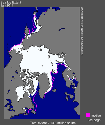
map from space showing sea ice extent, continents

Figure 1. Arctic sea ice extent for January 2011 was 13.55 million square kilometers (5.23 million square miles). The magenta line shows the 1979 to 2000 median extent for that month. The black cross indicates the geographic North Pole. Sea Ice Index data. About the data.

—Credit: National Snow and Ice Data CenterHigh-resolution image

Overview of conditions

Arctic sea ice extent averaged over January 2011 was 13.55 million square kilometers (5.23 million square miles). This was the lowest January ice extent recorded since satellite records began in 1979. It was 50,000 square kilometers (19,300 square miles) below the record low of 13.60 million square kilometers (5.25 million square miles), set in 2006, and 1.27 million square kilometers (490,000 square miles) below the 1979 to 2000 average.

Ice extent in January 2011 remained unusually low in Hudson Bay, Hudson Strait (between southern Baffin Island and Labrador), and Davis Strait (between Baffin Island and Greenland). Normally, these areas freeze over by late November, but this year Hudson Bay did not completely freeze over until mid-January. The Labrador Sea remains largely ice-free.
graph with months on x axis and extent on y axis

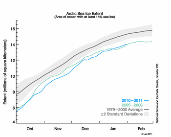
Figure 2. The graph above shows daily Arctic sea ice extent as of January 31, 2011, along with daily ice extents for previous low-ice-extent years in the month of January. Light blue indicates 2010-2011, green shows 2005-2006 (the record low for the month was in 2006), and dark gray shows the 1979 to 2000 average. The gray area around the average line shows the two standard deviation range of the data. Sea Ice Index data.

—Credit: National Snow and Ice Data CenterHigh-resolution image

Conditions in context

Air temperatures over much of the Arctic were 2 to 6 degrees Celsius (4 to 11 degrees Fahrenheit) above normal in January. Over the eastern Canadian Arctic Archipelago, Baffin Bay/Davis Strait and Labrador Sea, temperatures were at least 6 degrees Celsius (11 degrees Fahrenheit) higher than average. Temperatures were near average over the western Canadian Arctic Archipelago and Scandinavia.

As in December 2010, the warm temperatures in January came from two sources: unfrozen areas of the ocean continued to release heat to the atmosphere, and the wind patterns accompanying the negative phase of the Arctic oscillation brought warm air into the Arctic. Near the end of January the negative Arctic oscillation pattern broke down and turned positive, which usually favors ice growth. It is unclear how long it will remain in a positive mode.
monthly graph

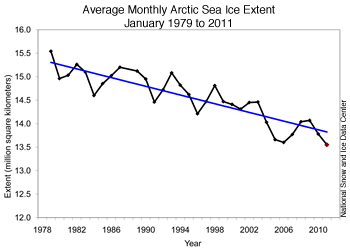
Figure 3. Monthly January ice extent for 1979 to 2011 shows a decline of 3.3% per decade.

—Credit: National Snow and Ice Data CenterHigh-resolution image

January 2011 compared to past yearsJanuary 2011 had the lowest ice extent for the month since the beginning of satellite records. The linear rate of decline for the month is –3.3% per decade.

Ice extent for the Arctic as a whole increased at an average of 42,800 square kilometers (16,500 square miles) per day through the month of January, which is about average.
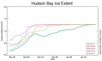
figure 4: masie grraph

Figure 4. This graph shows the ice extent in Hudson Bay from late November to the end of January, for the last five years. This year, Hudson Bay froze up substantially later than in previous years. MASIE data.

—Credit: NSIDC /NIC MASIE ProductHigh-resolution image

Slow regional ice growth

In contrast, regional ice growth has been particularly slow compared to past years. Hudson Bay did not completely freeze up until mid-January, about a month later than normal according to Canadian Ice Service analyses. The Labrador Sea region is still largely free of ice, except in protected bays along the coast. Normally at this time of year, ice extends several hundred kilometers from the coast all the way to northern Nova Scotia.
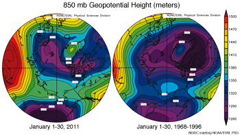
figure 5: pressure map

Figure 5. These images show high and low atmospheric pressure patterns for January 2011 (left) and the January 1968-1996 average (right). Yellows and reds show higher pressures; blues and purples indicate lower pressures, as indicated by the height of the 850 millibar pressure level above the surface, called the pressure surface. Normally, the pressure surface is nearer to the surface around the pole, winds follow the pressure contours around the pole (the polar vortex), and cold air is trapped in the Arctic. This year, the pressure pattern is allowing cold air to spill out of the Arctic into the mid-latitudes.

—Credit: NSIDC courtesy NOAA/ESRL PSDHigh-resolution image

Potential links with mid-latitude weather

While the Arctic has been warm, cold and stormy weather has affected much of the Northeast U.S. and Europe. Last winter also paired an anomalously warm Arctic with cold and snowy weather for the eastern U.S. and northern Europe. Is there a connection?

Warm conditions in the Arctic and cold conditions in northern Europe and the U.S. are linked to the strong negative mode of the Arctic oscillation. Cold air is denser than warmer air, so it sits closer to the surface. Around the North Pole, this dense cold air causes a circular wind pattern called the polar vortex , which helps keep cold air trapped near the poles. When sea ice has not formed during autumn and winter, heat from the ocean escapes and warms the atmosphere. This may weaken the polar vortex and allow air to spill out of the Arctic and into mid-latitude regions in some years, bringing potentially cold winter weather to lower latitudes.

Some scientists have speculated that more frequent episodes of a negative Arctic Oscillation, and the stormy winters that result, are linked to the loss of sea ice in the Arctic. Dr. James Overland of NOAA Pacific Marine Environmental Laboratory (PMEL) recently noted a link between low sea ice and a weak polar vortex in 2005, 2008, and the past two winters, all years with very low September sea ice extent. Earlier work by Jennifer Francis of Rutgers University and colleagues also suggested a relationship between autumn sea ice levels and mid-latitude winter conditions. Judah Cohen, at Atmospheric and Environmental Research, Inc., and his colleagues propose another idea—a potential relationship between early snowfall in northern Siberia, a negative phase of the Arctic Oscillation, and more extreme winters elsewhere in the Northern Hemisphere. More research on these ideas may shed light on the connections and have the potential to improve seasonal weather forecasting.

Further reading

Francis, J.A., Chan, W-H., Leathers, D.J., Miller, J.R., Veron, D.E., 2009. Winter Northern Hemisphere weather patterns remember summer. Geophys. Res. Lett. 36, L07503, doi:10.1029/2009GL037274.

Overland, J.E., Wang, M-Y., 2010. Large-scale atmospheric circulation changes are associated with the recent loss of Arctic sea ice. Tellus 62A, 1-9.

Cohen, J., J. Foster, M. Barlow, K. Saito, and J. Jones, 2010. Winter 2009-2010: A case study of an extreme Arctic Oscillation event. Geophys. Res. Lett., 37, L17707, doi:10.1029/2010GL044256.

====================================================================

NSIDC is correct about Hudson Bay. It took a longer time to freeze up this year.

JAXA extent shows 2011 about the same as 2010 right now – click for a large image

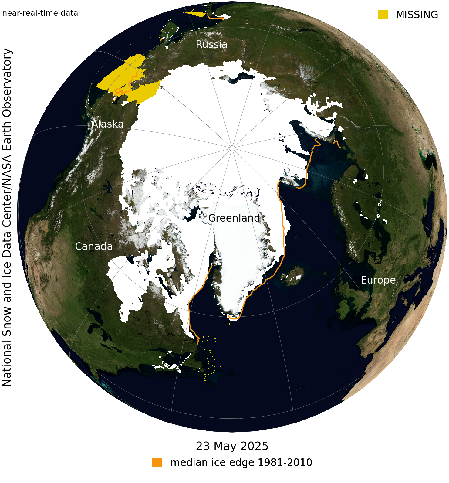
I would also add this NSIDC image, which shows that some of the areas missing ice extent are well outside of the Arctic circle, south of Greenland. This is consequence of the Arctic Oscillation and weather effects in the region.

I do find the NAVY PIPS ice thickness data interesting though. I’ve animated the Feb 1st plots from 2007 through 2011 together:

Values

The way I read it, above 80°N to the pole, we have an increase in thickness and an increase in expanse of thicker ice since 2009. The pressure ridges from wind driven ice pushed up against Greenland also seem to have minimized a bit on 2011. If this is the case, this may have some implications for the 2011 summer minimum.

You can plot individual dates here and do your own comparisons.

See more on the WUWT Sea Ice Reference Page here

0 0 votes
Article Rating
60 Comments
Oldest
Newest Most Voted
Inline Feedbacks
View all comments
John from CA
February 3, 2011 7:37 am

“I do find the NAVY PIPS ice thickness data interesting though.”
Great post and perspective on the “ice loss”.
What ice loss and how in the world can they refer to -10 to -30 F as warm? They are right about the Hudson Bay and Davis Strait but we’ve had a High positioned near the Davis Strait for most of the winter and SST slightly above freezing.
The stories about how open water in the Arctic are causing extreme winter weather is nonsense. What open water, the Arctic froze over very early this year and, as the Navy plots show (via your great animation), has increased in ice thickness over previous years.
The AO connection is interesting but they haven’t updated the AO anomaly chart on their site since November so its been difficult to follow. I guess its secret “stuff” ; )
AO:
http://ioc-goos-oopc.org/state_of_the_ocean/atm/ao.php

Bill
February 3, 2011 7:53 am

What do you think about the fact that the NSIDC, on its main image, has depicted the Sea of Bohai as ice-free the last two years even though Chinese media has reported it as half ice-covered?
I know the Sea of Bohai is not in the Arctic, but when the NSIDC portrays a section of the world’s northern oceans as blue, when in fact some 35,000 square kilometers are icebound, doesn’t that call in to question their data?

February 3, 2011 7:56 am

Arctic sea ice appears to be doing fine; increasing in thickness and spread in recent years. Sea ice loss has occurred almost entirely in the southerly regions, well beyond the Arctic Circle. When discussing this subject, would it not be more correct to refer to “Northern Hemisphere” rather than “Arctic” sea ice?

kwinterkorn
February 3, 2011 8:00 am

Another negative feedback system fighting GW: Less polar ice means more heat escapes the ocean, heats the air, then is radiated out to space. Warmer air temps for now, less heat in the system in the long run.
Also a negative feedback for GW: Lack of ice in the Arctic may raise albedo this winter, but so what?……There is no sunshine in the winter up there. Meanwhile, more cold and snow in the mid-latitudes, lowering the albedo where the sun still shines.
Along with increased tropical thunderstorms (if they are really occurring) and increased cloud cover as the warmer oceans transfer moisure to the air, many of the Earth’s climate subsystems seem to have negative feedbacks built in, as it were.
Makes sense, since the Earth’s climate has been quite stable for eons, hence must be dominated overall by negative feedback.

SteveE
February 3, 2011 8:00 am

It’ll be interesting to see where this puts the sea ice extent trend line over the next few years.
Could this data support the idea of global warming?

Jim Clarke
February 3, 2011 8:00 am

The fringes of the icecap are obviously more susceptible to weather patterns, like the AO, and are not very informative about climate. Even the core of the cap is susceptible to atmospheric and ocean oscillations, but perhaps not as much as the periphery. Since the core of the cap has been thickening for the last 4 years, I believe it is safe to say that the current trend is in opposition to the AGW theory.

FergalR
February 3, 2011 8:07 am

John from CA;
AO data is regularly updated here:
http://www.cpc.ncep.noaa.gov/products/precip/CWlink/daily_ao_index/ao.shtml
——————————————-
I’ve already posted this in tips and notes, but Cryosat-2’s data was released on the 1st:
http://earth.esa.int/object/index.cfm?fobjectid=6842
There’s a hell of a lot of it though, so I think there’ll be a long wait for reality to replace the models.

R. Gates
February 3, 2011 8:12 am

An excellent update…though I would still be suspect of putting too much stock in projecting anything based on the PIPS 2.0 model data. It is after all, just a model, but fortunately we’ll have real CryoSat 2 data in the near future and then can get some meaningful estimates on sea ice volume.
2011 will definitely be a very interesting year for Arctic Sea ice.

TomRude
February 3, 2011 8:24 am

As usual the cart before the horses: now the atmospheric circulation is caused by the change in ice coverage when in fact this is the reverse. Since it warming so much, perhaps they’ll explain the 1045hPa high pressure on the entire continental US…

Douglas DC
February 3, 2011 8:53 am

Looking at the “Sea Ice Page” here at WUWT, the ’07 comp to ’11, on the
“Chryosphere” today section, is it my lyin’ eyes or is there a thicker ice pack?

Stephen Wilde
February 3, 2011 8:55 am

Is the quiet sun causing the negative AO or
Is the negative AO a result of a ‘warmer’ Arctic or
Something else ?

richcar 1225
February 3, 2011 8:56 am

The Polar Ice Center has a new movie showing an arctic sea ice thickening model/movie from March to September 2010 based on the PIOMAS model.
http://psc.apl.washington.edu/zhang/IDAO/seasonal_outlook.html.
They say “The ensemble predictions are constructed by using the NCEP/NCAR atmospheric forcing from the previous 7 years (corresponding to 7 ensemble members) and the PIOMAS retrospectively estimated, with assimilation of satellite ice concentration data, ice and ocean conditions at a given date at which ensemble predictions start.”
It clearly disagrees with the PIPS2 model and sounds like they are using GCM’s. I have to believe that if researchers have already released ocean surface topographic maps of the Arctic Ocean from cryostat 2 data then sea ice volume maps have also likely beeen made but are for some suspicious reason have not been released.
On the polar ice site is an NAO vs sea ice volume hindcast model that appears to tell us from past history that the sea ice volume should build during NAO.
http://psc.apl.washington.edu/zhang/IDAO/retro.html#NAO
With the current NAO looking like it did in the 1960’s we should be building ice.
http://ioc3.unesco.org/oopc/state_of_the_ocean/atm/nao.php
I predict that the PIOMAS model will soon be headed for the same circular file that the CRU climate prediction model is now.

TomRude
February 3, 2011 9:05 am
Archonix
February 3, 2011 9:18 am

Based on reports here, the okhotsk sea has experienced unusually thick ice for the time of year. If the Russians, experts at navigating ice-bound seas, are getting their ice-breakers stuck then what does that tell us?

izen
February 3, 2011 9:23 am

kwinterkorn says:
February 3, 2011 at 8:00 am
“Another negative feedback system fighting GW: Less polar ice means more heat escapes the ocean, heats the air, then is radiated out to space. Warmer air temps for now, less heat in the system in the long run.”
The decrease in ice coverage in Winter is around 10% since 1980, thats 10% more sea surface to lose heat.
The decrease in ice coverage in Summer is around 30%, thats 30% more sea surface to GAIN heat from the Sun
The balance of which is greater will be down to the relative temperatures of the ice and open ocean in winter which will affect the amount of energy radiated proportional to T^4 (T in Kelvins).
And the relative albedo in the solar spectrum of ice/ocean when absorption of energy is happening in the summer.
Has anyone got figures or a link for these energy flows?

richcar 1225
February 3, 2011 9:36 am

Sea ice volume buildup is something the climate modelers desperately want to avoid because of its effect on their global heat budget. Hansen etal. used sea ice volume loss to explain some of the missing heat. In other words if the TOA imbalance is 1 watt/meter and the ocean can only account for .8 watts/meter then they want say that .2 went to melting the ice. If the sea ice volume builds rapidly then the ice is releasing heat and then needs to be subtracted from their estimate of heat accumulation in the ocean.
For instance if Argo demonstrates that there has been no accumulation of heat in the ocean for several years while the sea ice volume is rapidly building then then this heat released by the building ice must be subtracted from the Argo calculations to reveal cooling. Somebody recently estimated that up to one trillion cubic feet of ice may have been added over the last two years. Maybe somebody here can calculate how much heat was released in terms of watts/meter.
Rapid sea ice volume buildup will turn AGW on its head.

Myrrh
February 3, 2011 9:36 am

OK, I give up, not sure what I’m looking at. Where is the Sea of Okhotsk on the first sea ice extent map?

Peter Plail
February 3, 2011 9:57 am

Does the PIPS animation mean that multiyear ice is also increasing? There was a time when all we heard about was its decline.

Ian
February 3, 2011 10:05 am

YOU’RE ALL WRONG! I heard this on BBC Radio 4 today:
http://www.bbc.co.uk/podcasts/series/costearth
According to this programme, we’re well on the way to an ice-free Arctic with lots of mineral extraction opportunities arising.

hstad
February 3, 2011 10:09 am

That’s interesting! What about the Antartica Ice?
REPLY: Covered in our Sea Ice page 24/7/365, note the link at the end of the article – A

Peter Plail
February 3, 2011 10:19 am

R Gates
“It is after all, just a model, but fortunately we’ll have real ………. data in the near future and then can get some meaningful estimates….”
Just about sums up my scepticism about the whole global warming industry.

rAr
February 3, 2011 10:26 am

izen says:
February 3, 2011 at 9:23 am
“Has anyone got figures or a link for these energy flows?”
The linked paper discusses the energy flux in the arctic in detail.
http://nome.colorado.edu/HARC/Readings/Barry2.pdf
One thing that is missing in this discussion is the heat flow from the sea water to the sea ice during the melt season which would cool the sea water. The melt flux is considered to be part of the albedo!

Taphonomic
February 3, 2011 10:39 am

As an off topic side note, while Arctic sea ice is low, the Great Lakes are freezing to a degree greater than predicted.
The North American Ice Service has a report predicting the seasonal outlook for the Great Lakes for winter 2010-2011 at:
http://www.natice.noaa.gov/pub/special/great_lakes/2010/seasonal_outlook/text_with_graphics/great_lakes_seasonal_outlook_2010-2011.pdf
The report discusses the bases for the prediction and Page 8 shows the predicted ice cover for February 1 2011.
Actual ice cover for February 1 2011 can be observed online.
Eastern lakes:
http://www.natice.noaa.gov/pub/special/great_lakes/2011/charts/composite_east/el110201color.jpg
Western Lakes:
http://www.natice.noaa.gov/pub/special/great_lakes/2011/charts/composite_west/wl110201color.jpg
Erie has frozen solid already and the other lakes also exhibit greater freezing than predicted. It appears that this La Nina is bringing colder temperatures over the Great Lakes and more severe than normal ice conditions contrary to the predictions on page 4 of the report.
Future updates to actual ice cover can be tracked at:
http://www.natice.noaa.gov/products/great_lakes.html

rAr
February 3, 2011 10:43 am

richcar 1225 says:
February 3, 2011 at 9:36 am
“Somebody recently estimated that up to one trillion cubic feet of ice may have been added over the last two years. Maybe somebody here can calculate how much heat was released in terms of watts/meter.”
In 2008 GODAS added the OLR anomoly for the arctic into their monthly briefing.
For Nov. 2010 the anomoly was ~10 W/m^2 positive for OLR. [Page 21]
http://www.cpc.ncep.noaa.gov/products/GODAS/ocean_briefing_gif/global_ocean_monitoring_2010_12.pdf
For Dec. 2010 the anomoly was ~5 W/m^2 positive for OLR. [Page 20]
http://www.cpc.ncep.noaa.gov/products/GODAS/ocean_briefing_gif/global_ocean_monitoring_2011_01.pdf
The full archive is available at:
http://www.cpc.ncep.noaa.gov/products/GODAS/ocean_briefing_archive_pdf.shtml

John from CA
February 3, 2011 10:43 am

FergalR says:
February 3, 2011 at 8:07 am
John from CA;
AO data is regularly updated here:
http://www.cpc.ncep.noaa.gov/products/precip/CWlink/daily_ao_index/ao.shtml
=========
Thanks FergalR!
Myrrh says:
February 3, 2011 at 9:36 am
OK, I give up, not sure what I’m looking at. Where is the Sea of Okhotsk on the first sea ice extent map?
=========
Sea of Okhotsk is the top portion of figure 1 above the Bering Strait.
Key location for extreme up and down welling and proposed in one study I ran across as a key location for iron seeding the Pacific. Lack of seasonal ice in the Sea of Okhotsk was tied to decreased seasonal iron in the Pacific.

DaveS
February 3, 2011 11:00 am

If they have been adding a little bit each year to GISS and the world cools we may be able to see these manipulations. The difference between the satellite chart and GISS should be diverging for the last 25 years. The divergence should show a marked increase over the last 10 years. As the satellite has shown a slight warming and GISS is breaking records. This divergence should increase if the satellite shows cooling.

John from CA
February 3, 2011 11:15 am

Peter Plail says:
February 3, 2011 at 10:19 am
R Gates
“It is after all, just a model, but fortunately we’ll have real ………. data in the near future and then can get some meaningful estimates….”
Just about sums up my scepticism about the whole global warming industry.
========
PIPS 2.0 Concentration forecast side by side with Actual Microwave Imager plot.
http://www7320.nrlssc.navy.mil/pips2/archive/retrievepic.html?filetype=Concentration&year=2011&month=2&day=2
PIPS concentration forecasting appears to be cross-checked daily to actual conditions.

richcar 1225
February 3, 2011 11:37 am

Thanks for the data RaR.
I am not sure how to relate the OLR to the heat of fusion. What percentage of heat accumulates in the water under the ice and what percentage is released through OLR?
How do you separate the the OLR due to black body cooling from the latent heat released? Then we need to calculate the contribution to the entire global heat budget.

jason
February 3, 2011 12:11 pm

So does anyone know when and where we can start seeing cryosat data?

Myrrh
February 3, 2011 12:35 pm

Thanks John from CA. Maybe it’s the scale, or just unused to looking at this, but is the April 2010 showing more ice cover of the Sea of Okhotsk compared with Jan 2011?
http://nsidc.org/arcticseaicenews/2010/050410.html
The Russian sailors have only just been freed from being trapped in the ice. I can’t seem to get December 2010 picture at the time they got frozen in (*), the nearest I can find is http://nsidc.org/arcticseaicenews/2010/120610.html which is Nov 2010 and says that this November the second lowest ice-extent for that month. Is this how they got trapped? Thinking it was going to be this mild? I wonder how sudden the freeze and from what extent pre and post?
Prefer my maps with names … http://www.athropolis.com/map2.htm
(*) Can’t get the December map from the choices box, and I’ve tried typing in a few end December dates manually, but it comes up page not found.

rAr
February 3, 2011 12:50 pm

richcar 1225 says:
February 3, 2011 at 11:37 am
The latent heat of fusion is 335 kJ / kg of ice made. 10 W/m^2 of internal energy removed from water at 273K would make 1 kg of ice every 33,500 seconds.
Very little latent and sensable heat accumulates in the water.
See: http://nome.colorado.edu/HARC/Readings/Barry2.pdf
Calculating the contribution to the entire global energy budget is problematic because the amount of OLR radiated is a fuction of volume/mass of ice made and there are currently no historic data sets available, everything has been estimated.
FergalR says:
February 3, 2011 at 8:07 am
“I’ve already posted this in tips and notes, but Cryosat-2′s data was released on the 1st: http://earth.esa.int/object/index.cfm?fobjectid=6842
There’s a hell of a lot of it though, so I think there’ll be a long wait for reality to replace the models.”
Cryostat-2 will provide volume/mass data going forward but for now all that can be said is that for November 2010 ice was being made at the rate of approximately 1 kg per m^2 per 33,500 seconds faster that it had been in the past.

richcar 1225
February 3, 2011 1:19 pm

rAr,
Thanks for the info. I will study the pdf. We are all trying to learn on this site even if we are a little paranoid. I would be interested to hear your take on the pips2 vs Piomass controversy. Is Piomass being over influenced by by GCM modeling?

Editor
February 3, 2011 1:51 pm

In addition to the negative Arctic Oscillation noted in the NSIDC press release, the North Atlantic Oscillation (NAO) has been in an extended negative phase as is reflected in this NAO index chart;
http://www.cpc.ncep.noaa.gov/products/precip/CWlink/pna/month_nao_index.shtml
In fact the North Atlantic Oscillation (NAO) Index has been negative for last 16 months;
http://www.cpc.ncep.noaa.gov/products/precip/CWlink/pna/norm.nao.monthly.b5001.current.ascii.table
which is the longest stretch of negative monthly NAOs in the historical record.
If you look at the 60 year trend of the North Atlantic Oscillation (NAO) Index;
http://www.cpc.ncep.noaa.gov/products/precip/CWlink/pna/JFM_season_nao_index.shtml
it looks like the trend of more positive NAOs that began in the 70s has ceased, and the NAO may be trending towards more extended and strongly negative phases in the coming years.
Also, for those of you who would like to keep track Arctic Sea Ice by region, NSIDC’s monthly info is here;
ftp://sidads.colorado.edu/DATASETS/NOAA/G02186/
the plots are here;
ftp://sidads.colorado.edu/DATASETS/NOAA/G02186/plots/
data broken out by region for the last 30 days is here;
ftp://sidads.colorado.edu/DATASETS/NOAA/G02186/masie_extent_sqkm.csv
and Cryoshpere Today’s monthly plots can be found at the bottom of this page:
http://arctic.atmos.uiuc.edu/cryosphere/IMAGES/recent365.anom.region.4.html

John from CA
February 3, 2011 2:30 pm

Myrrh says:
February 3, 2011 at 12:35 pm
Thanks John from CA. Maybe it’s the scale, or just unused to looking at this, but is the April 2010 showing more ice cover of the Sea of Okhotsk compared with Jan 2011?
=======
Try The Cryosphere Today for comparisons but keep in mind they only show 30% and above for sea ice.
http://igloo.atmos.uiuc.edu/cgi-bin/test/print.sh?fm=01&fd=31&fy=2010&sm=01&sd=31&sy=2011

George E. Smith
February 3, 2011 2:31 pm

“”””” rAr says:
February 3, 2011 at 12:50 pm
richcar 1225 says:
February 3, 2011 at 11:37 am
The latent heat of fusion is 335 kJ / kg of ice made. 10 W/m^2 of internal energy removed from water at 273K would make 1 kg of ice every 33,500 seconds. “””””
Not necessarily; it might not make one single molecule of ice.
If the water is well mixed as you remove the 10W/m^2, the Temperature of the water will drop, and we presume that since it is water, that it is not at or below 273.15 K (for pure water)
But I agree; once you get ALL of the well mixed water down to 273.15 K, then you could make ice at about the rate you state.

Luther Wu
February 3, 2011 2:59 pm

That is such a misleading analysis by NSIDC, but I’m not surprised.
I’ve considered NSIDC ‘in the tank’ for the warmist taliban for quite some time, due to their propensity for taking a small data sample and trying to make a worst- case scenario with it. The Government just loves to tell scary stories, even if they have to make them up.
I view IJIS, et al, data daily. Only at the beginning of the month of January was arctic sea ice extent below it’s 10 yr. range and that was due to the blocking high sitting west of Greenland during December.
Anyone can see that the ice has recovered quite nicely.- regardless of what NSIDC says. The fact that the propagandists’ data and pronouncements can quickly be checked hasn’t seemed to affect their output, guess they still think they can fool all the people…

rAr
February 3, 2011 3:03 pm

richcar 1225
It looks like pips2 forecasts is for 120 hours and is reinitialized with the ice concentration data from SSM/I for each forcast. Piomass goes far into the future based on a NAO/AO forcing “locked” into a positive phase to simulate greenhouse gas-induced warming so it’s kind of an apples to oranges comparison.
Per Just The Facts post it looks like projections based on a “locked” positive phase for the NAO/AO isn’t going to produce results matching reality.

Louis
February 3, 2011 9:14 pm

“The black cross indicates the geographic North Pole.”
I bet the use of a “cross” was not a mere coincidence. It must have some hidden meaning for skeptics. Either you are putting the North Pole in your “cross-hairs” and targeting the ice for violence, or you plan to send Christian missionaries up there to reclaim those wayward elves. Which uncivil act are you planning? /Sarc

AndyW
February 3, 2011 9:56 pm

John From Ca said
“What open water, the Arctic froze over very early this year ”
For October
“Ice grew at an average daily rate for the month of October of 92,700 kilometers per day (35,800 square miles per day). This was similar to the growth rate in 2009, but slower than the growth rate following the 2007 and 2008 minimum ice extents. It was slightly faster than the 1979 to 2000 average rate of 82,200 square kilometers (31,700 square miles) per day.
At the end of October, ice growth slowed, and at the end of the month extensive open water areas remained in the Beaufort, Chukchi, Kara and Barents seas”
For November
“Arctic sea ice grew more slowly than average in November, leading to the second-lowest ice extent for the month. ”
So it started off fast and then petered out, the speed at the start is just because it was so low, not because it was colder.
Andy

AndyW
February 3, 2011 9:57 pm

Bob(Sceptical Redcoat) said
February 3, 2011 at 7:56 am
Arctic sea ice appears to be doing fine; increasing in thickness and spread in recent years. Sea ice loss has occurred almost entirely in the southerly regions, well beyond the Arctic Circle.
___________________________
In winter it cannot have increased spread except at lower lattitudes as it ia contrained by land mass. In summer it is not constrained and ice loss is increasing. So I don’t think your statement is correct.
Andy

John F. Hultquist
February 3, 2011 10:09 pm

Myrrh or anyone else wanting to learn more about the Sea of Okhotsk — the following link will be helpful. Then go to the home page and look for the update to the story. [Verity Jones, site owner, has been busy and not posting much the last few weeks.]
http://diggingintheclay.wordpress.com/2011/01/09/ice-build-up-in-sea-of-okhotsk/

Myrrh
February 4, 2011 1:28 am

John from CA & John F. Hultquist – thank you very much for the links, fascinating story.

Steve Keohane
February 4, 2011 7:39 am

kwinterkorn says: February 3, 2011 at 8:00 am
Another negative feedback system fighting GW: Less polar ice means more heat escapes the ocean, heats the air, then is radiated out to space. Warmer air temps for now, less heat in the system in the long run.

The more I look at things, this seems to be the way it is. Open water means dumping heat, and very little warming from the sun due to angle of incidence.
Just The Facts says: February 3, 2011 at 1:51 pm If you look at the 60 year trend of the North Atlantic Oscillation (NAO) Index;
http://www.cpc.ncep.noaa.gov/products/precip/CWlink/pna/JFM_season_nao_index.shtml
it looks like the trend of more positive NAOs that began in the 70s has ceased, and the NAO may be trending towards more extended and strongly negative phases in the coming years.

Very interesting link. The NOA appears to precedes global temperature trend by about a decade. The globe cooled from early 40s to early 70s, NOA had the same trend ten years earlier. Peak global temperature in 1998, NAO most positive in 1988. This would indicate that through 2020 we will see a continuing drop in global temperatures.

John from CA
February 4, 2011 8:00 am

AndyW says:
February 3, 2011 at 9:56 pm
John From Ca said
“What open water, the Arctic froze over very early this year ”
=======
AndyW,
The Arctic was iced with high concentration by November 1st. Open water hasn’t been on the scope all winter. Are you referring to sea ice below 80N like Hudson Bay?

John from CA
February 4, 2011 9:21 am

Myrrh says:
February 4, 2011 at 1:28 am
John from CA & John F. Hultquist – thank you very much for the links, fascinating story.
======
You’re welcome and interesting link.
The open water nonsense really throws me. If you look at the following, you’ll find a Volgoneft-131 (Russian tanker) in the Arctic at N 78°54′, E 176°48′.
Its been in that area all winter but I couldn’t dig up any reason why.
http://sailwx.info/shiptrack/shipposition.phtml?call=UFTA
Any ideas?

John from CA
February 4, 2011 9:51 am

footnote to my last comment: if you look at the Navy ice thickness figure, Volgoneft-131 (a Russian tanker) just “steamed” 20 nautical miles in 2.25 – 3+ meters of ice. That is a heck of a feat for a tanker?
Curious story in this, maybe its outfitted for Science or Oil exploration; pretty strange to float about all winter in -30° C conditions.

RACookPE1978
Editor
February 4, 2011 10:27 am

John from CA says:
February 4, 2011 at 9:51 am (Edit)
footnote to my last comment: if you look at the Navy ice thickness figure, Volgoneft-131 (a Russian tanker) just “steamed” 20 nautical miles in 2.25 – 3+ meters of ice. That is a heck of a feat for a tanker?
Now, compare that “feat” with the real-world, average-condition, happens-every-day-of-every-year-since-1914 of tankers steaming 20 nautical miles every 90 minutes for weeks at a time. But CAGW means the Arctic will be free of ice and sustaining ocean traffic?

geo
February 4, 2011 11:24 am

I’m not terribly pleased with what I’m seeing in the concentration patterns at Cryosphere, particularly on the Euro side. Looks worse now than it did in mid January. That says not good things to me about about ice thickness this late in the freeze season.

John from CA
February 4, 2011 11:44 am

racookpe1978 says:
February 4, 2011 at 10:27 am
John from CA says:
February 4, 2011 at 9:51 am (Edit)
But CAGW means the Arctic will be free of ice and sustaining ocean traffic?
========
The only soul on the face of the Earth that believes the Arctic will be ice free in the Summer is Al Gore. He’s probably dumb enough to believe it will be year round.
I really wish he’d “waltz” in and defend his statements but if “wishes were horses…”; probability is close to zero.
There is nothing worthy of note, I’ve seen over the years, in the Arctic. Ice melts and it freezes over again. Its a pretty boring story and the Polar Bears are doing just fine but would like the morons who stalk them from helicopters and tag their pups with stupid tags should lose their funding or “come on down” and DIE.

John from CA
February 4, 2011 11:54 am

geo says:
February 4, 2011 at 11:24 am
I’m not terribly pleased…
====
geo,
you failed to read the post? You missed the message that Navy ice depth is showing progressively improving conditions? You missed the comments about the nonsense related to “ice free”conditions this winter?
Ice on the side of the “Euro” is largely irrelevant if you understand the currents.

R. Gates
February 4, 2011 12:09 pm

I do remember last season when Steve Goddard went on endlessly about how the PIPS 2.0 data was showing the huge build up of thicker ice in the Arctic Basin and that led him to his 5.5 million sq. km. minimum prediction. What happened? Much of that “thick” ice cycled out into the warmer than normal waters of the Beaufort Sea and melted. Many skeptics it seems like to minimize the role of greater amounts of open water and warmer than normal water for both ice melt, as well as potential effects on atmospheric circulation. IMO, they ignore these dynamics at the peril of their own potential increase in the understanding of Arctic Sea ice dynamics.

eadler
February 4, 2011 12:20 pm

kwinterkorn says: February 3, 2011 at 8:00 am
Another negative feedback system fighting GW: Less polar ice means more heat escapes the ocean, heats the air, then is radiated out to space. Warmer air temps for now, less heat in the system in the long run.
This is true. Most of the heat arriving at the earth enters at low latitudes and much is transported to the Arctic by ocean and air currents. The Arctic region is a net emitter of heat.
Despite the negative feedback that you point out, the Arctic is getting warmer on average, over time. The Arctic glaciers are melting, and the area and volume of sea ice is decreasing, given the best measures we have. The Arctic is not losing heat fast enough to stop this trend, so far. Take a look.
http://svs.gsfc.nasa.gov/vis/a000000/a003800/a003817/

Myrrh
February 4, 2011 3:18 pm

John from CA
Is it moving or is the ice moving it?
Volgoneft-131 http://docs.google.com/viewer?a=v&q=cache:d5YiDmwIAysJ:ams.confex.com/amspdfpapers/46252.pdf+Volgoneft-131 aagh too long, I can’t copy and paste at the moment, the pdf file doesn’t come up, but is on the google quick view, page 9:
google Volgoneft-131 and go to the: 8B.6A HOMOGENIZING THE RUSSIAN FEDERATION CLIMATE RECORD BY …

John from CA
February 4, 2011 4:14 pm

Myrrh says:
February 4, 2011 at 3:18 pm
Is it moving or is the ice moving it?
==========
Hard to tell but I’m assuming its moving — 20 miles would be pretty extreme for ice movement in a day and it keeps going back to the same location.
So its a science vessel taking temperature measurements in the Arctic. Pretty amazing, they must have modified the hull.
“In general, radiosondes show less warming than expected in the lower troposphere and more cooling than expected in the stratosphere.”

John from CA
February 4, 2011 4:26 pm

R. Gates says:
February 4, 2011 at 12:09 pm
======
Hey R. Gates,
We’ll see what happens but we’ve got a way to go before the maximum which peaked late last year. We also have a lot more multi-year ice this year and La Nina isn’t due to ramp down until summer.
I doubt we’ll see a quick reverse to El Nino so ice 2011 minimum should be above average.

Patrick Davis
February 4, 2011 10:10 pm

Its a shame the Australian MSM won’t publish articles like this, we have to endure the same old story line. From the article..
“But sea ice has been melting dramatically in recent years, forcing polar bears during the open-water periods to either forage from shore or swim longer distances in search of sea ice.”
And…
“All the scientific studies show an incredibly high likelihood of extinction of two-thirds of the world’s polar bears in the next 40 years … and that includes all the bears in Alaska,” said Kassie Siegel, who is arguing the case for the Centre for Biological Diversity.”
http://www.smh.com.au/environment/climate-change/polar-bear-swam-nonstop-for-nine-days-20110204-1aguu.html

John from CA
February 5, 2011 12:00 pm

Patrick Davis says:
February 4, 2011 at 10:10 pm
Its a shame the Australian MSM won’t publish articles like this, we have to endure the same old story line.
=============
I agree — the stories are more fantasy than fact.
from the article:
“US Geological Survey in Alaska have tracked a female bear that swam nine days across the deep, frigid Beaufort Sea before reaching an ice floe 685 kilometres offshore.”
”All the scientific studies show an incredibly high likelihood of extinction of two-thirds of the world’s polar bears in the next 40 years … and that includes all the bears in Alaska,” said Kassie Siegel, who is arguing the case for the Centre for Biological Diversity.
Here’s the problem with articles like these. They fail to state the time frame, they are freak instances, and there isn’t much of any basis in fact that can support the “high likelihood of extinction of two-thirds of the world’s polar bears in the next 40 years”.
Also, the time frame in question would not have delivered “frigid” SST as there was sea ice in the Beaufort by November 15th so the episode likely occurred before the 15th.
Polar bears spend time on land during summer and have been observed hunting in coastal surf and along the coast line. Also, Bears in Alaska are eating machines — they’ll eat anything including grasses in the early spring. Warmer temperatures would increase not decrease the food supply. IMO, the article is complete rubbish.
November 1 and November 15 sea ice in the Beaufort Sea.
http://igloo.atmos.uiuc.edu/cgi-bin/test/print.sh?fm=11&fd=01&fy=2010&sm=11&sd=11&sy=2010

kadaka (KD Knoebel)
February 6, 2011 1:21 pm

From eadler on February 4, 2011 at 12:20 pm:

Despite the negative feedback that you point out, the Arctic is getting warmer on average, over time. The Arctic glaciers are melting, and the area and volume of sea ice is decreasing, given the best measures we have. The Arctic is not losing heat fast enough to stop this trend, so far. Take a look.
http://svs.gsfc.nasa.gov/vis/a000000/a003800/a003817/

Ah yes, the famous GISTEMP maps with the 1200km smoothing, allowing the esteemed Dr. Hansen to paint the Arctic red with just one or two actual temperature-reporting stations in or near the actual Arctic.

NASA’s announcement this year — that 2010 ties 2005 as the warmest year in the 131-year instrumental record — made headlines. But, how much does the ranking of a single year matter?
Not all that much, emphasizes James Hansen, the director of NASA’s Goddard Institute for Space Studies (GISS) in New York City. In the GISS analysis, for example, 2010 differed from 2005 by less than 0.01°C (0.018°F), a difference so small that the temperatures of these two years are indistinguishable, given the uncertainty of the calculation.
Meanwhile, the third warmest year — 2009 — is so close to 1998, 2002, 2003, 2006, and 2007, with the maximum difference between the years being a mere 0.03°C, that all six years are virtually tied.

Basically, not much is happening with the global temperature anomaly averages, which even Hansen has to admit. See the UAH January 2011 update:
http://www.drroyspencer.com/2011/02/uah-update-for-january-2011-global-temperatures-in-freefall/
Going by the satellite record of the lower tropospheric temperatures, after the 1998 Super El Nino things basically leveled out. See the second graph, global average sea surface temperatures are dropping, and have been for awhile now. “Global warming” is on hiatus.
Back to the NASA link:

Even for a near record-breaking year like 2010 the broader context is more important than a single year. “Certainly, it is interesting that 2010 was so warm despite the presence of a La Niña and a remarkably inactive sun, two factors that have a cooling influence on the planet, but far more important than any particular year’s ranking are the decadal trends,” Hansen said.

Of which one of the most important decadal trends [;-)] is the Pacific Decadal Oscillation (PDO):
http://www.appinsys.com/GlobalWarming/PDO.htm
A full oscillation lasts around 60 years, with cool and warm phases lasting about 30 years. Of the recent phases, a cool phase started around 1945, shifted to warm around 1977, with 2008 the apparent start of the next cool phase. Working backwards, a cool to warm shift happened around 1915.
Now we go to the maps at the NASA link, found below the animations, the five-year ones. “Global Temperature Anomalies averaged from…” xxx0 to xxx4, thus only the first half of the decades are available. Compare 1910-1914 to 1920-1924, covering the shift to warm around 1915. Note the dramatic color shift above Eurasia, what was cool became warm, while above Alaska the reverse happened. Next flip is 1940-1944 to 1950-1954, the 1945 shift to the cool PDO phase. Russia, China, Alaska and the western and central parts of Canada and the US, all cooled. A band of Pacific Ocean water stretching from China to the US went cool to warm. Etc, lots of changes.
For three decades, 1950-54, 1960-64, and 1970-74, we see the world in general cool off, with some increases in the Southern Ocean area. Then BANG, there’s the 1977 shift to a warm phase, as seen with 1980-84. The heat is on again. There’s an anonymously cold region formed near the Antarctic Peninsula, in the Pacific Ocean there are noticeable areas that do a temperature flip, as well as the Indian Ocean going from cool to warm. Straight through to 2000-04, we can see the heat spreading far and wide (aided by GISS’ gentle adjustments to the historical temperature record that made the past colder).
Now with a PDO cool phase apparently begun in 2008, with the global average sea surface temperatures dropping, knowing how important the decadal trends are, what do you think is going to happen for the next 25-30 years? More (C)AGW seems highly unlikely, even with the atmospheric CO2 concentrations steadily rising. However more Catastrophic Anthropogenic Climate Alarmism (CACA) is certainly likely, at least for another decade.

February 7, 2011 3:56 pm

Folks may find the following excerpt of interest.
The Washington Post

The Arctic ocean is warming up, icebergs are growing scarcer and in some places the seals are finding the water too hot, according to a report to the Commerce Department yesterday from Consulafft, at Bergen, Norway. Reports from fishermen, seal hunters and explorers all point to a radical change in climate conditions and hitherto unheard-of temperatures in the Arctic zone. Exploration expeditions report that scarcely any ice has been met as far north as 81 degrees 29 minutes. Soundings to a depth of 3,100 meters showed the gulf stream still very warm. Great masses of ice have been replaced by moraines of earth and stones, the report continued, while at many points well known glaciers have entirely disappeared.
Very few seals and no white fish are found in the eastern Arctic, while vast shoals of herring and smelts which have never before ventured so far north, are being encountered in the old seal fishing grounds. Within a few years it is predicted that due to the ice melt the sea will rise and make most coastal cities uninhabitable.

Oops. Never mind.
This report was from November 2, 1922, as reported by the AP and published in The Washington Post – 88 years ago

Wes M
February 7, 2011 10:06 pm

Dennis, I’ve shown a few people that WaPo article and not told them when the date was it was published, they went on about how it proves there is global warming going on, and then I show them the date and they can’t believe their eyes. I usually take 5-10 minutes with a believer in this nonsense and they become a skeptic fast.
SteveE:
No, the original article supports global warming but the science behind it shows there is little proof to believe the arctic is doomed. The ice that is there is getting thicker, and the ice loss from four years ago is coming back. In other words, its just another cyclical pattern that people are trying to claim is caused by human beings so they can get rich off it.
That WaPo article from 1922 is proof.