By Steve Goddard

Darkness is returning to the Arctic as the sun moves towards the horizon. In four weeks, the sun will disappear completely at the North Pole.

Solar Energy as a function of latitude and date
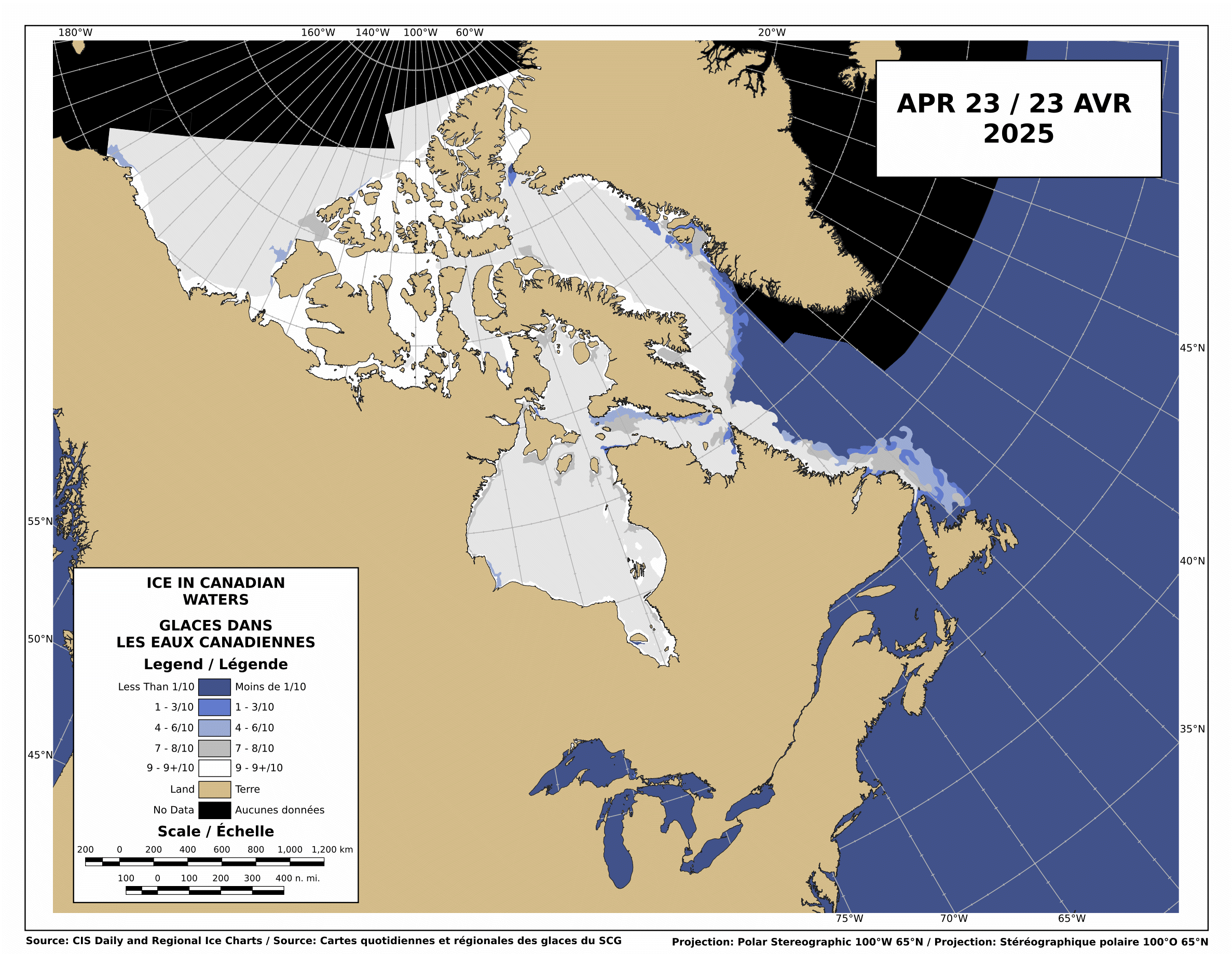
The Canadian Ice Service shows that there is still low-medium concentration ice blocking the Northwest Passage.

http://ice-glaces.ec.gc.ca/Ice_Can/CMMBCTCA.gif
If you owned a ship, would you send it through a route knowing it will face shifting pack ice, possible icebergs, fog, darkness, wind, storms and the possibility of an early freeze?
“The plans that you make can change completely,” he says. This uncertainty, delay, liability, increased insurance and other costs of using the Northwest Passage are likely to deter commercial shipping here. A ship with a reinforced hull could possibly make it intact through the passage. But if it got stuck, it would cost thousands of dollars for an icebreaker like the Amundsen to come to the rescue. So even if the Northwest Passage is less ice-choked than before, the route may not become a shipping short-cut in the near future, as some have predicted.
The Arctic Oscillation was negative for a few days, which allowed colder air to escape from the Arctic and warmer air to invade the Arctic. Note that the period of positive AO starting in early July corresponded to the Moscow heat wave. The cold air was trapped in the Arctic.

The negative dip this week allowed a blast of southerly air to melt and compact the ice during the past week, as we forecast in last week’s sea ice news.
")

http://ocean.dmi.dk/arctic/icecover.uk.php
Ice extent loss has dropped off dramatically in the last few days, as seen in the DMI graph above and the JAXA graph below.

Note that there was little loss in ice extent during 2006, after August 22.

What does the remainder of 2010 hold? Difficult to say. NCEP forecasts freezing temperatures over the broken ice in the Beaufort Sea during the next two weeks.

http://wxmaps.org/pix/temp2.html
If the remainder of the summer follows a path like 2006, 5.5 million is the right number. Another blast of southerly wind during the next few weeks. and it goes below 5.5. All of the ice indexes currently show 2010 ahead of 2008. DMI and NORSEX show it ahead of 2009 as well. JAXA also shows that the ice area curve has flattened. Ice area is always less than extent, and area trends tend to lead extent by a week or two.

There are large areas of low concentration ice which are vulnerable to compaction, spreading or melt.

My forecast remains unchanged. 5.5 million, finishing above 2009 and below 2006. Same as it has been since May.
The video below shows ice movement in the Beaufort Sea this week. Earlier in the week, it was compacting rapidly, now it is slightly expanding.
It all comes down to the temperature and wind over the next few weeks.
PIOMASS forecasts continue to stray further from the mark. Areas in red are places where PIOMASS incorrectly forecast melt. Solid green is the opposite misprediction.

Lindsay and Zhang forecast a minimum of 3.96 million in July.
The modified NSIDC image below shows ice loss during the last week. Mainly in the Beaufort Sea.

The modified NSIDC image below shows ice gain since 2007 in green, loss in red.

I’m not going to make a forecast for the next week, because there aren’t any dominant indicators either way.

Updated 7-day chart. Looking as sweet as a nut, hugging the line nicely.
http://img828.imageshack.us/img828/2764/7day20100823.png
Not much danger of a latent dip now, the equinox whip-lash has nearly taken over. From the 28th the outcome will be locked and loaded. If melt slows slightly at the end and the 7-day average crosses stasis early on the 7th, we’re on target for 5.39 x 10^6 +/- 0.10. The optimum for max winter freeze is the 11th, which would give us 5.19 x 10^6 +/- 0.10 as this year’s minimum. The variance is low (though it has picked up a bit in the past week). It therefore now looks more likely we’re headed for the 11th if conditions remain fairly stable.
I am becoming convinced the last minute dips in 2005/2006 are indeed a function of ice melt hysteresis and would appreciate input from ice experts. In order to change fully from melt to freeze it seems the influx of energy needed to satisfy the latent heat of state change has a time lag. If the deceleration of melt is not synchronized with the decline in energy coming from the sun as we head for equinox, a ‘correction’ takes place. That flux in effect reverses and causes an increase in melt at the surface, producing the characteristic last minute dip. I imagine there must be an energy gradient within the ice which penetrates deeper (and therefore stores more energy) depending on the internal/external temperature differential.
The same thing appears to be true the other way around. Melt is slowed at the March equinox if it commences too early. There is also a less defined effect, dependent on the freeze performance beforehand, in late May. While looking for evidence of these effects, it also became apparent (to me anyway) that the entire ice sheet and cycle exhibits pronounced hysteresis (i.e. the outcome of one year depends to a large degree on the behaviour of the previous one and possibly more). I regard the implications of that as immense.
http://img291.imageshack.us/img291/7015/pinballmachine.png
Günther Kirschbaum says:
August 23, 2010 at 11:45 pm
To be fair, I see some areas now with 90-100% sea ice concentration in the latest webcam images.
I’m struck by how thin the ice is. Living at the Baltic Sea, I’ve of course looked at the ice from a ship very often. This ice may well be less than a meter thick practically all over. There is no sign of significantly thicker ice of considerable extent anywhere in the images. And you can also see that the dark surface in some images isn’t really open water but thin overnight type of ice, like 5cm or so. Refreezing is taking place and that is the reason why all the area looks like high concentration ice in the satellite images.
Günther Kirschbaum,
The web cam location is north and west of the the Northwest Passage.
http://mgds.ldeo.columbia.edu/healy/reports/aloftcon/2010/20100824-1401.jpeg
This is the closest Google Map would allow. It wouldn’t give exact, but it’s near, less then 1 degree both ways.
http://www.findlatitudeandlongitude.com/
David W,
You wrote “Interesting, Cryosphere Today shows an increase in area for what I think is the first time this melt season. ”
Actually, CT data showed an increase in ice area over the previous day on July 2, 12, and 20 and on August 1, 5, 12, 14 and 15 before the most recent two days of increasing area on August 21 and 22 (see data posted at http://arctic.atmos.uiuc.edu/cryosphere/timeseries.anom.1979-2008). Obviously, it will at some point increase and continue to do so for more than two days but it’s hard to say when.
I don’t know how to embed Youtube movies, but here’s one that shows the melting season so far:
>Amino Acids in Meteorites says:
>August 22, 2010 at 6:10 pm
>I don’t get the obsession with hanging on to global warming. It’s not happening. Try >to come to terms with that.
It depends on what your definition of the word “is” is…
I don’t know if anybody will read this, but it seems the best place to post this now that the mid-week update is closed to comments.
Preliminary JAXA numbers for 08/25 are up today. Both today and yesterday lost above average ice extent. The only good news to get from the numbers is that we caught up with 2009 a bit for both days and left 2008 decently on both days. At ~206000 km^2 ahead of 2008 now with 2008 still losing the most between now and the minimum, I hope all the claims of 2010 being in a race with 2008 (relative to races with other years) have come to an end now. There is still a slight chance of reaching that level, but it’s lower than finishing above 2009.
It really looks like we’ll finish between 2008 and 2009 now with the highest probability of crossing a year going to 2009. Using the current extent to predict final extent puts us at 5.02e6 km^2 at the minimum. Another statistical method I’m playing with puts the best minimum guess at 5.08e6 km^2.
-Scott
AndyW says:
August 24, 2010 at 3:44 am
http://mgds.ldeo.columbia.edu/healy/reports/aloftcon/2010/20100806-2001.jpeg
Giant flies blocking Arctic sun to boost albedo – a bioengineering solution to global warming.
I guess this is the latest arctic ice thread now, I hope people are still reading apart from the mods !
A few things to mention
1) I don’t think the Norwegian circumnavigators will make it this year, they have too far to go.
2) The Canadian sea ice service is now showing less ice in the NW passage Northern Route, down from 4-6th tenths to 1-3 !
http://ice-glaces.ec.gc.ca/prods/WIS56CT/20100823180000_WIS56CT_0005155071.gif
http://ice-glaces.ec.gc.ca/prods/WIS55CT/20100823180000_WIS55CT_0005155058.gif
3. The Antarctic took a big hit on the Cryosphere area graphs this week and looking at Bremen you can see why if you look to the right!
http://www.iup.uni-bremen.de:8084/amsr/antarctic_AMSRE_nic.png
Why is the coast ther so fragmented, a few days ago it was solid? Is this just spurious one off result from the sensor? Strange.
Andy
mecago says:
August 23, 2010 at 5:30 pm
Mecago: Ahhh, as he scratches his head. It was a joke Steve. You know ha, ha?
Do you really think, based on my previous posts, that I would be so dumb?
__
Steve… hmmm… this has a familiar occurrence history mecago, don’t feel alone.
BTW: If you have regular PC, you can hit Alt-1 (keypad 1) for a simple smiley, just noticed it this morning while searching for another shortcut key sequence. ☺
Preliminary JAXA number for 08/26 posted today…lost just a touch below average today, putting us ~254000 km^2 above 2008 and ~114000 km^2 below 2009 for 08/26 in their years. Current extent predicts us going to a 5.04e6 km^2 minimum now. Won’t go into any more detail than that since it’s doubtful many people are paying attention to this thread now.
-Scott
Scott said:
August 26, 2010 at 10:07 pm
Preliminary JAXA number for 08/26 posted today…lost just a touch below average today, putting us ~254000 km^2 above 2008 and ~114000 km^2 below 2009 for 08/26 in their years. Current extent predicts us going to a 5.04e6 km^2 minimum now. Won’t go into any more detail than that since it’s doubtful many people are paying attention to this thread now.
-Scott
___________________
Well I am still.
This is not the first time Goddard has screwed up with incorrect statements, thinking back to the CO2 freezing out in the Antarctic for instance. I like Steve putting up Arctic posts but he needs more control from the editors of this blog. Anthony is normally spot on and play it down the line where as Steve needs to stop the sound bites that impresses the masses but then gets ripped apart by the the scientifically biased folk on this forum.
Andy
AndyW says:
August 27, 2010 at 1:16 pm
My interpretation is that Steve’s analyses often have decent merit (though sometimes are blatantly wrong) but come across with too much “triumphalism” as another commentor(s) noted. He’s consequently rubbed a lot of people the wrong way.
After the blow up in the mid-week update (from multiple parties), there seems to be almost no interest in the sea ice…otherwise people would post here I think. It makes me wonder if a lot of the apparent interest was basically just interest to see if the 5.5e6 km^2 number would be right, and by that update it was clear it was too high. And honestly I’m shocked that no one has been on here today harping that the most recent JAXA extent is below 5.5e6 km^2…
Frankly, I’m more interested in the numbers of the sea ice than in the politics and arguing and am fascinated to find out where it goes this year. The statistics have been pointing towards it finishing in the 4.95-5.10e6 km^2 for quite a while, not too far off from your 4.9e6 value. However, I think anything in the 4.75-5.30e6 km^2 range is still fair game and would love to see it stay at or above 5.20e6. As long as it finishes within 100000 km^2 of last year, it’ll be hard to say it’s really that different than 2009 (at least wrt extent) given the uncertainties.
Maybe I should try to see if anyone is interested by posting some of the statistical models I’ve been working with on this topic. They’re very simplistic, but they may make for decent discussion with people who are too busy to look into the numbers themselves (which should be me, but I’m too interested to let it go and thus lose sleep instead 😉
-Scott
Yeah post them up Scott.
Two big losses for this time of year on a row, 78 and 53k, so 90k to go to match 2009. The high on the Alaskan side is now replaced by a low. Winds from Siberia blowing on the other side.
There is still quite a lot of tenuous low concentration ice it seems
http://www.iup.uni-bremen.de:8084/amsr/arctic_AMSRE_nic.png
so winds and the remaining heat may nibble that down.
Andy
I am very interested. It looks as though it will be around 5 million, but if the ocean is as warm as it seems and the ice as fractured as it looks the season may go on longer than average and another 100,000 plus may go.
AndyW says:
August 28, 2010 at 11:40 pm
Yeah post them up Scott.
I’ll second that. Maybe we can continue a quieter conversation. At least looks like we’re not going to undershoot and dip again as in 2005/2006. Being convinced hysterisis is a big factor in all this, I’m wondering if we’re beginning to see the playback of early July when it took on a lot of latent heat for not much melt. No need to panic just yet though, it’s still running close to the 7-day mean.
How wonderful, this post isn’t too dead to use it to get in some more potshots against Steve.
Yup, takes real courage to tell everyone in the room how wrong your opponent is, days after they and virtually everyone else has left.
😉
kadaka (KD Knoebel) said:
August 29, 2010 at 4:51 am
How wonderful, this post isn’t too dead to use it to get in some more potshots against Steve.
Yup, takes real courage to tell everyone in the room how wrong your opponent is, days after they and virtually everyone else has left.
😉
___________________________________
I think that is a bit unfair. Steve on his 5.5 is still doing quite well compared to the people at Search who said 4.5. He is more than welcome to come back and defend his case. Perhaps the quiet people should just book mark this page and get on with it. Smoking our pipes and listening to the clock on the mantlepiece chiming….
What I disagree with is stating it is just down to one cause, winds compacting, rather than a combination of causes, such as wind compacting, warm southerly winds melting in situe, SST anomolies and generaly heat left over that is slowly disapating (spelling?) and generally very late “nibbling” that happens every year this time.
There’s only one year recently that had a spurious late melt and that is 2005. What happend there?
Andy
Google Maps accepts Lat / Long inputs e.g.
80 28.7N 138 34.0W
http://maps.google.com/maps?f=q&source=s_q&hl=en&geocode=&q=80+28.7N+138+34.0W&sll=37.0625,-95.677068&sspn=32.610437,56.162109&ie=UTF8&ll=78.116408,-124.892578&spn=8.636908,56.162109&t=h&z=4
Sorry to not post sooner. I’ve been busy and running short on sleep. So I’ll discuss three ways simple statistical ways to try to predict the minimum extent. I’ll give the pros and cons and let you guys give your opinions on these approaches.
First is probably the most common: generate a calibration with minimum extent on the y-axis and the current date’s extent on the x-axis. With the JAXA data this gives a 7-point calibration without 2002 and an 8-point one with 2002 included. Now, like I said, this is a common approach and current extent doesn’t do well in predicting final extent early in the season. As a reference, I get an R^2 of only 0.2916 on July 1. However, by Aug 1 that increases to 0.6632, Aug 15 is 0.9091, and Aug 31 is 0.9895 (someone noted on WUWT months ago that the extent rankings on Aug 31 perfectly match the final rankings in the JAXA record). This method has the advantage of being simple/easy to compute, but it clearly is a purely statistical measure that doesn’t take recent ice performance or conditions into consideration. This method currently predicts 4.96e6 km^2 for the minimum.
The second method I’ve worked with DOES consider recent performance and uses that coupled with the “future” performance of previous years to predict this year’s future performance. What I’ve done is to use the string of previous years’ extents starting on Aug 1 (an arbitrary start date) and going to the current date as the y-axis data and plotted it versus this year’s extents. From this plot I get a slope (essentially the percentage loss this year relative to previous years). I then use this slope/percentage and the remaining performance for the comparison years to predict this year (assuming the same relative performance through the minimum). Slopes current range from 0.741 (2004) to 1.242 (2006) with R^2 of 0.9601 (2003) to 0.9943 (2008). The currently predicted extents range from 4.81e6 (using 2005) to 5.20e6 (using 2004) km^2. Avg = 5.00e6 and Std Dev = 0.12e6. Note that I really need to test this method out to see how well it works using previous years’ data.
For the final method, I was looking for an approach that wouldn’t need previous years’ data to work. As a first shot, I tried plotting daily loss on the y-axis with date on the x-axis. I then used a linear fit to this to predict future performance, extrapolating to the minimum. Again, I arbitrarily started the plot on Aug 1. When I first did this, the method seems to give reasonable results. However, the dreadfully high loss the last two days makes this method give unreasonable results currently…it’s predicting a minimum of 4.52e6 km^2 on Oct 6, which I think we can all agree is unreasonable. The over-reliance on the plot end point makes this method unreliable at best.
So what are your thoughts on all this? Sorry I didn’t get into more details…just don’t have the time right now.
-Scott
I think your second method is likely to be closest this year,
First increase today, just slightly, not sure if it provisional.
Andy
AndyW says:
August 29, 2010 at 11:18 pm
Yep, increased by 9844 km^2…probably too little too late to give us a good shot at 2009, but we’ll see.
Seems like most years don’t pass the minimum until at least their 4th day of gain, though 2008 was on the 2nd gain day and 2009 was the 3rd day of gain. Don’t know if that means anything though.
-Scott
With Sea Ice News #20 closed to comments, this appears to be the place to discuss actual sea ice news. We’re in the critical final week or two of melt, so I’d really like to discuss the ice daily. Is anyone else checking this thread now?
-Scott
I hope people are still paying attention to the ice, because the JAXA preliminary number for Sept 1 shows a 313 km^2 gain. If this gain sticks (unlike the one from Aug 30, which was revised to a 4219 km^2 loss), it’ll be the second day of gain this year. Note that in 2008 the second day of gain marked the day after the extent minimum. In 2009, it was the third day of gain. Now don’t get excited, because I believe for all the others years in the JAXA record it was at least the 4th day of gain.
Current extent is predicting a final minimum of 5.083e6 km^2, the highest since Aug 9. My alternative method is predicting an average of 5.100e6 km^2 with a std dev of 99,800 km^2. Probability of staying above 2009 has jumped to 6.7% according to this method. 🙂
I’m glad people stopped comparing this year to 2008 a few days ago, because we’re now a whopping 372032 km^2 ahead of it and it still loses an above average amount between now and the minimum. At only 94062 km^2 behind 2009 now, we’ll still need to set a record minimum loss (<79844 km^2 to be exact) between now and the minimum to stay above 2009. This amount can be lost in as little as one day potentially…but we'll see.
And as a final note, using my admittedly poor "3rd method" given above, a prediction of 5.263e6 minimum on Sept 9 is acquired.
Any comments, if anyone is even listening?
-Scott