By Steve Goddard

Darkness is returning to the Arctic as the sun moves towards the horizon. In four weeks, the sun will disappear completely at the North Pole.

Solar Energy as a function of latitude and date
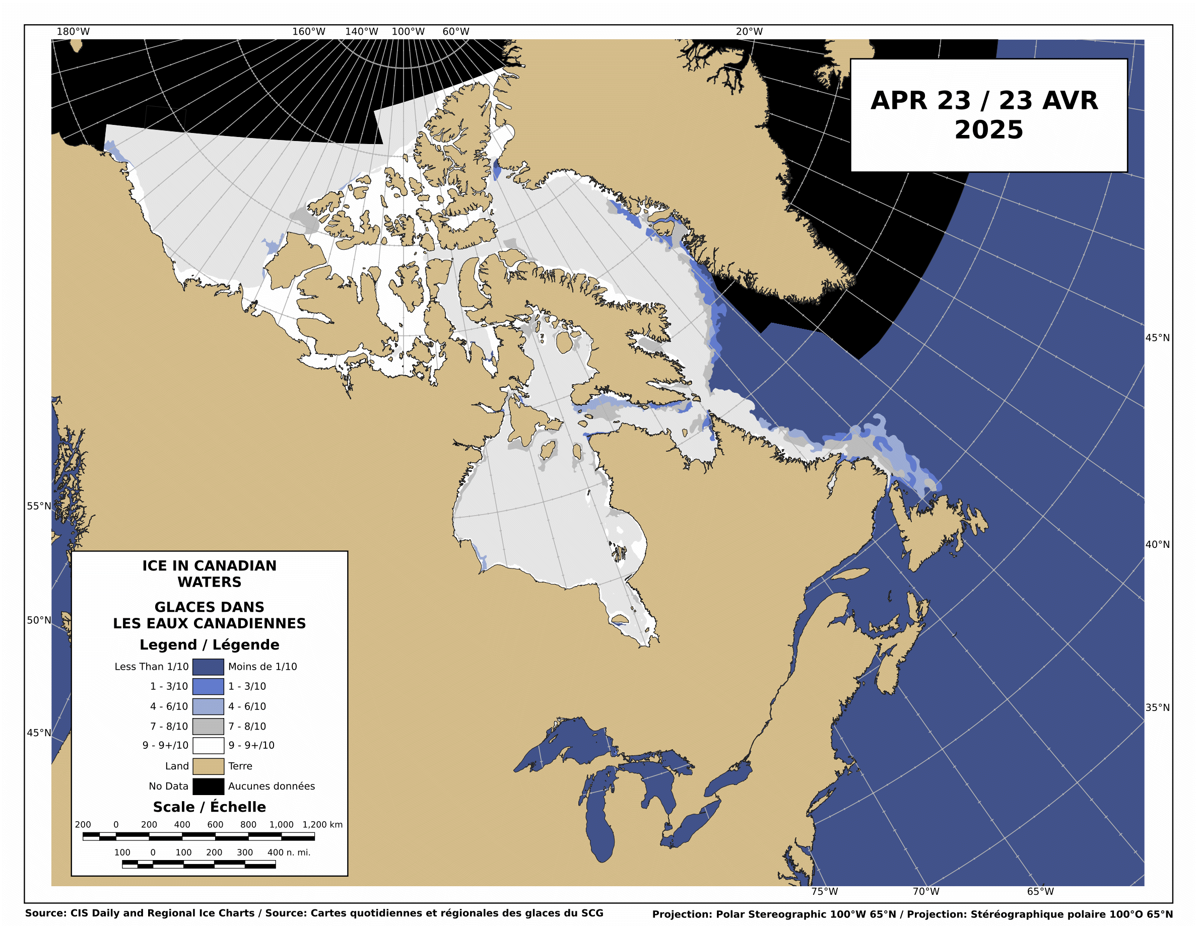
The Canadian Ice Service shows that there is still low-medium concentration ice blocking the Northwest Passage.

http://ice-glaces.ec.gc.ca/Ice_Can/CMMBCTCA.gif
If you owned a ship, would you send it through a route knowing it will face shifting pack ice, possible icebergs, fog, darkness, wind, storms and the possibility of an early freeze?
“The plans that you make can change completely,” he says. This uncertainty, delay, liability, increased insurance and other costs of using the Northwest Passage are likely to deter commercial shipping here. A ship with a reinforced hull could possibly make it intact through the passage. But if it got stuck, it would cost thousands of dollars for an icebreaker like the Amundsen to come to the rescue. So even if the Northwest Passage is less ice-choked than before, the route may not become a shipping short-cut in the near future, as some have predicted.
The Arctic Oscillation was negative for a few days, which allowed colder air to escape from the Arctic and warmer air to invade the Arctic. Note that the period of positive AO starting in early July corresponded to the Moscow heat wave. The cold air was trapped in the Arctic.

The negative dip this week allowed a blast of southerly air to melt and compact the ice during the past week, as we forecast in last week’s sea ice news.
")

http://ocean.dmi.dk/arctic/icecover.uk.php
Ice extent loss has dropped off dramatically in the last few days, as seen in the DMI graph above and the JAXA graph below.

Note that there was little loss in ice extent during 2006, after August 22.

What does the remainder of 2010 hold? Difficult to say. NCEP forecasts freezing temperatures over the broken ice in the Beaufort Sea during the next two weeks.

http://wxmaps.org/pix/temp2.html
If the remainder of the summer follows a path like 2006, 5.5 million is the right number. Another blast of southerly wind during the next few weeks. and it goes below 5.5. All of the ice indexes currently show 2010 ahead of 2008. DMI and NORSEX show it ahead of 2009 as well. JAXA also shows that the ice area curve has flattened. Ice area is always less than extent, and area trends tend to lead extent by a week or two.

There are large areas of low concentration ice which are vulnerable to compaction, spreading or melt.

My forecast remains unchanged. 5.5 million, finishing above 2009 and below 2006. Same as it has been since May.
The video below shows ice movement in the Beaufort Sea this week. Earlier in the week, it was compacting rapidly, now it is slightly expanding.
It all comes down to the temperature and wind over the next few weeks.
PIOMASS forecasts continue to stray further from the mark. Areas in red are places where PIOMASS incorrectly forecast melt. Solid green is the opposite misprediction.

Lindsay and Zhang forecast a minimum of 3.96 million in July.
The modified NSIDC image below shows ice loss during the last week. Mainly in the Beaufort Sea.

The modified NSIDC image below shows ice gain since 2007 in green, loss in red.

I’m not going to make a forecast for the next week, because there aren’t any dominant indicators either way.

rbateman,
I was not saying that *discussion* is non-existent; I was saying that the *pretending* that Amino Acids in Meteorites was talking about was non-existent.
An Inquirer says:
August 22, 2010 at 8:16 pm
To: R. Gates,
You might think that my comment is picky, but I believe that it is misleading to say that you have always been at 4.5 million. I will grant you that 4.5 million is the first and only quantitative # that I have heard from you, but earlier in the season you described your anticipation that the 2010 minimum would be at or in the vicinitiy of the 2007 minimum — without putting a # on it. So 4.3 million is more descriptive of your first guess –and that is when I sent you a note asking whether you would be around in September because that was a brave estimate. You certainly are free to change your estimate, and wise people do change their opinion when “facts change,” but your initial estimate did make an impression on me.
_______
With all due respect, you are wrong. My 4.5 million sq. km. forecast has been well established here on WUWT since at least March of this year. I have never altered it up or down, much like Steve’s 5.5 million sq. km forecast, though I think he put that out there a bit later. I remember one post commenting how disappointing it would be if the extent hit 5.0 million exactly– as that would mean a “tie”. I found this to be very funny.
stevengoddard says:
August 22, 2010 at 8:38 pm
mecago
Look for a significant increase in MYI next year.
* * * * * * * * * * * * * * * * * * * * * * * * * * * * * * * * * * * * * * * * * *
Maybe, maybe not Steve. With all the loop de loops that the complexity of the Arctic ice cap can throw at us I am amazed by the consistency it’s shown in radical thinning and substantial shrinking.
I personally would have expected something like 3 years of shrink/thin then 1 or 2 of expand/thicken or something along those lines. Of course, it would have taken a much longer time to be seasonally ice free. It would also have implied a much lower rise in temperatures.
Nevertheless, note the basic and incontrovertible temperature rise as seen in Roy Spencer’s UAH temperature chart. Note the quick jump in La Nina from late 1995 and El Ninos from 1998 where both jumped about 1/3F over the previous 16-18 years. Furthermore, the warmth tends to double in proportion in that area.
http://www.drroyspencer.com/latest-global-temperatures/
That temperature rise is notgoing away no matter how many “short term ‘trends'” (Read, frivolous fluctuations) go zig and zag. It’s no different than the stock market. You don’t focus on 1, 2 or 3 days of activity but rather on monthly trends. One day in the stock market equals one year of Arctic activity.
The trend Steve, the trend.
I will just add that I have locked into My Favs 9 weather Stations around the Arctic fringes that I moniter everyday….other than the more central Arctic Bouy Temps which hold some promise of a cool down my Temps haven’t seemed to impressive which now is shown by the uptick in temps above 80N…Still keeping hope Alive since the Arctic is the Cold factory that is needed to bring me & Me alikes that white stuff to the West virginia Alpps!..(256 inches to Canaan Valley,WV last year)
Scott says:
August 22, 2010 at 9:09 pm
As to your references to drugs, that’s not even worth addressing.
MY REFERENCE TO DRUGS? It never ceases to amaze me how posters on this and similar sites lose track of their own conversations. It was this guy who started the amusement not I:
William says:
August 22, 2010 at 3:16 pm
Hey Scott,
I don’t know what it is that you’re smoking, but; can I have some please?
To which you responded:
Scott says:
August 22, 2010 at 4:09 pm
William says:
August 22, 2010 at 3:16 pm
Hey Scott,
I don’t know what it is that you’re smoking, but; can I have some please?
Which of my posts appears to be from a drugged up individual?
-Scott
I thus assumed you had the humor and common sense to realize that I was defending myself, with self caricature, from YOU GUYS who first brought up the reference to drugs.
David Gould says:
August 22, 2010 at 9:20 pm
And, yes, it would be a difficult and dangerous trip into the Arctic and – perhaps paradoxically – probably more dangerous with the kinds of ice that is there at the moment rather than solid ice. I wouldn’t take the trip.
I wonder what Happened to that guy in a kayak? It could he ends up in a dangerous situation and will have to be rescued. But I think he’d make his money anyway.
Ohhh, terrible news from the Arctic. Hide the children before watching.
😉
FWIW, there’s a handy map showing the main courses for the Northwest Passages is at
http://en.wikipedia.org/wiki/File:Northwest_passage.jpg . Might be good for a future post on them when there are several boats stuck along the way or in port.
Galvanize says:
August 22, 2010 at 8:49 pm
Mecago,
My apologies for being slow, but how does the image you linked to prove that the Arctic will be ice free in twenty years?
* * * * * * * * * * * * * * * * * * * * * * * * * * * * * * * * * * * * * * * * * * * * *
My apologies if I was too sarcastic, but I have a tendency to be biting when I run into certain situations that I’ve encountered in the past and have frustrated me.
That link shows 30 years of ice thickness reduction. It shows dramatic reduction in the green MYI which represents three all the way to ten year old ice. Even when there is a recovery in surface area like 2008 there was loss of ice because of the drastic reduction of that thickest of ice.
Unfortunately, those images only include a statistical average between 1981-2000. The most dramatic effect of this ice loss, is impressed upon us when we take a straight series of four images from 1980 to 2010 representing each decade (I know 2010 is not quite over yet).
It is this inexorable decline in volume as well as the fact that temperatures ARE NOT NOR HAVE THEY EVER BEEN DECLINING that allows for a simple time estimate.
I did not make the prediction, Arctic Experts did. Yet it makes intuitive sense. Far more sense then when the IPCC, notorious for gross underestimations of practically anything, predicted the year 2100. Others, with far more sense but still unable to include all the feedback loops, predicted 2050 then 2040.
This brought out the joke, amongst those trying to making the prediction, that the only thing they could accurately estimate is that they would underestimate.
Of course, there is more involved in making these predictions than the ice thickness images I provided, but that is a good start. Roy Spencer’s satellite temperature chart, linked below, should also help in ascertaining what the temperatures are not likely to do.
Just take a look at the last three La Ninas (Down curves-our cool phases) from late 1995 to shortly before this year. They are much warmer than the ones from 1979-1995 as well as the El Ninos of 1998 onward compared to the previous ones going back to 1979.
http://www.drroyspencer.com/latest-global-temperatures/
Any ways, I apologize again for my sarcasm.
Amino Acids in Meteorites says:
August 22, 2010 at 8:04 pm said
David Gould
You’ll have to link the satellite image that shows it open. Cryosphere Today does not show it open. There is not good enough detail. So are you meaning a different image? Canadian Ice Service from today shows it blocked in 4 places.
____________________________________
No, the Canadian ice service does not show it blocked, it shows 4-6th ice coverage in a couple of places, this does not mean it is blocked. Someone provided the link to the modis image from a few days ago and you can see this clearly
http://rapidfire.sci.gsfc.nasa.gov/subsets/?mosaic=Arctic.2010229.terra.1km
So your statements it is blocked is incorrect. It might be more difficult than no ice, and more dangerous, but it is not unnavigable.
Andy
Amino Acids in Meteorites says:
August 22, 2010 at 10:00 pm
Ohhh, terrible news from the Arctic. Hide the children before watching.
😉
—
LOL! Thanks, AAM, that always makes me grin, thinking about the Arctic Death Spiral!
AndyW
Ice moves continuously in the wind. Any ship running through the NWP is at risk of hitting the ice, particularly in darkness and/or fog.
stevengoddard says:
August 22, 2010 at 11:13 pm
AndyW
“Ice moves continuously in the wind. Any ship running through the NWP is at risk of hitting the ice, particularly in darkness and/or fog.”
* * * * * * * * * * * * * * * * * * * * * * * * * * * * * * * * *
Steve, it’s obvious that it’s dangerous for certain vessels and the inexperienced to rashly go. Yet, there are others who know what they’re doing.
The whole point of the Northwest Passage being open this early is that it will be safer a couple of weeks from now. If you still hesitate to accept that, there remains the obvious implications for the future (Time for Mr. Trend to hold hands with Ms. Big Picture.). Which implications are . . .?
http://movieclips.com/watch/the-wizard-of-oz-1939/im-melting/
Although northern-sea-ice related, this is definitely off-topic, as it deals with “olds” rather than “news”.
I have noticed a graph in Cryosphere Today which shows seasonal northern hemisphere sea ice extent since 1900. What brings my attention is not the end point (the graph has not been updated since summer 2008), but the fact that it has information on sea ice extent since 1900. The satellite measurements started in 1979.
Even more important, if you draw a line in 1979, it seems that the summer sea ice extent had already dropped 2 millon square kilometers by the time satellite measurements began, with respect to the 1900-1950 average.
I definitely don’t buy it. But I am curious about how the h*ll they have calculated average summer sea ice extent for the years 1900-1950. Does anybody know?
Cassandra King says: “Try dropping an ice cube into water cooled to one degree C and see how long the ice cube takes to melt, then try to do the same with water cooled to 2 degrees C and note how long the ice cube takes to melt. The water is 100% warmer but . . .”
John F. Hultquist says: “While I agree with the argument you make in the comment, the statement quoted is not correct because C is an interval, not a ratio scale. Convert the two numbers you have chosen (1 & 2) to the F scale and you will get a different answer. K, a ratio scale, gives a very different answer that is what you need, but it is no way near 100%.”
It’s conventional to compute enthalpy relative to water at 0°C. Thus the enthalpy of water at 2°C is twice that of 1°C, i.e., has 100% more heat. The important thing when doing ice-melting calculations (in liquid media) is the dT between the ice and the water. Cassandra King is correct.
CRS, Dr.P.H. says:
August 22, 2010 at 11:12 pm
LOL! Thanks, AAM, that always makes me grin, thinking about the Arctic Death Spiral!
* * * * * * * * * * * * * * * *
Spirals start slowly, you know. Then they pick up speed. Eventually, the vortex swallows everything.
How old are you, by the way? See you in 20 years.
Nylo says:
August 23, 2010 at 12:03 am
I definitely don’t buy it. But I am curious about how the h*ll they have calculated average summer sea ice extent for the years 1900-1950. Does anybody know?
* * * * * * * * * * * * * * * * * * * * * * * *
I could give it an educated guess. Probably the same way they count the stars in our galaxy, even nowadays with advanced technology. They take a multitude of different small segments throughout the expanse of the galaxy(Sea?) and count there. The other 99.999999+% that remains uncounted, is surmised through statistical averages.
By the way, our galaxy does have a wide range of star concentration. You would not want this planet to be in the dense core.
“Jarmo says: August 22, 2010 at 11:13 am
“Funny, according to CPC AO running mean, the last two-three months have been positive and have reached value of +2:”
The chart you linked to is “The standardized 3-month running mean value of the AO index”;
http://www.cpc.noaa.gov/products/precip/CWlink/daily_ao_index/month_ao_index.shtml
whereas Steve highlighted the Daily AO Index, which supports his assertion:
http://www.cpc.noaa.gov/products/precip/CWlink/daily_ao_index/ao.sprd2.gif”
Just The Facts, I have no problem with Steve’s assertation. I just took a look at the graphs and wondered how AO running mean can show such a high value (+2), when daily AO has not reached +2 during 2010 (as far as I know).
Steve Goddard
Do you know if any sort of study has ever been done on the effects of using modern ice breaking ships on extent/thickness of ice? This must be especially relevant in certain places-perhaps including part of the NW passage.
tonyb
The Sarema, a Finnish sailing yacht is now halfway through her journey down the NWP from Alaska. They indicate the ice is melting rapidly as they are about to enter the most difficult part of their journey. They will be able to negotiate ice up to 3/10 if need be (colours blue and green on the Canadian map).
http://northwestpassage2010.blogspot.com/
Nylo
I wrote an article on Historic variations in sea ice (something that happens with surprising regularity throughout history)
http://wattsupwiththat.com/2009/06/20/historic-variation-in-arctic-ice/
Towards the end of that article are a series of references concerning measured extent-some going back to 1860. I take modern measurements with a very large pinch of salt so would not vouch for the accuracty of the older ones, but they are ceretainly interesting
tonyb
There is a “barycentric” hypothesis that states that the climate is influenced by oscillation of the solar system “centre of gravity” due to planetary alignment and the influence of this on the sun. A recent paper on this:
http://meetingorganizer.copernicus.org/EGU2010/EGU2010-9559.pdf
includes the quote:
Ian Wilson et al. (2008) presented evidence that claimed that changes in the Sun’s equatorial rotation rate are synchronized with changes in the Sun’s orbital motion about the barycentre of the Solar System. This paper showed that the recent maximum asymmetries in the Solar motion about the barycentre have occurred in the years 1865, 1900, 1934, 1970 and 2007. These years closely match the points of inflection in the Earth’s LOD.
Its interesting that 2007 is identified as an inflection of LOD (length of day). What causes LOD to change? One probable candidate is polar ice. Increased polar ice moves water mass poleward and closer to the rotation axis, thus faster rotation (as with a spinning ice skater drawing in arms to accelerate rotation).
This is of course speculative but it would be consistent with 2007 being a minimum of polar ice mass.
At least, British s/y Young Larry seems to be missing from the above list of boats sailing the NW passage this year:
http://www.sailblogs.com/member/nw_passage/?xjMsgID=140781
Ariel 4 from Sweden sailing in the same direction:
http://www.arielfyra.se/blogg/
tonyb,
Yes, I am a long time lurker and occasional commenter here and I remember your article very well, a great one. I thought that I had commented on it at the time but I see that I didn’t. It is your article, among other things, that makes me “not buy” the 2M km2 loss that CT pretends us to believe that quickly happened in only 25 years between a supposedly “normal” level shown to be nearly constant between 1900-1950 and that of 1979-onwards.
Scott says:
August 22, 2010 at 6:52 pm
just click on the date & time below the name for the URL (or R-Click & copy)