By Steve Goddard

Darkness is returning to the Arctic as the sun moves towards the horizon. In four weeks, the sun will disappear completely at the North Pole.

Solar Energy as a function of latitude and date
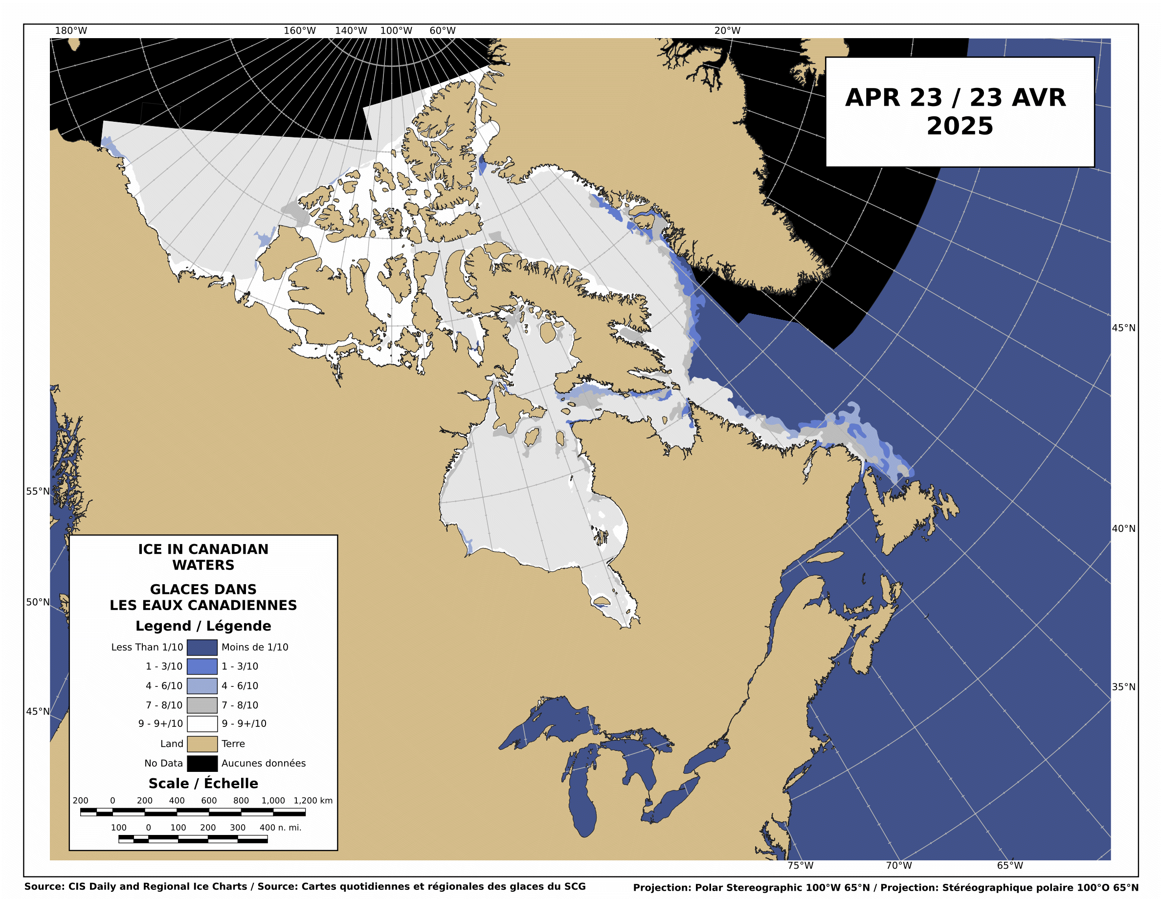
The Canadian Ice Service shows that there is still low-medium concentration ice blocking the Northwest Passage.

http://ice-glaces.ec.gc.ca/Ice_Can/CMMBCTCA.gif
If you owned a ship, would you send it through a route knowing it will face shifting pack ice, possible icebergs, fog, darkness, wind, storms and the possibility of an early freeze?
“The plans that you make can change completely,” he says. This uncertainty, delay, liability, increased insurance and other costs of using the Northwest Passage are likely to deter commercial shipping here. A ship with a reinforced hull could possibly make it intact through the passage. But if it got stuck, it would cost thousands of dollars for an icebreaker like the Amundsen to come to the rescue. So even if the Northwest Passage is less ice-choked than before, the route may not become a shipping short-cut in the near future, as some have predicted.
The Arctic Oscillation was negative for a few days, which allowed colder air to escape from the Arctic and warmer air to invade the Arctic. Note that the period of positive AO starting in early July corresponded to the Moscow heat wave. The cold air was trapped in the Arctic.

The negative dip this week allowed a blast of southerly air to melt and compact the ice during the past week, as we forecast in last week’s sea ice news.
")

http://ocean.dmi.dk/arctic/icecover.uk.php
Ice extent loss has dropped off dramatically in the last few days, as seen in the DMI graph above and the JAXA graph below.

Note that there was little loss in ice extent during 2006, after August 22.

What does the remainder of 2010 hold? Difficult to say. NCEP forecasts freezing temperatures over the broken ice in the Beaufort Sea during the next two weeks.

http://wxmaps.org/pix/temp2.html
If the remainder of the summer follows a path like 2006, 5.5 million is the right number. Another blast of southerly wind during the next few weeks. and it goes below 5.5. All of the ice indexes currently show 2010 ahead of 2008. DMI and NORSEX show it ahead of 2009 as well. JAXA also shows that the ice area curve has flattened. Ice area is always less than extent, and area trends tend to lead extent by a week or two.

There are large areas of low concentration ice which are vulnerable to compaction, spreading or melt.

My forecast remains unchanged. 5.5 million, finishing above 2009 and below 2006. Same as it has been since May.
The video below shows ice movement in the Beaufort Sea this week. Earlier in the week, it was compacting rapidly, now it is slightly expanding.
It all comes down to the temperature and wind over the next few weeks.
PIOMASS forecasts continue to stray further from the mark. Areas in red are places where PIOMASS incorrectly forecast melt. Solid green is the opposite misprediction.

Lindsay and Zhang forecast a minimum of 3.96 million in July.
The modified NSIDC image below shows ice loss during the last week. Mainly in the Beaufort Sea.

The modified NSIDC image below shows ice gain since 2007 in green, loss in red.

I’m not going to make a forecast for the next week, because there aren’t any dominant indicators either way.

mecago says:
August 22, 2010 at 1:28 pm
From the Trend without End, Amen Dept:
One could have easily made a convincing case that the Bull Stock Market (in 2007) was headed for 20,000 by 2020.
Right up until the week of the Big Bust, it was carefree and endless. Bubbles had popped before, but statistics were carefully crafted and managed, so they thought this time it was different. The warning signs were there, but few could read them, or cared to.
So, like the Investigator, they sailed right into it.
Anomaly Maps:
NOAA Arctic http://polar.ncep.noaa.gov/sst/ophi/color_anomaly_NPS_ophi0.png
DMI Arctic http://ocean.dmi.dk/satellite/index.uk.php
Unisys World EXCLUDES ARCTIC http://weather.unisys.com/surface/sst_anom_inv.gif
All 3 Differ ENORMOUSLY. Both Arctic Maps have a VERY HOT Alaska but Unisys is Cold off East Alaska.
Note Unisys’s MAP projection makes this area appear Huge but the Map edge is SOUTH of the Beaufort Sea Ice.
Spitzbergen has a +8oC blob in NOAA North of where an off-Norway Cold Spot is in Unisys (but all 3 do agree on THAT, the 2 that continue North of the Arctic Circle, show it gets Warmer to the North of that()
DMI has a BIG hot spot where 2007’s was, at the New Siberian Islands (East Central Siberia) where NOAA is only a bit Warm.
NOAA has a HOT area West of Novaya Zemlya – – DMI is BELOW NORMAL there ! (N.Z. is the extension of the Urals that divide Siberia & Europe).
.. And NONE of them go back much (DMI a month). TOPAZ went back into 2008, but ALL the Northern (Roos, Nansen, Topaz) sites are either Down or I cannot load them.
Another:
#4 Global, but Arctic squeezed =hard to see:
– – mostly COLD. Except Alaska. And off Norway, where it is the ONLY Warm one of the 4:
http://www.weatherzone.com.au/climate/indicator_sst.jsp?lt=global&lc=global&c=ssta
I would assume the 2 that Specialize in the Arctic are best at it – – & they do track together (if an off-scale +8 oC spot for one, may find the other at just +2)
mecago says:
August 22, 2010 at 1:28 pm
[emphasis mine]
The only thing I’ve seen in this thread that seems “magical” is your prediction of how the “ice free” summers are going to progress 10-20 years from now. Did you see it in a crystal ball?
-Scott
fishnski says:
August 22, 2010 at 2:02 pm
Are you just joking around or do you know someone who works with the data analysis that told you almost no ice loss is happening today? I’m always interested to get the newest results ASAP.
-Scott
Hey Scott,
I don’t know what it is that you’re smoking, but; can I have some please?
miket
Looked to me like Fulham deserved the win.
Cassandra King says:
August 22, 2010 at 11:41 am
“Try dropping an ice cube into water cooled to one degree C and see how long the ice cube takes to melt, then try to do the same with water cooled to 2 degrees C and note how long the ice cube takes to melt. The water is 100% warmer but . . .”
While I agree with the argument you make in the comment, the statement quoted is not correct because C is an interval, not a ratio scale. Convert the two numbers you have chosen (1 & 2) to the F scale and you will get a different answer. K, a ratio scale, gives a very different answer that is what you need, but it is no way near 100%.
Amino Acids in Meteorites says:
August 22, 2010 at 1:54 pm
“The Northwest Passage is not open at just the McClure Straits but a 3 other locations”
I don’t find the maps at this resolution good enough to answer this qustion:
Is the NW Passage open completely from one end to the other?
Your comment implies that it is not.
R. Gates, both daily absolute temps and temp anomalies are data, not information, IE not cause and effect, not correlation, and not mechanism. So I heartily disagree with you that anomalies are all that matter. If that were truly the case all the climatologists, along with all the journals they publish in need to get another job, and Anthony needs to re-assign his web page to something like, I don’t know, fashion changes over the years?
When looking at long term climate trends, I accept anomalies as a reasonable measure of what’s been happening. However, when you talk about a possible “tipping point” then you need to use temperatures.
The ideal would be to give the anomaly and and the base that anomaly is from. eg. A +1C anomaly over a base temperature of -5C. That shows that the temperature is above ‘normal’, but also shows that despite that the temperature is still well below freezing. In the example above, it’s when the anomaly is approaching +5C that we need to b e worried. If it stays less than +3C then it’s not really a significant concern.
Matthew Bergin says:
“They might find it a little harder to travel the passage if it was 1906 and they were doing it without any modern navigation technology. I don’t think the area was even mapped back then.”
Of course there were maps. They were made with dog sleds.
In the summer!
Oh and the 1903 expedition finished in 1906.
But, of course, it’s all normal today isn’t it?
William says:
August 22, 2010 at 3:16 pm
Which of my posts appears to be from a drugged up individual?
-Scott
a reader says:
August 22, 2010 at 2:13 pm
Some interesting info about the NW passage from Vilhjalmur Stefansson’s 1947 book “Great Adventures and Explorations” page 537 and onwards–
He describes how during the 2nd and 3rd decades of the 20th century the Hudson Bay Company had greatly expanded its trading posts in the Arctic which required the RCMP to also establish outposts both along the mainland and as far afield as Victoria and King William islands. He says this “necessitated the development of shipping along the Northwest Passage.” To service their outposts they sent one ship from the Atlantic side and one from the Pacific side which met at the Bellot Straits at Fort Ross, then each returning by the way it had come.
So to me it sounds like the NWP was actually navigated many times and regularly so prior to actually being navigated all the way through in one trip by the St. Roch. I would love to hear more about the HBC resupply trips from anyone who has studied this. TonyB?
This happened in 1937 (and possibly 1938) when the Aklavik, based in Cambridge Bay, undertook this journey and met the Nascopie which reached the east end of the Bellot strait from the east. In subsequent years this was not possible and the station at Fort Ross on Bellot was abandoned. Note that these were travels within the NWP not traverses of the whole NWP.
It is not enough to ask “is the NWP open?” You have to also include information about the equipment.
It is one thing to attempt a passage with modern navigational equipment, satellites, radar etc.
It is an entirely different matter to attempt a passage in a wooden boat in fog with 30 foot visibility at night, having no idea what you are facing in the way of ice, or how it may have shifted.
A few days from now is when 2008 took it’s dip. If this year doesn’t follow that then it looks like it will end near the JAXA average.
An important factor to the minimum ice extent is the date that refreeze starts exceeding melt. The sooner it happens, the higher the minimum. In a comment on last week’s sea-ice news #18 http://wattsupwiththat.com/2010/08/15/sea-ice-news-18/#comment-458213 I pointed out that the date of the minimum seems to occur a bit over a week earlier in even-numbered years than in odd-numbered years, using IARC-JAXA data.
I also notice that an even-numbered year always seems to have an earlier minimum-date than the preceeding odd-numbered year…
2003 Sep 18 => 2004 Sep 11
2005 Sep 22 => 2006 Sep 14
2007 Sep 24 => 2008 Sep 09
Note that 2007 was a “double-dip” minimum. There was a local minimum at Sep 16. You can optionally use that date if you want to be conservative. Sep 24 makes the trend even more powerful, but Sep 16 makes it more consistant, i.e. almost exactly a week.
The obvious question is… 2009 Sep 13 => 2010 Sep ??
The above pattern indicates that the 2010 minimum should occur around Labour Day, i.e. September 6th. I’m in a position similar to Livingston and Penn. This is “merely a statistical approach”, and I have no explanation for the underlying drivers. QBO maybe?
Per NSIDC:
“However, today’s conditions in the Northwest Passage would likely astonish 19th century explorers such as McClure, Franklin, and Amundsen. In upcoming decades, the passage will be increasingly likely to open during summer.”
==========================
What does “increasingly likely” mean?
Other than it is likely, that my tax dollars are increasingly needed, to continue fiction written by bad authors.
Talk of the NW passage being “open” is at the same level of importance as climbing Mt. Everest.
Open season is limited.
Hey, here’s a fun-filled idea: Plot the tonnage by year shipped thorough the NW Passage.
Here’s a more recent update on the progress of this season’s Arctic explorers:
http://explorersweb.com/oceans/news.php?id=19590
Looking at the referenced “Solar Energy as a function of latitude and date” it reminded me of a model I built years ago for a set of projects that I can’t talk about. The “customer” was worried about ground observers seeing visual and IR glint of of deployed air vehicles. They needed to know where the sun was at any daylight moment on any day of the year, and the (Az,El) bearing angle to the sun from the ground observer, so that missions could be planned with minimum risk. A colleague suggested we use solar system geometry and I went from there. I checked the modeled predictions against the Farmers’ Almanac for the year I developed the model, and the variance from observed data was minuscule.
It anyone would like to have the”Where is the Sun?” (WITS) model (for free), let me know and I’ll email the source code to you.
Scott:
A thousand apologies to you. That’s what I get from reading too fast. I was referring to the person you quoted as stating that the Arctic would be ice free in 20 years. Again, I’m sorry. I’ll have to be more careful being a wise acre in the future.
stevengoddard says:
August 22, 2010 at 4:21 pm
================================
Steve, you’re exactly right.
You can’t compare the NWP being open now, to being open in the past.
In the past, they didn’t even have a way to know if it was open or not until they got there, just a hunch.
Then they more than likely spent every day just trying to find it.
Before satellites, GPS, radar, even radios, I’m amazed that anyone found it at all.
Now they can look at it ahead of time, have things that tell them 5ft to your port side and you are here, and people are a lot more brave and adventurous, to the point of being reckless and irresponsible, knowing that they can call for help.
Look at all the bozos that have gone up there, in their private boats, because of those reasons.
That does not mean the NWP is “open for the first time”.
It means that people are just as stupid as they have always been.
I don’t get the obsession with hanging on to global warming. It’s not happening. Try to come to terms with that.
John F. Hultquist,
Umm, huh? I don’t follow.
Walter Dnes says:
August 22, 2010 at 5:21 pm
An important factor to the minimum ice extent is the date that refreeze starts exceeding melt. The sooner it happens, the higher the minimum. In a comment on last week’s sea-ice news #18 http://wattsupwiththat.com/2010/08/15/sea-ice-news-18/#comment-458213 I pointed out that the date of the minimum seems to occur a bit over a week earlier in even-numbered years than in odd-numbered years, using IARC-JAXA data.
The Bremen analysis of the same data shows no such variation which is interesting.
http://iup.physik.uni-bremen.de:8084/amsr/ext_rates_n.png