NOTE: This writeup is from an acquaintance of mine who wrote some powerful meteorological software, Digital Atmosphere, that I use in my office. He used that software (and others) to analyze the Air France 447 crash from the meteorological perspective. h/t to Mike Moran – Anthony
by Tim Vasquez
Air France flight 447 (AF447), an Airbus A330 widebody jet, was reported missing in the equatorial Atlantic Ocean in the early morning hours of June 1, 2009. The plane was enroute from Rio de Janeiro (SBGL) to Paris (LFPG). Speculation suggested that the plane may have flown into a thunderstorm. The objective of this study was to isolate the aircraft’s location against high-resolution satellite images from GOES-10 to identify any association with thunderstorm activity. Breakup of a plane at higher altitudes in a thunderstorm is not unprecedented; Northwest Flight 705 in 1963 and more recently Pulkovo Aviation Flight 612 in 2006 are clear examples.
Back in the 1990s I did flight route forecasting for the Air Force. One of my assignments in summer 1994 was forecasting was the sector between Mombasa, Kenya and Cairo, Egypt for C-5 and C-141 aircraft. The Sudan region had tropical MCS activity similar to this with little in the way of sensor data, so this incident holds some special interest for me as one of our C-5s could easily have followed a very similar fate. Using what’s available to me I decided to do a little analysis and see if I could determine anything about the fate of AF447 and maybe through some circuitous, indirect means help give authorities some clues on where to look.
1. Reports and evidence
Reports indicate AF447 reported INTOL (S01 21.7′,W32 49.9′ or -1.362,-32.832) at 0133Z and was to proceed to TASIL (N4 00.3′,W29 59.4′, or +4.005,-29.990) in 50 minutes (a true track of 28.1 deg) (source) indicating that it flew high altitude route UN873 (see below).

Enroute High Altitude Caribbean and South America H-4, 30 AUG 2007 (National Geospatial-Intelligence Agency) |
Though the actual flight plan data was not accessible to me, this corresponds well with an actual flight plan found on the Internet for a Varig B767 from Rio de Janeiro to Frankfurt:
|
I decided to project the flight forward from INTOL. An altitude of FL350 and speed of 520 mph was given. Presumably this is ground speed according to the ACARS specification. Compensating for a 10 kt headwind as given by the SBFN sounding this yields an airspeed of M.80, which correlates well with the A330’s typical early cruise profile. This yields the following aircraft coordinates:
|
2. Meteorological analysis
Surface analysis showed the suspected crash region to be within the intertropical convergence zone (ITCZ), which at this time of year is usually found at about the 5-10N parallel. A region of strong trade winds covered most of the tropical North Atlantic and this kept the ITCZ in a somewhat southerly position. The linear convergence along the ITCZ and the unstable atmospheric conditions combined to produce scattered clusters of thunderstorms.

Surface analysis for 0000Z. (NCEP) |
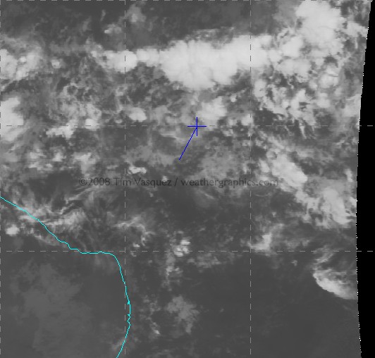
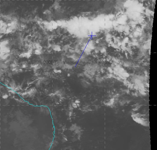
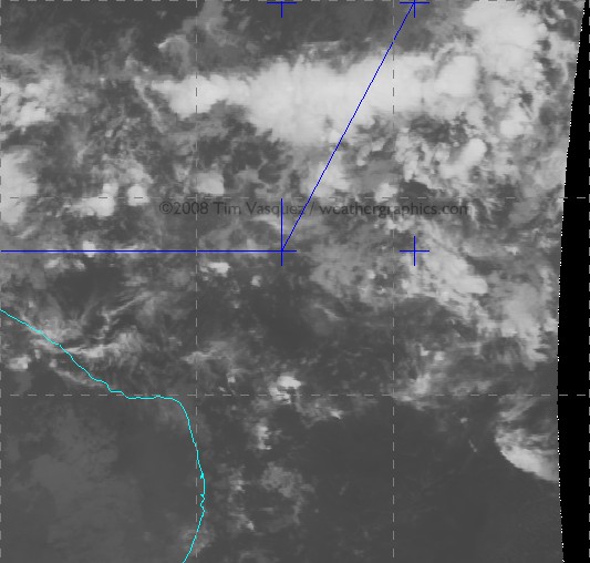
Using McIDAS I acquired satellite GOES-10 satellite data from UCAR and centered it over the region between INTOL and TASIL. I then plotted the waypoints using McIDAS’s built-in coordinate entry panel. Since the source satellite images are georeferenced NOAA/GINI datasets, the points shown here are very accurate and are NOT placed by hand but by lat/long coordinates to the nearest 0.001 deg (0.06 mile). In the image below, the stationary southerly point in blue is INTOL and the aircraft’s estimated location from the above table is marked with a cross. Graticule spacing is 5 degrees. For the orange temperature plots I used the NCL/3aw curve; the sharp gradient of the enhancement from dark to light occurs at 243K (-30 deg C), indicating a cloud top of FL310 assuming the satellite pixel is completely overcast with that layer (which is not always true).
NOTE: If you have trouble seeing some of the large images, the source link is here -Anthony
| Frame Controls | Satellite images |
|---|---|
Loop Mode:
Adjust Speed:
Dwell First/Last:
Frame No: Omit Frame: 1 2 3 4 5 6 7 8 9 |
 |
(Hit reload if you don’t see the satellite images in the looper above)
Raw infrared images are also available here: 0145Z, 0200Z, 0215Z, 0230Z.
And finally this image shows a zoomed image at 0215Z when AF447 made its last transmission:

click for a larger image
About 90% of the cloud material seen on this image is actually multiple levels of convective debris fields from dying storms and activity that occurred previously during the day, with only scattered cirrus fields at flight level. The active thunderstorm areas are defined by small-scale mottled areas of cold cloud tops. Compare with this structural diagram below of a similar tropical MCS in the same area in 1977. It illustrates that planes inflight are clear of most dangerous weather throughout a tropical system except when directly above an active updraft area.

Schematic of a typical tropical MCS observed in the Atlantic southwest of Dakar on 4 Sep 1974. (Structure and Dynamics of a Tropical Squall-Line System, R. A. Houze Jr., Mon. Wea. Rev., 105, 1540-1567) |
It appears AF447 crossed through three key thunderstorm clusters: a small one around 0151Z, a new rapidly growing one at about 0159Z, and finally a large multicell convective system (MCS) around 0205-0216Z. Temperature trends suggested that the entire system was at peak intensity, developing rapidly around 2300-0100Z and finally dissipating around dawn. From a turbulence perspective, these cold spots would be the areas of highest concern as they signal the location of an active updraft producing new cloud material in the upper troposphere.
The last communication from the plane was at 0214Z (12:14 am local meridian time). This was an automated ACARS message reporting an electrical fault and pressurization problem. This would be about the time the plane was beginning to exit the cluster, but not before having flown for 75 miles of numerous updrafts. The exact aircraft location cannot be determined with certainty, however, since a 1-minute time error in position or reporting time translates to 9 miles of spatial error.
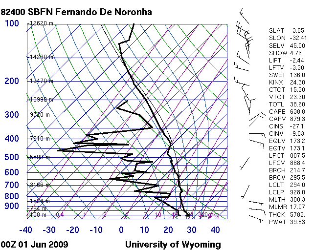
The Fernando de Noronha sounding is available here and shows typical tropical conditions with modest positive energy throughout the column from the surface up to 45,000 ft. There is what looks like anvil level material above 25,000 ft. The significant dry mid-level air is somewhat unusual and suggests the potential for enhanced evaporational cooling in the upper troposphere enhancing downdraft production, and any synoptic-scale lift (if present) enhancing instability through adiabatic cooling of the layer.
I modified this sounding (see below) using the prevailing temperature/dewpoint field across that part of the ocean and modifying for some cooling due to nighttime loss of heating. This is my best guess at the parcel profile that fed this storm. It yields a worst case instability of 1048 J/kg of CAPE, which is moderately strong but considered borderline for typical severe weather. Vertical velocity can be obtained by w=2*CAPE^0.5 yielding a maximum possible updraft speed contribution of 45.8 m/s or 102 mph, though in reality this is usually much less (on the order of half or less) due to precipitation loading and other factors.

3. Conclusions
The satellite imagery indicates that numerous cumulonimbus towers were rising to at least 51,000 ft, and were embedded in extensive stratiform anvils with tops of 35,000 to 45,000 ft. This kind of configuration is actually quite normal for equatorial storms due to the higher tropopause height, but it emphasizes that the aircraft was certainly within the bulk of an extensive cumulonimbus cloud field for a significant amount of time and that storms could indeed have been a contributing factor to the crash.
I’ve edited this section Monday night to cut down on the speculation about the accident chain, especially since I don’t know a whole lot about A330 systems. The airliners.net board and other sites cover the aircraft and CRM systems quite well. What I will try to do, however, is summarize what the aircraft probably encountered based on the data and my own experience.
* Turbulence — Turbulence is a definite candidate as a contributing factor. There is an isolated storm at (1.6,-31.5) that appears suddenly at 0200Z just as the A330 enters the main MCS cluster. From a turbulence perspective it is by far the most dangerous formation found on the loop. However it is 10-25 km to the left of UN873 and it is doubtful the crew would have been deviating at this time. Other cells like this one embedded within the main MCS may have caused severe turbulence. Young updrafts are particularly dangerous to flights because they contain significant rising motion yet precipitation fields have not yet fully developed and airborne radar signatures are weak, reducing the likelihood the crew will deviate around the cell. Another concern is the extensive upper-level dry air shown on the SBFN sounding (not counting the anvil debris at 350-300 mb), which may have contributed to enhanced evaporative cooling in and around the anvil and aggravated the turbulence experienced by the flight, especially around the margins of anvil clouds and towers. It is worth considering that cumulative periods of heavy turbulence crossing through the cluster may have caused minor internal damage that progressed in some way into an emergency.
* Icing — With a flight level temperature of -43 deg C suggested by the proximity sounding the A330 would have been flying mostly in rime ice and possibly some clear ice and graupel. At -43 deg C, water cannot exist even in supercooled form (see here for an explanation). The equivalent potential temperature throughout the profile is absolutely insufficient to bring warmer air with supercooled water to flight level. Without the supercooled water there is very little ice buildup on the airframe. My conclusion is that unless the plane descended below FL300 icing would not be the culprit.
* Lightning — Due to the high cloud tops and freezing level at 16,000 ft, there was extensive precipitation by cold rain process and it is likely the MCS was electrified. Lightning of course being considered with good reason since the A330 is one of the most computerized and automated airliners in service. I will say based on my 25 years of meteorology the storms were almost definitely producing lightning. As far what a strike would do to the A330, I have to leave that to to the avionics experts. Some answers might be found at http://www.airliners.net/aviation-forums/.
* Precipitation — A dual engine flameout due to precipitation or ice ingestion is a noteworthy possibility as has been discussed on other sites (specific to the A330 type too). The precipitable water content in any tropical weather system can run very high. However a rain-induced flameout is not possible because supercooled water cannot exist at the -43C cruise altitude and insufficient equivalent potential temperature exists, even in updraft cores, to bring warmer air beyond a few degrees change to the flight level. Therefore the plane at FL350 was completely within some mixture of rime ice, graupel, or small hail. But again, as the link indicates, even ice poses risks to the engine.
* Hail — I got a few comments about hail. I am not entirely convinced that structural hail damage is a factor, partly because I can’t recall hearing much about large damaging hail at altitude in my experience with equatorial flight operations. This would require strong instability, which I’m not yet sure we have, not only to grow the stones but to loft large hailstones from the embryo “nursery” at FL200-250 up to flight level. A value of 1000 J/kg CAPE is really on the fence but not out of the question. The other problem is the mounting body of evidence (see SPC studies) suggesting well-sheared storms (this profile is poorly sheared) are the ones conducive to structures that support hail growth. Finally, another issue is airborne radars are be highly sensitive to hail because of the very high backscatter values of ice, making evasive action likely, and the “young updrafts” I pointed out earlier as a threat would not have provided the residence times necessary yet to contain hailstones; their main threat would be severe turbulence. I am not sure about the hail hypothesis, but I believe there is a high probability of graupel, small ice pellets, or small hail at FL350 in the storm complex (see Icing above).
Overall what we know for sure is weather was a factor and the flight definitely crossed through a thunderstorm complex. There is a definite correlation of weather with the crash. However the analysis indicates that the weather is not anything particularly exceptional in terms of instability or storm structure. It’s my opinion that tropical storm complexes identical to this one have probably been crossed hundreds of times over the years by other flights without serious incident.
Still, in the main MCS alone, the A330 would have been flying through significant turbulence and thunderstorm activity for about 75 miles (125 km), lasting about 12 minutes of flight time. Of course anything so far is speculation until more evidence comes in, and for all we know the cause of the downing could have been anything from turbulence to coincidental problems like a cargo fire.
My own opinion of the crash cause, as of Monday night, based on the complete lack of a HF radio call and consideration of all of the above, suggests severe turbulence (see the BOAC 911 and BNF 250 tragedies) combining in some unlikely way with CRM/design/maintenance/procedural/other deficiencies to trigger a failure cascade. We can almost certainly count on some unexpected surprises once the CVR is recovered. Until then, all we can do is await the investigation and hope that the world’s flight operations stay safe until AFR447’s lessons are revealed.
The most important point is to find out why there is no radio frequency tracking device on this aeroplane.These days tracking devices are very common even if
Car is lost or stolen can be tracked within seconds.Blackbox is the last hope
Of the scientific explanations of what actually happened but it is pathetic to know that there is no tracking device installed on the black box.
Lighting or sudden electric failure due to any reason is THE REAL CAUSE OF THIS ACCIDENT.
Said pilot was from Air Comet, observing bright lights (not exactly flashes) from 49° W and 7°N. Whatever he saw (probably a meteor breaking up into peaces) was about 2000 km away from the location where AF447 vanished.
http://www.correiobraziliense.com.br/html/sessao_18/2009/06/04/noticia_interna/id_sessao=18&id_noticia=115913/noticia_interna.shtml?
What about this?
Red sprites and blue jets.
1) Could those events have been present then? then…
2) Was the plane in the range? then…
3) What would happen if the red or blue hit the plane?
adoucette,
re: crashes due to structural wing failure: in 1981 a Fokker F28 crashed in the Netherlands after flying into a tornado (http://www.aviacrash.nl/paginas/eindhoven.htm and http://en.wikipedia.org/wiki/NLM_Cityhopper_Flight_431) I seem to remember being told during my study aeronautical engineering that the registered load at the time of right wing breakoff was at 2.28 times the maximum operating load, meaning the safety factor j was in practice 2.28, well above the required safety factor j=1.50
The high altitude stall theory is interesting, but seems to be incomplete. Is there any suggestion that a high altitude stall would actually lead to a breakup of the aicraft at a high altitude?
I wonder if there was a combination here… the computers may not have been programmed to anticipate the stall recovery techniques, and so they could have prevented the pilots from recovering (Airbuses can do that). That would be quite the double-whammy.
Carsten Arnholm, Norway (23:49:03) wrote :
They now say in the radio news that the wreckage found at sea was not from AF447…
Not exactly, a helo picked up a wooden pallet they found in the area, but the plane carried no wooden pallets, so the only piece recovered so far wasn’t from AF 447, but the other pieces, including the fuel slick that were spotted from the air (but not retrieved), were from AF 447.
Arthur
peter (02:24:52) wrote:
it is pathetic to know that there is no tracking device installed on the black box.
Actually the Flight Data Recorder has an attached Underwater Locator Beacon that will transmit a signal for about 30 days.
http://en.wikipedia.org/wiki/Underwater_locator_beacon
The transmitter isn’t that powerful (of necessity, since its battery powered) and thus finding it, even with it broadcasting its location, may still prove difficult if the box is under several miles of water, in mountainous terrain and only its general location is known.
Arthur
Has anyone thought of a meteorite? Odds are one in a squillion … but one day? Or last week.
i am just a journalist but the eschanges above shed more light on this situation than anything i have read in the general press.in my blog entry http://unsilentgeneration.com/2009/06/03/air-france-447-structural-flaws/, i quote from the New Scientist and Canadian Safety board about structural problems and the use of composites.The Canadians focused on the tail in a cuba-canada airbus flight crash.
>>Of the scientific explanations of what actually
>>happened but it is pathetic to know that there is
>>no tracking device installed on the black box.
All black boxes have an underwater pinger. But that may be no use if the box has been damaged or is sitting under 2 miles of water. What is the depth there?
Nuclear sub to join hunt for jet BBC 15:38 GMT, Friday, 5 June 2009 16:38 UK
Times: 5 June French Ministers voiced frustration after the Brazilian forces said they had been mistaken in identifying flotsam collected from the ocean as coming from the Airbus A330 that disappeared in a storm on Monday on a flight from Rio to Paris. They also said that they had mis-identified a fuel slick on the surface.
Can a large jet airliner come down in the ocean and leave no trace whatsoever? If it broke up in flight, there would have been a scattering of floating debris over a wide area. If it dived into the sea, it would have broken up on impact, leaving a local debris field. Only if it successfully ditched on the sea, and sank shortly thereafter, would there have been no trace – except the passengers would have climbed out before it sank.
It makes no sense, except if AF447 was nowhere near its planned flight path, and the search is being conducted in the wrong place. Perhaps the captain changed course to try to avoid thunderstorms? Perhaps the plane was badly damaged, and the captain was heading back towards land? It seems clear that AF447 wasn’t where it was supposed to be.
Boeing and Airbus publish checklists for “flight with unreliable airspeed or attitude indication”. In my airplane (747-400) it is a memory-item checklist; we’re required to memorize it and be able to accomplish it w/o reference to the checklist. AIrbus re-issued the checklist as a CYA. Boeing would have done the same thing.
The media questions surrounding pitot tube icing seem flaky. All jets are required to have independent pitot-tube heat for both pitot systems. More importantly, an ice-blocked pitot tube will not change the indicated airspeed if altitude is not changed. My understanding is that AF447 had not changed flight levels prior to entering CBs. Therefore, the ADIRUs would have thought there was no change in indicated airspeed, not an overspeed as speculated.
I am an active MD-11 pilot.
Meteorologists say that the Air France Flight 447 had entered an unusual storm with 100mph (160km/h) updrafts that sucked water up from the ocean.
Interestingly, given AFR447’s weight and the air temperature at altitude, and very strong updrafts, it is possible for a plane to be going too fast (exceeding max mach) and too slow (below buffet onset speed) at the same time.
That could have caused the conflicting speed readings.
Also, the AFR447 undoubtedly had the latest Future Air Navigation System equipment on board. However, I don’t know if the air traffic services unit serving that airspace had the corresponding ground equipment.
I have written a longer pilot’s eye view of this, but posted it elsewhere to avoid inflicting a word wall on WUWT.
What astonishes me that an aeroplane built with high technology worth
Billions of dollars and all the sophisticated gadgets and gizmos and
YET NO TRACKING CAN BE DONE NEITHER FOR THE PLANE NOR FOR THE BLACK
BOX????????
Only insurances claims worth HUNDREDS OF MILLIONS of dollars to be paid other than PRECIOUS LOSS
OF LIVES??
How does it make sense when a CAMERA AT MARS & MOON CAN SEND PICTURES
BUT NOT A DROWNED AEROPLANE???
In 2007 there was an incident where two paragliders got sucked into a thunderstorm. One survived. The other was found over 40 miles from where he started.
See:
http://www.cbsnews.com/stories/2007/02/16/world/main2486010.shtml
Tim Vasquez
Excellent informative post.
A possible minor refinement is to check the latest speed information. cf
Pilots Saw ‘Fire on Ocean’ Where Jet VanishedFox June 2, 2009
TP
While pitot tubes may be heated, it appears that some models can fail:
Recovery of bodies may refine crash location:
Brazil: 2 bodies found near jet crash siteAP June 6, 2009
idlex (12:02:47) :
. . . Can a large jet airliner come down in the ocean and leave no trace whatsoever?
No. There’s flotsam out there, but even knowing the approximate area, the ocean is big. Very big. Most metal bits would sink, so that limits search aircraft radar ability, and few ships were in the area. That’s changing. They just haven’t found it yet.
French weather service says IR satellite shows T-storms, but not of unusual intensity. BBC says the aircraft sent 28 automatic maintenance fault reports before it went down.
Ken Hall (14:51:58) ‘s idea of a meteorite strike is ridiculous. But it does fit. A hit on the right part of the plane would produce all the symptoms we’ve heard of, just as much as a missile strike would. During a pre-dawn turning climbout back in my AF days, I saw one shoot straight down two or three miles away, so it’s not impossible. Only finding kryptonite traces in the wreckage could confirm something that unlikely, though.
peter (00:27:13) :
What astonishes me that an aeroplane built with high technology worth
Billions of dollars and all the sophisticated gadgets and gizmos and
YET NO TRACKING CAN BE DONE NEITHER FOR THE PLANE NOR FOR THE BLACK
BOX????????
Only insurances claims worth HUNDREDS OF MILLIONS of dollars to be paid other than PRECIOUS LOSS
OF LIVES??
How does it make sense when a CAMERA AT MARS & MOON CAN SEND PICTURES
BUT NOT A DROWNED AEROPLANE???
Radio waves don’t propagate through water (particularly sea water) if the crash had been on land the EPIRB would have been detected by satellite (406 MHz).
What my point is that there must be PROPER TRACKING of allthe aeroplanes.
At least the Route taken by aeroplane and LAST POINT OF CONTACT should
Be mapped with Satellite charting.
Now a days Satellite can read car licence plate BUT IT IS FOOLISH TO SEE
HOW COME AN AEROPLANE LOADED WITH 228 PASSENGERS GONE MISSING
AND DAYS AND DAYS PASSED WITHOUT ANY TRACE >>??
If a ship goes down beaconed life-boats pop off and automatically inflate. Surely aircraft have similar systems??
Sandy (13:59:11) :
“If a ship goes down beaconed life-boats pop off and automatically inflate. Surely aircraft have similar systems??”
Aircraft frequently fly over water and, sometimes land in water (Hudson River landing).
It puzzles me why aircraft parts,wings especially but also tailplane structures and the lower section of fuselage bodies are not built with foam inserts so that they float.
I realise that it would take up room but would stop aircraft from sinking to the bottom of wherever it did its watery landing. A larger break-up would yield many floating parts.
RPT-Timeline of Airbus speed data problems Reuters June 7, 2009
So now it looks like the plane did NOT break up at altitude at all. A high altitude stall seems to have been what happened, and then a combination of pilot error and misprogramming of the “computer-knows-best” Airbus systems could have foiled stall recovery (no programmer can anticipate all possible combinations). Also wouldn’t surprise me at all if the pilots decided not to trust *any* of their instruments, and in white-out conditions, flew the bird all the way down. Lots of planes go down in white-out conditions when the pilot decides the instruments are lying to him.
And voila. Airplane in the drink. It breaks up on or near the surface.
I *really* hope they find the black box. My money is that the fault is on BOTH the pilot and the computer.