Old Radar Sites In Greenland Show Icecap Growth Over the Years
(And let’s not forget what we’ve learned about the temperature reporting from the DEW line Radar Stations – Anthony)
By Joseph D’Aleo, CCM, AMS Fellow
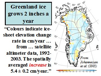
Though the ice may be melting around the edges of the Greenland Icecap in recent years during the warm mode of the AMO much as it did during the last warm phase in the 1930s to 1950s, snow and ice levels continue to rise in most of the interior. Johannessen in 2005 estimated an annual net increase of ice by 2 inches a year.

(Above: Recent Ice-Sheet Growth in the Interior of Greenland, Ola M. Johannessen, Kirill Khvorostovsky, Martin W. Miles, Leonid P. Bobylev, Science Express on 20 October 2005 Science 11 November 2005: Vol. 310. no. 5750, pp. 1013 � 1016, DOI: 10.1126/science.1115356)
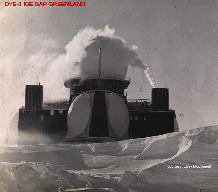
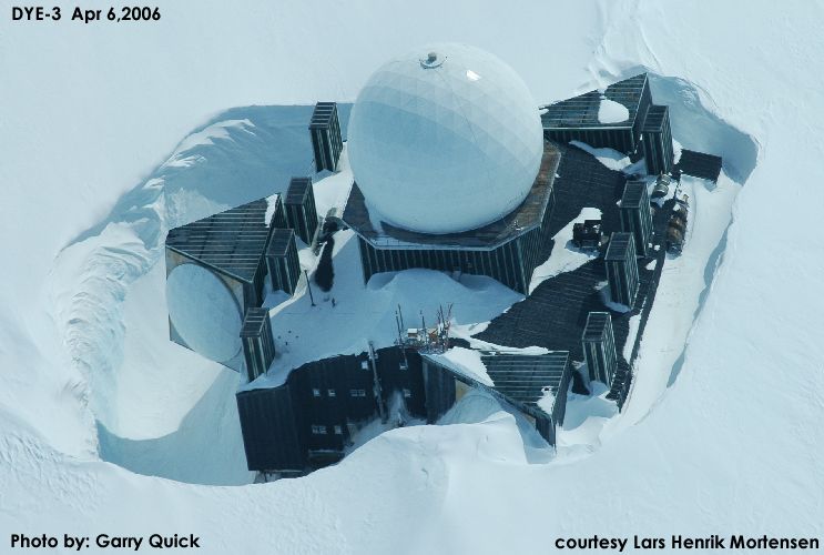
A Canadian Icecap emailer noted during the cold war there were two massive radar sites built on the Greenland icecap now abandoned. They are called Dye-2 and Dye-3. When built they sat high above the snow, recent pictures show how the snow is building up around them, proving the snow build-up in recent times. This demonstrates this snow accumulation over time.
Dye-2 and 3 were among 58 Distance Early Warning Line radar stations built by America between 1955-1960 across Alaska, Canada, Greenland and Iceland at a cost of billions of dollars. Their powerful radars monitored the skies constantly in case Russia decided to send bombers towards America. After extensive studies in late 1957, the USAF selected sites for two radar stations on the ice cap in southern Greenland. Dye-2 was to be built approximately 100 miles east of Sondrestrom AB and 90 miles south of the Arctic Circle at an altitude of 7, 600 feet, and Dye-3 was to be located approximately 100 miles east of DYE II and slightly south at an elevation of 8,600 feet.
The selected locations for the new radar sites were found to receive from three to four feet of snow fall each year. Since the winds were constantly blowing with speeds as much as 100 mph, this snow accumulation constantly formed large drifts. To overcome this potential problem, it was decided that the Dye sites should be elevated approximately twenty feet above the surface of the ice cap.
Dye 3 was built in 1960. From a distance the structure, with its onion-shaped dome, looks like a Russian orthodox church. Dye 3 was an ice core site and previously part of the DEW line in Greenland. (The Distant Early Warning (DEW) Line: A Bibliography and Documentary Resource List Arctic Institute of North America, Page 23). As a Distant Early Warning line base, it was disbanded in years 1990/1991. The Dye 3 cores were part of the GISP (Greenland Ice Sheet Project initiated in 1971) and, at 2037 meters, was the deepest of the 20 ice cores recovered from the Greenland ice sheet as part of GISP. Samples from the base of the 2km deep Dye 3 and the 3km deep GRIP cores revealed that high-altitude southern Greenland has been inhabited by a diverse array of conifer trees and insects within the past million years. (Eske Willerslev, et al. (2007) Ancient Biomolecules from Deep Ice Cores Reveal a Forested Southern Greenland Science 317 111-114)
The first image below is from 1972.

See larger image here.
Here it is in 2006.

See larger image here.
In looking back at the time the sites were abandoned, one console operator lamented “We were very busy during this time and I was sad to see it end. I remember thinking of all the waste,” he said. The site is slowly disappearing into the snow. Its outbuildings are no longer visible and drifting snow will consume it completely one day, but that day appears to be decades away.” Read more here.
Old construction worker
Hopefully this link goes direct to the page. It is an interesting article and worth reading.
tonyb
http://hallolinden-db.de/baseportal?htx=/hallolinden-db.de/Klima/Klima&cmd=list&range=900,100&Datum==*&cmd=all&Id=1680
Philincalifornia
Consider going up the hill from where you are to the Lawrence Hall of Science, just above UC Berkeley. They have a computer console display of the sea level changes in the vicinity of San Francisco over the last 10,000 years. You’ll note that 10,000 years ago the shoreline was out where the Farralon Islands are today. There was no SF Bay. Since about then the sea level rose about 120 meters and stabilized about 7,000 years ago. 7,000 years ago marks the beginning of the urbanic civilizations we know of today. Before then the sea level rise was too great for coastal urban areas to develop. There hasn’t been much sea level variation since then even though we’ve had major periods of warmth as well as cold.
Hi. I am actually trying to reach the main blogger but I am not smart enough to figure out how. I would be grateful if you forwarded.
I am a skeptic with an open mind. I live in California. I would like to find out how to distinguish between alleged global warming, caused in part by human activities and the periodic La Nina, which much predates the industrial revolution and cars.
Thank you.
jdelacroixliberty@gmail.com
jacquesdelacroixliberty.wordpress.com
TonyB
Thanks for the help. The link only goes to the index page. You still need the scroll down to the title (THE GREENLAND-ANTARCTICA MELTING PROBLEM DOES NOT EXIST) and open article.
STEPHEN H. SCHNEIDER seems not to agree:
An interesting quote from Steven H. Schneider:
May I translate? Thank you:
“Lying is an appropriate tactic to further the AGW agenda.”
This article does not help the growing resistance against “the climate crises folk.” It is too easy to challenge. Please be careful what you write so as to not discredit the cause.
There’s an interesting pdf (the link is on the page) on Greenland’s history during the last interglacial (Eemian):
http://www.agu.org/pubs/sample_articles/cr/2001JB001731/index.html
Their studies suggest Greenland’s icecap was less than half the volume then as today.
Old construction worker
You are right-still it is a good article so I hope people will take the trouble to open the link
TonyB
WW II Aircraft lost on Greenland
The two most notable aircraft losses on Greenland back in the 1940’s were
1)the B-17/P-38 flight which crashed in 1942 in southeast Greenland 17 miles from the coast (google P-38 Glacier Girl) later found buried and recovered piece by piece from over 260 ft of ice and…
2) B-29 ‘Kee Bird’ that went down in 1947 in NW Greenland north of Thule. This aircraft was found in the 1990s and was still at the ‘surface’ with little snow around it. Darryl Geenamyer and a crew attempted to resore the B-29 on site and fly it out. When they were taxying the plane on the ice, after the restoration, while bumping over some snow drifts, a running APU (Auxilliary Power Unit) in the tail broke lose, caught fire and wound up destroying the plane on the ice 🙁
Question – with two separate events happening at around the same time (1940s) yet later found at around the same time (1990s) in very different circumstances (P-38 in deep ice, B-29 at surface)…why???
Reguards,
Jeff K
Carlo (03:58:21) :
Greenland appears to be floating upwards – its landmass is rising up to 4 centimetres each year, scientists reveal.
And the large country’s new-found buoyancy is a symptom of Greenland’s shrinking ice cap, they add.
How can they possibly know the cause? They have perfect knowledge of the plate tectonics under Greenland?
They have also found that the rate of rise has dramatically accelerated in recent years
Anyone who thinks they can determine a trend in a geologic time scale event from a few years data is is is … words escape me. Certainly not a very good mathematician and a worse geologist. I live in shaky California and things move a lot, then don’t, then sometimes a whole lot, then nothing. Yellowstone breaths in and out. The lake tilts, then doesn’t. And they think that they can attribute causality from a few years movement?
Smokey,
I came up with a different translation, to wit:
I am a lying scumbag, and I believe that every other “scientist” should lie through his/her teeth even if they have reasonable doubts.
Mike
philincalifornia (10:09:43) :
http://www.bcdc.ca.gov/planning/climate_change/SLR_strategy.pdf
These people, who appear to be looking at practical approaches to conservation of the Bay (as opposed to the carbon swearbox approach) quote a rise in the Bay water levels of 7 inches between 1900 and 2000.
Which really is meaningless. At the same time, the actual bay has shrunk due to dumping fill in some areas and natural deposition in others. Alviso was a seaport where ships were built for WWII. It is now substantially landlocked. The sports docks have turned from occupied (about 25 years ago when I was looking for a place to put my boat) to now being a reed filled marshy mud flat. Shortly it will be dry land. One can no longer launch a boat from the ramp due to the dirt & mud making it hard to row…
(Alviso is the very southern most tip of the S.F. bay)
Where did all that bay rise go? Swallowed by the earth rise I guess …
My boat was great for the bay. It was a 27′ motor sailer with about 27 inches of draft! Skidded sideways like crazy on a tack, but it was great fun to sale outside the channels around folks stuck in the mud with their fin keels. Much of SF and San Pablo (the north 1/2 of “SF bay”) bays are very shallow. Mostly under 10 feet, often under 3 feet. SF bay is really just a fat river with a very shallow flood plane on each side. The biggest risk to SF bay is not water rise, it’s the sedimentation turning it into a river…
crosspatch (11:42:38) :
[… whole bunch of stuff I agree with]
But overall, glacial periods are becoming longer. The “normal” state of the system is glaciation with “interglacial” warm periods a temporary state.
While that has been true for most of this ice epoch, there is an argument to be made that we are exiting the ice epoch and glaciation will start to reduce. Please see the page at: http://www.sciencebits.com/ice-ages
About 1/2 way down is a chart with our position relative to the spiral arms of the galaxy over time and ice epochs over time. All of our recent glaciations have been in the last (left most) ice epoch. Notice the tight correlation of epochs with arm transits? Milankovitch cycles determine the entrance and exit from glaciations inside an epoch, but the ice epochs are a larger cycle driven by arm transits. We are probably as bad as it gets for cold in this epoch (or close to it) in either the last or next glaciation.
The good news is that we’ve just exited a spiral arm and ought to be heading toward warmer times. The bad news is that ice epochs lag the arm transit and all this is measured in 100s of millions of years; so we could be ‘right on the top’ of the present ice epoch (more glaciations to come but milder) or could have a bit more increase in the strength of the next glaciation or two before we are on the downhill side. (What’s .1 or .2 million years on a 10 million per tick graph 😉 Basically, we need more understanding of this process and a finer grained chart to get some kind of clue what happens next (in a few hundred thousand years).
bedrock in Northern Canada that will be under a mile of ice for 100,000 years starting at some point in the not too distant future.
Interesting idea, but ‘not too distant’ could be 10,000 years. Waste is 1/2 decayed by then and 10 civilizations will have come and gone.
My favorite disposal idea is vitrified canisters deposited in a subduction zone. Comes back a long time later after a near mantel experience diluted with magma… Don’t know how hard it would be to drill a hole into 5 miles of ocean and seabed sediment to place the canisters, though 😉
But I’d really rather not treat fuel rods as ‘waste’. Most of the energy value is still in them. Send the used wash cloths and bunny suits, the coolant pumps and other low level wastes to storage, but turn those fuel rods into new fuel.
And since the switch to glaciation appears to happen quite rapidly we need to have at least some idea of what we are going to do to help our citizens in Alaska and our neighbors in Canada when climate shifts suddenly and their land becomes uninhabitable.
They can join us in Mexifornia and Texico … Seriously, I’d expect the southern US to become part of Mexico as everyone huddles up close and heads for warmth. If an ice age happens, the chaos will make our present idea of “countries” a quaint memory. Then again, in a hundred years we will all be speaking Spanglish anyway and having tacos with our tea & scones.
(My BF as a kid was a Mexican neighbor. I grew up eating tacos at his home and he drinks tea with his pinky out thanks to meals at my home. Yeah, I guess I started it all… ;-0 and we both speak both languages.)
The nice thing is that while the entry is somewhat abrupt, the slope is spread over a long time to the bottom, so we’ve got a few thousand years before it gets really really bad. See
http://en.wikipedia.org/wiki/File:Ice_Age_Temperature.png
Notice how the ice volume builds over about 100,000 years? It takes 1,000 years just to get started. Lets just say I’m not worried about an ice sheet in my or my grandkids lifetimes. Cold, yes, ice, no.
As we are entering a period of orbital shape that is increasingly favorable to glaciation, it might take only one deep solar minimum to trigger the switch.
It looks to me like a stochastic resonance problem. There is just a lot of slop in the exact entrances and exits. It’s not just a solar minimum, it’s also rock falls from space and volcanos and continental drift and ocean currents that could trigger an entrance.
We do know that we’re likely near the end of this interglacial. We just don’t know if the start of the next glaciation is 20,000 years in the future or if it already started 500 years ago and the present is a last gasp counter oscillation on the way down. It could also be that the GHG theory is ‘spot on’ and it is the only thing keeping the ice age away (in which case, please keep burning that coal !!!)
If the Little Ice Age were to repeat today, we might not come out of it. And if we do, and if it happens again 200 years from now, we would stand an even better chance of not coming out of it as the orbit will be even more favorable to glaciation than it is now.
Yup. Unfortunately, there is a great range of possible start dates.
http://en.wikipedia.org/wiki/Milankovitch_cycles
gives a decent treatment. Notice way down at the bottom they site two sources for ‘where we are now’. One saying cooling started 6k years ago, another saying we’ve got about 50,000 years of no worries.
So many words to say “we don’t know.” Sigh.
The good news is that it’s all in geologic time. The next glacial period could have begun in 1500 A.D. and we’ll find out for sure in about 3000 A.D. Yes, it’s that slow, and with 1500 year climate cycles built on top of it.
So I wouldn’t worry about it. Even if the next glaciation already started, it will take 10 lifetimes to become ‘an issue’. That is ‘quite rapidly’ in geologic time…
“” Jeff K (13:04:44) :
WW II Aircraft lost on Greenland
The two most notable aircraft losses on Greenland back in the 1940’s were
1)the B-17/P-38 flight which crashed in 1942 in southeast Greenland 17 miles from the coast (google P-38 Glacier Girl) later found buried and recovered piece by piece from over 260 ft of ice and… “”
Jeff; I had forgotten that illfated Darryl Greenameyer B-29 project. Airplane buffs (me included) were totally stunned by that very sad loss.
But your point ois very important.
A criticism often levelled at the “lost squadron” event was the suggestion that the planes simply sank into the ice. Remember the high school science experiment where a wire cuts its way through an ice cube as a result of the pressure under the wire raising the melting point. The ice melts under the wire, and the water flows around the wire and refreezes.
So they aregued that over sixty years the planes cut their way down.
Well Greenameyer;s B-29 nproves that the planes didn’t cut through the ice. The B-29, was actually on a forzen lake I believe to it wouldn’t have to cut very far to end up in the water.
In fact if the B-17s and P-38s had sunk into the ice, they very soon would have been buoyant, and the pressure wouldn’t be anywhere near high enough to cause melting. Also the ambient temperature was likely way to cold to permit melting at any achievable pressure.
So those planes were buried in snow, which slowly compacted. Now one atmospher pressure of water is 34 feet, so 262 feet would be 7.7 atmospheres if it was water; but ice is less dense so solid ice would be a bit mode than 8 atmospheres; but then again the average compaction of that much snow would tend to be lower density.
In any cae, 8 atmospheres of external pressure would not necessarily crush the planes too much. Some of them actually contained some ice inside through broken windows; but in any case the net pressure wouldn’t be high enough to cause melting of the ice; so they didn’t sink; they were buried; and with much more than 262 feet of total snow accumulation. It was 262 feet of compacted snow/ice.
Evidently the location of that squadron, was further south, where ther was plenty of precipitation, as compared to further north, where colder temperatures prevent high levels of precipitation.
The ice at the north pole simply isn’t very thick; remember a nucllear submarine surface through the ice at the north pole.
So Jeff, I think you just hit the Jackpot; it all makes sense to me.
Growing ice fields and glacier ice won’t be very fast in more northely drier atmospheres; so the 2 inches per year ice gain; is not inconsistent with 262 feet of precipitation in a more southerly location.