By Joseph D’Aleo, CCM, ICECAP

Map of US weather records for week ending 4/6/09 click image to enlarge or here for source. Map created by HAMWeather,
UPDATE: NOAA predicts the Red River Will Crest Again in Fargo-Moorhead in Late April here possibly again at records levels.
Just a week after the last major northern plains blizzard another significant snowfall occurred this weekend. Models did poorly with the location of the heaviest snow bands and generally overdid the magnitude. These models sometimes have difficult with the first 48 hours, but Susan Solomon and friends tell us you can depend on cruder models to predict the climate 100 years or even a thousand years in advance.
Several inches of snow fell in parts of Nebraska, South Dakota, Iowa, southern Minnesota into southern Wisconsin. This will include parts of the Red River Basin already in flood and with deep snowcover (click here to enlarge).
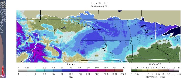

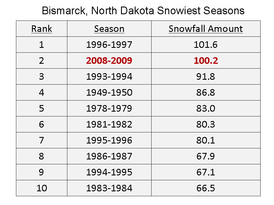
The northern plains has been hit hard this year. Fargo set a record for snowfall and precipitation for March, Bismarck also in North Dakota had record snowfall in December and the second snowiest March, the first year with with two monthly totals in the top ten enlarged here.
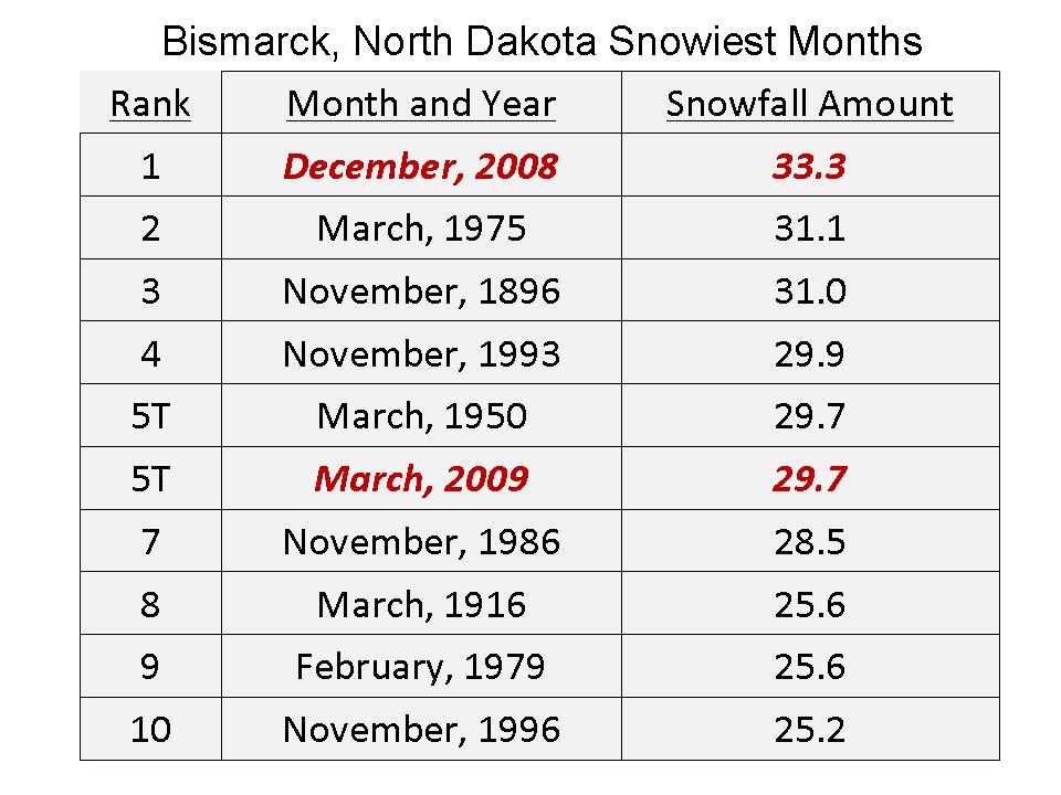

Bismarck is on the northern edge of this storm. If they get more than 1.4 inches of snow from this (or some later) storm, they will set an all-time snow record. See the enlarged listing shown below here as of April 1 after the big blizzard. See all the watches and warnings here.

The National Weather Service said International Falls, with the reputation as the nation’s icebox, recorded 124.2 inches of snow this winter. That tops the old record of 116 inches set in 1995-1996. The nearly 9-inch dump from this week’s snowstorm pushed International Falls over the edge. The Minnesota-Ontario border area has been pummeled with snowstorms this winter.
And from KOMO News Weary Spokane residents who are sick of snow can at least now be consoled by the fact that they were a part of history.
A snow storm on Sunday has made this the snowiest winter on record in Spokane. The National Weather Service said 93.6 inches of snow has been recorded at Spokane International Airport this winter, breaking the record set in 1949-50 by a tenth of an inch. It took snowfall of 3.9 inches of Sunday, a record for the date, to break the all-time record. This is the second-consecutive heavy winter in Spokane. Last year, more than 92 inches of snow fell on the Lilac City, third most since records started in 1893.
Spokane’s Top 5 Snow Years:
RANK WINTER SNOW TOTAL
1 2008-2009 93.6
2 1949-1950 93.5
3 2007-2008 92.6
4 1974-1975 89.0
5 1992-1993 87.3
Spokane is also mired in unseasonable cold. Normal high temperatures at the of March are in the low 50s, but this month has seen highs in the 30s and 40s.
See here how an amazing 358 lowest temperature records and 409 snowfall records were broken for the week ending Apr 2, 2009.
Anthony,
Remember that global warming means more snow, and less snow, and warming, and cooling, and more earthquakes.
Global warming means whatever the current weather is – because the current weather is (of course) due to global warming. Scientists who believe in catastrophic global warming agree that there is a consensus amongst like-minded individuals.
I am sure Obama, Gore and Brown will claim that it would be colder if it wasn’t for global warming of the AGW kind.
However, the “new world order” took another step forward recently at the G20 talks. This whole AGW politically motivated hysteria reminds me of the film “Soylent Green”.
This is a great site, keep it up Anthony, Steven et al.
Steven: Global warming means more snow at northern latitudes and less snow/more rain around the tropics. Please stop bringing forward half-truths like these ones.
See, this is why the watchword is ‘climate change’ not ‘global warming’. Climate change is apparently the only kind of change Obama doesn’t have hope for. Any sort of change is the fault of CO2 pollution and must be fixed with lots of taxes and regulations, while the politically correct climate is one that doesn’t change, like that which exists inside the reality distortion field of Washington DC.
Flanagan (22:54:14) :
Steven: Global warming means more snow at northern latitudes and less snow/more rain around the tropics. Please stop bringing forward half-truths like these ones.
Flanagan – Which part of the following (generally published AGW Proponent) ideas are consistent with more Northern Latitude Snow.
[1] CO2 is a Greenhouse Gas and contributes to warming the Earth.
[2] Increasing Man Made CO2 Emissions will warm the Earth.
[3] The Warming of the Earth will be most pronounced at the Poles.
I don’t see how you can consistently claim that there will be both “More Northern Latitude Snow” and that the above listed ideas make sense.
I’m just going for “consistency” – I’m not saying that you personally have claimed any of the above list of ideas – but would you agree that the 3 ideas listed above are general tenents of the AGW Case and are difficult to reconcile with the idea of more Northern Latitude Snow.
I.e. How can the North Pole be warming – and yet produce increased snow nearby – shouldn’t the snow be retreating to the north?
Does it also mean cooling tropics?
Flanagan (22:54:14) writes in part: “Steven: Global warming means more snow at northern…”
Then it is not global warming, is it. Try climate change, and then perhaps: “Weather’s been a bit capricious this past century or so, huh?” as you ease out the door…
Flanagan, global warming means more taxes!
Climate change means more taxes! Global warming as metamorphosed into climate change, or is that climate extremism?
Flanagan (22:54:14) :
“Steven: Global warming means more snow at northern latitudes and less snow/more rain around the tropics. Please stop bringing forward half-truths like these ones.””
!!!!
Talk about spin. If there is more snow in the northern latitudes and more clouds in the tropics, that is the recipe for the onset of ice ages, in some models. Certainly more rain means more clouds higher albedo cooler earth.
Timing is everything…Spokane was 4 degrees above normal today and forecast to be warmer tomorrow and Tuesday. But April did start out averaging 15 degrees below normal and March clocked in at 7 degrees below normal, so definitely a cool start to spring.
Seattle was also chilly in March, with temps running 5 degrees below normal.
Is anyone else a fan of the new charts the NWS is using that graphically show daily high/low temperatures as well as records? Here’s the Spokane chart for March:
http://www.wrh.noaa.gov/images/otx/cliplot/KGEG200903plot-2.png
Didnt I read somewhere that maximum snowfall seems to occur at 0 to -2 deg C, so it follows that max snowfalls will fall in areas that fall in these temperature ranges, when moisture is present to be converted to snow. If its a lot colder you get desert like conditions ie antartica, if its a lot warmer rain falls.
Thanks for setting me straight. And I actually believed that nonsense about it being cold up in those snowy places, and that global warming meant global warming!
/sarc
Anthony: I apologize for the tone of my previous post; it is just that I get tired of the predictable response certain posters always pop out with every time evidence is shown which threatens their worldview. So I will respond to the point.
Flanagan, the post was about record snow and many record cold temperatures (as well as a few record warm temperatures). How could that be a half-truth when it actually happened? Note that no mention was made of global warming. So, you accused someone of lying with half-truths about something he didn’t mention.
Graeme Rodaughan
Hotter polar regions means more melting AND more evaporation from the seas (even in the winter). So northern regions below the cloud level should undergo more precipitations (as opposed to very high mountains).
The situation is supposed to be different at the tropics and, for what I remember, some intertropical regions are supposed to become drier. Because of the wind patterns. This is all detailled in the IPCC assesment reports – which you should really read one day.
About the clouds: they play a double role. They can reflect part of the sun and altogether absorb IR coming from the surface. It all depends on their composition and/or color.
Flanagan
You mention that global warming means more snow at northern latitudes. What is expected in the south? I found the following study mentioned on Dr. Pielke’s site re: snow cover trends in South America. The paper claims to have developed the first regional snowpack series (1951–2005) from Chilean and Argentinean snow course records.
http://climatesci.org/2007/06/14/snow-cover-trends-in-south-america/
In part it states:
‘Annual and warm-season river discharges on both sides of the cordillera are significantly correlated with the regional snowpack record and show positive linear trends over the 1951–2004 common period, probably related to a greater frequency of above-average snowpacks during recent decades.’
Dr Pielke comments on the whole study:
‘The climate metric of snowfall in South America is clearly not directly related to the global average surface temperature trends. Climate Science has repeatedly shown that the global average temperature trend is an inadequate climate metric with respect to how the climate system actually impacts society and the environment.’
Cheers, ian
Flanagan:
Less snow around the tropics? Since the amount of snow in the tropics is effectively zero, does that mean the models are predicting a negative amount of snow?
“less snow/more rain around the tropics”
Pardon?
Apart from high mountain peaks, I don’t think there’s much chance of snow in the tropics so does this bit of gobbledigook mean a rise in the snowline?
Whilst downunder: “Almost all of TAS(mania) had its coldest day since November or December of last year, with Mount Hartz chilling so much that it had its coldest April day in 13 years of records. It only warmed to one degree today, allowing up to 10cm of snow to fall.
“Victoria too felt the bitter chill, with overnight temperatures dipping to the single digits, with areas of frost about the Wimmera. Snow has also been falling over the alpine peaks, including Mt Baw Baw and Mt Buller.”
Weatherzone
And last week I was cursing the heat here in Victoria.
p.s. When they write “alpine” I think they must mean “New Alpine” … as in New York. Used to be just “the high country” or “the mountains” but someone seems to have cringed…
The alarmists could look at those records and insist that the warming is causing more precipitation – just like the models predicted.
The trouble is the models also predict that the great plains is going to be an a perpetual drought!
Hi,
about dr Pielke’s study. As has been reported in replys to this paper, this part of south america is outside the tropical region and therefore should have increased snowfalls. For example, more snow is observed there when en El nino event is taking place although an el nino is “globally warm”.
For people with a problem in geography: the intertropical region is defined as the region between approx 23.4 degrees S and N. Tropical climates include not-so-“tropical” temperatures: alpine tundra and snow-capped peaks (Mauna Kea, Mt. Kilimanjaro) and the Andes as far south as the northernmost parts of Chile and Argentina.
I believe what they are saying is that when it becomes very very cold, then the air will not contain enough moisture to get a good snow storm going. Once it begins to “warm” up towards the freezing mark, then you have idea conditions for heavy snow.
Flanagan: “Global warming means more snow at northern latitudes”
Now you’ve got me puzzled. I live in the normally mild S-W of England. We’ve just suffered the coldest, snowiest winter for a long time. I thought it was due to cold air coming over from Siberia, but it seems the cold and snow are due to global warming. Our government is closing down coal-fired power stations to stop this global warming which seems to be bringing us cold and snow. It is building wind turbines which don’t work in cold weather when invariably the wind doesn’t blow over here. I burnt about twice as much wood as normal this winter to keep warm because of all this global warming. Does this global warming mean we are about to enter another Little Ice Age when the rivers over here froze and crops failed? Please tell us what we are to do about it.
Meanwhile very long lived ice sheets keep falling off the Antarctic – http://www.theage.com.au/environment/antarctic-ice-shelf-near-final-collapse-20090406-9tvx.html
as a direct result of warming.
Or a direct result of extra large ice sheets.
REVEALED!!!!!
Flanagan is a 14 year old blogger from the Central African Republic.