Paul Dorian
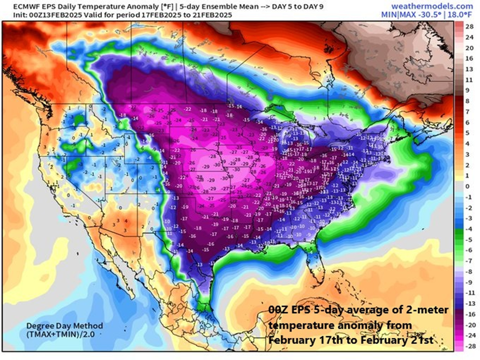
A very cold air mass will flood the northeastern states at the end of the upcoming weekend and next week looks very cold on average across the eastern 2/3rds of the nation. Map courtesy ECMWF, weathermodels.com (Dr. Ryan Maue, X)
Overview
A major storm system will pound the western states during the next couple of days and it will then trek across the nation and wreak havoc in the eastern states this weekend. In California, the rainfall in coming days will be heavy all along low-lying coastal sections from Oregon to the Mexican border, and snowfall will be measured by the foot in the Sierra Nevada Mountains. By the early part of the upcoming weekend, this same storm system will bring flooding rainfall to the Ohio and Tennessee Valleys and then significant snow is likely on Sunday across interior New York State and New England.
In the Mid-Atlantic region, there will be plenty of rainfall this weekend; however, it is likely to be preceded on the front-end by snow and accumulations are possible; especially, to the north of the PA/MD border. Cold air will pour into the eastern states following this weekend storm system and next week is indeed looking very cold across the eastern two-thirds of the nation. Low pressure is likely to gather strength in the southern states by the middle of next week aided by an influx of Gulf moisture and it could become a significant east coast storm threat by later Wednesday or Thursday.
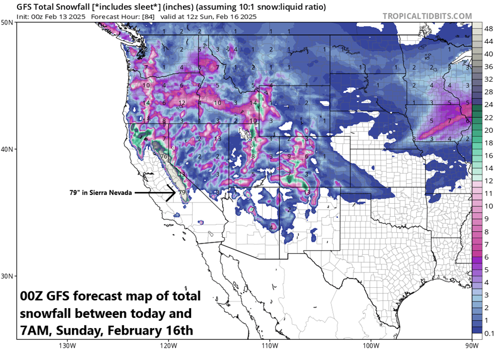
A major storm will impact the western US during the next couple of days with significant rainfall in low-lying coastal sections and substantial snowfall in higher elevation locations. In fact, the snow will be measured by the foot in coming days across the Sierra Nevada Mountains of eastern California and substantial snow will fall in many of the Rocky Mountain States. Map courtesy NOAA, tropicaltidbits.com
Major storm crosses the country next few days
A strong storm system will pound California during the next couple of days with significant rainfall along low-lying coastal sections from Crescent City in the north to San Diego in the south. Substantial snow will fall across the higher elevations of the Sierra Nevada Mountains during this event with several feet in some spots by the latter part of the weekend. This same storm system will then cross the nation and reach the eastern states this weekend bringing flooding rainfall on Saturday to some areas such as the Ohio and Tennessee Valleys and significant accumulating snow to others on Sunday including interior New York State and New England.

The weekend will feature plenty of rainfall in the DC-to-Philly-to-NYC corridor; however, there can also be a quick thumping of snow on the front-end with accumulations on the table; especially, to the north of the PA/MD border. Any snow or sleet that does fall at the onset of the weekend event will change to rain by Saturday night and continue Sunday and some of the rain may be heavy at times. Map courtesy NOAA, tropicaltidbits.com
In the Mid-Atlantic region, the weekend weather event will range from cold and possible accumulating snow on the front-end to mild with plenty of rainfall in the middle and back-end. All of this will be followed by an influx of very cold air on Sunday night and Monday and the first half of next week will be very cold across much of the nation including the Mid-Atlantic region. On Saturday, precipitation may begin as a quick thumping of snow; especially, to the north of PA/MD border. Accumulations of a couple to a few inches are possible across eastern PA, central and northern New Jersey, and in the New York City metro area likely from the late morning to early afternoon hours. Even the DC metro region can experience some snow and/or sleet at the onset of the weekend event around mid-morning on Saturday and a coating or so is on the table. Later in the day, the precipitation will mix with and then changeover to rain and the rain will continue Saturday night and Sunday morning. Some of the rain that falls on Saturday night and Sunday morning can be heavy at times and a rumble of thunder cannot be ruled out. By later Sunday, strong low pressure to the north will drag a cold front through the region and temperatures are likely to plunge late Sunday/Sunday night from the mild levels achieved earlier in the day.
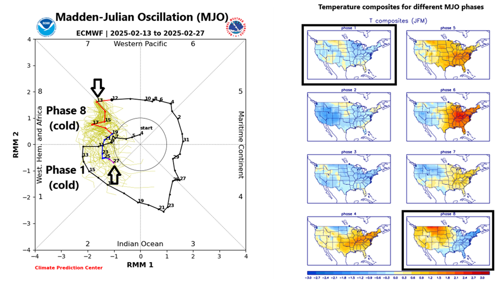
The Madden-Julian Oscillation or MJO is predicted to push through phase 8 and into phase 1 during the next couple of weeks (indicated by arrows, left plot) and these particular phases are typically correlated with colder-than-normal conditions across the central and eastern states (boxed regions in temperature composite maps, right). The colder-than-normal weather pattern that begins in earnest next week could last all the way into the month of March. Plot courtesy ECMWF, NOAA
Very cold next week…possible east coast storm threat mid-to-late week
The first half of next week looks to be very cold across much of the central and eastern US with particularly cold air centered over the central states. This outlook for colder-than-normal weather next week in the eastern half of the nation is supported by the movement of a tropical disturbance that is tracked by meteorologists using a teleconnection index known as the Madden-Julian Oscillation or MJO. Depending on its location (or “phase”) for the given time of year, it can provide clues as to the temperature patterns across the nation.
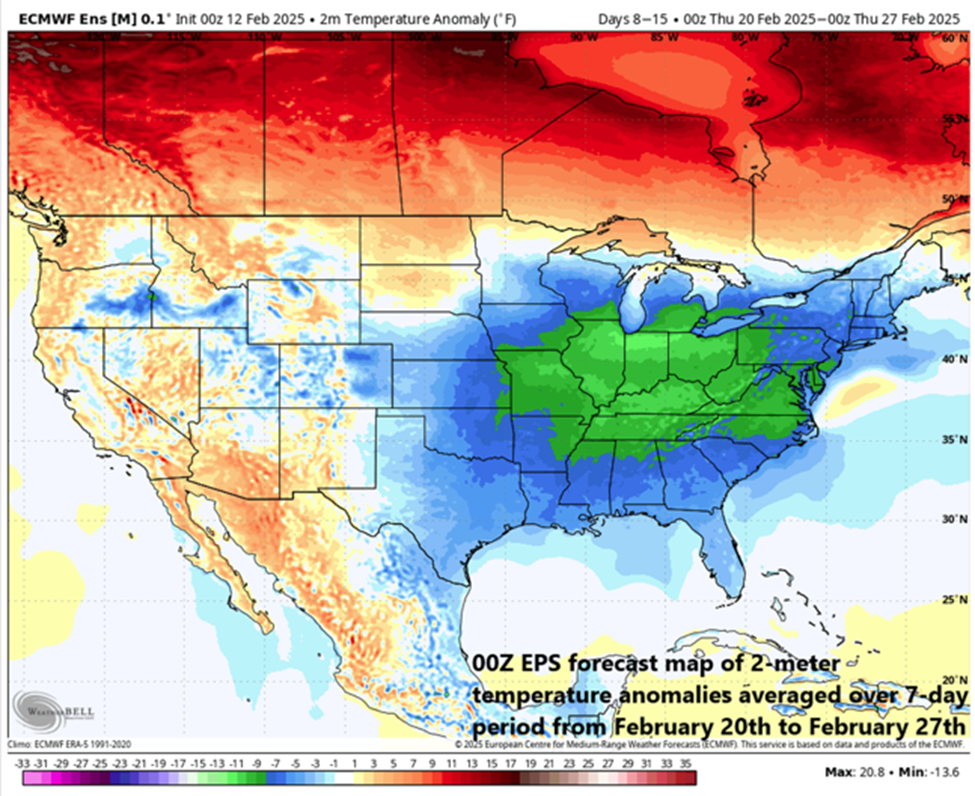
Next week is destined to be very cold across much of the nation and this colder-than-normal pattern could take us all the way into the month of March. The 2-meter temperature anomaly forecast map shown here for the 7-day period of February 20 – February 27 depicts much below-normal temperatures across the eastern half of the nation with a focus on the Midwest/Ohio Valley. Map courtesy ECMWF, Weather Bell Analytics
At this stage of the winter season, when the MJO moves into phases 8 and 1, temperatures are typically below-normal across the central and eastern states. Indeed, it appears the MJO will push into phase 8 during the next day or so and then into phase 1 around February 22nd or so…this colder-than-normal pattern may even last right into the month of March.
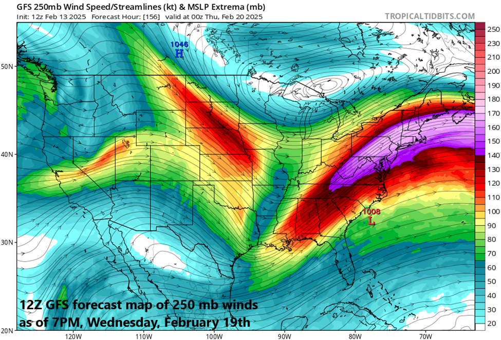
The overall active weather pattern across the nation in recent weeks will continue through at least much of next week and one of the supporting factors has been powerful “jet streak” activity in the upper part of the atmosphere. This forecast map of 250 millibar winds for next Wednesday evening, February 19th, suggests strong surface low pressure may develop somewhere near the Mid-Atlantic coastline. Map courtesy NOAA, tropicaltidbits.com
By later Tuesday of next week, moisture will push northward into the Mississippi Valley resulting in snow to the north and rain down south. Low pressure over the northern Gulf region will then make a move to the northeast and head towards the Atlantic seaboard and it will encounter plenty of cold air across the Mid-Atlantic region. Exactly how far this system moves up along the east coast remains to be seen, but the threat is there for a significant impact in the Mid-Atlantic region by the middle or latter parts of next week…stay tuned.
Meteorologist Paul Dorian
Arcfield
arcfieldweather.com
Follow us on Facebook, Twitter, YouTube
Video discussion (YouTube)
The “next couple of days” in California are already closing out and will be gone by Friday morning. Lesson I will probably never need: Never use relative dates or days; even “Wednesday and Thursday” or “end of the week” would have been more helpful.
Snow in the winter?
It always snows somewhere.
Unprecedented
Worse than expected
Will cool boiling oceans
Proof of manmade global warming.
It’s bad news weather, so must be “climate change”
If it was good news weather, it would just be weather.
If the prediction is wrong, meteorologists will claim a dog ate their papers! Or there was a drifting weather satellite.
To simply the task of publishing six articles a day, WUWT will publish a daily weather report for the US.
Almost good.
You missed the point of explaining MJO.
Were WUWT editors really unable to find another decent article on climate or energy?
So they filled the available space with a weather prediction that will be out of date in a few days?
I don’t get it.
Will there be another article analyzing how accurate this weather report was? Scary weather predictions usually exaggerate the coming bad news to get attention.
The next time there is the need for another article on climate or energy, I suggest a glance at my blog where I recommend at least 12, and usually more, such articles every day of the year. No weather predictions or climate predictions, however. Weather predictions are available, and frequently updated, at many dozens of sites all over the internet.
Honest Climate Science and Energy
When any variation from the mean, whether it warmer or cooler, is the result of “climate change,” then any weather forecast must indicate climate change.
Richard Greene: To follow your argument to it’s logical conclusion, all weather is climate change.
Weather refers to the short-term atmospheric conditions like temperature, rain, and wind at a specific location, while climate is the long-term average of weather conditions over a significant period, typically 30 years or more. Climate can be local, regional, national, for a continent or a hemisphere, or global.
30s we were burning and 70s freezing…climate extinction indeed. Meanwhile more and more land is covered in concrete and asphalt.
There is no global climate beyond the simple averaging of local and regional weather.
It depends on definition an purpose of defining global climate. We live in relatively cold Ice Age climate, yet one could say that “frozen ball” climate was much colder than today’s or that overall Earth’s climate in dinosaurs’ time was much warmer than now.
Purpose? Just quoting the IPCC definition.
Yes.. We are in an interglacial period.
The earth’s climate is generally that of the frozen ball.
And yet, you’re still here
Ad making more sense than you.
And still making more sense than you.
Not at all. If you don’t want to read an article, don’t. If, having read it by mistake, you find you wasted your time, don’t waste more time bellyaching about all your wasted time; it comes off as hypocritical and petulant.
“(Ad) And still making more sense than you.”
It doesn’t matter how many times you say it, it will not come true unless you have the right slippers.
And your little dog, too.
I don’t get it.
As usual 😀
“I don’t get it.”
Tatoo that on your forehead. It will make life much easier for those that have to interact with you.
I for one certainly hope that the prediction will be out of date in a few days. Right now, in the 10 day forecast, my little bit of heaven is looking at over night lows of 10 -12 degrees (f) come tues, wed, Thursday,, and that creates all sorts of trouble for both me and the critters I support. Would much rather not see it come to pass.
“I don’t get it.”
And probably never will…..
The Trump effect. Three weeks in and the USA is set for Global Freezing™ rather than Globull Warming™.
USCRN just came out as the COLDEST January in the whole record.
It’s going to be an unusual Arctic hit for the US.


Strong high over Michigan and frost in the Great Lakes region.


What are they using to record temp 5cm above ground??
The soles of their feet when wearing clogs, obviously.
Sheesh, some people just don’t keep up with climate measuring methodologies.
In the above mapping (the ‘feels like dipiction), the -3 that is right next to New York should be changed to -16 and labeled as ‘Hillary’.
The high that stretches from Arctic Canada to the Gulf of Mexico shows the flow of Arctic air.

The Gulf of Mexico no longer exists. !
It is now called the GULF OF AMERICA. 🙂
That’s Gulf of America
I would have preferred ‘Gulf of the Americas.’
Slightly OT, but I’m going to throw this out there. I’m not a lawyer or government/regulatory expert and I know Biden closed off a bunch of territory for petroleum exploration and I don’t know how easy or difficult they might be to overturn or reverse.
I wonder if a lot of the closures are for the “Gulf of Mexico,” so Trump renamed to the “Gulf of America” to open leases in the GoA, thereby bypassing Biden’s closures. Would be brilliant and would be a huge “look squirrel” distraction for the left.
That’s pretty funny. But courts deal with women changing their name when they marry, and immigrants whose birth/legal names are in different alphabets, so I don’t an EO would give them pause.
ETA: I bet all leases are by latitude/longitude or some other more reliable definition anyway, and the same applies to lease areas in Biden’s EO.
Yeah but it’s the exploding heads effect that Trump really intends.
(and clearly, it’s working)
Yeah, you’re probably right, makes sense. But I still like the added entertainment of lefty’s heads exploding as point out by Mr. Mr., below (above?).
The President of Mexico is suing Google because Google Maps is now showing the gulf as Gulf of America for US viewers. It’s still Gulf of Mexico for the rest of the world.
I’m trying to figure out what grounds she is using for this suit.
Grounds?? She don’t need no Stinkin’ grounds!! She’s a card-carrying, dues-paying lefty. That’s all the grounds she needs. Lawfare and violence are the only methods they know.
Next week there are two days with forecast highs 40 F below average here .
Where’s my global warming ??
😉
I’d like some global warming if you have any to spare.
Where’s “here”?
Good question, one I frequently ask.
East central Kansas . Forecast from Accuweather .
3F highs , one low -12 F . Average high 47 .
It’s hiding in the oceans again. Probably also looking for any gold bars that might be scattered about.
Run away! CLIMATAE CHANGE! Time to panic!
/s
Just waiting for the next set of headlines.
I guess the rat didn’t see its shadow.
Looks like snow in the mountains of New Mexico…good news as I’ll be there skiing.
Very dangerous (tornadoes) forecast for February 16. Strong frontal thunderstorms.

This will be the second stage of a couple of below-seasonal systems affecting both the US and Canada. Eastern Canada has already experienced heavy snow from the first phase of them, while much of the western part has had daytime highs well-below monthly averages. This is the second half of winter, so with global warming supposedly taking hold of the planet, how can this being happening?
?
Strong thunderstorms from Louisiana through Alabama to Tennessee.
Snowfall and frost in the Midwest. Very large temperature difference means high humidity on the eastern side of the front.