New study makes grim reveal about New York City’s skyscrapers: ‘It is a deep concern’
Ben Raker Fri, June 30, 2023 at 11:00 AM PDT
The Big Apple has grown too big for the land it rests on, according to a study released in May showing New York City is sinking under its own weight as the waters around it rise.
What’s happening?
The study, published in Earth’s Future, finds that the Big Apple, home to more than eight million people, is sinking at a rate of about 0.4-0.8 inches [10-20 mm] per year.
YIKES!
Now, I’m pretty conversant with the sea-level data, and that made no sense. I thought, maybe they didn’t read the underlying study. So I read it. It says:
We present satellite data that show that the city is sinking 1–2 mm/yr with some areas subsiding much faster.
Hmm … the alarmist article says 10-20 mm per year, based on a study that says 1-2 mm per year …
Moving on, the article also says:
The average sea level near the southern tip of Manhattan has risen about 9 inches since 1950, as reported by SeaLevelRise.org.
Following the trail of that link, I find SeaLevelRise saying:
Sea level rise is speeding up
The sea level around Battery, New York, has risen by nearly 9 inches since 1950. Its speed of rise has accelerated over the last ten years and it’s now rising by 1 inch every 7-8 years.
They link that to the NOAA sea level data for The Battery, New York. So, it’s off to the NOAA data. There, I find the following.
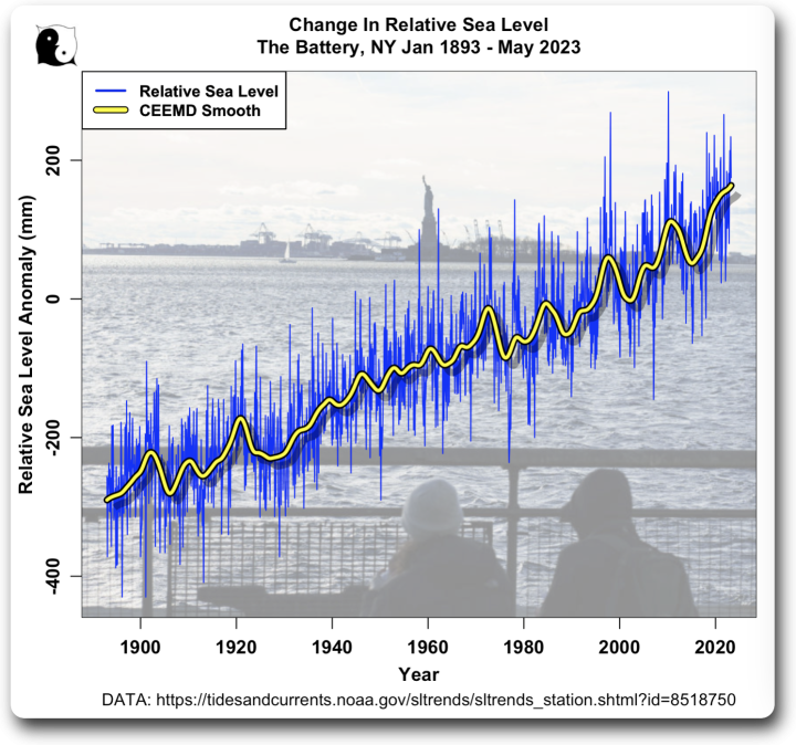
Figure 1. NOAA sea level rise data for The Battery, New York. SOURCE
That says that there is a relative sea level rise of 2.9 mm/year. It’s been 73 years since 1950. That’s 211.7 mm, or 8.3 inches … I suppose on some planet that’s “almost nine inches” as they say. Close enough for government work, I guess.
But is it true that the “speed of rise has accelerated over the last ten years” as they say? To determine the answer, I got the sea level data shown in Figure 1. I discarded the pre-1893 data due to the long gap in the data prior to that. Here’s the result.
Figure 2. NOAA sea level rise data, plus CEEMD smooth of the data
So is it true that the “speed of rise has accelerated over the last ten years”? Yep. And it’s a perfect example of what I call “lying with the truth”. As you can see in the data above, the sea level goes up and down quite regularly. The current rise started in 2015. It is nearly identical to the 2003-2011 rise, which looked much like the previous rise, which was very similar to the rise before that …
Here’s a longer look at sea-level changes at The Battery. Figure 3 shows the thirty-year trailing acceleration and deceleration of the sea level there.
Figure 3. 30-year trailing acceleration and deceleration of the sea level.
All I can say is, it’s a good thing we didn’t have these hysterical alarmists back in the 1940s when the acceleration was at its modern peak. They’d have totally lost the plot, just like today only worse … the rude truth is, the rate of sea level rise speeds up and slows down, and as far as we can tell, that’s just its nature.
Conclusions? Yes, New York is sinking. It has been since the last glaciation. And yes, the buildings are increasing the rate of sinking … although from the sea level data, that’s not having much of an effect.
And yes, the rate of sea level rise goes up and down. Get used to it.
Here, it’s a lovely night, almost full moon. I’m going for a walk outside to clear my mind of the endless modern fear of the future. Why do people insist on believing there is some terrible event just over the horizon?
I reckon I’ll go pose that question to the redwood trees … they’ve always given me good advice in the past.
My best moon-lit wishes to all,
w.
My Customary Plea: To avoid misunderstandings, please quote the exact words you are discussing. Thanks.
4.964votes
Article Rating
97 Comments
Inline Feedbacks
View all comments
Stephen Wilde
July 1, 2023 10:15 am
Good work as usual.
The downside of modern communications is that vast numbers of people have their livelihoods or sense of self importance tied up with spouting bad news.
Bad news sells but good news does not.
The last period of time when there was optimism was during the 50s and 60s when there was a sense of wonder about prospects for the future.
All gone now and without good reason.
Fran
July 1, 2023 10:15 am
Hmm … the alarmist article says 10-20 mm per year, based on a study that says 1-2 mm per year …
The poor person probably had a disability. I had a student once who could inspect a column of numbers and fail to see the one that was an order of magnitude greater than the rest. She was totally number blind.
A fun piece of economic advice I got from John Kenneth Galbraith in college. During WW2 he headed the office of price administration. He taught himself to scan a column of numbers and estimate the sum to within 10% (the trick is rounding because the ignored bits tend to zero out). That was good enough for government work. And then he added, and if it isn’t good enough then you are asking the wrong question.
I’m becoming a p.i.t.a to the grandkids by exhorting them to master the 12-times tables for addition / subtraction / multiplication & division in their heads instead of pulling out their Ipods every time they want to work out if they have enough cash to buy icecreams.
John von Neumann could divide 6 figures by 6 in his head at the age of 6. We can thank him for major contributions to computer technology, atomic physics and our guidance systems.
Yup. Not only did, graduated summa with an undergraduate thesis already accepted ,as a PhD thesis. Long story, I am a HLS/HBS joint program rather than a Harvard econ PhD. Paid more.
antigtiff
July 1, 2023 10:16 am
Oh the humanity! Oceans are not just rising…but are becoming boiling acid pools!….and those ships are carbon polluters!
Me too. My latest fave is Sequacity.
Ductility; pliableness.
Quality or state of being sequacious; sequaciousness.
As in people blindly believing stuff they see/read/hear, or perhaps even obedience to over reaching officials.
Willis E. is NOT that..as we know, he checks most things out for himself.
JasonL
July 1, 2023 10:27 am
9 inches in 73 years (since 1950) is about 1 inch every 8 years. And it’s supposed to be accelerating to…1 inch every 7 or 8 years? Head for the lifeboats!
Thanks, guys! When you post, I’ll start to worry. I’m at 5700 ft.
Seriously, I pay mandated flood insurance to the county. Our house is on a mountain ridge. Reno lies south of us15 miles at an elevation of 4500 ft. It’ll be pretty wet there by the time we flood!
314 ft here according to the Ordnance Survey map. Some time back the meejah claimed that sea-lavel would rise by 250 ft due to “global warming” (whatever that is). Looks like I’m sitting pretty; not sure about the centre of town (100 ft lower), though…
The town centre better start evacuation now! Civic leaders will follow the science and adhere to the green talking heads and take urgently needed action re: the climate emergency – at current rates the town centre will be completely flooded in just 30,000 years! (Rounding up to 1ft/century to avoid doing the math for a stupid issue anyway)
So about the height of 1 concrete block covers 50 years – so even at the glacial speed of government action, there is plenty of time to build sea walls or retaining walls, etc. in the affected areas – and the vast majority of areas completely unaffected by this stupidity might even chip in to to get the enviros to shut up.
Giving_Cat
July 1, 2023 10:32 am
Willis you say: “And yes, the buildings are increasing the rate of sinking …”
Truth is that the buildings on the island of Manhattan weigh less than the rock excavated for their construction.
Quite frankly, the only thing about Manhattan going under that would bother me is that some of the people that live there would move out here where I live. We already have an influx of Californians. Met two families that moved here from there in the last month.
I guess it’s a matter of how one looks at it. For this Hoosier I’m glad of that. Besides I gave up on California. It’s spiral into insanity has only been accelerating.
Correct. The volume of excavation – mostly rock – for the new One World Trade Center building is reported publicly to have been 1.2 million cy, each cy with a mass of around 1.5 tons for a total mass of 2.25 million tons. I have been unable to find a figure for the mass of the new One World Trade Center building structure, but public data for the old twin towers was 450 thousand tons per tower, or 900 thousand tons. The floor area of the old twin towers was 13.4 million sf, while the floor area of the new One World Trade Center building is only 3.5 million sf. So if one assumes the mass of the new One World Trade Center is proportional to the floor area, then the mass of the new single building would be somewhere on the order of a quarter million tons, vs. the two and a quarter million tons mass of the excavated materials.
This is just one building, but it is typical for the high rise buildings that dominate Manhattan to be far lighter than the material excavated for the foundations, sub basements, basement, parking, etc.
If NYC is subsiding, it is not due to the weight of the buildings built.
Yet parts of it were projected to already be under water because of “Climate Change” caused by Man.
(PS The old buildings are concrete. The new buildings are built of lighter stuff. Yet none are flooded.)
In 1988 James Hansen predicted that in 40 years NYC’s “West Side Highway will be under water.” (Salon misreported it as 20 yrs.)
Years later Hansen added an “assuming CO2 doubled” caveat, claiming to recall that that’s what he’d actually said to journalist Bob Reiss back in 1988. But I don’t believe him. There doesn’t seem to be any contemporaneous evidence that Hansen mentioned such a caveat, and it doesn’t pass the smell test.
It seems implausible that he could remember such details about a conversation which happened years earlier. Additionally, back in 1988 the atmospheric CO2 concentration was less than 352 ppmv, and it was rising by only 1.63 ppmv or +0.476% per year. For the CO2 level to reach 570 ppmv by 2028 would have required a wildly accelerated average annual CO2 increase of ((570-352)/40) = 5.45 ppmv or +1.21% per year.
Hansen assumes many silly things, but that doesn’t seem like something which even he would assume.
The rate of CO2 level rise did accelerate after 1988, but only slightly. Over the last decade the atmospheric CO2 concentration has increased at an average rate of 2.45 ppmv or +0.603% per year.
Duane, the excavated rock was dumped at the southern part of Manhattan in the Hudson. After many years someone realised that if the area was covered in concrete then new buildings could be erected and that is Battery Park City. The apartment blocks are only about three stories because that is all the bedrock can support.
The bedrock in Manhattan can support any height of building. The bedrock there consists of schist and marble, extremely strong rocks (as measured by compressive strength). Florida’s bedrock – where I live – can easily support skyscrapers of any height, and that rock is weaker and less competent limestone. The taller the building the deeper the foundation piles are sunk into the bedrock. Piles used in foundations rely mostly upon their frictional support rather than end bearing support, whether in bedrock or soils.
Relatively tall buildings do not necessarily even need foundations in bedrock, depending upon the characteristics of the underlying soil, depth to bedrock, groundwater table, and what the building developer is willing to spend on deep piles.
Well there is the pre-existing solution to the non-problem of sea level rise – just keep building up Manhattan, with the excavated rock dumped and worked by the seashore into higher and higher levels, all paid for by the construction itself.
The Battery, at the southern tip of Manhattan Island, shows an atypically high sea-level trend due to local subsidence, but I don’t know whether that’s true for the whole island. The Battery is very near Battery Park, which is land reclaimed from the brackish Hudson River. It is built on fill dirt that’s still compacting (though not as much as Galveston).
But the land is also thought to be sinking due to PGR. When the great Laurentide ice sheet had receded to New England, the future site of NYC was in a an area which bulged upward due to compression of the land to the north. That bulge (including NYC) is now sinking. (Prof. Richard Peltier has estimated the rate of subsidence at 1.67 mm/year, but that’s model-based, and not precise.)
The Empire State Building is claimed to have a weight of 365,000 tons, exclusive of the furnishings and the 21,000 people (~2,100 tons) that reside in it. Surely the wood, plastic, and metal furnishings weigh at least as much as the people, for a total weight of about 370,000 tons.
I came across one estimate for the excavation removing 125,000 tons. So, the answer isn’t a slam dunk and depends on whether the building has a large sub-surface cavity, or relies on pilings of unknown weight. 370/125 ~ 3.0
After giving some more thought to this, I’m of the opinion that you have presented a straw-man argument. What is at issue is whether the high-rises that characterize Manhattan’s skyline are, or are capable of, inducing isostatic adjustment that presents as subsidence.
Even if your assertion is true, which I doubt, we have to look at the big picture. That is, all the building materials for the high-rises have been brought in from other states, and although rock has been excavated for basements and foundations, the material removed has been dumped along the margins of Manhattan, such as at the Battery. Thus, while moved, the excavated material still has a local loading on the crust. Overall, there has been a net gain of loading for Manhattan with construction material and people. So, in theory, it should result in a response. The question is whether the response will be fast enough to actually be measurable in years. Not being a petrophysicist accustomed to quantitatively dealing with the plastic response to surface loading, I’ll pass on making an estimate of the rate of deformation, which almost certainly will occur.
OK, I get it that at least two people dislike what I said. However, is there any substantive response along the lines of my facts or logic being wrong? If not, then why should I or any reader really care what anonymous commenters like? Science isn’t a popularity contest.
Clyde, the only thing I disagree with in this comment (which I up-voted) is characterizing Giving_Cat’s disagreement as a straw-man argument. It might be right, or it might be wrong, but it’s not a strawman.
Thanks, Joe, your contributions are always welcome.
w.
Walter Sobchak
July 1, 2023 11:00 am
Thanks Willis.
I am not worried about Manhattan sinking. Much of it is basement rock, particularly along Broadway downtown (Chambers to Battery), midtown (Herald Sq. to Columbus Circle) and on the Upper West Side (103 to 125). There are swampy areas such as the World Trade center, which was built on land fill into the river, and Turtle Bay where the UN sits (aptly).
But, it makes no difference. New York real estate is so valuable that almost any civil works like sea walls are easily worthwhile.
My thoughts exactly when looking at the picture of what’s built there. I was reminded of the Netherlands and their protection of infrastructure built below sea level.
Mass vs weight: Just curious, what does a skyscraper weigh? Doesn’t a portion of it “float” like a boat in water? A collapsed building leaves a mound of rubble, not a mountain.
If the Empire State Building were replaced with the local Manhattan Schist on the same footprint it would only be 50 feet high.
Wim Röst
July 1, 2023 11:36 am
Willis: “Why do people insist on believing there is some terrible event just over the horizon?”
WR:
Actually, all who produce the fear get paid for it
All have been brought into ‘A state of Fear’. Mass psychology learns that when a person becomes ‘in a state of fear’, normal, balanced, and rational thinking stops and people ‘just follow the leader’.
And there is another, not unimportant point. When it seems to be necessary ‘to save the Earth’, everything seems to be permitted.
So the trick was: first bring them ‘into a state of fear’, second: pay all who became feared and who ‘wish to spread “the word”, three: exclude any real discussion, four: make a simple problem as complex as possible and five: tell all who cannot oversee the complex problem created, that ‘We are the One and Only Leader’. The Authority. People will believe everything The Authority says, and as a result, will continue to stay in that ‘state of fear’. All happened.
To get out of that fear every individual needs to (re)start rational thinking. And needs to resist ‘what all say’. Not so many people succeed.
Not just exclude, but ridicule, accuse the perpetrators of all sorts of nasty things, etc.
Rud Istvan
July 1, 2023 11:37 am
“Study published in the journal Earth’s Future”
It exists. Hosted by Wiley, sponsored by AGU. “Trans disciplinary open access journal examining the state of the planet, its inhabitants, sustainability and resilience.”
So I browsed other recent papers summarized below:
Mass extinction relationship to atmospheric CO2–correlated so we are causing the next one now. Sounds a familiar alarm, but simply not true. See essay No Bodies in ebook Blowing Smoke for details.
Anthropogenic intensification of hot+dry summers—meaning intensified crop failures. Except there is ZERO evidence for this as almost all yields are increasing thanks to greening. So more models
Proactive Wind/solar complementarity. Maybe they figured out how to get the wind to blow more at night? Nope, just run a gabillion more miles of transmission to hook intermittent stuff together better. Except that already doesn’t work in Europe given the size of its weather systems.
Agrisolar benefits. Except crop plants don’t grow under solar panels because not enough light. And if you space solar out, then the crops between get trampled when you have to go clean the panels so they can keep producing green electricity.
All just as nutty as the NYC sea level rise paper. Speaks very poorly for the AGU.
There is no end to climate exaggeration. The temp here is forecast to reach 29C today. Media News feed says heat waves, droughts, CC, only-gonna-get-worse doom……yet only 10 days ago, summer solstice, the local media had the following…which never hit big media anywhere of course.
That’s disturbing. A slap in the face to a long tradition of amateur scientists, educated critical thinkers and those who enjoy learning about real science. This is what happens when you begin to dumb down – scientists do mickey-mouse degrees and think they’re suddenly better than Richard Feynman and the rest of us get ordered to stop thinking for ourselves.
On the East Coast of Australia where a life time of observation shows that king tides today are LOWER than they were in the period from 1946 to 1953, makes amateur science at least as capable as the cli-sci of today.
Ian_e
July 1, 2023 12:35 pm
‘Why do people insist on believing there is some terrible event just over the horizon?’
Maybe because there is! {Hint: it is the arrival of complete totalitarianism.}
Aside from the failed projections that parts of NYC should already be underwater, how long before before I need to buy waders to cut my grass?
(I live in central Ohio. It used to be part of an inland sea.)
The NOAA chart for Bamfiled, British Columbia is a good one for asking the question: How exactly is that Ever Accelerating Sea Level Rise manifesting itself In Bamfiled on Vancouver Island Canada?
“The relative sea level trend is 0.0 millimeters/year with a 95% confidenceinterval of +/- 0.74 mm/yr based on monthly mean sea level data from1969 to 2018 which is equivalent to a change of 0.00 feet in 100 years” Sea Level Trends – NOAA Tides & Currents
Dave Burton
July 1, 2023 1:20 pm
Excellent job, Willis.
NY City has two fine, long sea-level measurement records. The one on Manhattan Island at The Battery has the longer measurement records. The one at on Long Island at Kings Point experiences less subsidence.
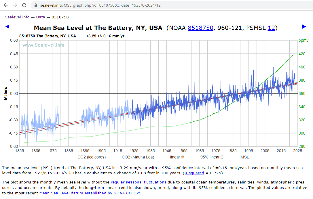
Here’s The Battery: https://sealevel.info/MSL_graph.php?id=8518750
(data from 1856/1 to 2023/5)
Linear & quadratic egression find:
linear trend = 2.911 ±0.085 mm/yr acceleration = 0.01058 ±0.00364 mm/yr²
They both show a slight acceleration, but not enough to be worrisome.
At the Battery, the measurements start in 1856, but there’s a big gap in the 19th century data, and the trend then was noticeably flatter. If we just look at the last 100 years of measurements, it looks like this: https://sealevel.info/MSL_graph.php?id=8518750&c_date=1923/6-2024/12
linear trend = 3.293 ±0.163 mm/yr acceleration = 0.00641 ±0.01258 mm/yr²
On this graph, I’ve contrasted sea-level with atmospheric CO2 level. It’s clear that the CO2 level is not appreciably affecting the sea-level trend:
The first of those three acceleration figures achieves statistical significance, and the second almost does. But none of them are large enough to be practically significant.
We’ll quantify that, but first a brief digression.
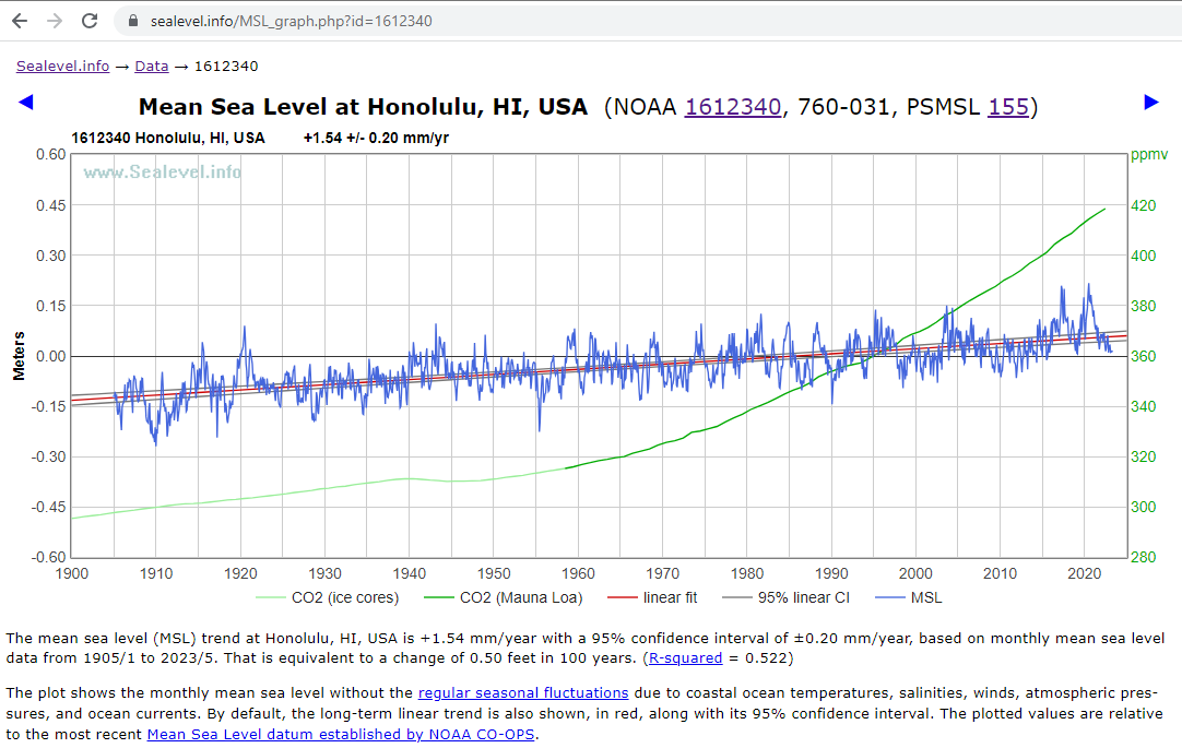
Because of the land subsidence at New York City, the local (“relative”) rate of sea-level rise there is greater than in most other places. Honolulu, where there’s little or no subsidence, has a more typical measurement record: https://sealevel.info/MSL_graph.php?id=1612340
(data from 1905/1 to 2023/5)
linear trend = 1.537 ±0.203 mm/yr acceleration = -0.000147 ±0.013251 mm/yr²
On this graph, I’ve contrasted sea-level with atmospheric CO2 level. It’s clear that the CO2 level is not appreciably affecting the sea-level trend.
As you can see, there’s been no acceleration at all in the sea-level trend at Honolulu. That’s true at many measurement sites, but quite a few others have, like NYC, recorded slight accelerations.
To calculate the effect of “acceleration” use the following quadradic formula:
y = B + M·x + (A/2)·x²
where:
x is elapsed time
y is position or sea-level after time x
B is initial position or sea-level
M is current rate
A is acceleration
So if:
M = 1.5 mm/yr
A = 0.01 mm/yr²
x = 100 yrs
And if the trends were to continue:
y = B + 100·1.5 + (0.01/2)·100²
= B + 150 + 0.005·10000
= B + 150 + 50
= 200 mm = 7.9 inches
6″ of that 8″ is from the linear trend, and 2″ of that 8″ is due to acceleration.
However, there’s a subtle twist. When acceleration is estimated by quadratic regression, we’re fitting a quadratic curve to the measurement record to date. Extending that curve is the projection. But the curve’s slope matches the linear tread at the midpoint, not at the end.
So, to find y (sea-level) 100 years from NOW, we should use x = 100+(L/2), where L is length of the measurement record.
So if we have a 100 year measurement record, to calculate the accumulated effect of the acceleration 100 years from now we should use x=150, not x=100.
Remember our formula:
y = B + M·x + (A/2)·x²
That last term is the effect of acceleration; using x=150 we get:
1.7 mm/yr is what NOAA tells us, but it’s buried in their giant web page. Let’s see if I can dredge it up for you:
Areas experiencing little-to-no change in relative sea level are illustrated in green, including stations consistent with average global sea level rise rate of 1.7-1.8 mm/yr. LINK
Besides that over 60 long term tide gauges listed in the PSMSL and using Excel’s 2nd order Polynomial trend line with the “Display Equation” box selected. It’s easy to find that acceleration centers around 0.01 and zero mm/yr². In other words, nearly nothing.
For New York it’s y = 0.0052 + 2.0266x + 6692.9
where 2x 0.0052 = an acceleration of 0.0104 mm/yr²
For Fremantle it’s Y = 0.0067 x2= 0.0134 mm/yr² also nearly nothing.
Thanks Steve. Your link led me to the actual Fremantle data. Initially I just established the 1.7mm figure by averaging the rise from 1897 to now.
Bill S
July 1, 2023 2:13 pm
By removing the heavy rocks at the bottom of the buildings, and adding weight far above ground level, the center of gravity must therefore be higher than before all of those buildings were built.
The subsidence shows that because of the higher center of gravity, Manhattan Island is slowly tipping over. Perhaps Michael Mann, AOC, or some other climate change luminary will tell us how much longer until the “tipping point” is reached, and all of the buildings on Manhattan slide into the Hudson.
I’m somewhere near the UK tipping point – the south coast is sinking and the north of Scotland is rising – at some point we’ll flip over and Scotland will find itself catapulted into France (much to the annoyance of both the French and Scots).
RMoore
July 1, 2023 2:15 pm
Willis , your statement ‘ a walk outside to clear my mind’ reminded me of the lyrics in this song.
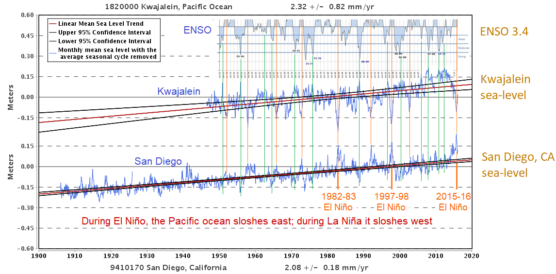
Willis, in your acceleration graph, I note the two most recent peaks coincide around 1998 and 2015 coincide with the two biggest El Nino events of the last 25 years. Basically winds piling up water, and water expanding somewhat due to heating.
Here, NOAA talks about the El Nino effect on sea-level:
And here is an image of sea level from the 1997/1998 event:
“NOAA says: The colors represented in the images show sea level height relative to average. The white and red areas indicate areas of higher than normal sea surface heights. In the white areas, the sea surface is between 14 and 32 centimeters (6 to 13 inches) above normal; in the red areas it is approximately 10 centimeters (4 inches) above normal. The green areas indicate normal conditions, while purple indicates areas that are at least 18 centimeters (7 inches) below normal sea level.”
Even the acceleration is a natural event, with no help from mankind.
It surprises me to see that correlation at NYC. But in the eastern and western tropical Pacific, ENSO has a very strong influence on sea-level.
My understanding of it differs from how that NOAA article describes it. La Niña comes with strong easterly tropical Pacific trade winds, and that wind carries water along with it, so the Pacific Ocean “sloshes west.” As a result, water levels go up in the Western Pacific, and down on the Southern California coast.
(California also usually gets less rain during a La Niña, so during La Niña the Climate Industry predictably pumps out FUD about climate change causing devastating droughts.)
El Niño does the opposite. Easterly tropical Pacific trade winds diminish, so the Pacific sloshes east.
(Shallower water at the Great Barrier Reef increase the frequency of coral bleaching events. So the Climate Industry propaganda mill stops talking about California droughts, and instead churns out stories about record temperatures & coral reef devastation.)
This graph is out of date, but it slows how the tropical Pacific sloshes back and forth with ENSO cycles. It shows an ENSO index at the top, above two sea-level graphs: Kwajalein in the Western Pacific, and San Diego in the Eastern Pacific. Orange vertical lines indicate El Niños, and green vertical lines indicate La Niñas.
Note that the Kwajalein and San Diego sea-level graphs are almost perfect mirror images. San Diego sea-level is very strongly positively correlated with ENSO, and Kwajalein sea-level is very strongly negatively correlated with ENSO.
Willis,
Most of your posts more or less start with mention of you retrieving data from wherever it lives, then proceeding to graph and analyze it. Apparently much of you analysis uses program tools, often written in R.
I want to do a little of that, purely for my own curiosity. In particular to compare recorded temperatures over selected periods of time in different locations. Maybe I will learn something, maybe not, but my first problem is getting started.
For instance, to relate to your current article,
starting with the search term noaa sea level data I found this page https://coast.noaa.gov/slrdata/
which is labeled Sea Level Rise Data Download
selected New York
under the heading Bronx, Kings, Nassau, New York, Queens, Richmond, Rockland Westchester
clicked on Sea Level Rise
and received a zip file containing a folder of 128 files, most in groups of 4 types,
plus 2 meta documents.
Do you know if there is anyplace that explains what these are and how to access whatever they contain? Of course, if temperature data is presented in some significantly different way, I may need to study a different lesson but then you also seem to have considerable experience with temperature data. Any help you can offer will be appreciated.
Couldn’t say what’s what, Andy, but it’s all maps of what might happen if there is a sea level rise. If you use the data viewer you can see the maps, but I have no clue what their format is.
Regards,
w.
Edward Katz
July 1, 2023 5:59 pm
The alarmists don’t base their conclusions on facts or reality; instead, it’s on wishful thinking.
“The Dream” justifies the means.
“Climate Change”/”CAGW” is just a means.
Keith.
July 1, 2023 10:05 pm
“Yes, New York is sinking. It has been since the last glaciation.”
I thought that NY might be rising due to isostatic rebound after the glacier melt, I have seen conflicting articles on this, so all are welcome to correct me.
It’s a complicated issue – all down the North American East Coast you have isostatic rebound and settlement occurring, coupled with a small amount of sea level rise as well as some sinking from groundwater extraction. All of this is going on at different rates in different locations and confuses the issue a bit. I think New York is still subject to a slight isostatic rebound but this is less than the SLR so sinking slightly.
It is generally thought that there is rebound where the land was covered with thick ice, and subsidence in the area of the fore-bulge. However, because the leading edge of the ice sheet was probably much thinner (a few hundred feet thick) than the maximum thickness (a couple miles), the fore-bulge could have been under the ice at the leading edge.
Clyde ==> The “hinge point” for the US Eastern Coast is though to be about Boston. So NYC hinges downward.
The subsidence is a measured quantity.
Geoff Sherrington
July 2, 2023 12:16 am
Mathematical ignorance to write”“speed of rise has accelerated over the last ten years”. We have the level, which is measured, Over time, the level changes. The rate of change is the rise, Over time, the rise changes. That is the acceleration. Geoff S


Good work as usual.
The downside of modern communications is that vast numbers of people have their livelihoods or sense of self importance tied up with spouting bad news.
Bad news sells but good news does not.
The last period of time when there was optimism was during the 50s and 60s when there was a sense of wonder about prospects for the future.
All gone now and without good reason.
Hmm … the alarmist article says 10-20 mm per year, based on a study that says 1-2 mm per year …
The poor person probably had a disability. I had a student once who could inspect a column of numbers and fail to see the one that was an order of magnitude greater than the rest. She was totally number blind.
A fun piece of economic advice I got from John Kenneth Galbraith in college. During WW2 he headed the office of price administration. He taught himself to scan a column of numbers and estimate the sum to within 10% (the trick is rounding because the ignored bits tend to zero out). That was good enough for government work. And then he added, and if it isn’t good enough then you are asking the wrong question.
I’m becoming a p.i.t.a to the grandkids by exhorting them to master the 12-times tables for addition / subtraction / multiplication & division in their heads instead of pulling out their Ipods every time they want to work out if they have enough cash to buy icecreams.
I trust they’ll thank me as life goes on.
My Dad used to insist on up to 15X tables, squares up to 25² by memory, and cubes up to 20³.
No way I could remember much of that nowadays. 😉
He used to add ten or more 6 digit numbers in his head…. accurately.
John von Neumann could divide 6 figures by 6 in his head at the age of 6. We can thank him for major contributions to computer technology, atomic physics and our guidance systems.
‘A fun piece of economic advice I got from John Kenneth Galbraith in college.’
Hopefully, you ignored most of the Keynesian drivel that emanated from that clown.
Yup. Not only did, graduated summa with an undergraduate thesis already accepted ,as a PhD thesis. Long story, I am a HLS/HBS joint program rather than a Harvard econ PhD. Paid more.
Oh the humanity! Oceans are not just rising…but are becoming boiling acid pools!….and those ships are carbon polluters!
There is A Word for it…
Thanks, Peta, I’m a great fan of endangered words. When, for instance, did anyone on this website hear the word “whilom” used?
Me too. My latest fave is Sequacity.
Ductility; pliableness.
Quality or state of being sequacious; sequaciousness.
As in people blindly believing stuff they see/read/hear, or perhaps even obedience to over reaching officials.
Willis E. is NOT that..as we know, he checks most things out for himself.
9 inches in 73 years (since 1950) is about 1 inch every 8 years. And it’s supposed to be accelerating to…1 inch every 7 or 8 years? Head for the lifeboats!
I am at elevation 1452 here in the upper midwest. How much time do I have left???
I’m at 920 ft here at my Indiana home. I’ll let you know when the water gets here.
5400′ where I live, but if the roads are passable, I can get to 12,000′ in a little over an hour.
Thanks, guys! When you post, I’ll start to worry. I’m at 5700 ft.
Seriously, I pay mandated flood insurance to the county. Our house is on a mountain ridge. Reno lies south of us15 miles at an elevation of 4500 ft. It’ll be pretty wet there by the time we flood!
I’m only at 33′ (10m) so I’ll be the canary in the coal mine – when my feet get wet I’ll let you all know!
314 ft here according to the Ordnance Survey map. Some time back the meejah claimed that sea-lavel would rise by 250 ft due to “global warming” (whatever that is). Looks like I’m sitting pretty; not sure about the centre of town (100 ft lower), though…
Your smart phone probably can tell you what your altitude is because of the GPS. Mine is in “utilities”.
Thanks, I never looked for that before.
I’m going to be travelling through the Channel Tunnel in a few weeks and now I wonder whether it will work there or not.
It works for quite a bit of the journey but not the entire length
I don’t think mine is quite that smart…
Got Google maps?
Yes. Right. I may have to check again!
The town centre better start evacuation now! Civic leaders will follow the science and adhere to the green talking heads and take urgently needed action re: the climate emergency – at current rates the town centre will be completely flooded in just 30,000 years! (Rounding up to 1ft/century to avoid doing the math for a stupid issue anyway)
On this Canada Day, it’s fitting to borrow/twist some lyrics from the Tragically Hip:
“New York City sinking, man
And I don’t want to swim…”
Apologies to New Orleans!
So about the height of 1 concrete block covers 50 years – so even at the glacial speed of government action, there is plenty of time to build sea walls or retaining walls, etc. in the affected areas – and the vast majority of areas completely unaffected by this stupidity might even chip in to to get the enviros to shut up.
Willis you say: “And yes, the buildings are increasing the rate of sinking …”
Truth is that the buildings on the island of Manhattan weigh less than the rock excavated for their construction.
Quite frankly, the only thing about Manhattan going under that would bother me is that some of the people that live there would move out here where I live. We already have an influx of Californians. Met two families that moved here from there in the last month.
Sadly those expat locusts are generally among the more conservative examples of Californians.
I guess it’s a matter of how one looks at it. For this Hoosier I’m glad of that. Besides I gave up on California. It’s spiral into insanity has only been accelerating.
Correct. The volume of excavation – mostly rock – for the new One World Trade Center building is reported publicly to have been 1.2 million cy, each cy with a mass of around 1.5 tons for a total mass of 2.25 million tons. I have been unable to find a figure for the mass of the new One World Trade Center building structure, but public data for the old twin towers was 450 thousand tons per tower, or 900 thousand tons. The floor area of the old twin towers was 13.4 million sf, while the floor area of the new One World Trade Center building is only 3.5 million sf. So if one assumes the mass of the new One World Trade Center is proportional to the floor area, then the mass of the new single building would be somewhere on the order of a quarter million tons, vs. the two and a quarter million tons mass of the excavated materials.
This is just one building, but it is typical for the high rise buildings that dominate Manhattan to be far lighter than the material excavated for the foundations, sub basements, basement, parking, etc.
If NYC is subsiding, it is not due to the weight of the buildings built.
Yet parts of it were projected to already be under water because of “Climate Change” caused by Man.
(PS The old buildings are concrete. The new buildings are built of lighter stuff. Yet none are flooded.)
“The new buildings are built of lighter stuff. Yet none are flooded”
Does that mean they are floating on the rising tide of boiling acid ??
In 1988 James Hansen predicted that in 40 years NYC’s “West Side Highway will be under water.” (Salon misreported it as 20 yrs.)
Years later Hansen added an “assuming CO2 doubled” caveat, claiming to recall that that’s what he’d actually said to journalist Bob Reiss back in 1988. But I don’t believe him. There doesn’t seem to be any contemporaneous evidence that Hansen mentioned such a caveat, and it doesn’t pass the smell test.
It seems implausible that he could remember such details about a conversation which happened years earlier. Additionally, back in 1988 the atmospheric CO2 concentration was less than 352 ppmv, and it was rising by only 1.63 ppmv or +0.476% per year. For the CO2 level to reach 570 ppmv by 2028 would have required a wildly accelerated average annual CO2 increase of ((570-352)/40) = 5.45 ppmv or +1.21% per year.
Hansen assumes many silly things, but that doesn’t seem like something which even he would assume.
The rate of CO2 level rise did accelerate after 1988, but only slightly. Over the last decade the atmospheric CO2 concentration has increased at an average rate of 2.45 ppmv or +0.603% per year.
With only five years to go before 2028, the average sea-level at The Battery in Manhattan has risen by only about 6.7 inches (some of which is due to subsidence), and the “West Side Highway” (Henry Hudson Parkway) is still about ten feet above mean sea-level.
Duane, the excavated rock was dumped at the southern part of Manhattan in the Hudson. After many years someone realised that if the area was covered in concrete then new buildings could be erected and that is Battery Park City. The apartment blocks are only about three stories because that is all the bedrock can support.
The bedrock in Manhattan can support any height of building. The bedrock there consists of schist and marble, extremely strong rocks (as measured by compressive strength). Florida’s bedrock – where I live – can easily support skyscrapers of any height, and that rock is weaker and less competent limestone. The taller the building the deeper the foundation piles are sunk into the bedrock. Piles used in foundations rely mostly upon their frictional support rather than end bearing support, whether in bedrock or soils.
Relatively tall buildings do not necessarily even need foundations in bedrock, depending upon the characteristics of the underlying soil, depth to bedrock, groundwater table, and what the building developer is willing to spend on deep piles.
There is a difference between being able to ‘support’ a building and being immune from long-term isostatic adjustment.
Well there is the pre-existing solution to the non-problem of sea level rise – just keep building up Manhattan, with the excavated rock dumped and worked by the seashore into higher and higher levels, all paid for by the construction itself.
Simples! Next problem.
The Battery, at the southern tip of Manhattan Island, shows an atypically high sea-level trend due to local subsidence, but I don’t know whether that’s true for the whole island. The Battery is very near Battery Park, which is land reclaimed from the brackish Hudson River. It is built on fill dirt that’s still compacting (though not as much as Galveston).
But the land is also thought to be sinking due to PGR. When the great Laurentide ice sheet had receded to New England, the future site of NYC was in a an area which bulged upward due to compression of the land to the north. That bulge (including NYC) is now sinking. (Prof. Richard Peltier has estimated the rate of subsidence at 1.67 mm/year, but that’s model-based, and not precise.)
The Empire State Building is claimed to have a weight of 365,000 tons, exclusive of the furnishings and the 21,000 people (~2,100 tons) that reside in it. Surely the wood, plastic, and metal furnishings weigh at least as much as the people, for a total weight of about 370,000 tons.
I came across one estimate for the excavation removing 125,000 tons. So, the answer isn’t a slam dunk and depends on whether the building has a large sub-surface cavity, or relies on pilings of unknown weight. 370/125 ~ 3.0
The density of the buildings may be less, but their height makes up for that.
No. They weigh less than the rock excavated for their foundations.
Can you provide a citation or calculation to support your assertion?
After giving some more thought to this, I’m of the opinion that you have presented a straw-man argument. What is at issue is whether the high-rises that characterize Manhattan’s skyline are, or are capable of, inducing isostatic adjustment that presents as subsidence.
Even if your assertion is true, which I doubt, we have to look at the big picture. That is, all the building materials for the high-rises have been brought in from other states, and although rock has been excavated for basements and foundations, the material removed has been dumped along the margins of Manhattan, such as at the Battery. Thus, while moved, the excavated material still has a local loading on the crust. Overall, there has been a net gain of loading for Manhattan with construction material and people. So, in theory, it should result in a response. The question is whether the response will be fast enough to actually be measurable in years. Not being a petrophysicist accustomed to quantitatively dealing with the plastic response to surface loading, I’ll pass on making an estimate of the rate of deformation, which almost certainly will occur.
OK, I get it that at least two people dislike what I said. However, is there any substantive response along the lines of my facts or logic being wrong? If not, then why should I or any reader really care what anonymous commenters like? Science isn’t a popularity contest.
Clyde, the only thing I disagree with in this comment (which I up-voted) is characterizing Giving_Cat’s disagreement as a straw-man argument. It might be right, or it might be wrong, but it’s not a strawman.
Thank you for the explanation of your vote.
On the same theme: “Who’s Afraid of Sea-Level Acceleration?“
Thanks, Joe, your contributions are always welcome.
w.
Thanks Willis.
I am not worried about Manhattan sinking. Much of it is basement rock, particularly along Broadway downtown (Chambers to Battery), midtown (Herald Sq. to Columbus Circle) and on the Upper West Side (103 to 125). There are swampy areas such as the World Trade center, which was built on land fill into the river, and Turtle Bay where the UN sits (aptly).
But, it makes no difference. New York real estate is so valuable that almost any civil works like sea walls are easily worthwhile.
My thoughts exactly when looking at the picture of what’s built there. I was reminded of the Netherlands and their protection of infrastructure built below sea level.
Mass vs weight: Just curious, what does a skyscraper weigh? Doesn’t a portion of it “float” like a boat in water? A collapsed building leaves a mound of rubble, not a mountain.
If the Empire State Building were replaced with the local Manhattan Schist on the same footprint it would only be 50 feet high.
Willis: “Why do people insist on believing there is some terrible event just over the horizon?”
WR:
So the trick was: first bring them ‘into a state of fear’, second: pay all who became feared and who ‘wish to spread “the word”, three: exclude any real discussion, four: make a simple problem as complex as possible and five: tell all who cannot oversee the complex problem created, that ‘We are the One and Only Leader’. The Authority. People will believe everything The Authority says, and as a result, will continue to stay in that ‘state of fear’. All happened.
To get out of that fear every individual needs to (re)start rational thinking. And needs to resist ‘what all say’. Not so many people succeed.
“ exclude any real discussion”
Not just exclude, but ridicule, accuse the perpetrators of all sorts of nasty things, etc.
“Study published in the journal Earth’s Future”
It exists. Hosted by Wiley, sponsored by AGU. “Trans disciplinary open access journal examining the state of the planet, its inhabitants, sustainability and resilience.”
So I browsed other recent papers summarized below:
All just as nutty as the NYC sea level rise paper. Speaks very poorly for the AGU.
There is no end to climate exaggeration. The temp here is forecast to reach 29C today. Media News feed says heat waves, droughts, CC, only-gonna-get-worse doom……yet only 10 days ago, summer solstice, the local media had the following…which never hit big media anywhere of course.
https://www.discoverairdrie.com/articles/its-like-christmas-in-june
The alarmists don’t like people ‘doing your own research’ (first 3 Google results below), or exposing shoddy work/lies as most sensible people would call it.
https://www.nytimes.com/2022/01/03/opinion/dyor-do-your-own-research.html
https://www.forbes.com/sites/startswithabang/2020/07/30/you-must-not-do-your-own-research-when-it-comes-to-science/?sh=31a6656a535e
https://thinkingispower.com/the-problem-with-doing-your-own-research/
That’s disturbing. A slap in the face to a long tradition of amateur scientists, educated critical thinkers and those who enjoy learning about real science. This is what happens when you begin to dumb down – scientists do mickey-mouse degrees and think they’re suddenly better than Richard Feynman and the rest of us get ordered to stop thinking for ourselves.
On the East Coast of Australia where a life time of observation shows that king tides today are LOWER than they were in the period from 1946 to 1953, makes amateur science at least as capable as the cli-sci of today.
‘Why do people insist on believing there is some terrible event just over the horizon?’
Maybe because there is! {Hint: it is the arrival of complete totalitarianism.}
Over the horizon? I don’t think it’s that far away now!
Aside from the failed projections that parts of NYC should already be underwater, how long before before I need to buy waders to cut my grass?
(I live in central Ohio. It used to be part of an inland sea.)
An OT PS
I went to the Failed Predictions but didn’t see a way to link to a particular failed prediction.
Waders would be the least of your problems. You’ll need to fit a snorkel to your mower.
Maybe I’ll get one of those lithium battery electric mowers.
Isn’t going EV supposed to solve all our problem?
The NOAA chart for Bamfiled, British Columbia is a good one for asking the question: How exactly is that Ever Accelerating Sea Level Rise manifesting itself In Bamfiled on Vancouver Island Canada?
“The relative sea level trend is 0.0 millimeters/year with a 95% confidenceinterval of +/- 0.74 mm/yr based on monthly mean sea level data from1969 to 2018 which is equivalent to a change of 0.00 feet in 100 years”
Sea Level Trends – NOAA Tides & Currents
Excellent job, Willis.
NY City has two fine, long sea-level measurement records. The one on Manhattan Island at The Battery has the longer measurement records. The one at on Long Island at Kings Point experiences less subsidence.
Here’s The Battery:
https://sealevel.info/MSL_graph.php?id=8518750
(data from 1856/1 to 2023/5)
Linear & quadratic egression find:
linear trend = 2.911 ±0.085 mm/yr
acceleration = 0.01058 ±0.00364 mm/yr²
Here’s Kings Point:
https://sealevel.info/MSL_graph.php?id=8516945
(data from 1931/8 to 2023/5)
linear trend = 2.626 ±0.189 mm/yr
acceleration = 0.01507 ±0.01592 mm/yr²
They both show a slight acceleration, but not enough to be worrisome.
At the Battery, the measurements start in 1856, but there’s a big gap in the 19th century data, and the trend then was noticeably flatter. If we just look at the last 100 years of measurements, it looks like this:
https://sealevel.info/MSL_graph.php?id=8518750&c_date=1923/6-2024/12
linear trend = 3.293 ±0.163 mm/yr
acceleration = 0.00641 ±0.01258 mm/yr²
On this graph, I’ve contrasted sea-level with atmospheric CO2 level. It’s clear that the CO2 level is not appreciably affecting the sea-level trend:
The first of those three acceleration figures achieves statistical significance, and the second almost does. But none of them are large enough to be practically significant.
We’ll quantify that, but first a brief digression.
Because of the land subsidence at New York City, the local (“relative”) rate of sea-level rise there is greater than in most other places. Honolulu, where there’s little or no subsidence, has a more typical measurement record:
https://sealevel.info/MSL_graph.php?id=1612340
(data from 1905/1 to 2023/5)
linear trend = 1.537 ±0.203 mm/yr
acceleration = -0.000147 ±0.013251 mm/yr²
On this graph, I’ve contrasted sea-level with atmospheric CO2 level. It’s clear that the CO2 level is not appreciably affecting the sea-level trend.
As you can see, there’s been no acceleration at all in the sea-level trend at Honolulu. That’s true at many measurement sites, but quite a few others have, like NYC, recorded slight accelerations.
Hogarth studied many long measurement records, and concluded, “Sea level acceleration from extended tide gauge data converges on 0.01 mm/yr²”
That’s very, very slight.
To calculate the effect of “acceleration” use the following quadradic formula:
y = B + M·x + (A/2)·x²
where:
x is elapsed time
y is position or sea-level after time x
B is initial position or sea-level
M is current rate
A is acceleration
So if:
M = 1.5 mm/yr
A = 0.01 mm/yr²
x = 100 yrs
And if the trends were to continue:
y = B + 100·1.5 + (0.01/2)·100²
= B + 150 + 0.005·10000
= B + 150 + 50
= 200 mm = 7.9 inches
6″ of that 8″ is from the linear trend, and 2″ of that 8″ is due to acceleration.
However, there’s a subtle twist. When acceleration is estimated by quadratic regression, we’re fitting a quadratic curve to the measurement record to date. Extending that curve is the projection. But the curve’s slope matches the linear tread at the midpoint, not at the end.
So, to find y (sea-level) 100 years from NOW, we should use x = 100+(L/2), where L is length of the measurement record.
So if we have a 100 year measurement record, to calculate the accumulated effect of the acceleration 100 years from now we should use x=150, not x=100.
Remember our formula:
y = B + M·x + (A/2)·x²
That last term is the effect of acceleration; using x=150 we get:
(A/2)·x² = 0.005·150² = 0.005·22500 = 112.5 mm = 4.4 inches.
So, acceleration of 0.01 mm/year² is still negligible, but it’s a “slightly bigger negligible.”
“Figure 3. 30-year trailing acceleration and deceleration of the sea level.”
____________________________________________________________
Here’s a graph from six years ago that shows trailing rate of sea level rise for seven tide gauges around the world:
Although the Fremantle curve appears to show an increase from 1990, its average increase is only 1.7mm a year over the last 126 years.
1.7 mm/yr is what NOAA tells us, but it’s buried in their giant web page. Let’s see if I can dredge it up for you:
Areas experiencing little-to-no change in relative sea level
are illustrated in green, including stations consistent with
average global sea level rise rate of 1.7-1.8 mm/yr. LINK
Besides that over 60 long term tide gauges listed in the PSMSL and using Excel’s 2nd order Polynomial trend line with the “Display Equation” box selected. It’s easy to find that acceleration centers around 0.01 and zero mm/yr². In other words, nearly nothing.
For New York it’s y = 0.0052 + 2.0266x + 6692.9
where 2x 0.0052 = an acceleration of 0.0104 mm/yr²
For Fremantle it’s Y = 0.0067 x2= 0.0134 mm/yr² also nearly nothing.
On the other side of Australia, Fort Denison has a rate very close to 1mm/yr, and an x² term of 0.00001…
and the Bondi Baths surge pool data has a rate very close to 1mm/yr, and an x² term of 0.000009.
There is also the old 1841 MSL tidal mark cut into rock at Point Puer, Port Arthur, Tasmania, which still functions as the MSL mark today.
Thanks Steve. Your link led me to the actual Fremantle data. Initially I just established the 1.7mm figure by averaging the rise from 1897 to now.
By removing the heavy rocks at the bottom of the buildings, and adding weight far above ground level, the center of gravity must therefore be higher than before all of those buildings were built.
The subsidence shows that because of the higher center of gravity, Manhattan Island is slowly tipping over. Perhaps Michael Mann, AOC, or some other climate change luminary will tell us how much longer until the “tipping point” is reached, and all of the buildings on Manhattan slide into the Hudson.
You oughta include a /sarc tag, in case any climate alarmists come by. You might frighten them. They’re easily spooked.
I’m somewhere near the UK tipping point – the south coast is sinking and the north of Scotland is rising – at some point we’ll flip over and Scotland will find itself catapulted into France (much to the annoyance of both the French and Scots).
Willis , your statement ‘ a walk outside to clear my mind’ reminded me of the lyrics in this song.
https://m.youtube.com/watch?v=5Fv811-ettQ&pp=ygVCV2lsbCB0aGVyZSBjb21lIGEgdGltZSB3aGVuIG1lbW9yaWVzIGZhZGUgcm9iaW4gYW5kIGxpbmRhIHdpbGxpYW1z
Willis, in your acceleration graph, I note the two most recent peaks coincide around 1998 and 2015 coincide with the two biggest El Nino events of the last 25 years. Basically winds piling up water, and water expanding somewhat due to heating.
Here, NOAA talks about the El Nino effect on sea-level:
https://nctr.pmel.noaa.gov/Sea_level_1997_98/sea_level_1997_98.html
And here is an image of sea level from the 1997/1998 event:
Even the acceleration is a natural event, with no help from mankind.
It’s even less worse than we thought!
It surprises me to see that correlation at NYC. But in the eastern and western tropical Pacific, ENSO has a very strong influence on sea-level.
My understanding of it differs from how that NOAA article describes it. La Niña comes with strong easterly tropical Pacific trade winds, and that wind carries water along with it, so the Pacific Ocean “sloshes west.” As a result, water levels go up in the Western Pacific, and down on the Southern California coast.
(California also usually gets less rain during a La Niña, so during La Niña the Climate Industry predictably pumps out FUD about climate change causing devastating droughts.)
El Niño does the opposite. Easterly tropical Pacific trade winds diminish, so the Pacific sloshes east.
(Shallower water at the Great Barrier Reef increase the frequency of coral bleaching events. So the Climate Industry propaganda mill stops talking about California droughts, and instead churns out stories about record temperatures & coral reef devastation.)
This graph is out of date, but it slows how the tropical Pacific sloshes back and forth with ENSO cycles. It shows an ENSO index at the top, above two sea-level graphs: Kwajalein in the Western Pacific, and San Diego in the Eastern Pacific. Orange vertical lines indicate El Niños, and green vertical lines indicate La Niñas.
Note that the Kwajalein and San Diego sea-level graphs are almost perfect mirror images. San Diego sea-level is very strongly positively correlated with ENSO, and Kwajalein sea-level is very strongly negatively correlated with ENSO.
BTW, do you remember this lovely video about ENSO?
https://www.youtube.com/watch?v=gaFjlZxM7S4
WUWT covered it here, seven years ago:
https://wattsupwiththat.com/2016/12/15/do-over-the-199798-super-el-nino-via-latest-computer-animation/
Dave ==> Nearly everything has been covered here in the last decade…there is just nothing new, except the latest propaganda trends, to write about.
Willis,
Most of your posts more or less start with mention of you retrieving data from wherever it lives, then proceeding to graph and analyze it. Apparently much of you analysis uses program tools, often written in R.
I want to do a little of that, purely for my own curiosity. In particular to compare recorded temperatures over selected periods of time in different locations. Maybe I will learn something, maybe not, but my first problem is getting started.
For instance, to relate to your current article,
starting with the search term noaa sea level data I found this page
https://coast.noaa.gov/slrdata/
which is labeled Sea Level Rise Data Download
selected New York
under the heading
Bronx, Kings, Nassau, New York, Queens, Richmond, Rockland Westchester
clicked on Sea Level Rise
and received a zip file containing a folder of 128 files, most in groups of 4 types,
plus 2 meta documents.
Do you know if there is anyplace that explains what these are and how to access whatever they contain? Of course, if temperature data is presented in some significantly different way, I may need to study a different lesson but then you also seem to have considerable experience with temperature data. Any help you can offer will be appreciated.
Couldn’t say what’s what, Andy, but it’s all maps of what might happen if there is a sea level rise. If you use the data viewer you can see the maps, but I have no clue what their format is.
Regards,
w.
The alarmists don’t base their conclusions on facts or reality; instead, it’s on wishful thinking.
“The Dream” justifies the means.
“Climate Change”/”CAGW” is just a means.
“Yes, New York is sinking. It has been since the last glaciation.”
I thought that NY might be rising due to isostatic rebound after the glacier melt, I have seen conflicting articles on this, so all are welcome to correct me.
It’s a complicated issue – all down the North American East Coast you have isostatic rebound and settlement occurring, coupled with a small amount of sea level rise as well as some sinking from groundwater extraction. All of this is going on at different rates in different locations and confuses the issue a bit. I think New York is still subject to a slight isostatic rebound but this is less than the SLR so sinking slightly.
It is generally thought that there is rebound where the land was covered with thick ice, and subsidence in the area of the fore-bulge. However, because the leading edge of the ice sheet was probably much thinner (a few hundred feet thick) than the maximum thickness (a couple miles), the fore-bulge could have been under the ice at the leading edge.
Clyde ==> The “hinge point” for the US Eastern Coast is though to be about Boston. So NYC hinges downward.
The subsidence is a measured quantity.
Mathematical ignorance to write”“speed of rise has accelerated over the last ten years”.
We have the level, which is measured,
Over time, the level changes. The rate of change is the rise,
Over time, the rise changes. That is the acceleration.
Geoff S