From the Cliff Mass Weather Blog
Cliff Mass
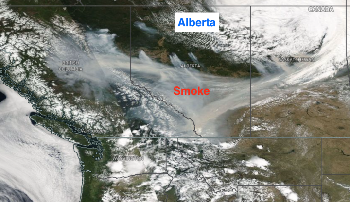
During the last few weeks, large fires have initiated and grown over northern Alberta, resulting in massive smoke plumes (see the image below from one week ago). Here in Washington State, we experienced a few days of smoke aloft from these fires last week.
I have received a number of emails asking whether such Alberta fires are unusual for this time of the year and whether global warming (climate change) could be the cause.
In addition, several media outlets have published headline articles about the topic, suggesting that human emissions of greenhouse gases were the main cause.
It turns out that reality is more complicated.
May is typically the biggest month for Alberta wildfires, there is little upward trend in Canadian wildfires, and anthropogenic greenhouse gas emissions are a very small part of the story.
Canadian Wildfire Statistics
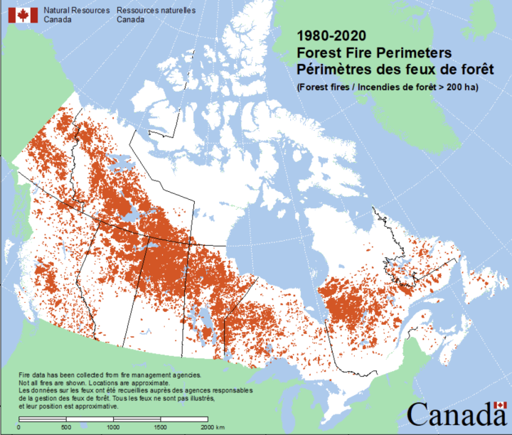
Based on an official Canadian government wildfire database, here is a map of Canadian wildfires from 1980-2020. Alberta wildfires are generally found over the northern half of the province, which includes large areas of boreal forest and grassland.
What is the long-term trend of Canadian wildfires? Increasing due to global warming?
Perhaps surprising to some, the answer is no (see below).
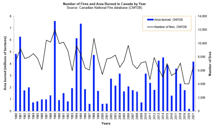
For all of Canada, the number of fires is DECREASING, and there is no obvious trend in the area burned.
What about Alberta, where the current batch of wildfires are burning?
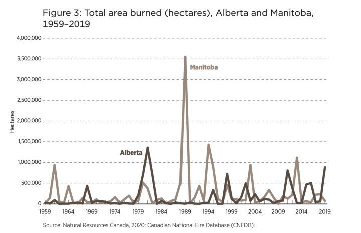
Lots of variability but little upward trend (see below). The biggest fire was in the early 1980s.
The lack of a long-term trend in wildfires is important: one WOULD expect an upward trend if global warming/climate change was a significant contributor.
Some folks have argued that having big Alberta fires in May points to global warming. They suggest that it is warming so fast that wildfires are occurring early!
But folks making such claims need to look at the data. Historically, May is the month of the most frequent wildfires in Alberta. (a graphic from a paper on trends in Alberta wildfire below).
Furthermore, many of Alberta’s great wildfires occurred in May, such as the huge Fort McMurray fire in early May 2016 and 2011 Great Slave Lake fire of 2011.
But why is May such a big month for northern Alberta wildfires?
It has to do with surface fuels. After a long, cool/wet winter, there are a lot of dead fuels (e.g., dried grass, annuals) from the previous year that are on the ground after the snow has melted. Such light fuels dry very quickly during the first warm weather and are ready to burn in early May.
But the optimal burn season is limited in time. Only a few weeks later, there is a greening of the surface vegetation (grasses start to grow, annuals sprout leave) and such greening REDUCES the flammability of the surface fuels. Which side would you expect to burn in the picture below?
There is a short favorable May window for large Alberta fires before the greening. But to take “advantage” of it you need favorable drying conditions, which are associated with a strong, upper-level ridge of high pressure over the region. And strong winds and lightning are favorable as well.
Furthermore, rainfall peaks during the summer (see monthly precipitation in Edmonton below).
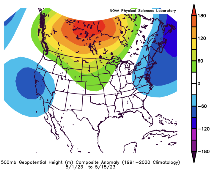
The setup for the fires earlier this month was nearly perfect. In early May, an intense ridge of high pressure developed over southern Canada (see a plot of the difference from normal heights at 500 hPa pressure below for 1-15 May). Red and orange indicate MUCH higher than normal pressure in the lower atmosphere (around 18,000 ft).
Such high pressure resulted in intense drying and warming that helped dry the surface vegetation before greening occurred. There is no evidence that such a pattern is the result of climate change.
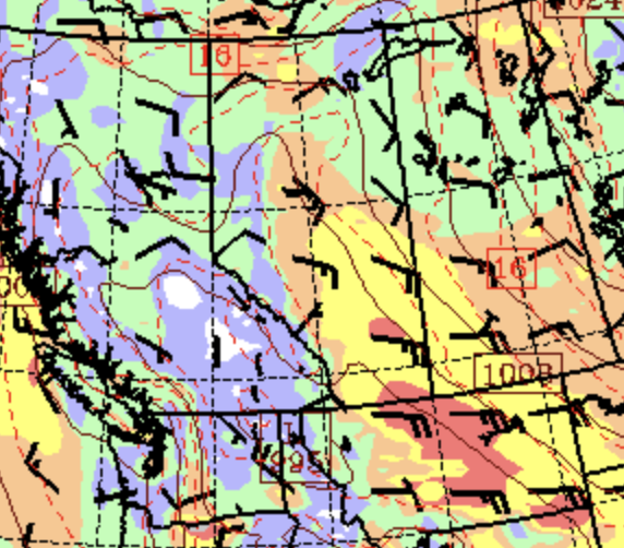
There were periods of strong, dry winds in early May due to the large pressure gradient at the edge of the high pressure at lower elevations (see example below on May 6). Strong wind is a primo accelerator of fire.
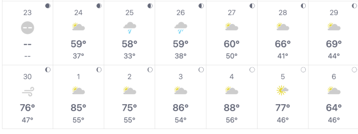
You can understand the situation by looking at the observed weather at Edmonton Airport from late April to early May (below). Rainy and around 60F in late April, then rapid warming and wind on April 30th with a jump to 85F on May 1, followed by 86 and 88 on May 3-4.
Perfect weather to dry out the surface fuels, followed by lightning at the high pressure shifted eastward. Human ignitions are also distinct possibilities.
In summary, there is little evidence that the Alberta wildfires represent a climate event.
Intense drying weather occurred exactly when the surface fuels were most vulnerable before greening. May is typically the month of the biggest Alberta fires for a reason and the smoke that reached the Northwest aloft from the fires was simply the result of a favorable wind pattern aloft (easterly flow), not the results of a slowly warming planet.
__________________
Note: I will do a special online Zoom session this Saturday (May 27th for my Patreon supporters). Will talk about wildfire meteorology and answer your questions.





Judging from the map of fire area, it would appear fires occur on a regular basis. I knew that was true of Mediterranean climates, but not boreal forests.
Indeed, many boreal species are specifically adapted to fire, for example the cones of jack pine are closed until sufficient heat melts the resin allowing them to open and release seeds into the newly burned area. Aspen roots have hundreds of adventitious buds per yard / meter waiting to create a carpet of new sucker growth if the fire does not burn too deeply. Even lowland swamps and bogs will burn infrequently – you can find charcoal in the upper soil layers in essentially all parts of the boreal forest.
The smoke has been choking thick in Eastern Colorado the past three days.
A storm is forecast for the Front Range tomorrow, which should clear the skies of smoke.
Good news.
Are the Miller moths abundant there like they are in the Front Range?
I’ll be happy to see the smoke and moths go.
Yep, the moths are still around. Its been quite a few years since they’ve been this many.
Must be climate change.
Heh. Yup. The climate was definitely changing back in the mid-1960s when I was a teenager in Denver. We had a Miller Moth infestation you couldn’t believe. Sneaking in through sealed casement windows. Sucking them up with the vacuum cleaner hose. Good times! 😉
Thank you Cliff very helpful.
As the headline mentioned, during an election year in a resource-dependent province, the talk of climate change is off the table. None of the parties has proposed any new carbon taxes or major environmental initiatives because it’s aware that these would cost it votes. This is another reminder of the low priority that people in general attach to climate action regardless of where they live.
The fires are originating in the marginal lands, in the increasingly fragmented regions. A general trend of increasing fire risk should be anticipated. A no-trend or low trend may indicate a moderating effect from climate.
The burning of the marginal terrain in the newly fragmented catchments is an ecosystem forcing, whereby edges are dry and drained, beaver extirpated; fungal networks gone, invertebrates and bottom feeders, missing. The forest edges like a drying crust, with the isolated patches like crispy croutons.
The only option for the forest is to oxidize when its biology is deceased. It is for survival. Whether over-mature, or unnaturally dried. Mono timber plantations too. Like a frost-bitten toe, it must be removed
Fire risk is mutli dimensional – it is not surprising for the ecosystem to burn the marginal wasted and wilting bush. Temperature, wind, and recent rain only tell a small party of the story. The condition of the landscape is of paramount consideration.
Climate fanatics distract from such matters, by their reductionist logic and raw unabated ignorance.
https://www.arcgis.com/apps/dashboards/3ffcc2d0ef3e4e0999b0cf8b636defa3
Very good analysis of Canadian weather patterns and fire properties Thank you
Also noteworthy is how dry this year’s spring was in Alberta. The western CONUS has very similar weather with western Canada. March was extremely cold; snow covered my lawn from 26 out of the 31 days, which is something I’ve never before witnessed in my lifetime. April was also cold; a very strong blizzard struck April 3 and April 4. The rest of the month stayed relatively cold with a few high pressure systems causing occasional unseasonable warmth. May seems to have reversed that trend. We’re having our warmest May since 1994 and little precipitation has fallen. Overall though, I think it balances out the extremely cold conditions seen early on in the spring. I’m hoping this summer is cool and wet. El Ninos usually promote cold and wet conditions for CONUS.
Particularly when there is no such thing as a climate event.
The smoke has been very bad for a long time even down in southern Alberta. On the PM2.5 scale, we hit 477 out of 500 last week…not fun.
However, lets not count out the number of wild fires caused by ‘man’, quads, cigarettes etc….yes, lightning causes a lot, but so do stupid humans
caused by ‘man’ , like government ’employees’ ?
There you go Cliff. Bringing facts, data and logical thoughts into the discussion and completely annihilating the media’s crisis message. Way to go!! That is not sarcasm; that is full, unequivocal support.
Meanwhile, over at Cliff’s site, I see his data has figuratively set several excitable commenters’ hair on fire.
Seems that Cliff is Charlie Hebdo to “settled” climate science.
Meanwhile in Bend, Oregon, prescribed burns were postponed this week due to wet conditions. Hard frost last 2 nights. 61″ base at Mt. Batchelor. Ski season has a ways to go.
Could provide a link to his site? Can’t find it on Google and it sounds like a must read. Thanks in advance.
The link is right below the title at the head of the post. That is where links to the authors’ own sites (if they have them) are always placed in WUWT postings.
Thank you.
Mr. said: “Meanwhile, over at Cliff’s site, I see his data has figuratively set several excitable commenters’ hair on fire. Seems that Cliff is Charlie Hebdo to “settled” climate science.”
Here is an example from that blog:
I’ve been playing with ChatGPT lately asking it a number of climate related questions, just to see how it responds. And so I asked ChatGPT a question related to the assertion made above. My question reads as follows:
“What was the concentration of carbon dioxide in the earth’s atmosphere during the Roman Warm Period?”
ChatGPT’s response:
———–
“The Roman Warm Period, also known as the Roman Climatic Optimum, is a term used to describe a relatively warm period that occurred in Europe and the North Atlantic region roughly between 250 BC and 400 AD. However, direct measurements of carbon dioxide (CO2) concentrations in the Earth’s atmosphere were not available during that time as the technology for such measurements did not exist.
Scientific methods to directly measure atmospheric CO2 concentrations became available in the late 1950s with the establishment of the Mauna Loa Observatory in Hawaii. The continuous monitoring of CO2 concentrations at Mauna Loa and other locations around the world has provided a detailed record of atmospheric CO2 levels since then.
Based on ice core data and other proxy records, scientists have reconstructed past CO2 concentrations for periods before direct measurements were available. However, these reconstructions are associated with uncertainties and limitations. According to available scientific research, the pre-industrial CO2 levels during the Roman Warm Period were likely around 280 parts per million (ppm) or slightly lower. It’s important to note that this estimate is subject to some degree of uncertainty.
By comparison, prior to the Industrial Revolution, CO2 concentrations remained relatively stable for thousands of years, fluctuating between approximately 260 and 280 ppm. Since the Industrial Revolution, human activities, particularly the burning of fossil fuels, have significantly increased CO2 emissions, leading to the current concentration of CO2 in the atmosphere being over 410 ppm as of 2021.
Keep in mind that the Roman Warm Period was driven by various factors, including natural climate variability, solar radiation, and regional factors, and the CO2 concentration alone does not provide a complete picture of the climatic conditions during that time.”
———–
I find ChaGPT’s response quite interesting. In this modern age of directed artificial intelligence which relies upon the prior writings of today’s mainstream climate scientists for its analysis of climate issues, how could anyone — let alone a pseudo-human A.I. chatbot such as ChatGPT — believe that various factors including natural climate variability, solar radiation, and regional factors can affect climate; and further, that the CO2 concentration alone does not provide a complete picture of the climatic conditions occurring in any time period whatsoever, let alone the Roman Warm Period.
Thank you for this info Beta Blocker.
IMO, the only thing “artificial” about AI bots such as ChatGPT is the “intelligence” they serve.
What they really provide are regurgitations of what self-appointed human activist “fact-checkers” feed them.
Wikipedia has been rife with these sorts of treatments for decades.
And who in their right mind would rely for accurate information on a single entry from Wikipedia?
There’s always good news if you look for it
Ozone Treaty Delayed Arctic Melting by 15 Years
The Montreal Protocol was intended to save Earth’s ozone layer, but it also helped slow global warming and delayed the melting of Arctic sea ice
https://subscriber.politicopro.com/article/eenews/2023/05/23/ozone-treaty-delayed-arctic-melting-15-years-00098259
Ben
You are a retard. Global warming is changing almost completely naturally.
In 1950, the Wisp Fire in Northern Alberta, ultimately of about 1.5 million ha, started in early June.
I’ve recently came across a very useful website giving actual data worldwide, including wildfires, as well as a lot of other things:
https://earth.nullschool.net/#current/wind/surface/level/orthographic=-124.49,47.50,1105
Activating the button below left “Earth” show the data menu.
To see the data on wildfires, one has to activate the mode “bio” and then activate the “annotation” = Fires Right now, the situation is not so bad in Alberta anymore.
I wish everyone lots of fun …
How many wrongs here and working on the basis that even just 2 don’t make a ‘right’ where the he11 are we headed’
Oops, I just said.
1/ The fire number/area graph
We’re told that the number of fires is going down a ‘no obvious trend’
What is stopping anybody working out a trend?
I did – just by eyeballing the graph into Excel and I got a near perfect Flat Line trend
IOW, The burned are is averaging the same but the number of fires is going down
Does that not mean that The Fires Are Getting Bigger?
Is that supposed to be good news?!!!????
(Somebody lied by omission here)
2/ We’re told that the area is vegetated with ‘annual plants‘ (grasses)
Excuse me but wtf are they doing there.
Annual Plants are NOT the default vegetation on this Planet and never have been.
People put Annual Plants in the ground. The default vegetation for Earth is perennial plants, especially trees.
3/ All throughout this spiel we’re given the impression of a landscape covered by, and commentators have mentioned, ‘Forest’ or Boreal Forest. Supposedly what Canadia is famous for.
Point Arising: Annual Grasses are not = Boreal Forest
4/ We’re shown the annual rainfall graph for Edmonton
Good Grief, what sort of meteoroligist or 15 year old kid does not recognise the rainfall pattern of A Desert = low overal amount and occuring in short sharp bursts only 4 or 5 days per month?
5/ Google maps is your friend – so off I goes to Edmonton and ‘luck of the poorly aimed dart/arra, lands me on Hwy 16A to the west of the city
Holy cow, what a perfectly hideous burnt out bleak and ugly place.
At all times of the year, except July/August when the fields burst into epic greenery then, by September, it’s all gone.
Into huge industrial-looking buildings on the far horizon – presumably that was forage for livestock of some sort = gotta be cows
Errrm excuse me again, why do we not see any cows out in the haha fields?
No matter, that must just one place – my arra missed the (forest) bullseye so let’s go further along Hwy 16A and see what we see.
There is A God and if (s)he’s on anybody’s side, it’s mine today…..
Here’s another point on Hwy 16A – in Jun ’22
There’s the Annual grass gathered up into bales. And huuuuuge heap of ‘something’ = muck from the feedlot?
Go there and look around
<Weep for the cows and also, Planet Earth>
btw: That place is The Casue of the CO2, NOT the result. Also the planet destroying “3 month growing season” as seen in close examination of Keeling
Except that along Hwy 16A, they knocked that down to a 2 month growing season.
I’ve lived in Alberta for 30 years, relatively close to where the wildfires are now. Cliff Mass is right. If we’re getting fires, it’s almost always in May. We had a mild, dry winter this year, and high winds and unusually warm weather in May. Perfect conditions for fire. The last few years though have been wetter than usual. We probably haven’t had a.drought in a decade, which is unusual for this area. Last year at this time it was very wet and cool. It warmed up in July and stayed warm all summer, creating perfect conditions for record crop yields.
All this intricate analysis, and no one has mentioned the latter day arsonists. Just search the Canadian press, it’s a massive problem. How do you get 110 separate fire seats in a few days as reported a few weeks ago?
caused by ‘man’ , like government ’employees’
It seems that when and where ever wildfires break out it encourages the local arsonists to come out and practise their ‘skills’.
This is why CO2 isn’t the cause of forest fires.
Great analysis Cliff!
According to the CBC , the Alberta wildfires are caused by fossil fuel CO2 emissions. The study cited is using SSP 8.5 models.
– – – – – – – – –
Rise in extreme wildfires linked directly to emissions from oil companies in new study
Researchers set out to clearly quantify connection between companies, emissions and climate events
https://www.cbc.ca/news/canada/wildfires-climate-change-carbon-88-1.6852178
– – –
Quantifying the contribution of major carbon producers to increases in vapor pressure deficit and burned area in western US and southwestern Canadian forests
Increases in burned forest area across the western United States and southwestern Canada over the last several decades have been partially driven by a rise in vapor pressure deficit (VPD), a measure of the atmosphere’s drying power that is significantly influenced by human-caused climate change. Previous research has quantified the contribution of carbon emissions traced back to a set of 88 major fossil fuel producers and cement manufacturers to historical global mean temperature rise.
https://iopscience.iop.org/article/10.1088/1748-9326/acbce8
It’s not just Alberta. Just about every spring the Wisconsin DNR issues a high fire hazard warning in late April or early May. They remind use that we must have a permit to do any outdoor burning and burning is prohibited when a warning is in effect. Usually the warning expires soon after the first couple of rain storms as vegetation rapidly greens.
Alberta’s worst wildfire, the Lac La Biche fire, came on May 19, 1919. Five million acres burned, about twice the acreage of the current fires. The 1918-1919 winter season had relatively light amounts of snowfall and a warmer spring than average brought little rain. That sounds like just what we saw with the current fires. Odd how over 100 years of climate change hasn’t changed the weather one iota.