Paul Dorian
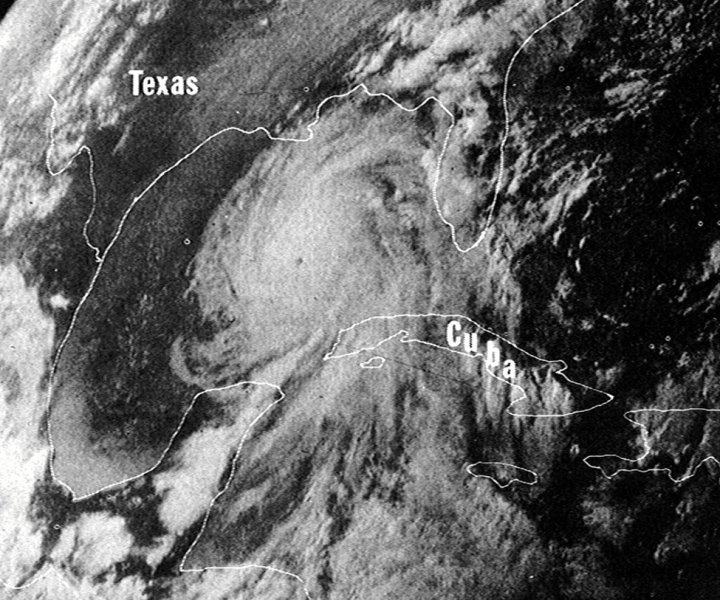
Hurricane Camille on August 16, 1969. Image captured by NASA’s ATS III satellite.
Overview
1969 was a remarkable year and will be long remembered as the year when man first walked on the moon, the Miracle Mets shocked the sports world, and the Woodstock Festival took place in upstate New York. It will also be remembered as the year when a major hurricane –Hurricane Camille – struck the United States as a category 5 storm and the second most intense tropical cyclone on record (only the 1935 Labor Day hurricane had a lower central pressure at landfall). Hurricane Camille made landfall in Mississippi and wreaked havoc from the Gulf States to as far inland as the Mid-Atlantic with widespread flooding, record rainfall, and it cost the lives of several hundreds of people along its path of destruction.
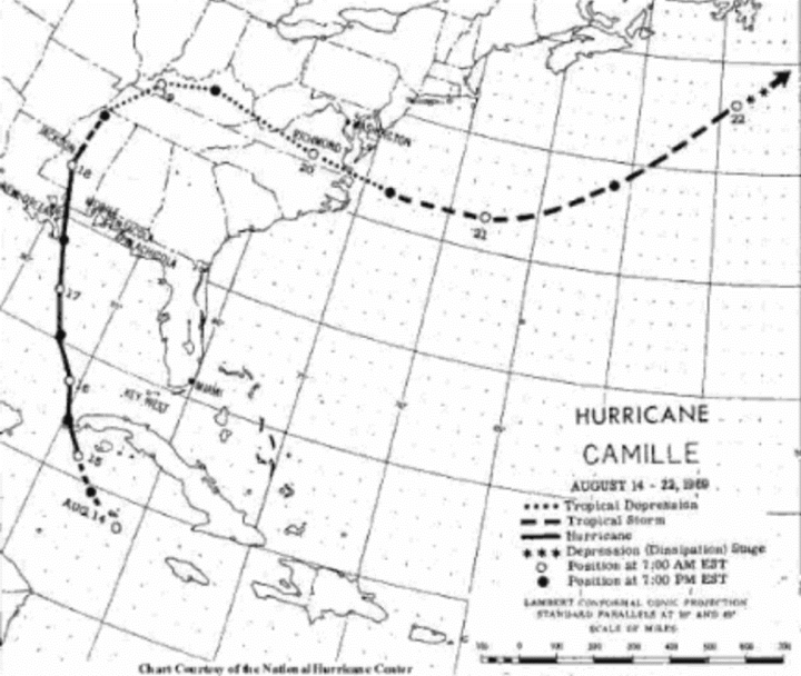
A chart by NOAA from 1969 with the path of Hurricane Camille; Credit NOAA
Development stage
The first satellite image was taken on April 1, 1960 (TIROS) and weather forecasters knew that one of the best uses of this newly introduced tool would be the ability to monitor tropical waves out over the open waters of the Atlantic and Pacific Oceans. Indeed, with the usage of satellite imagery, forecasters first noted a tropical wave off of the African coast as early as August 5th, 1969 and this wave moved westward out over the open tropical Atlantic. Satellite imagery then showed the system crossing over the Leeward Islands by the 10th of August still with no apparent circulation, but that began to change a few days later. By the 14th of August, Air Force reconnaissance aircraft sent into the disturbance picked up a central pressure of 999 millibars along with 55 mph surface winds, and satellite imagery showed much more in the way of circulation with numerous bands of heavy rainfall. It was at this point that the tropical system inherited its name of “Camille” having reached tropical storm status.
Camille did not remain a tropical storm for long as it had favorable conditions for intensification by the middle of the month of August in 1969. The storm moved slowly northwestward and its central pressure continued to drop. By August 15th, Camille had reached hurricane status as it headed towards Cuba with winds gusting up to 115 mph. Camille passed over western Cuba as a category 1 hurricane and produced 92 mph winds and 10 inches of rain.
By the 16th of August, Camille had passed Cuba and pushed over the warm waters of the Gulf of Mexico which helped to continue its intensification. Another Air Force reconnaissance aircraft was flown into the eye of Camille at this time and a central pressure of 908 millibars was recorded using dropwindsondes. Hurricane Camille was now headed right towards the northern Gulf coastal region in a north-northwestward direction at 14 mph and it was being called a “small but dangerous” storm by the US Weather Bureau. Hurricane watches on this day were put up stretching over 400 miles from Biloxi, Mississippi to St. Marks, Florida.
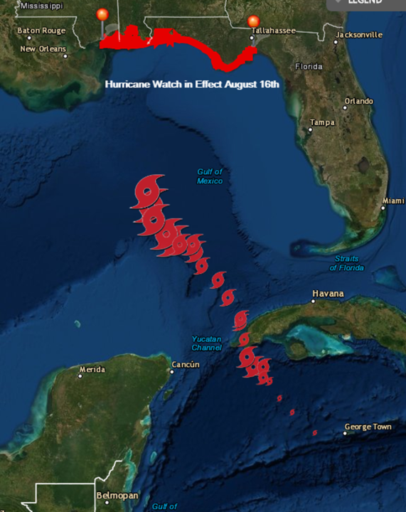
Hurricane watches were in effect on August 16th across a wide portion of the northern Gulf coast as Camille crossed over the warm waters of the Gulf of Mexico; Source NOAA/NWS
Landfall
On August 17th, Hurricane Camille reached category 5 status and was located about 250 miles south of Mobile, Alabama. Gulf states were now in crisis mode in preparation for landfall in what had become a monster hurricane. The last Air Force reconnaissance aircraft readings were made on the afternoon of the 17th and a central pressure of 901 millibars was measured along with a maximum surface wind gust of over 200 mph. There was only one other time that a central pressure had been measured this low, in the 1935 Labor Day hurricane which ended up crossing over the Florida Keys between Miami and Key West. As landfall approached in the northern Gulf coastal region, the easterly winds ahead of Camille generated a storm surge through the marshes of southeastern Louisiana. Meteorologists warned that “never before has a populated area been threatened by a storm as extremely dangerous as Camille”. A mass evacuation emptied the coastal towns all along the Gulf coast and those that stayed likely perished during the storm (there were rumors of “hurricane parties”, but there weren’t any survivors to recall them).
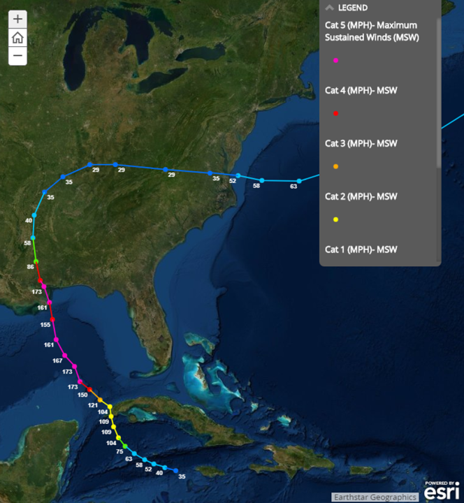
The track of Hurricane Camille along with updated wind speeds; Courtesy NOAA, ESRI, Earthstar Geographics
Hurricane Camille made landfall on August 17th at about 10:30PM (CT) passing over Clermont Harbor, Waveland and Bay St. Louis in the state of Mississippi. In 1969, it was only the second category 5 storm to make landfall in the US in the record-keeping era. Numerous weather stations that were supposed to record pressure and winds were destroyed during the storm and many of the records are only estimates and range up to 200 mph in wind gusts. Maximum surface winds were calculated to be near 201.5 mph near the center of Camille on the afternoon of August 17th. The highest actual measurement on a wind instrument of 172 mph was found on an Esterline Angus wind speed recorder and was before the instrument gave out due to a paper jam. Maximum sustained winds will never be known for certain. Catastrophic flooding took place from Louisiana to Florida with the tide reaching a maximum of 24.2 feet above mean sea level in some spots.

Photo of the flooding from the University of Colorado/CIRES 30th anniversary retrospective
Devastation far inland with catastrophic flooding in Virginia
Camille weakened to a tropical depression as it passed through northern Mississippi and into western Tennessee. It then took a turn to the northeast through central Kentucky and then eastward through extreme southern West Virginia and southern Virginia. By the 19th of August, atmospheric conditions were coming together for extreme rainfall and local geographic features were enhancing chances for catastrophic flooding in the eastern slopes of the Blue Ridge Mountains – but few were prepared for what was about to take place. Specifically, the remains of Camille were moving into an area where there was tropical air in place along with an existing backdoor cold front at the surface and an intensifying jet streak aloft. In this part of Virginia, there is a narrow valley with steep ridges and an upsloping wind amplified rainfall amounts. The combination of this extremely unstable atmosphere and local geographic features was resulting in historic and deadly flooding conditions.

Rainfall amounts were disastrous across the northern Gulf coast and in the eastern slopes of the Blue Ridge Mountains; Credit NOAA
Rainfall amounts of more than 26 inches occurred in the mountain slopes between Charlottesville and Lynchburg, Virginia in a 12 hour period. Nelson County, Virginia recorded 27 inches of rain with reports that the rain was so heavy there were birds drowning in trees. [A post-storm “reanalysis” by NOAA suggests over 30 inches of rain fell in as little as eight hours in some spots]. Survivors recall a night between the 19th and 20th of August that was filled with thunderstorm after thunderstorm and lightning so fierce “it was like daylight and the lightning didn’t flash, the sky just literally stayed lit”. A total of nearly 3800 landslides were calculated within Nelson County, Virginia alone using LiDAR scans and 123 of the 153 fatalities in the state during this storm took place in this particular county. After Camille, the landscape had changed so much that topographical maps were obsolete. To this day, hillsides still remain bare with exposed rock where mudslides ravaged and stripped the forest away. The rainfall tripled the state of Virginia’s record and has not been broken since. (Credit to Jason Elliott (NWS, Sterling, VA) for much of the information on Camille and its impact on Nelson County, Virginia).
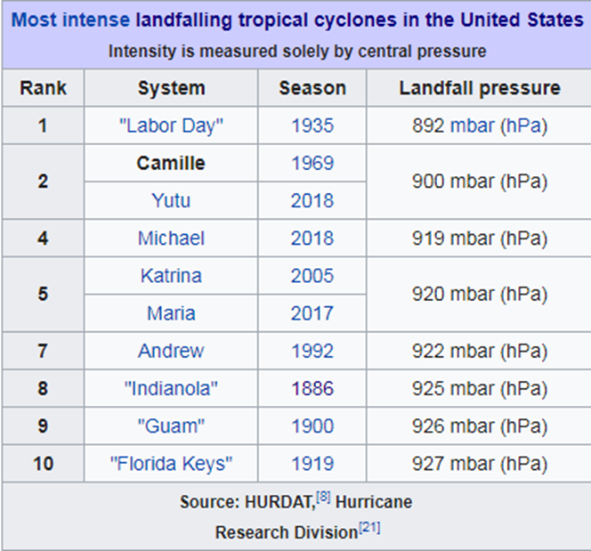
Hurricane Camille was the second most intense landfalling hurricane in the US in terms of central pressure; Credit NOAA
Final Notes
Hurricane Camille will always be remembered as one of the most devastating storms in US history and one of only four category 5 hurricanes to strike the US. In addition to the Hurricane Camille and the 1935 Labor Day hurricane, there have been two other category 5 hurricanes to make landfall in the US and both took place after 1969. Hurricane Andrew struck the southeastern part of Florida in August of 1992 and Hurricane Michael made landfall in October of 2018 across the panhandle region of Florida. In the case of Michael, category 5 status did not come until months later when a “reanalysis” by NOAA increased its winds by 5 mph at landfall near Mexico Beach and Tyndall Air Force Base, Florida compared to the original operational estimate and this increase pushed the storm into category 5 territory.
Meteorologist Paul Dorian
Arcfield
arcfieldweather.com
Follow us on Facebook, Twitter, YouTube
On July 29, 1969 I came home from my military service in Germany and was separated from the US army. So a very momentous time for me. I don’t remember the hurricane though
In 1969 I was about 75 feet up in an Air Traffic Control tower in DiAn Vietnam, when a typhoon went through. Max sustained winds of 111 knots (about 127 mph) and about 2 feet of rain in 5 hours. I remember this typhoon.
We are a special cohort from that time. My home town Facebook page posts about those that didn’t return very sad
As does mine
I was sitting in Phu Bai, South Vietnam, in August 1969.
I recall a typhoon in 1968, while I was staying a few miles south of the An Khe pass, South Vietnam, where it rained 22 inches in 24 hours. That’s the most rain I’ve ever seen.
I remember it well. I was living just outside of Memphis. It rained so hard I could not see my hand at the end of my young arm.
My aunt (nurse in the Air Force) got transferred to Biloxi 2 weeks before Camille hit the coast. She was an avid photographer and had quite a slide show from the aftermath. Boats were pushed 3 miles inland and had many other amazing shots. She went on to go to Clark and a couple of places in Vietnam. In fact she got transferred all over the place but never was sent to Europe where she really wanted to go. She is still going at life in Wyoming. Made it to full Colonel and is an amazing person.
In June 1969 I was a newly minted Ensign. My wife of 53 years and I were married in the Naval Academy Chapel. I was subsequently assigned to the Naval Air Basic Training Command in Pensacola. Two days before Camille hit I helped move T28 training aircraft into hangars while other planes were flown out of state. The day before Camille hit I was Officer of the Day for the Aviation Officer Candidate’s barracks at Saufley Field. The barracks looked like a giant Holiday Inn. Lots of plate glass windows that needed to be taped to prevent flying glass if they broke. I had left my new bride to secure our apartment. I had continuous requests from the AOCs to be excused so they could help their wives and girl friends prepare for the storm off base. Keeping them on task was like herding cats.
Saw a few motorcycles stowed in some of the rooms. Also saw a small aircraft under construction in one. VW air cooled engine on an aluminum frame at that stage. No wings.
We eventually got the barracks ready and I got home to help my wife. We filled the bathtub so we could flush the toilet if we lost water pressure. There was not much else to do. Fortunately for us Camille hit in Mississippi. It passed close enough to suck all of the water out of the nearby swimming pool though.
And this happened in the climate pattern that gave rise to “ the Ice Age is Coming” scare. Shoehorning facts into a narrative gets a bit harder if one uses all the evidence.
Meantime we have NOAA’s increasingly questionable 2022 “above normal” Atlantic Hurricane season forecast which through August 16 has less than 20% of the ACE compared to the average of all seasons from 1991 to 2020 and with only 3.25 days of storm activity compared to 13.8 days for an average season.
Not looking good for NOAA’s forecast during our “climate emergency”.
I lived near the Gulf for several years and it usually wasn’t until around the end of August before one got too worried about developing tropical storms.
Anyway, we received about 3″ of drought rain today in my part of Colorado. Wettest drought I’ve ever experienced.
Ha, call that a wet drought! You should be here in the UK our wet droughts are so bad, farmers are celebrating a wonderful harvest period of dry warm weather. Now the rain has arrived just as all the wheat is safely gathered in. Our wet drought was so severe, we even had a patch of dry grass on the lawn.
I do not wish to be too dismissive of weather events here in UK. But when the most shocking image presented of the expected devastating rain following our 30 deg C heat wave, is a puddle around a traffic island what can you say. The puddle which only sits there because the council have not cleared the run off drains. You just know and can see hype has taken over from rational analysis these days. I blame Covid or was it Brexit?…..or maybe Putin?
I blame the growing fraction of young people in (and in charge of) the media who have only ever led comfortable, pampered lives and yearn to live-action role-play adversity to bring some drama into their dull lives.
NOAA’s National Hurricane Center has nothing to do with warmunism. They just look at ongoing weather patterns and using their models developed over more than half a century attempt predictions of generalized storm activity, not trying to scare people about climate.
As for your crowing about little activity so far, historical data shows that the second half of August has more Atlantic hurricanes than the months of June, July, and the first half of August combined … and the month of September dwarfs the entire month of August, and October has about as many hurricanes as the the entire month of August.
Long time Florida residents like me know that you never relax your concern over tropical weather until November, which is still a long ways off.
The two Atlantic hurricanes that made direct hits on my home were Wilma – October 2005 – and Irma – September 2017. Both were Cat 5s as they approached Florida, and both hit my house as Cat 4 storms (my next door neighbor’s wind monitoring station disintegrated at 130 + mph – the storm blew off about 1/3 of my bolted on hurricane shutters.
Only non-Florida nimrods like you crow about not getting hit with a big one by the middle of August.
Don’t worry, they are bound to spin a “below normal” season into a “bad news, worse than we thought, we’re all doomed” scenario. Probably that the spare energy is “hiding in the ocean and will be released next year”. Just you wait and see.
I actually experienced Camille 2 times that August while working on an oil tanker going through Da Guf and docking at a refinery ~80 miles upriver from N’awlins.
The wave heights were indescribable while we were at sea, but that was nothing compared to the wind as night time progressed.
The refinery manager wanted the captain to disembark from his terminal lest loose barges ram the naptha laden ship.
Captain refused.
All the Old Hands scooted downtown to spend the night safely at the local cat house.
Belatedly, the cook tried to join them, but the wind pushed against his bicycle so ferociously that he was actually going backwards. (I realize that seems physically impossible, but I witnessed it).
Undeterred, he tried walking, pulling himself hand over hand down the gangway railing until – exhausted after travelling ~200 feet – he returned to his cabin and spent the night praying.
Day later, coming downriver, it was COMPLETELY flat landscape as far as the eye could see.
Not a tree, nor bush, nor structure was standing …
as if some giant waved his hand and completely flattened everything.
Passing through N’awlins, about a dozen huge ships were aground in the river – tossed like toys – as tugboats were strenuously pulling them back into deeper water.
If there is ever a storm – anywhere – as monstrous as Camille, my sincere condolences go out to all having the misfortune of feeling the impacts.
I was at Biloxi AFB for 6 months of training a year after Camille struck. We heard lots of stories of “hurricane parties” that ended with people drowning in their attics. There were essentially no structures left standing for about a mile from the beach, but one that I remember vividly was a boat (shrimp boat) stuck between a house and a detached garage over a mile from the beach. Some of the airmen that I met told of making rescues during the storm using armored cars as ambulances since they were heavy enough to keep from blowing over.
1969 was a remarkable year and will be long remembered as the year when . . .
I got married. {Sorry — could not resist.}
Missed the impacts because we married on July 12th in Atlanta, left Atlanta, in a car, for Pennsylvania 10 days later. Left PA for Iowa 2 weeks after that. I do not remember having a television when first moving into our first apartment.
By a month, we would have had a very different trip.
It’s okay, John F.. We’re family, here (well….. *cough* some of us are…..). And you miss her dreadfully….. 😔
Still praying…..
Take care.
I drove the Gulf coast from New Orleans to Florida on the way to a vacation in the Keys in 1970. The devastation was still apparent with building foundations and concrete slabs and piles of rubble all that remained along much of the highway. I recall that a Volvo dealer had their entire inventory totaled by flood damage and Volvo took the opportunity to tout the Volvo Hardtop sedans by stacking 7 of the ruined cars on top of each other. You can find the ad on-line by searching “stack of Volvos”.
And on this anniversary there is not a single tropical cyclone in evidence anywhere on earth:
Hurricane & Tropical Cyclones | Weather Underground (wunderground.com)
I was in the Navy and living in Arlington, VA that summer. I remember a flash flood that must have been the tail end of Camille. At the time I didn’t make the association with the hurricane.
Historical records, some going back centuries, when people did not have the equipment to give today’s detail may give us suprising insights. People have for millennia carefully observed weather because of the importance for farming. I stumbled across another study today of observations needed for shipping between 1652 and 1791 from Cape Town.
Colony founder Jan van Riebeeck “took a personal interest in understanding the Cape climate and its implications for local shipping”, they say, and asked for daily weather to be included in day registers, first used to capture the details of ships at sea. As a result, weather observations were captured from 1652 through until 1791, and with remarkable consistency.
Scribes were discouraged from varying the way the records were kept, the researchers say, so terminology was standardised. The importance ascribed to the data saw accounts that usually included changes in wind direction and force, even overnight, plus details of cloud cover and precipitation.
Recording the weather was “a daily ritual with global implications for company trade”, say the researchers.
https://www.businessinsider.co.za/colonial-voc-weather-records-show-cape-town-was-pretty-wet-in-1787-2022-8
This post brings a few things into sharp focus.
i) there were terrible hurricanes before humans significantly elevated CO2 levels. There have always been hurricanes and there always will be. To listen to some folk, you would think that they honestly believe that if we achieve the fabled “Net Zero,” then such things will no longer occur. Not only that, but they seem to think that hurricanes are something new, a symptom of humanity’s war on Gaia.
ii) We will be a lot less resilient to hurricanes like this if we are living “Net Zero” in 2050 than we are now.
Must be a slow hurricane season trying to keep the fear levels high by showing long ago hurricanes. Find it odd that the legends in the graphs don’t match what is being shown.
You are not making sense. What graphs?
Reminds me of a friend who shot a bear that was just barely legal size (103 lbs, shame on him) but it was the first he had ever seen. His “reanalysis” months later has it now over 150 lbs. That had to be a record breaking “reanalysis” in my book!
Adding 5″ or so to a fish is about as common among some fishermen as record keeping and “reanalysis” at NOAA.
I remember Camille. Was 7 and we lived in north Pearl River County MS, eye passed over us.
August 24th marks the 30th Anniversary of Hurricane Andrew’s devastating landfall on south Florida. Can we prevail on Mr. Dorian to do a similar write-up for that Cat 5?
BTW the table he uses credited to NOAA is actually found here:
https://www.wikiwand.com/en/Hurricane_Camille
and inexplicably includes Typhoon Yutu (2018) from the western Pacific, which did NOT make landfall in the US. Sometimes, the Internet fails. 😉
It hit the Northern Marianas which is US territory. But you’re right. Usually when “landfall in the US” is used it’s referring the continental US plus Hawaii.
5/10 occurred after global warming picked up (1992 on)? Hey – If I noticed, you know they will.
I’m a Virginian; used to live in Charlottesville, Va which is in the next county east of Nelson County, Virginia. I’ve spent a lot of time in Nelson County (only a 25 minute drive from Charlottesville).
Camille got hung up in Nelson County. When you drive along one of scenic byways in Nelson, there is a sign alongside the road at one of the overlooks. The sign says that during Camille, that area of Nelson County set and held for years the world’s record for the most rainfall in a 24 hour period. If memory serves, it was 39 inches of rainfall in less that 24 hours.
I had a man from Nelson County who used to work for me. When he was a young boy about 10 years old; Camille hit hardest where he lived. He lost family and friends. Whenever we had a severe thunder and lightening storm with heavy rain, he would just freeze up and start shivering. I asked him what’s going on? He then told me the story of how devastating Camille was to him and his family.
From Wikipedia:
“Hurricane Camille[edit]
On the night of August 19–20, 1969, Nelson County was struck by disastrous flooding caused by Hurricane Camille. The hurricane hit the Gulf Coast two days earlier, weakened over land, and stalled on the eastern side of the Blue Ridge Mountains, dumping a world-record quantity of 27 inches (690 mm) of rain, mainly in a three-hour period. Over five hours, it yielded more than 37 inches (940 mm), while the previous day had seen a deluge of 5 inches (130 mm) in half an hour, with the ground already saturated. There were reports of animals drowning in trees and people who had had to cup their hands around their mouth and nose to breathe.[5]
Mudslide damage in Nelson County after the passage of Hurricane Camille
Flash floods and mudslides killed 153 people, 31 from Roseland, Tyro, and Massies Mill alone.[6] Over 133 public bridges were washed out in Nelson County, while some communities were under water.[7] In the tiny community of Davis Creek, 52 people were killed or could not be found; only 3 of 35 homes were left standing after the floodwaters receded.[6] The bodies of some people have never been found; others washed as much as 25 miles (40 km) downstream along the creeks and rivers. The entire county was virtually cut off, with many roads and virtually all bridges, telephone, radio, TV, and electric service interrupted.
The waters of the Tye, Piney, Buffalo, and Rockfish rivers flow into the James River. There was severe flooding elsewhere in Virginia, such as along the Maury River, which destroyed the town of Glasgow in Rockbridge County.
The James River and its tributaries normally drain Nelson County, but in the face of unusually high flooding from other tributaries such as Hatt Creek (along the James River some 80 miles (130 km) to the east) the James River crested more than 20 feet (6.1 m) above flood stage at Westham, as Nelson County citizens watched portions of houses and other buildings, bodies, and dead livestock flow past. Just a few miles further downstream, the James River crested at the City Locks in Richmond at 28.6 feet (8.7 m) swamping downtown areas and also flooding a substantial portion of South Richmond (formerly the separate city of Manchester[8]). The Hurricane Camille disaster did over $140 million (in 1969 dollars) in damage across Virginia, however in no other place in Virginia was the storm as devastating and deadly as in Nelson County, where one percent of the population was killed and where many bodies were never recovered. Visitors to Nelson County can participate on a self-guided tour of notable locations related to Hurricane Camille. There are exhibits dedicated to Hurricane Camille at the Oakland Museum.”
Yeah, I live just south of Nelson county. Have driven through it countless dozens of times. One can still see the scar of a landslide (on one particular ridge) caused by Camille whilst driving on 29N. Someone once told me that there was some calculation or another that suggested the rainfall was at the maximum amount possible for our atmosphere (or something to this affect)…
rip
(there were rumors of “hurricane parties”, but there weren’t any survivors to recall them).
Ask the local people .
Not everyone who was invited chose to attend .
C’mon man !
I was a kid on vacation in the panhandle of FL when Camille was approaching the Gulf Coast. Our vacation was very short lived at that location because it was unknown at the time where exactly it would come a shore. We ended up going east towards Jacksonville to spend the rest of our vacation. We were all disappointed our summer beach time was cut short unaware of the destruction the hurricane brought a few days later just west of where we were originally staying.
We rode out Camille in a relative’s house. We were fortunate to not sustain any damage but we’re without power for some time. As soon as highway 90 was opened we went down to Biloxi. The destruction was incredible.
i think ryan maue and chris landsea , bill gray acolytes who are not climate crisis evangelists , are still at the national hurricane center , though i imagine they are ostracized
A very few days after Camile passed over the Mississippi gulf coast, my father traveled from Jackson to the remains of Gulfport and Biloxi in a company sedan with a folding table, two folding chairs, an accountant, an armed security guard, and as many boxes of cash as would fit in the trunk and back seat. They would set up the table on the slab remains of local landmarks and hand-out cash to South Central Bell employees who lined-up for interest-free advances and loans. All that was required was a company ID, a few words of what was needed, a handshake, and a signature beside a penciled line in a ledger. The stories he heard, the things he saw in two days.
And today we have politicians who tell us a few centimeters of ocean rise constitutes a worldwide emergency which demands we give up our Constitutional rights.
We had an early summer study there before the storm including a great variety of organisms. Rabbits, raccoons, diamondback turtles, arthropods in temporary ponds, and others with a survey of the extensive turtle grass beds, the only ones in Louisiana. The islands are a remnant of the old St. Bernard Delta, long eroding, somewhat less on the northern end with the old iron lighthouse which survived. The building and pier to it did not. We went back after the storm and found some erosion, but the highest sand due, about 12′ had not been topped although considerably eroded. Breton Island at the south end with heavy wax myrtle shrubby trees was destroyed with pavements of large hard clams from considerable erosion offshore. Apparently the last easterly winds washed out the larvae of a brackish water clam from the Mississippi delta. The erosion along with other lesser hurricanes aided Katrina to do more damage to the island chain with many more washovers, removing the lighthouse.
Unfortunately sand in the river needed there to ultimately protect New Orleans is moving far west to the Atchafalaya,. Water first pushed ahead of the storm allows cyclonic winds to produce big westerly surges through Lake Pontchartrain. A 1915 storm put 13 feet of water in the west wiping out the small town of Frenier.
It’s highly noteworthy how the perspective of professional meteorologists and oceanographers on the historical record of weather very frequently diverges from the present-day narrative provided by academic “climate scientists.”