From the Cliff Mass Weather Blog
Yesterday, around 0400 UTC 15 January (8 PM PST 14 January), there was a massive, explosive eruption near Tonga, in the southern tropical Pacific, about 5642 miles from Seattle (see map).

The volcano was clearly evident in satellite imagery from the massive ash cloud (see below, about 1-h after the eruption)

The explosive eruption created shock waves in the atmosphere (pressure waves) that rapidly propagated away. These waves are evident in some infrared (water vapor channel) imagery as concentric rings (shown below).

The oceanic eruption also pushed away a massive amount of water, which created a tsunami on nearby islands (such as Tonga) and deep water waves that moved away at the speed of a jet plane, reaching the West Coast this morning. This is why some local tsunami warnings went out this AM.
The Pressure Wave Reaches the Northwest
Local barometers indicated a well-defined pressure wave passing over our region around 4:30 AM this morning. Here in Seattle, the University of Washington barometer showed the feature, with an amplitude of roughly 2 hPa (2 mb). The arrow indicates the feature. Very impressive.

So it took about eight hours and 30 minutes to go about 5643 miles–thus a speed around 664 miles per hour. This corresponds to the speed of sound in the upper atmosphere around 30,000 ft. Makes sense.
The water wave moves slower, around 400 mph (and occasionally approaching 500 mph)….so a later arrival was expected. Thus, at Neah Bay, at the entrance to the Strait of Juan de Fuca, the water wave arrived around 9 AM (17:00 UTC as shown on the chart), as indicated by the waviness in the water level after that time. The amplitude of the variation is around 2 feet.

If you really want to be impressed, check out the same figure at Monterey, California. Just wow. The amplitude was up to 3-4 feet.

An amazing event and one that shows how interconnected our planet is–both in the air and in the water.
Impressive natural event. The videos of the initial eruption show a combination of pyroclastic (gas-charged ash) material, the dark eruptive cloud, and steam, the white material. The steam explosions show probable unroofing of magma with sea water contact. Even the steam contains gases and volatiles as it does not dissipate quickly but appears to continue as white smoke. Just another normal event in our planets getting internal heat out of the system.
I
You claim that it’s natural, but Settled Science tells us that we caused it. Repent!
Well they did blame the 2003 tsunami on climate change as I recall. Just saying.
Here is the Tsunami in Santa Cruz
Even Ca Tsunamis are Laid Back
Zig Zag, it looks like your claim it is not a natural event is somewhat in question, in that the Tonganese name for the erupting volcano is: Hunga Tonga-Hunga Ha’apai, which translates to: stay away from that woman, she’s pissed off about something”.
Aren’t they all
And the cause is usually manmade. 🤨😉😚
Mea culpa, Janice.
Aw, Dan…… no, lol. Women (this woman, at least! ) DO get stirred up, in general, more easily than men, by EVERY thing/one.
And that’s what makes us so delightful 😊
Heh. We can’t live with each other and we can’t live without each other.
Yeah, I realize that you knew I was kidding (sort of……..heh), but, it made me feel better to say so. Maybe, I felt compelled to write this qualification because I know or know of men whose wives are a NIGHTMARE to live with…… and their husbands just silently suffer and THAT makes me angry!! At a WOMAN-made cause. Lolol.
And some women like to talk a lot, too, huh?
🙂
If women weren’t like women then life would be no fun. To all women thank you for being the way you are!
To most women.
: )
Just Mother Nature getting her rocks off.
Volcanoes are just Earth popping its zits.
Note that if you reconstruct the time line, this video is all before the big event. The eruption began early in the day (I have seen 4:20 AM reported on GeologyHub) & the big eruption was not until the end of the day (you can see it was just before sunset on visible satellite loops). And after that , Tonga lost internet & no images have come out since. So, the video was not of the main eruption but of precursors earlier in the day
I believe you meant initial eruption, not main eruption. If the initial eruption uncapped the magma, then water flowing into the chamber would trigger a much larger explosion. This would be similar to, but much smaller than, the eruption at Santorini Island in the Mediterranean.
4:20 AM. IIRC, I saw satellite images referring to about 0410 UTC. “4:20 AM” is meaningless to me, as I live in the Eastern Time Zone. (UTC-0500).
Please learn how to tell time to us.
I believe Tonga is UTC+1300. I won’t bother to figure out when sunset was there.
Oh, what the heck. https://www.timeanddate.com/astronomy/tonga says sunset is about 7:25 PM, presumably local time.
Won’t ‘causality’ go in the opposite direction:
=> Volcanic cycles sometimes cause the world’s regional climates to change.
=> Are you stocking your larder in 2025 for the return of the 210 year DeVries volcanic cycle in 2026 in the SE Asian archipelago, which caused ‘the year without a winter’ in 1816?
I think it was actually “the year without a summer” A historical name that (IIRC) gets occasionally debunked and/or rebunked here at WUWT.
Oops! Thx for the correction.
1606 they skated on the Thames.
1396 they couldn’t grow enough food with cloudy skies to survive the Black Plague.
We may get a preview of 2026 from the Tonga volcano explosion. Has anyone heard whether Tonga has survived or sufferred the same fate as the Minoans on Crete (Atlantis?) when the Thera volcano exploded ~1500 BC?
Weather stations in the UK recorded the same pressure wave between 1900 and 2000 UTC.
Yes. The shockwave caused a 2 minibar jump in air pressure recorded on my barometer in the north of England. There was a second, slightly smaller disturbance an hour later and another at about 0100 UTC on sunday
Had a 1 minibar jump in my hotel room nachspiel the other day. The other hotel residents sure took notice…
Have they linked this event to “climate change” yet? I know it might seem impossible but where there’s a will there’s a way. Money helps too.
There’s nothing that the Magic Molecule can’t do!
I guessed rhinoceros. Losing my touch.
Boris Badenov: “Get moose and squirrel!”
Oh they will be on the case expect some peer reviewed papers from the firm anytime soon. In the meantime it’s bad so according to Griff it will be climate change.
“Have they linked this event to “climate change” yet?”
Let’s help them out.
Hmm … acid rain combined with the missing heat in the ocean melted and dissolved the Earth’s crust above that particular spot until the pressure and heat from all past missing heat (from when CO2 levels were much higher) caused the Earth’s core to melt and burst through the Man-Made weak spot?
Caught on camera, an amazing sight to behold.
But lets not forget that this eruption was caused by, er, climate change…..
“A changing climate isn’t just about floods, droughts and heatwaves. It brings erupting volcanoes and catastrophic earthquakes too”
https://www.theguardian.com/environment/2012/feb/26/why-climate-change-shake-earth
The Guardian; always good for a laugh
This goes without saying…
Looking at author Bill McGuire’s profile at the Guardian, he has been making these claims in the Guardian going back to at least 2003. According to his bio (Wikipedia):
In November 2003 he linked global warming to a potential new ice age:
In an August 2007 article he claimed:
Then in April 2008:
In February 2012:
There are plenty others, see here.
At a brief glance the only natural disaster McGuire hasn’t linked to climate change is asteroid strikes.
If this were 50 years ago, the claim would be nuclear testing is responsible for all the same real and imagined disasters.
I can do better than alarmist McGuire…a warmer climate (all our fault) causes the atmosphere to be thinner thus letting in more of those nasty asteroids. Easy, simple sound bit science like that from MSM and the Guardian. It’s ALL our fault. Don’t you know?
Nice research, Alan Watt, CDL7.
one of Britain’s leading volcanologists
And Britain is so proud.
🙄
Scientists now link volcanism to climate change, so it’s clear that volcanoes are an existential threat to our planet.
Since humans can now control our other existential threat (climate change) by increasing tax dollars, it stands to reason that another tax increase can also control volcanoes.
We read about early-morning volcanoes way back in the 1950s. The impeccable source was Pogo the possum.
I certainly heard the explosions here in the North Island of New Zealand about 2000km away for about 10 minutes. Sounded just like distant artillery…very impressive. Didn’t know what it was at the time.
Really? I heard nothing here in North Queensland, which is closer.
Err?
Tonga to North Queensland 4,500 km
I think he forgot the question mark:
“Really? I heard nothing here in North Queensland, which is closer?”
I was reading that it was NOT audible in Hawaii, but it WAS heard clearly in some parts of Alaska, which is 1000’s of miles further away.
The speculation was that some sort of meteorological condition focused or redirected the sound from aloft down to the surface.
I live near Hamilton in Waikato. We heard it as well. If I hadn’t heard it I wouldn’t have believed it.
Me to on Kawau Island North of Auckland
We spend some time looking for further lightening but no clouds etc.
Thought of the WW1 French front barrages that were audible in UK.
Also further south around Wellington. Pheasants carrying on like in an earthquake.
It is being called the loudest sound on Earth since Krakatoa in the 1880’s.
But I am not so sure…the person who they asked had fine hearing back then, but is a little hard of hearing nowadays.
And everything seems bigger when one is younger.
Here in SW Florida, USA, one of my cats woke up briefly, looked around, yawned, and went back to sleep.
How much CO2 was released? is there any sign of a pulse at the monitors in Hawaii?
How much albedo-altering ash has been pumped into the stratosphere?
Would be amusing if it turned out to utterly disprove AGW…
I’m more interested in how much all that ash will cool the South-Western Pacific. What impact will it have on sea surface temperatures and, consequently, on rainfall patterns? Will the area have a cool but dry winter? This may be the start of a very bad year for farmers down under.
One theory is volcanic ash blasted into the stratosphere in the tropics decreases the easterly trade winds ultimately causing an El Niño. So immediate cooling, long term warming.
We could use a large El Nino here in Arizona and the Southwest next winter. Bring it on!
Amen! Bring it on!
More condensation nuclei usually means more rain.
Plus we are way overdue for numerous large eruptions, and this one hardly plugs the deficit. Not that this by itself indicates more eruptions will come soon, but I suspect that it is not random and uncorrelated, like flipping a coin.
More like earthquakes I would think…energy is being (more or less) constantly stored up and has to get released eventually, although buildup of pressure in volcanoes around the world seems to be more episodic, due to the obvious difference between slow constant plate motions steadily building up strain that is released when rocks break, and the bubbling up of gas & magma from the depths of the Earth.
Some have claimed there is or may be a link to the solar cycles as well, with one possible mechanism for this at-first-unlikely-seeming scenario that a decrease in solar magnetic field leads to an increase in cosmic rays impinging on Earth which causes gasses to be released by magma, which increases pressure and hence more volcanic activity. Like shaking a bottle of soda.
Nothing seen (yet). https://gml.noaa.gov/ccgg/trends/monthly.html
My prediction is that there will be a large temperature drop on the UAH lower atmosphere graph in 2022 followed by a drop in the rate of increase in atmospheric CO2 in 2023.
Look at what happenned after Mt Pinatubo.
Erupted in 1991. Rate of CO2 increase dropped in 1992
https://gml.noaa.gov/ccgg/trends/gr.html
This blast was strong but short in duration.
Volume of ejected material being reported is a small fraction of Mount Pinatubo (1991). Maybe 1/7 as much, IIRC.
Wth a VEI of around 5 accordingly early estimates, it is within an order of magnitude of the volume of material released with El Chichón (1982) and with Mount St. Helens (1980) each around VEI5. Helens.
Although as we know from the example of el Chichon, small seeming eruptions can at times have a disproportionate effect if they are very high in SO2.
This eruption released an estimated 400,000 tonnes of SO2:
“Preliminary observations showed that the eruption column ejected a large amount of volcanic material into the stratosphere, leading to speculation that it would cause a temporary climate cooling effect.[38] Later calculations showed it injected an estimated 400,000 tonnes of sulfur dioxide into the stratosphere and was unlikely to have any global cooling effect.[39] Despite this, the eruption can have a cooling effect in the Southern Hemisphere, causing slight cooling of winters and spectacular sunsets. People living in the Southern Hemisphere can expect purple sunsets for a few months after the eruption. A cooling effect of 0.1 to 0.5°C (0.18 to 0.9° F) may last until spring (September–November 2022).[40] Shane Cronin, volcanologist from the University of Auckland, described the eruption as a one-in-1000-year event for the Hunga caldera, and stated that the event could rank as high as 5 on the volcanic explosivity index (VEI).[41][42][4]”
But the series of events may not be over.
The thing was. after all, declared dormant three days before this eruption:
https://www.facebook.com/tongageologicalservice/posts/232425525715182
List of events and the associated VEI #, and an explanation of this parameter:Volcanic Explosivity Index – Wikipedia
Both El Chichon and Pinatubo are thought to have released over 7 million tonnes of SO2 into the stratosphere, by way of comparison to Tonga’s 400,000 tonnes.
Did the volcano seek a permit for the massive CO2 release ?
Were there carbon offsets purchased ?
Is there some reason to think this event released an inordinate amount of CO2?
Typically it is asserted the major climate effects from volcanoes have to do with massive amounts of SO2 released into the stratosphere by some volcanoes.

The ash and debris have a short residence time in the atmosphere and are not typically important climatically, although in the largest eruption, above VEI7, this may no longer be the case. But even in cases with huge amounts of material released, it is only gasses that are blasted into the stratosphere that have an effect lasting a year or longer.
Conventional wisdom is that H2O, CO2, and SO2 comprise over 99% of gasses emitted during eruptions.

Some eruptions are known to be very high in CO2, but I think these most commonly occur when magma forces its way to the surface through deep layers of carbonate rich rocks. Nothing like that exists in the relatively thin oceanic crust. The sediments on the sea floor and also on top of the subducted oceanic plates that give rise to these volcanoes associated with subduction zones can have plenty of carbonates, but most of the sediment is scraped off during subduction, or so I believe.
But this is all according to so-called conventional wisdom on the subject.
Which may in fact be badly mistaken…or just plain wrong.
Some people think that the amount of CO2 released by volcanoes is being drastically underestimated.
And the volcanoes with relatively more CO2 in them are among the most explosive.
If anyone can find some of the material that was erupted, and check to see if it is carbonatite ash and tephra, maybe we will learn something new.
“Present day global emissions of volcanic gases to the atmosphere can be classified as eruptive or non-eruptive. Although all volcanic gas species are emitted to the atmosphere, the emissions of CO2 (a greenhouse gas) and SO2 have received the most study.
It has long been recognized that eruptions contribute much lower total SO2 emissions than passive degassing does.[5][6] Fischer et al (2019) estimated that, from 2005 to 2015, SO2 emissions during eruptions were 2.6 teragrams (Tg or 1012g) per year[7] and during non-eruptive periods of passive degassing were 23.2 ± 2Tg per year.[7] During the same time interval, CO2 emissions from volcanoes during eruptions were estimated to be 1.8 ± 0.9 Tg per year[7] and during non-eruptive activity were 51.3 ± 5.7 Tg per year.[7] Therefore, CO2 emissions during volcanic eruptions are less than 10% of CO2 emissions released during non-eruptive volcanic activity.
The 15 June 1991 eruption of Mount Pinatubo (VEI 6) in the Philippines released a total of 18 ± 4 Tg of SO2.[8] Such large VEI 6 eruptions are rare and only occur once every 50 – 100 years. The 2010 eruptions of Eyjafjallajökull (VEI 4) in Iceland emitted a total of 5.1 Tg CO2.[9] VEI 4 eruptions occur about once per year.
For comparison, human burning of fossil fuels and production of cement released 36,300 Tg CO2 into the atmosphere in 2015.[10] Therefore, the amount of CO2 emitted due to human activity is 600 times the amount of CO2 annually released by volcanoes. However, some recent volcanic CO2 emission estimates are higher than Fischer et al (2019).[7] The estimates of Burton et al. (2013) of 540 Tg CO2/year[11] and of Werner et al. (2019) of 220 – 300 Tg CO2/year[9] take into account diffuse CO2 emissions from volcanic regions. Even considering the highest estimate of volcanic CO2 emissions of 540 Tg CO2/year, current CO2 emission by human activity of 36,300 Tg CO2/year is 67 times higher.”
2.5 hPa pressure wave in Swizzerland
A second with 0.9 hPa followed
Pyroclastic show
https://twitter.com/i/status/1482260827478573059
Temp anomaly IR
https://kachelmannwetter.com/de/sat/72143d462514695b81f513956294b5c8/top-alarm-superhd-15min/20220115-0720z.html
The satellite video is impressive. Depending on volume of ash in the atmosphere, this event could result in a cooling period in the atmosphere.
Sorry.
A powerful snowstorm in North Carolina is moving into Virginia.
Must be the global warming
original GW prediction: children won’t know what snow is anymore
and isn’t this the 3rd or 4th major East Coast snow storm this year, and we are only in early Jan.
Spaceweather.com:
Wow
https://twitter.com/ivanajpavlovic/status/1482451650270875652
A good overview:
Fly safe.
I am constantly amazed at the superior quality of amateur productions versus the MSM. This was excellent.
Appreciate the link; that was very interesting.
Here’s a recent picture after the eruption: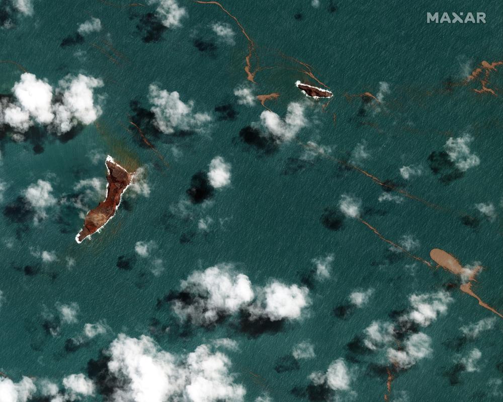 ?w=2048
Where do we send the bill?
Bill McKibben obviously at 360.org
Wow, there really is nothing CO2 can’t do!
The satellite images are awesome, look like a nuclear detonation from the ’50s ocean tests.
Yes, the numbers are not in yet but this will likely be much bigger than those.
Mt. St. Helens from space. Tonga appears to be much larger.
https://twitter.com/i/status/865193432771215360
Here in New Zealand, it was reported the ash cloud was covering an area with diameter from Hamilton the Christchurch. Thats 700km!
Philip, talking of numbers, the article says first:
…So it took about eight hours and 30 minutes to go about 5643 miles–thus a speed around 664 miles per hour…
But in the next passage we learn that:
…The water wave moves slower, around 400 mph…
If I read correctly, ccould you please explain what “it” in the first paragraph refers to?
Thanks in advance!
.-
Way way bigger
Maybe a hundred megatons. Fortunately most of the force went upward.
Yea, it definitely looked it. Gawd awful lot of energy released. And people think we can stop climate or anything else from doing what it does. Talk about hubris.
If this volcano produced CO2 then it must be man-made.
Here in New England, several “Raspberry Shake and Boom” devices heard the shock wave from the explosion. It was very windy when the sound came through and I’m completely amazed the signal was there to be found. These devices are as amazing as the event.
Image key:
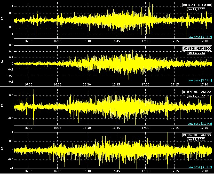
Sutton, NH (My RSB)
Weston Observatory, MA
Antrim, NH
Blue Hill Observatory, MA
By the way, these systems are Raspberry Pi based units with a geophone (Shake) and microbarometer (Boom). I bought mine for future work recording wind turbine infrasound, but both halves capture remarkable stuff. Mine just sits on the floor of my garage and amazes me every month.
Geoscientists are using them to get closeup looks at things like faults in Haiti (I saw the recent quake while it was happening) and rival research grade instruments.
[Commercial plug] See https://raspberryshake.org/
Ric – thanks for that info. Very interesting. I have used a few R-Pi’s, but mostly for computing/network related uses, plus one as a controller for a tracker for my camera to take astro photos.
This sounds like a very interesting use.
How incredibly cool; thanks for this info. I will look into setting one of these up.
I’m waiting for reports from folks that were around or even inside the blast area, It’s a big area, with I imagine people out on boats. I am hoping no one was killed, but it’s seems likely many were. Here is an Australian news report mostly about Tonga, with some spectacular ground level footage of the eruption. I hope the link works.
Tsunami hits Tonga after underwater volcano erupts (msn.com)
I wonder about some of the footage though – there appears to be an island under the erupting pyro cloud. Like maybe they stuck some stock footage into the report? It seems hard to get a line-of-sight superposition of an island this eruption
Ignore my earlier speculation about the footage, i was completely wrong. There “was” an island there before the start of the eruption and some way into it.
A recent eruption filled in between two of the islands, then a bunch of that eroded away, leaving a crater full of seawater, only slightly isolated from the open ocean. The current eruption is from the same area. Doesn’t look like anyone has imaging of what is there now.
Internet is down. It seems that the cable under the sea has been cut. Fiji’s cable is still O K , I gather. Ash in the sky makes contact with satellites difficult. From reports that got through ash is everywhere covering everything. This is a disaster of great magnitude. NZ will send a plane when flying conditions improve. It may already be on it’s way. It will survey from the air.
see Otago Daily Times. for uptodate reports.
Actually the Friday eruption collapsed the part that had formed between the islands. Still don’t know what the Saturday massive eruption did
Could the tsunami amplification at Monterey Bay be somehow related to the Monterey Canyon?
( Monterey Canyon – Wikipedia )
A bit of analysis since there seems to be very little coming out, data wise: See reference link
https://pubs.usgs.gov/pinatubo/lynch/
Comparison to Pinatubo; Biggest , most violent part of Pinatubo eruption resulted in maximum plume extent of 110,000 km^2 in 3 hours
My estimate was diameter of Hunga Tonga plume at 3 hours (from sat images ) was 250 mi , which would be ~ 127,000 km^2 … bigger than the biggest blast of Pinatubo
Thousands of tonnes of C02 from that Tonga eruption, I would wager.
I am interested to know how this Tonga eruption compares to the Santorini eruption in the Mediterranean of around 1600 BCE and to the Krakatoa eruption of 1883.
https://en.wikipedia.org/wiki/Minoan_eruption
https://en.wikipedia.org/wiki/1883_eruption_of_Krakatoa
I saw one estimate of VEI of 5
If look at the link your referenced for Krakatoa, a couple things are comparable:
1) The sound of the explosion was heard 2000-3000 miles away. On several YouTube videos, mostly showing the satellite presentation, commenters from as far away as the south island of NZ reported hearing Hunga Tonga the explosion
2) It is also noted the a pressure wave traveled the entire globe. In this post & comments specifically we have seen reports of the pressure wave being observed across North America & Europe. What would be interesting is if additional circlings of the globe of the pressure wave have been observed / recorded, similar to Krakatoa.
In short, with the limited data observations we have so far, there does seem to be support that this possibly might have been in the same range of size (ie VEI 6)
For reference and tying to my previous post, Pinatubo dropped global average temps by ~ 0.6 to 0.8° C & took 2-4 years to recover (depending on how you smooth / trend the data). See global temp ref page on this site and look at 1991. If the plume analysis of Hunga Tonga is indicative, this will be the ongoing story of effects on global temps
So more excuses for the CAGW crowd
That’s exactly my concern, now you will hear arguments that this buys us more time to implement draconian decarbonization…
Looks like we’ll ace the Paris (add on) target of 1.5°C.
(that’s if anyone ever believed in it, of course) 😉
Is this an undersea volcano, or is the summit above the water? I can’t tell from the photos I’ve seen.
It started as a summit above the water. The first blast removed the ash above the caldera so it flooded with seawater and was undersea. When the second blast occurred it would have been technically an undersea volcano.
That above water summits are just minor pimples on the edge of an undersea mountain with a caldera 20km across. This is likely where the major eruption came from , within the caldera. It seems that from historic Ash falls analysed on main island on Tongatapu 70 km away that are linked to this site indicate similar sized explosions around 800-1100 year periodicity.
https://theconversation.com/why-the-volcanic-eruption-in-tonga-was-so-violent-and-what-to-expect-next-175035