Reposted from Dr. Judith Curry’s Climate Etc.
Posted on May 12, 2021 by curryja |
by Alan Longhurst
“Never before in 1000 years the Atlantic Meridional Overturning Circulation (AMOC), also known as the Gulf Stream System, has been as weak as in the last decades“.
This announcement from the Potsdam Institute for Climate Impact Research was headlined recently in my morning newspaper in France (and in dozens of others elsewhere) as being the result of the anthropogenic ‘rechauffment climatique.’ We were warned that the consequences would include more rigorous winters for us over here in Europe.[1] Whoever wrote that cannot have critically examined the old adage that it is the Gulf Stream that brings Western Europe a comfortable maritime climate, because folklore it turns out to be…
Rahmstorf and his colleagues in Potsdam have hammered away at this issue for a long time now.[2] Their new paper is brief, presenting bundles of proxies intended to demonstrate that flow of the Gulf Stream has weakened in recent decades, and so put the equable maritime climate of Europe at risk.
But this a misleading oversimplification: in reality, the Gulf Stream is no more than a short segment of the wind-driven Subtropical Gyre of the North Atlantic and, as Wyville-Thompson wrote in 1871 concerning the Gulf Stream “after leaving the Strait of Florida…at about 42oN a large portion…turns eastward and southward and, eddying around the Sargasso Sea, fuses with the northern edge of the equatorial current and rejoins the main circulation.” [3]

So the North Atlantic Current which continues towards Europe and eventually enters the Arctic Ocean carries just a very small fraction of the water that had previously passed along the Florida coast as the Gulf Stream, together with slope and shelf water received from the seas around Newfoundland and the Gulf of Saint Lawrence.
Long-term change in SST is difficult to quantify, but the evolution of sea surface temperature indicated by the HadNMAT2 archive for the northern oceans is shown below.[4] Although the authors of this study suggest that these data support “existing estimates of global warming” it is difficult to imagine that they contain a progressive anthropogenic signal: the data are dominated (i) by the consequences of the numbers of ships at sea (ii) by the imprecision of the early bucket-over-the-side observations and (iii) by the advent of automated free-drifting instrumentation. These observations do not support the progression of the North Atlantic temperature/circulation indices that were offered by Potsdam to support their proposal for an exceptional slowdown in North Atlantic circulation during approximately the same period.[5]

And the pattern of SST changes on much smaller scale obtained by coastal sampling at lighthouses, tide gauge sites, and so on suggests that southeast coast of the US washed by the Gulf Stream has not, in fact, warmed progressively. Here are the data for three regions of the western Atlantic.[6] They do not support the trends indicated by Potsdam’s proxies over the last 150 years.

Such statements require evidence – in this case, not hard to find: the consequences of progressive adjusting, cleaning and homogenising of the original observations that previously had been shown as individually-coloured data plots at NASA Goddard were recently edited on their public website so that it became difficult to visualise any but the final homogenised data. Fortunately for us, they seem to have done the job by hand, and sloppily.
So I was able to find – and recover – their original plots for two stations very relevant to this discussion: Valentia Observatory on the shore of Galway and Vestmannaeyjar on an island south of Iceland. In each, the darker lines of the earlier year of the homogenised data have been shifted very significantly down to introduce significant warming where there was none in the lighter lines representing the unadjusted data. NOAA performs only a very modest adjustment of their GHCN-all data by warming just the final decade to produce their GHCN-M (adjusted) archive.

The pattern of the Galway data, having warmer periods around 1940 and also at the end of the century is repeated at rural stations in Western Europe; it also perfectly reflects the changing value of the NAO and the evolution of the atmospheric pressure field over the northeast Atlantic.


But warnings such as those from Potsdam have had a long history, despite rebuttal: the supposed effects on climate, especially of Europe, of a slowdown of North Atlantic deep convection were discussed in Nature in 2005 just prior to a post-Kyoto climate meeting, in relation to observations of deep flow at lower latitudes.[8] This notion was rapidly challenged by a comment from Carl Wunsch entitled ‘The Atlantic Conveyor may have slowed, but don’t panic yet!’ And it is not surprising that he should have reacted so dogmatically as he did: ‘European readers should be reassured that the Gulf Stream’s existence is a consequence of the large-scale wind system over the North Atlantic Ocean, and of the nature of fluid motion on a rotating planet. The only way to produce an ocean circulation without a Gulf Stream is either to turn off the wind system, or to stop the Earth’s rotation, or both.’[9]
Wunsch might well also have commented that the strongest heat flux from the Gulf Stream to the atmosphere occurs in the western ocean to the south of Nova Scotia, where sun-warmed water from low latitudes encounters very cold polar air. This process is dominated by latent heat of evaporation and is an anomaly of global scale – but along the coasts of western Europe there is little or no heat remaining in he ocean to transfer to the atmosphere.[10]

Consequently, it is clear that the popular image of a broad Gulf Stream sweeping eastwards across the Atlantic Ocean at about 45oN, bearing heat gained in the tropics to maintain Europe’s maritime climate, is unhelpful.
The fact is that everybody seems to have been forgotten that a perfectly good maritime climate exists at similar latitudes on the Pacific coast of North America – where there is no equivalent of the Gulf Stream: in fact, the cold water mass lying along this coast at about the same latitude as Europe, originates in the Gulf of Alaska and brings no warmth with it. But winters are warm and summers cool here, as Richard Seager, an apparently naive English oceanographer, discovered to his surprise when he first visited the US West coast. This maritime climate lacking a Gulf Stream analogue is the consequence of heat carried by south-westerly winds from the distant subtropical gyre across the cold coastal current.[11]
The warmth that these winds bring is not lost to the ocean in passing across the cold Alaskan coastal water, because sensible heat flux between ocean and atmosphere is almost everywhere a loss term. This is due to the micro-structure of the oceanic skin layer across which molecular diffusion dominates; only in high latitude autumn and winter, when strong wind-stress creates breaking waves which disrupt the molecular skin-layer, is there any significant flux of sensible heat from ocean to atmosphere. [12]
When these ‘anti-trade’ winds pass across the Rocky Mountains, their gyral structure is vertically compressed, expanding horizontally to preserve angular momentum. This forces the storm tracks to curve southwards across the continent so that they encounter the ocean again at a significantly lower latitude – in the northern Caribbean and east of Florida, where sensible heat is transferred to the chilly atmosphere very rapidly. Then, during its north-easterly movement across the Atlantic towards Europe, the surface air mass picks up further heat from the surface of the ocean by sensible heat flux and carries it at a rate that significantly exceeds that carried in the ocean.[13] If these winds crossed the ocean to Europe at the same latitude as they encountered the western Rocky mountains, their consequence for European climate would be much less positive.
These images from Ventusky simulations for (left) air temperature close to the surface on 30 November 2011 and (right) for 31 July 2020. are chosen to show the classical softening of the western European winter climate by warm south-westerly winds (left) and also a very different situation, not often talked about in relation to European climate, concerning our very uncomfortable southern neighbours, North Africa and the Sahara desert.

Such conditions can develop also in winter as they did on 6 February this year when my car, and all the others in town, was speckled with raisin-sized blobs of damp Saharan mud aggregated from dust particles carried in (and fallen from) a low cumulus deck.[14]
So the myth of the maritime, equable climate brought to Europe by the Gulf Stream really needs to be seen for what it is – a myth. It is perhaps appropriate to the British Isles and Scandinavia, but certainly not to the sub-continent as a whole. And, that “Gulf Stream at its lowest in 1000 years” of Potsdam that was trumpeted by a scare-hungry press is perhaps also mythical – but is certainly unhelpful in understanding how the real world actually works.
But I fear that we shall hear more, and probably much more, from the Potsdam Institute for Climate Impact Research as a result of their espousal of a failing Gulf Stream and a chilling Europe – a concept that doesn’t bear close examination: they are, after all, funded to study the fields of “global change, climate impacts, and sustainable development” and I infer from their writings that this is not interpreted as a mandate to try to understand the natural world – and so sometimes, as in this present case, they get it wrong.
Alan Longhurst
Place de l’Eglise
46160 Cajarc, France
[1]Caesar, L e al.; (2021) . Nature Geoscience, 14, 118-120. 10.1038/s41561-021-00699-z.
[2]Rahmstorf, S. et al. (2015) Nature Climate Change 5, 475-480, DOI.10.1038NCLIM2554
[3]Nature (1871) vol. 4, 251-253. Image from Tomczac and Godfrey’s indispensible “Regional Oceanography” of 2002, freely available on-line.
[4] Kent, E.C. et al. (2013)J. Geophys. Res. 118, 1281-1298.
[5]Rahmstorf, S. et al. (2015) Nat. Clim. Change 6, DOE. 10.1038/NCLIMATE2554
[6] from Shearman, R.K. and S.J. Lutz (2010) J. Phys. Oceanogr. 40, 1004-1017
[7]Neto, A.G. et al. (2021) Communications Earth Envir.| https://doi.org/10.1038/s43247-021-00143-
[8] Bryden, H.L. et al. (2005) Nature, 438, 655-657.
[9] Wuntsch, C. (2004) Nature, 428, 601.
[10] Broecker, W.S. (1991) Oceanography 4, 79-89; images, left – Tomczac and Godfrey again and, right, from Bedford Inst. Oceanogr. Rev. 1984.
[11]Seager, R. et al. (2002) Quart. Roy. J. Meteor. Soc. 128, 2563-2586.
[12]images from Seager, R. (2006) Am. Scient. 94, 334341 and from Tomczak (2003). Annual mean ocean-to-atmosphere heat flux (W.m2)
[13]Seager, R. et al. (2002) Quat. J. Roy. Met. Soc. 128, 2563 doi.10.1256/qj.01.128
[14]Cuadros, J. et al. (2015) Atmosph. Envir. 120, 160-172
It’s another good example of the problems at the root of popular climate alarmism.
Like the Arctic permafrost-methane time-bomb, the collapse of the Gulf Stream current(s) has now been dismissed by the ‘leaders’.
But having once raised the idea in the pursuit of sensationalism, they now find it almost impossible to get the troops to stop talking about it.
Could be a handy “get out” clause for the AGW Aristocracy if warming (or lack of it) particularly in Europe, doesn’t go according to modelled projections……!!
Latitude of London, United Kingdom: 51.50853
Climate and weather averages from Timeanddate.com:
Similar latitudes.
Similar locations on the Eastern edge of a ocean, not too far from the ocean.
Similar weather.
Where’s the big warm current bringing warm pleasant weather to the West coast of North America?
Swimming in the waters off the coast of California is chilly!
Nothing to do with the Gulf Stream current. It is all about the huge ocean moderating the weather downwind.
Unlike the East coast of North America where eddies of the Gulf Stream frequently swirl inshore yet rarely affect weather inland.
Well, since you ask, there is the Kuroshio, but it is much farther away.
https://th.bing.com/th/id/OIP.oDyZIs2JXAC3QMblPT7BrwHaFa?pid=ImgDet&rs=1
Of course anytime a large body of water is upwind, temperatures will be far more moderate than when winds are sweeping down from continental polar regions for much of the year.
In the low Sun season, the land modifies cold air only very gradually. Water does so much more quickly. And the Pacific ocean is far larger, so air masses travelling over it and impacting the West coast of North America have far longer to modify.
Just look at this gif of SST, which shows a plume of similar temp water to the Gulf Stream, that originates with the Kuroshio in the Pacific, and extends all the way to North America.
They are even at similar latitudes, although it appears the Gulf Stream has a somewhat larger influence at a higher latitude. For one thing, it is gonna be less diluted than the Kuroshio:
Just looking at some maps, we can see there are many factors leading to the discrepancy between, for example, Europe and North America at similar latitudes. And there is a big difference, as seen in a global view of average annual temp:
We could also look at the Koppen Climate map of the world:
http://i0.wp.com/www.ruthlessreviews.com/wp-content/uploads/2015/02/koppen-climate-map.jpg
And see that the bulk of Europe has a far milder climate than the bulk of the Western North America, particularly when similar latitudes are compared.
But, as I was saying, there are many geographical differences.
For one thing, North America has several very large North to south oriented mountain ranges on it’s western side, while Europe has the Alps, which are further inland, oriented mainly east to west rather than north south, and do not extend westward all the way to the Atlantic coast. So western Europe has the Mediterranean just to the south, and the Hot Sahara Desert south of that.
So many very big differences.
But also some similarities.
Er, sediment studies of the seafloor under the Gulf Stream as it goes around the Florida peninsula indicate that the Gulf Stream speeds up when warm and slows when cold. It’s called viscosity and density. Cold makes for more viscous and dense water and a slower flow. Not rocket science.
In the several minutes of your life you have spent studying these issues, has it ever occurred to you to wonder about which is the cause and which is the effect?
Besides for that, has anyone ever published any studies that were complete bullshit, or misrepresented a study in an online comment?
Not that anyone ought to be quick to question someone who begins sentences with the word “Er”.
quote
Consequently, it is clear that the popular image of a broad Gulf Stream sweeping eastwards across the Atlantic Ocean at about 45oN, bearing heat gained in the tropics to maintain Europe’s maritime climate, is unhelpful.
The fact is that everybody seems to have been forgotten that a perfectly good maritime climate exists at similar latitudes on the Pacific coast of North America
unquote
This is a big geography fail.
Take the U.K. – this is not equivalent in latitude to the USA. Not to San Francisco or even Vancouver but quite a lot further north. Britain’s latitude extent between 50 and 60 north makes it level with much colder (in winter) coastal British Columbia on the west side and northeastern Quebec on the east coast. It’s even level with the southern tip of Hudson Bay. Moving to the east Eurasian coast, we’re talking about the Kamchatka peninsula and very cold Siberian latitudes. The Shetlands are even on a latitude with Magadan. All these places, while also coastal, are quite a lot colder than Britain in winter. The traditional attribution of this to the “Gulf Stream” is correct.
The Gulf Stream and AMOC are a consequence of the current continental layout of the earth, in particular the unusual presence of a meridionally bounded ocean – the Atlantic. Bounded by land to the east and west almost from pole to pole. This forces ocean currents into a lot of north-south movement. This cases the AMOC and the related phenomenon of heat piracy across the equator stealing heat from SH to NH.
From the article: “The pattern of the Galway data, having warmer periods around 1940 and also at the end of the century is repeated at rural stations in Western Europe”
This pattern is repeated all over the world.
It was just as warm in the Early Twentieth Century as it is today. All the unmodified temperature charts show this. This means the Earth is not experiencing unprecedented warming today and CO2 is not the control knob of the Earth’s climate.
They only thing that does not show this pattern is the bogus, bastardized, computer-generated Hockey Stick charts.
The bogus, bastadized Hockey Stick chart is the only thing that shows any warming. And it’s all a BIG, computer-generated, LIE.
Just a question, about where hurricanes go: does this Atlantic swoosh account for why hurricanes go up the North American east coast and if they last long enough, cross the northern Atlantic and go south along the western coast of the Euro continent and the UK?
Just askin’, because some time back (1990s, I think), there was one hurricane after another on the East Coast and they all followed that path: up the coast, across the northern end of the Atlantic, and then head southeast toward the UK and Europe. There was a satellite shot of that bunch of storms. Don’t remember the exact year, but I was still living in Chicago and it showed up on the weather map as a satellite shot.
Atlantic Swoosh?
Hurricanes are steered by wind currents in the middle and upper atmosphere.
Sometimes these steering currents are strong and stable, and other times they are absent or intermittent.
They are usually highly changeable, since the nature of hurricanes is such that any significant wind shear, or change in wind speed and direction with height, can tear them apart in a matter of hours. The stronger one’s tend to become somewhat more resistant to wind shearing, but only somewhat.
Since hurricanes form within one air mass by definition, and in the Atlantic this air mass is mostly in the area of the Easterly trade winds, they often move from East to West.
They are pushed by the winds that comprise the southern part of what is often called the Bermuda High, which somewhere between Florida and Texas curves to a more northerly direction.
In the fall, cold fronts moving into the southern US often pick up these storms and move them rapidly northward.
In other situations, the nose of the High only extends as far as the Eastern Atlantic ocean, and so the storms turn and move up the coast, pushed by the same high pressure cell as had been pushing them westward.
At higher latitudes, westerly winds often prevail, an d in fact are called the prevailing westerlies.
So a common path for such storms is east, then north, and then west.
A look at the path of all tropical storms on one map, gives a good idea of the average direction of steering currents in the atmosphere:
http://www.physicalgeography.net/fundamentals/images/tropical_cyclone_map_lrg.gif
Weak Bermuda High:
Stronger Bermuda High:
http://static-24.sinclairstoryline.com/resources/media/efe46f01-aba2-45e5-8772-4d1844ccea6f-large16x9_SeptemberBermudaHigh.png?1530302368159
“Strongest” Bermuda High: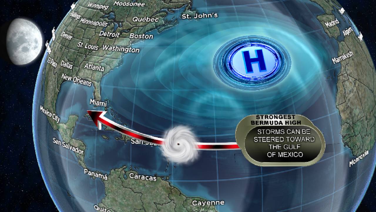
Dorian-steering-currents.png (1024×696) (arstechnica.net)
Thanks for that, Nicholas.
In 2004, the winds aimed a lot of them at Florida…right at my house!
Then the winds changed, and they all missed. Kind of.
Lost power for weeks on two separate occasions that year.
Nothing worse.
http://2.bp.blogspot.com/-PK4xhARXJS8/T8pezwedglI/AAAAAAAAJ1M/XqFQ_oMLIVQ/s1600/2004+Hurricane+Season.jpg
Hmm, that image did not convert. Try this way:
“is almost everywhere a loss term”
You couldn’t write a more confusing sentence if you tried to.