
Tom Corringham, University of California San Diego
Ask people to name the world’s largest river, and most will probably guess that it’s the Amazon, the Nile or the Mississippi. In fact, some of Earth’s largest rivers are in the sky – and they can produce powerful storms, like the one now soaking California.
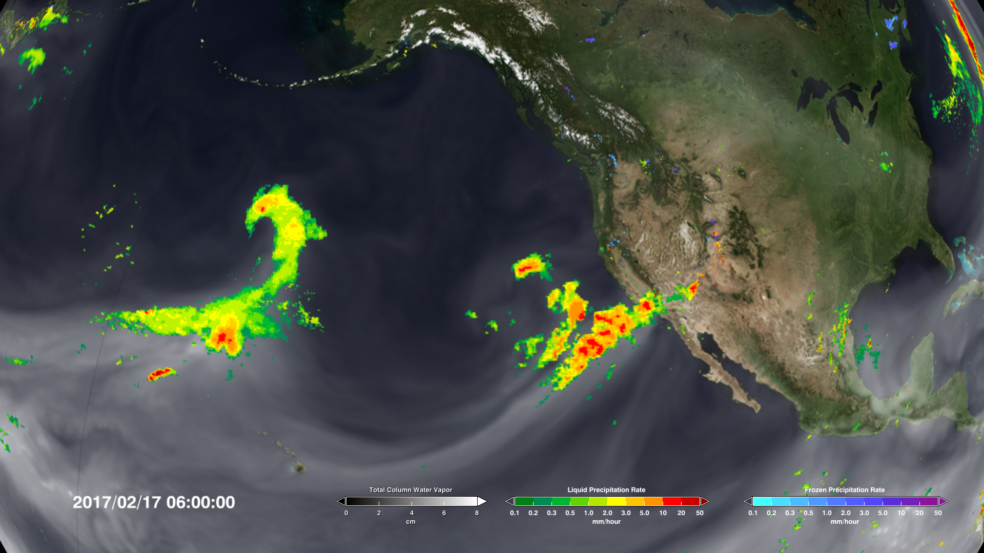
Atmospheric rivers are long, narrow bands of moisture in the atmosphere that extend from the tropics to higher latitudes. These rivers in the sky can transport 15 times the volume of the Mississippi River. When that moisture reaches the coast and moves inland, it rises over the mountains, generating rain and snowfall and sometimes causing extreme flooding.

In the past 20 years, as observation networks have improved, scientists have learned more about these important weather phenomena. Atmospheric rivers occur globally, affecting the west coasts of the world’s major land masses, including Portugal, Western Europe, Chile and South Africa. So-called “Pineapple Express” storms that carry moisture from Hawaii to the U.S. West Coast are just one of their many flavors.
My research combines economics and atmospheric science to measure damage from severe weather events. Recently I led a team of researchers from Scripps Institution of Oceanography and the Army Corps of Engineers in the first systematic analysis of damages from atmospheric rivers due to extreme flooding. We found that while many of these events are benign, the largest of them cause most of the flooding damage in the western U.S. And atmospheric rivers are predicted to grow longer, wetter and wider in a warming climate.
Rivers in the sky
On Feb. 27, 2019, an atmospheric river propelled a plume of water vapor 350 miles wide and 1,600 miles long through the sky from the tropical North Pacific Ocean to the coast of Northern California.
Just north of San Francisco Bay, in Sonoma County’s famed wine country, the storm dumped over 21 inches of rain. The Russian River crested at 45.4 feet – 13.4 feet above flood stage.
For the fifth time in four decades, the town of Guerneville was submerged under the murky brown floodwaters of the lower Russian River. Damages in Sonoma County alone were estimated at over US$100 million.
Events like these have drawn attention in recent years, but atmospheric rivers are not new. They have meandered through the sky for millions of years, transporting water vapor from the equator toward the poles.
In the 1960s meteorologists coined the phrase “Pineapple Express” to describe storm tracks that originated near Hawaii and carried warm water vapor to the coast of North America. By the late 1990s atmospheric scientists had found that over 90% of the world’s moisture from the tropics and subtropics was transported to higher latitudes by similar systems, which they named “atmospheric rivers.”
In dry conditions, atmospheric rivers can replenish water supplies and quench dangerous wildfires. In wet conditions, they can cause damaging floods and debris flows, wreaking havoc on local economies.

Helpful and harmful
Researchers have known for some time that flooding due to atmospheric rivers could cost a lot of money, but until our study no one had quantified these damages. We used a catalog of atmospheric river events compiled by Scripps Institution of Oceanography’s Center for Western Weather and Water Extremes, and matched it to 40 years of flood insurance records and 20 years of National Weather Service damage estimates.
We found that atmospheric rivers caused an average of $1.1 billion in flood damages yearly in the western U.S. More than 80% of all flooding damages in the West in the years we studied were associated with atmospheric rivers. In some areas, such as coastal northern California, these systems caused over 99% of damages.
Our data showed that in an average year, about 40 atmospheric rivers made landfall along the Pacific coast somewhere between Baja California and British Columbia. Most of these events were benign: About half caused no insured losses, and these storms replenished the region’s water supply.
But there were a number of exceptions. We used a recently developed atmospheric river classification scale that ranks the storms from 1 to 5, similar to systems for categorizing hurricanes and tornadoes. There was a clear link between these categories and observed damages.
“
Atmospheric River category 1 (AR1) and AR2 storms caused estimated damages under $1 million. AR4 and AR5 storms caused median damages in the 10s and 100s of millions of dollars respectively. The most damaging AR4s and AR5s generated impacts of over $1 billion per storm. These billion-dollar storms occurred every three to four years.
A moister atmosphere means worse storms
Our most significant finding was an exponential relationship between the intensity of atmospheric rivers and the flood damages they caused. Each increase in the scale from 1 to 5 was associated with a 10-fold increase in damages.
Several recent studies have modeled how atmospheric rivers will change in the coming decades. The mechanism is simple: Greenhouse gases trap heat in the atmosphere, warming the planet. This causes more water to evaporate from oceans and lakes, and increased moisture in the air makes storm systems grow stronger.
Like hurricanes, atmospheric rivers are projected to grow longer, wider and wetter in a warming climate. Our finding that damages increase exponentially with intensity suggests that even modest increases in atmospheric river intensity could lead to significantly larger economic impacts. https://www.youtube.com/embed/X3cP4egWRbk?wmode=transparent&start=0 Scientists have developed a scale for categorizing atmospheric rivers that reflect both their replenishing capacities and their dangerous effects.
Better forecasting is critical
I believe that improving atmospheric forecasting systems should be a priority for adapting to a changing climate. Better understanding of atmospheric rivers’ intensity, duration and landfall locations can provide valuable information to residents and emergency responders.
It also is important to discourage new construction in high-risk areas and help people move to safer locations after major disasters, rather than rebuilding in place.
Finally, our study underlines the need to reduce global greenhouse gas emissions. These storms will keep coming, and they’re getting stronger. In my view, stabilizing the global climate system is the only long-term way to minimize economic damage and risk to vulnerable communities.
[ Deep knowledge, daily. Sign up for The Conversation’s newsletter. ]
Tom Corringham, Postdoctoral Scholar in Climate, Atmospheric Science and Physical Oceanography, University of California San Diego
This article is republished from The Conversation under a Creative Commons license. Read the original article.
I might have missed it, but where is his evidence that any of this is any worse than before?
Any definition of “worse” that relies on the amount of property damage is not based on the objective severity of weather phenomenon.
I often have a difficulty with rating some articles: 5 stars for showing them, but 0 stars for the contents. Is that a 2?
More manure from The Miserable Conversation. The greatest AR which hit the US West Coast in my 70 years of life struck in the winter of 1964/65. The second strongest AR was probably a tie between 1955/56 and 1996/97. The greatest known West Coast AR of all time was in the winter of 1862/63. The very strong AR of 2016/17 was powerful, but it was more localized than any of the other above examples.
I find it hard to comprehend how these supposed scientists can be so blind to reality, and so arrogant to think that they are superior minds.
Until Atlantic Americans arrived in California and began building levees and later, dams, for much of the year Native Americans crossed California’s Great Central Valley by canoe.
History, it’s more than just dusty old unread books written by dead white men.™ More people should read those books and learn some history.
P.S. Why do feminists consider the word ‘history’ sexist but not the word ‘<u>her</u?itage’? I’m asking for a buddy taking a Grievance Studies course at a California state university.
Until Atlantic Americans arrived in California and began building levees and later, dams, for much of the year Native Americans crossed California’s Great Central Valley by canoe.
History, it’s more than just dusty old unread books written by dead white men.™ More people should read those books and learn some history.
P.S. Why do feminists consider the word ‘history’ sexist but not the word ‘<u>her</u>itage’? I’m asking for a buddy taking a Grievance Studies course at a California state university.
Until Atlantic Americans arrived in California and began building levees and later, dams, for much of the year Native Americans crossed California’s Great Central Valley by canoe.
History, it’s more than just dusty old unread books written by dead white men.™ More people should read those books and learn some history.
P.S. Why do feminists consider the word ‘history’ sexist but not the word ‘HERitage’? I’m asking for a buddy taking a Grievance Studies course at a California state university.
The age of current events climatology is upon us.
The definition of the word “river” is seriously being mauled. If any flow of water by some physical process within the fluids that govern the Earth’s climate can be called rivers, then probably the Western Atlantic Gulf Stream is the largest river in the world. But I do not hold by such tripe. The Gulf Stream is NOT a river, it is an ocean current. So-called atmospheric rivers are not rivers in the same sense as surface rivers, because they have no stream beds, no flood plains, no alluvial fans when the hit the boundary of land to ocean. What they are is a phenomenon not well understood until very recently, when satellite weather tracking showed us their extent and power. And just like the horrid example of the so-called “ozone hole” over the Antarctic continent, which was turned into a human caused disaster almost from it’s very inception (which was not when Dobson measured low ozone levels from the beginning of his experiments on that continent in the 1950s, but rather when the first remote sensing missions looked down upon it from space in the early 1970s), we simply do not have enough history with so-called atmospheric rivers to say we know “JACK SQUAT” about whether they are increasing, decreasing, trending this way or that, or about what the significance of any trends might really mean in the long run. Did so-called atmospheric rivers push huge amounts of water onto the land during periods of glaciation? I would bet they did. How could those glaciers form and carve out the valleys that we see today that are U-shaped, but have no glacier in them, anymore, one of which is Puget Sound? How could water have filled the Great Basin to overflowing in Lake Bonneville (now a tiny little endorheic runt called Great Salt Lake). What water source filled Lake Missoula and carved the Columbia and Snake River gorges with great floods we could not even imagine until recently. How could almost the entire area of what is now Canada and the northern states of the USA been covered in a mile or two of ice? Seriously, was there no atmospheric river involved? Was that just a friendly little atmospheric babbling brook, before human CO2 began to turn it into a raging monster? This idiocy must stop!
Ps. For the best use of the phrase “we don’t know JACK SQUAT” refer to climate gate e-mail from Ed Cook. Oh, wait, he used another term. My favorite use of the term in all of human history is Chris Farley as motivational speaker Matt Foley on an SNL sketch. If only I could figure out a way to defund climate alarmists, and see them all living in a van down by the river, eating a steady diet of government cheese. https://www.youtube.com/watch?v=Xv2VIEY9-A8
Courtesy, Merriam Webster:
Your personal opinion regarding the definition of “river” is narrow, Mickey Reno.
But Jerry Brown was too focused on Antarctic ice to worry about his home state. Money does that to politicians.
Er…
I don’t thing the word “focused” belongs in the same sentence as “Jerry Brown”.
Hmmm. “By the late 1990s atmospheric scientists had found that over 90% of the world’s moisture from the tropics and subtropics was transported to higher latitudes by similar systems, “
Sounds like evaporating moisture in the tropics (absorbs heat) moves to cooler areas and drops (condenses and gives up heat). Who would have thunk it? Heat moves from warm to cool areas? Perish the thought.
Dr. Corringham reports that higher surface temperature makes for more evaporation and more water vapor in the atmosphere leading to stronger storms. That has a right kind of feel to it but If so, then atmospheric humidity, relative and specific, and total column water vapor must be increasing for the past many decades. These kinds of parameters are routinely measured and the measured data by NOAA does not agree.
NOAA says that relative atmospheric humidity has going down at all altitudes measured including near the surface (1,000 mb) since 1948. Specific humidity has also been going down at altitude, while near the surface it’s up a wee bit. Also, total column water vapor has declined or remained unchanged since 1983. See for yourself at climate4you.com under the climate+clouds button.
I find it curious that Dr. Corringham would not consider readily available atmospheric water vapor data before making his alarming conclusions. It is equally curious that he apparently did not consider economic development in the affected areas before concluding that increasing damage is caused by worsening storms. Perhaps Roger Pielke needs to review the paper?
According to the data provided by the alarmists, the oceans have warmed by about .06C. I wonder how much extra evaporation that would cause?
Beyond that, evaporation of water takes energy. If there is a huge increase in evaporation as the alarmists claim, this means that there has been a huge cooling in the tropics. Evaporation is a large negative feedback that none of the models take account of.
I do not have much knowledge of what the world’s climate models do or don’t consider. If you have such information, please post it here. Removal of heat from the surface of the earth by evaporation must be a major heats-loss mechanism. Willis Eschenbach has written about it on several occasions. It certainly is apparent on my sweaty summer forehead. The now wetter warm air rises (warm humid air is lighter than warm less-humid air), forms clouds at some altitude releasing the heat of evaporation with half going up and mostly out to space and half going down. Perhaps models try to parameterize this process because it occurs over much smaller areas than the areas considered by models. If they do not consider it at all, it seems to me that that is a major perhaps fatal failing.
Under the topic of helpful and harmful they mention only harmful. It seems to me that the nutrients sent to the sea in floods help fertilize the ocean, and also help move organic and inorganic carbon to direct and rapid burial — i.e. a carbon sequestration method.
If one wishes to avoid most of the harm, stop subsidizing building in flood plains.
Very sensible discussion up to the point where the word prediction is introduced. Once we get to projecting what atmospheric rivers will do in a slightly warmer world, we begin gazing into a totally unreliable crystal ball. We move from objective evidence to conjecture based on only a scanty few known facts and a whole lot of assumptions.
I grew up in the Bay Area and I remember Guerneville flooding all the time and I wondered why anyone would build a house there. Still people have homes there right on the river. I don’t know the impact, but there’s been a lot of paving over of Ca in the last 50 years. It has to increase the danger of flooding.
Is it even conclusive that atmospheric moisture has trended upward? Never mind AGW.
I just want an honest science answer to the moisture question.
When I google images – “atmospheric moisture trend” I get a whole lot of contradiction like this.
It was just a few years ago that the California drought was permanent because of global warming.
Yes, its ‘Brown California’ as Mann says so, he claims its not just ‘dry’ but ‘hot’ as well which together spell ‘doom’
https://www.pnas.org/content/112/13/3858
In December of 1964, when college Christmas Break started, it started raining in Northern California. My recollection is that it rained non-stop for about 2 weeks. Just before Christmas, the rock-fill Hell Hole dam under construction on the Rubicon river failed, and the reservoir water poured into the Middle-Fork of the American River, taking out something like 13 suspension bridges on the way down; the first bridge to survive the wave of water was the railroad bridge just outside of Auburn. Catastrophic floods in California are not a new phenomena.
The 1964 flooding wasn’t confined to California:
https://en.wikipedia.org/wiki/Christmas_flood_of_1964
That flood struck the entire coast all the way up into Canada. I took a Greyhound bus ride from SF to Seattle in the summer of 1965 to stay with my cousins. I had never seen such extensive damage in my life. What was supposed to be an 18 hour bus ride ended up taking 38 hours because of all of the many road detours. There were improvised bridges over streams in places, washed out roads everywhere, and people working at straightening all of this mess out all the way along the trip.
It was estimated that around 4,000 vehicles were swept down the length of the Klamath river and out into the ocean. Every bridge across the mighty Klamath river went down with the exception of the bridge at the ancient Indian town of Weitchpec. That bridge crosses a deep gorge over the Klamath right above where the Trinity river joins the Klamath. The bridge sits high above the river, maybe close to two hundred feet. When I was living there in the 1970s you could still see tree branches stuck in the girders of the bridge. That was why this bridge survived, but only barely. When you stand on that bridge and look to the west at the wide junction where the two rivers joined it is almost incomprehensible to imagine that vast area filled with raging mud filled water. An interesting note to this area is that the old ancient town of Weitchpec which sat on a bar just to the south of this bridge was estimated to be around 15,000 years old. The 1964 flood wiped out that ancient site, and left only a long sand/gravel bar in its wake.
Thanks for that
https://en.wikipedia.org/wiki/Christmas_flood_of_1964
‘California Governor Pat Brown was quoted as saying that a flood of similar proportions could “happen only once in 1,000 years,”
That flood was probably very close to the level of rain which struck during the Ark Storm of 1862/62. The saving grace for the Sacramento Valley was that the dam on the Feather River at Oroville had just been completed, and was ready to be filled in the winter of 1964/65. It was estimated that the dam would be filled by the end of the 1960s. However, the huge rains in that winter filled the dam in one fell swoop. That saved the upper Sacramento Valley and all the way down the Sacramento river from being completely inundated.
Yes, the Summer of ’65 was a difficult time to get around in Trinity Co because of all the temporary bridges.
But the so called greenhouse gases do not trap heat energy. Good absorbers are also good radiators. What ever LWIR photons they absorb they quickly radiate away for a net heat energy gain of zero. The greenhouse gas molecules also sharre heat energy with surrounding gas molecules just like all molecules in our atmosphere. If any molecules are heat trapping it would be the non-greenhouse gas molecules because they are such poor radiators to space.
It is my experiencing from living on the cost of California for more than 60 years, storms decades ago seem to have been a lot worse than the storms we have had this year.
There is one other factor of great interest to consider when talking about West Coast flood patterns. Note how close to the solar minimum these largest storms are. The 1964/65 major flood which inundated everything from Marin county north to the Canadian border struck right at the solar minimum as did the major ARs of 1955/56 and 1996/97. The localized large AR in 2016/17 occurs right as this last solar minimum begins, note that sunspots zeroed out right at the very end of Dec 2016.
There is a statue of the Donner Party at that lake which represents the depth of the snow which trapped them. I was living at Lake Tahoe in the winter of 1970/71. The snow that year equaled the depth of the snow that the Donner Party encountered as it rose to the exact same height as the memorial statue at Donner Lake. There was an amazing 12 feet in 3 days in late December after many earlier strong snow storms, and then around 10 days later we were hit with 6 feet in one day. I finally dug my car out of the snow in late April 1971.The odd thing about this is that there are no records of this huge storm. They have been lost to time for some reason.
There is a possible correlation between that snow in 1970/71 and the Donner Party tragedy in that sunspots were at low levels. The Ark Storm of 1862/63 is also similarly situated, striking not long after a rapid drop from the max of that cycle.
Everyone fails to realize that after 4 billion years the climate was perfect in 1950. March, actually. March, 1950. Yup, we had it and blew it.
“Like hurricanes, atmospheric rivers are projected to grow longer, wider and wetter in a warming climate”. Except that they haven’t. I don’t know about you, but I’m really getting tired of this alarmist BS. It seems to never end and to be getting more desperate.
Seems there’s some confusion about atmospheric greenhouse rivers.
Warm brown greenhouse pissing https://youtu.be/QkuSKTcxDfk
related: Jobs in greenhouses https://www.google.com/search?q=greenhouse+workers+in+poland&oq=greenhouse+workers%7C&aqs=chrome.
https://www.google.com/search?client=ms-android-huawei&sxsrf=ALeKk01fzu-TCKJT0qlnxjAfyRbAmOiRLA%3A1613193985779&ei=AWMnYJ6CL5L4gQb9uYuIAQ&q=greenhouse+workers&oq=greenhouse+workers&gs_lcp=ChNtb2JpbGUtZ3dzLXdpei1zZXJwEAMyBAgjECcyBAgjECcyBAgjECcyAggAMgIIADICCAAyBggAEBYQHjIGCAAQFhAeUI6EAliBigJgkLMCaABwAHgAgAGQAYgBowOSAQMwLjOYAQCgAQHAAQE&sclient=mobile-gws-wiz-serp
Anyway, ~cr : rule of thumb:
CO₂ lags temperature –
– First heat the Greenhouse, add CO₂
– Then plants grow !