Joe Bastardi · Jul. 11, 2019

On Tuesday, Weatherbell.com started covering the threat of flooding in New Orleans, and it’s a very real threat. But a storm like Barry, assuming it makes landfall as far west as we think it will, would not contain the same kind of threat if not for some preexisting conditions that occurred in the winter and spring.
Back on April 23, I warned about how tropical cyclones would be used as ammo in the weaponization of the weather. That forecast is already coming true with today’s threat.
First of all, we identified this threat last week. I’ve been very noisy about it because it is emblematic of the kind of season we have predicted, with scattershot in-close development and likely below-average activity in the main development regions of the Atlantic. So there’s nothing magical or mysterious about this storm developing from a feature that originated well away from the deep tropics.
In fact, I talked about this on Neil Cavuto’s show last week. A notorious example was Alicia in 1983, which developed south of Louisiana from a feature that originated from the north. The storm went on to hit as a Category 3 hurricane southwest of Galveston, TX. So the idea that this week’s storm should intensify quite rapidly before reaching the coast has been discussed since last week.
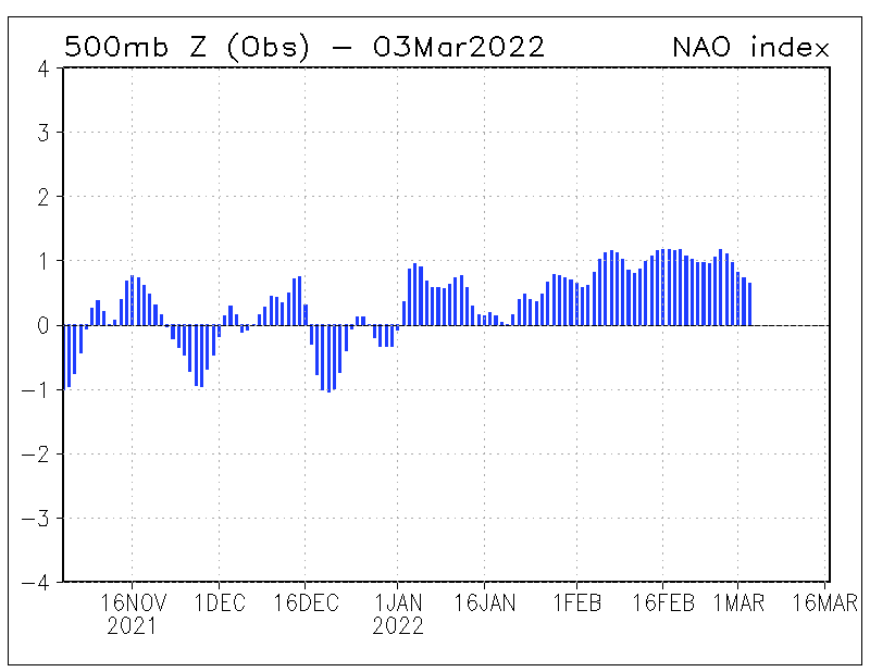
But what makes this storm so different and so threatening to New Orleans is how high the Mississippi River is. The reason it is so high is because of the late, cold winter in the Great Plains. Prodigious snowfall resulted in enhanced snowmelt, which was followed by above-normal rainfall.
What is particularly galling is that around the turn of the century, there was hysteria about snow being a thing of the past. Yet snow is increasing in the Northern Hemisphere! Then, back in 2013, after the hot summers of 2010-12 were blamed on climate change (even though the heat and drought were similar to 1952-1954 and could not hold a candle to the 1930s), there were predictions that a new dust bowl would develop due to climate change. I publicly challenged that notion in 2013 on several outlets. Here we are several years later and the question is: How can you blame “man-made climate change” when the result was exactly opposite of what was being predicted?
I fully expect warmists to go full bonkers over this storm (a weather event), because it part of their recent behavior of crying over every storm (a weather event) that brews up, then say climate change caused it.
Now every stormy weather event is caused by climate change…….
They have reached the bottom after 30 years of going from 30 years makes a climate trend, to just a single day makes a climate change.
You Colonists know nothing about Climate & Weather! The BBC Whether (mispelling deliberate) Soothsayers have just commented that “THEY” are keeping an eye on Tropical Storm Barry, & “THEY” will keep us posted on whether it becomes a hurricane (they wish) or not as it approaches land! Apparently the Mississippi River is running higher than it “should” be, whatever that actually means! I live just outside Exeter, (South West UK) have done for 30 years, & weirdly, every time there is heavy rainfall, the River Exe runs much higher than “normal”, when they open up all the flood control measures upstream toreduce the chances of heavy flooding! FYI, the River Exe, like many rivers & river systems in the UK, regularly flooded local areas during heavy rainfall patterns, seasonal or otherwise. The great River Thames was a classic, that’s why the guvment of the day spent millions of £s over many years (50s, 60s, 70s) building flood defences to prevent these oft predicted “weather” events! Sarc off! 😉 I wish all those living in flood risk areas of the Mississippi well & safety!
As Levi Cowan has pointed out in his latest forecast video the question of if Barry becomes a hurricane or not is academic and has little bearing on the effects because at best it will be a CAT I and it’s winds are already showing hurricane force gusts. So really the BBC is just wishing for a chance for better propaganda.
https://www.tropicaltidbits.com/blog/?s=2019
It looks like the center is already over land and according to Earth.Nullschool the current highest winds are 57 mph
https://earth.nullschool.net/#current/wind/surface/level/orthographic=-88.33,27.66,3000/loc=-90.955,28.972
OH, the BBC got their undies in a bunch when the Mississippi River froze in January of 1976. I was over there in London, and the tugs stuck in the ice on Ole Miss were all they could talk about, e.g., “How is this POSSIBLE?????” But they made no references at all to those Frost Fairs on the Thames prior to the existences of the reporters who were reporting.
If there is snow in April where I live, is it a fluke or a long-term trend? If I record it with photos, which the camera’s software date stamps, then it’s easy enough to check on what’s happened prior to the current late cold weather.
If something happens once, it’s weather, If it happens every year for 20 years, then it may be a trend toward a new direction, and I use MAY instead of IS, because it could end abruptly.
Hysterics have no place at all in any of this, but how do you stop the hysterics from rising in volume, other than by recorded facts?
To argue against the effects of climate change by use of fossil fuels is destructive in itself. We are all very well aware of mans impacts in the quality of life in every habitat worldwide since the industrial revolution began. Its like we wanna say that we have helped our climate by our actions instead of taking responsibility of the truth. We dont need more effecient light bulbs, we need to turn them off.
No one is stopping you from showing us the way. Turn your bulbs off.
“then say climate change caused it.”
No one says that.
Loydo July 13, 2019 at 12:26 am
“then say climate change caused it.”
No one says that.
If you do a Google news search on “Climate Change Barry” Here’s what you get:
Storm Barry’s threat to New Orleans heightened by climate change
Aljazeera.com-11 hours ago
While no single storm can be linked directly to climate change, the trend of warming air and seas around the globe has caused conditions that …
Tropical Storm Barry Could Hit the Gulf Coast With ‘Unprecedented …
TIME-Jul 11, 2019
Is Climate Change Loading Tropical Storm Barry Up With Extra Rain?
Reason-10 hours ago
Tropical Storm Barry is part of an alarming trend driven by climate …
ThinkProgress-16 hours ago
Why Barry is such a scary storm
Opinion-CNN-9 hours ago
Climate Change Fills Storms With More Rain, Analysis Shows
In-Depth-The New York Times-Jul 11, 2019
View all
Loydo
Not much!
“While there is no definitive link between climate change and Storm Barry, rising temperatures are increasingly a factor in making the impact of events like this more intense. [Then why bring climate change up?]
As the air has warmed over recent decades it is now able to hold much more moisture, meaning tropical storms are pre-loaded with large amounts of rain. [So it’s decades of air warming, but not climate change]
The warming world is also making these storms more sluggish. Over the past seven decades tropical events like Barry have slowed down, going 20-30% less quickly over land in North America. [“The warming world” isn’t designed to induce climate hysteria?]
This is what happened with Hurricane Harvey in 2017, when it weakened to a tropical storm and then stalled for days over the Houston area dumping enormous quantities of rainwater which cost lives and did huge damage.
Sea levels have also increased as a result of global heating, so if winds are blowing towards shore, this makes flooding much more likely during high tides.” [I see, so it’s no longer Global Warming, it’s Global Heating]
https://www.bbc.co.uk/news/world-us-canada-48964553
Exactly, no says “climate change caused…” thats just deliberate misinformation and pretty silly.
They accurately say “heightened”, “more intense” but never “caused”. You heat the ocean, you’re going to increase the intensity.
Hot days make fires more intense, but they don’t cause fires.
Hey, you got something right!
Reminds me of something: https://www.youtube.com/watch?v=_c-g7WmnvH0
Do tell accurately – by how much has each each storm been “heightehened” in measurements of wind speed, pressure, wind field coverage, etc…….as compared to what it was supposed to have been………. 🤔
If this tropical storm were less intense it would be a line of ordinary thunderstorms, so whether they are claiming climate changed caused ‘it’ or not, depends on your definition of ‘it’.
Hey now, a twig blew off one of our trees! 😀
“…Hot days make fires more intense, but they don’t cause fires…”
Pay attention the next time there are wildfires….you’ll see claims that climate change is responsible…
Responsible for what? Causing them? or making them more severe? Two completely different things. The lie “causing them” that tty repeats is not just a slip of the tongue it is an intentional lie.
Loydo, what has heated the oceans?
Since the oceans hold 99.9% of Earth’s heat, perhaps you might inform the rest of us how the atmosphere, with its .07% of global thermal energy, could rule the present paradigm by changing one molecule in every 10,000 over to CO2.
SHOW ME THE PHYSICS.
As usual, Loydo has to strain at gnats in order to defend his fellow religionists.
PS: Can you delineate for us, exactly how much extra rain the oceans warming by 0.01C is going to cause?
Loydo – “You heat the ocean, you’re going to increase the intensity.”
Actually, it’s not that simple. The second law of thermodynamics says that heat energy comes from temperature differences, not just temperature. If you heat the air and the ocean equally, the intensity should be unchanged, ceteris paribus.
That is nitpicking, you understand perfectly well what is going on with the push to weaponize weather events But Perhaps you have a point, but my point here is that no matter what, climate change will be pushed as a reason for why something is more intense. Well what happened here? We had modeling feeding back to a cat 3/4 hurricane. So what happened to the deepening and heavy rain ( dry air that what, and its been increasing over the deep tropics at 400 mb) And whats going on in the west pac where we have record breaking lack of activity since March 1? Warmer oceans dont mean storms have to be stronger, Disproportionate warming with more to the north than over the tropics changes the GWO and MSLP patterns and distorts convergence. If you missive is right, then why no increase in the global ace index. Much much more involved than warm water as I have pointed out many times in the DRYING, OPPOSITE THE AGW MIssive over the tropical ocean, Peace out
It’s called sarcasm. Ever heard of it? We are all well aware of the Warmunist doctrine, and how they like to couch and carefully craft their lies to make them appear reasonable.
Plus, warmunists have no sense of humor — ever (except vile laughing at someone’s expense).
Loydo,
“then say climate change caused it.”
No one says that.
yes they do say that and many times in forums that I visit, Media that continually spin it and from warmist lemmings. It is all over the place these days.
You live in the basement?
Forums? Yeah some things you read on forums aren’t entirely accurate.
Media, continually? Show us one example.
Loydo blathers:
No one says that.
Acting clueless or not acting?
Loydo has stated that declaring that someone should be ignored because they once got a check from an oil company is not an ad hominem argument.
He’s not acting.
Mr.Bastardi,I think you are the best meteorologist on the planet.You really do your homework and as a result,most of your forecasts are right on the money.I live in NYC. Do you think the weather pattern down the road favors the chances of a tropical storm or hurricane hitting the mid-Atlantic coast and the Northeast area this year? Thanks for taking my Email and God bless you and yours.Sincerely,Dan Cody (AKA The Weather Geek).
I had a neighborhood friend growing up in Alton, IL named Dan Cody, who’s dad was a professor at SIUE.
I don’t suppose that would happen to be you?
No.I was born and raised in Astoria,Queens in NYC. You never know though.Maybe the Dan in IL. and I might be related;maybe he’s my doppleganger?Or maybe we’re related to Buffalo Bill Cody!
Also T/S Barry organization is solar geomagnetic related for 1-2 days ago. The geomagnetic index Ap spiked late on the 9th into the early 10th of July. See here for those times:
http://www.solen.info/solar/indices.html Note the K-indices the 3 hour intervals spiked 9-10 July. A careful Met analysis of T/S Barry will show its got more organized immediately after that.
see here: https://www.wunderground.com/hurricane/atlantic/2019/tropical-storm-barry?map=forecast
That Ap spike relates to a change in (????) and a strengthening of Atlantic basin tropical development.
Always has. The mechanism is to me uncertain. But the linkage is clear. Going back to 1950 when NOAA Hurdat v2 data set starts, whenever the ENSO ONI index is < +/- 0.7 (less than) for that month, an Ap spike above 20 leads to favorable tropical development conditions in the Atlantic and Gulf basins.
Also note from the solen.info index page on space weather state for 9-10 July (above): the solar wind speed jumped from its solar minimum leisurely 300-400 kps pace up to ~ 500-600 kps during that time 24 hours before Barry organized itself with circulation. The connection is much clearer though in late August-September-October data than it is in June-July and November (the heart of the Atlantic basin hurricane season).
Again, I have no idea what the mechanism is linking this Atlantic Basin tropical cyclone development facilitation to the Ap/Kp index is. But it is there, as long as the ENSO ONI is less than |0.7| (absolute ONI < 0.7). Hurricane Michael last year, look it up:
Ap/Kp spike 8-10 Oct 2018:
http://www.solen.info/solar/old_reports/2018/october/20181009.html
and Hurricane Michael:
https://www.wunderground.com/hurricane/atlantic/2018/Post-Tropical-Cyclone-Michael
September-October + ONI ++tropical conditions/strengthening rapidly.
And on and on and on all the way back to 1950. Every single major strengthening period for an Atlantic basin hurricane, almost certainly was preceded 24-48 hrs by an Ap/Kp spike… as long as ENSO ONI < 0.7 absolute value (that is, not signif. El Nino or La Nina conditions).
But some smart meteorological/space weather/modeling folks like Maue, Spencer, Christy, JoeB could probably figure it out in a collaboration with the modelling and historical data. Just sayin'.
I completely agree.
re: “T/S Barry organization is solar geomagnetic related for 1-2 days ago. ”
I’ll take “False Correlation” for 200 dollars Alex …
How is it falsified? Perhaps “questionable correlation” is more appropriate, due to a lack of long term supporting data.
Direct correlation of GHGs and global temperatures, on the other hand is falsified by the long term record and current observations.
Have you ever seen the program “Jeopardy” with Alex Trebek? If not, this is lost on you. Doing stand-up comedy is hard enough, but doing it in front of an audience that hasn’t shared one’s life experience is doubly hard …
I watch Jeopardy myself occasionally, and pray for Alex’s cancer recovery. Sorry that I didn’t recognize your humorous intent. I took it that you were opposing Joel’s suggestion of correlation.
For a definition of translating K indices into “a” index then to Ap:
K index is a semi-logarithmic scale to a index.
a INDEX. A 3-hourly “equivalent amplitude” index of local geomagnetic
activity; “a” is related to the 3-hourly K INDEX according to
the following scale:
K 0 1 2 3 4 5 6 7 8 9
a 0 3 7 15 27 48 80 140 240 400
A INDEX. A daily index of geomagnetic activity derived as the average
of the eight 3-hourly a indices.
K INDEX. A 3-hourly quasi-logarithmic local index of geomagnetic
activity relative to an assumed quiet-day curve for the
recording site. Range is from 0 to 9. The K index measures
the deviation of the most disturbed horizontal component.
Kp INDEX. A 3-hourly planetary geomagnetic index of activity generated
in Gottingen, Germany, based on the K INDEX from 12 or 13
stations distributed around the world.
Ap INDEX. An averaged planetary A INDEX based on data from a set of
specific stations.
source: http://sidc.oma.be/educational/classification.php
So that the 3 hour K index values of 4 (or higher = 27 or higher “a”) => an “a” index > 20.
Very interesting Joel, thanks.
“hysteria about snow being a thing of the past”
Now who is being hysterical?
Loydo,
When the world has been coming-to-an-end within just 1 decade since 1992 (the year of the meme of the run-away Venusian greenhouse effect freak-out, closely followed by the tipping-point fiasco), you can see how the average CAGW Chimp gets triggered by any old Tropical Storm development with Cat-1 pretensions. This could be it. This could be the one that changes every thing forever and the great extinction will be ON!
Loydo, if you really cared you’d be lobbying congress for a national krazy-glue subsidy so that ordinary Gaia-fearing people everywhere could glue themselves to passing cars or rail lines in protest at the lack of soy and lentil vege-burgers at their local MacDonalds francise.
There’s a krazy-glue subsidy?
Read much?
Loydo, if it is at all possible, why don’t you re-read the post, and this time attempt to actually understand it.
Did I really need to add a sarc tag?
Considering the quality of most of your posts. Yes.
Most definitely, according to Dr Svalgaard. When you assume it makes an ass of u or me.
“When the world has been coming-to-an-end within just 1 decade since 1992”
Bernie said yesterday that the world only has 13 more months to do something about climate change!
If we don’t get something done, Bernie won’t even have the time to take part in the next presidential election! That’s 18 months away.
Thirteen months is what he said. I don’t what he is thinking about. Maybe he meant years.
If this isn’t Griff playing silly buggers, I’ll eat my porridge without honey for a week.
Don’t bother about Loydo. He’s a troll, and what is worse, a very unimaginative troll.
tty
Awwww…..I like loydo, he’s funny. Can I keep him please?
As long as you tape his typing fingers together
Unlike our other trolls, he doesn’t even try hard.
Trying hard is a subjective thing.
Being properly equipped with facts is an objective thing.
Our friend appears to be lacking on both counts. 😉
Loydo could be an acronym for “Loyal dog”I guess. He certainly only listens to his keepers’ voices.
Interesting, pointing out other people’s hysteria means you are being hysterical?
Are you practicing a new stand-up routine?
According to NOAA, the average US summer (Jun-Aug) temperature 2010-12 was +2.1 F above the 20th century base; whereas the average summer temperature for 1952-54 was just +0.9 F above average. The coolest summer 2010-12 occurred in 2010 and was +1.7C above average; whereas the warmest summer 1952-54 (1952) was just +1.2 F above average. Hard to see how the two periods are similar in terms of temperature, as claimed.
Re the 1930s, 1936 remains the warmest summer on record in the US, followed in descending order by 2012, 2011 and 1934. But using the 3 consecutive summers metric, then no 3 consecutive summers in the 1930s were as warm as the +2.1 F average seen 2010-12. The closest was 1934-36, which together were +1.8 F above average. Again, it’s hard to see how the claim that US summers 2010-12 “could not hold a candle to the 1930s” is justified.
NOAA data here: https://www.ncdc.noaa.gov/cag/national/time-series/110/tavg/3/8/1895-2019?base_prd=true&firstbaseyear=1901&lastbaseyear=2000
Just give NOAA time, they’ll reduce that 1936 heat to a cool spell… like a boss.
RE 2009: “Why the (30-40’s) blip?”
RE RE 2019: “What blip?”
RE:1984 deja vu.
Using the raw average data for USCHN, what was said was correct.
“Re the 1930s, 1936 remains the warmest summer on record in the US, followed in descending order by 2012, 2011 and 1934.”
You left out the year 1998. Oh, that’s right, you are depending on NOAA for your data. That’s your mistake. You are depending on an undependable source.
NOAA is not an honest broker of the truth. They ae in the business of selling the CAGW narrative, and their part of it is to manipulate the temperature record to make things appear like they are getting hotter and hotter every year as part of their sales pitch. They do a good job of distorting the facts but fortunately for the truth, we still have the historical temperature records that put the lie to the NOAA narrative and show the true temperature profile of the globe, which is that the 1930’s were as warm or warmer than current-day temperatures and this means that there is no unprecedencted warming today and that means there is no CAGW.
Here’s the UAH satellite chart. See where 1998 fits into the temperature record. 2011? 2012? Don’t make me laugh! 2016, the supposed “hottest year evah!, is one-tenth of a degree warmer tnan 1998, a statistical tie. And as you can see all the other years in between are cooler than 1998.
At least we have one temperature record that isn’t being politically manipulated.
http://www.drroyspencer.com/wp-content/uploads/UAH_LT_1979_thru_June_2019_v6.jpg
“1930s as warm or warmer”: I have made the point that all the global warming since the Little Ice Age occurred before 1940. What we have today is a recovery from the 35 year cooling period (Ice Age cometh worries) that followed the 30s 40s warming period.
That’s why they shifted the starting date goal from 1950 to 1850 (and pushed the 30s high down and neutralized the global cooling scare that lasted to 1980). How could the meme be exploited if all the warming occurred before significant rise in CO2? How could a steep cooling period be sustained with galloping CO2. The only problem with this is having bundled the warming up to a century long event, they were blindsided by the two decade “Dreaded Pause” from the last few years of the 20th century during which 30% more CO2 had been added to the atmosphere (despite fiddling the latter, there is a reasonable chance the “Pause” is about to resume after the recent El Nino).
How can you blame “man-made climate change” when the result was exactly opposite of what was being predicted?
Theoretically? Can’t fathom it at all.
Empirically, its a well established climate change law.
The media hyping this storm has, unfortunately, swept along a number of weathermen who are unfamiliar with New Orleans.
What is overlooked or plain falsified:
A) New Orleans does not drain most of their rainwater into the Mississippi River.
• NOLA has pumps capable of handling 1″ of rain the first hour and 0.5″ of rain per hour thereafter.
• Heavy rainfall, e.g. 2″ per hour for a few hours (not uncommon) causes temporary local flooding. Most residents know which roads not to take.
• These rainfall events, water drains into canals and bayous connected to the pump stations where the water is mostly pumped into Lake Pontchartrain. Not to be overlooked are the extensive drainages, bayous and swamps throughout South Louisiana.
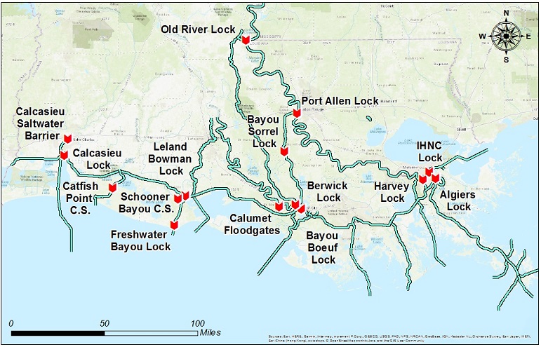
B) The Mississippi River is channeled through the NOLA area!
• There is a NOLA bowl graphic depicting Mississippi River levees as 21′ high. They used to be 21′ high.
• Courtesy of the Army Corps of Engineers and their multitude of Mississippi River drainage projects:
C) South Louisiana is host to a multitude of drainage locks to redirect Mississippi River waters.
 ?ver=2018-04-12-134938-360
• Even today, there are locks that have not been opened.
• Nor are all of the locks that are open operating at capacity.
• The Army Corps of Engineers and various Mississippi River lock managers are ready to open more spillways.
“New Orleans District Lock Status Updates”
D) Mississippi River flooding is excellent for South Louisiana bayous, swamps and land.
• The freshwater influx will deposit fresh desperately needed sediment and will freshen waters that are getting too salty for swampland wildlife.
• The Atchafalaya Basin can handle large amounts of excess Mississippi River water. A side result will be bumper crops of tasty Louisiana crawfish.
E) Tropical Storm Barry is projected to drop large amounts of rain to the west of New Orleans, not in New Orleans.
• Bob Breck, an excellent weatherman local to New Orleans posted this yesterday:
• Note the lack of concern about the Mississippi River.
Summary:

F) South Louisiana will experience a Tropical Storm or possibly a hurricane.
• New Orleans is not forecasted to experience torrential rainfall. Certainly nothing beyond normal.
• South Louisiana, including New Orleans, may and will experience local flash floods; again, nothing unprecedented.
• The Mississippi River drainage system and dikes are not in imminent danger of failure. Spillways and gates are ready to open to control Mississippi River levels.
What will endanger the Mississippi River system is if Tropical Storm Barry continues north into America’s Midwest. Rainfall in America’s Midwest does increase Mississippi River flood levels.
Most storms or sub-tropical systems entering Louisiana from the Gulf swing to the northeast; not head straight north.
Rainfall in Southern Louisiana generally does not drain into the Mississippi River. Until TS Barry dumps rainfall directly into those northern Mississippi River drainage areas, flood risk to New Orleans from the Mississippi River is low.
ATheoK, thanks, nice compilation of info.
ATheok, tbe flooding concerns for NO associated with Barry, other than overwhelming the pumping system (last I saw it was rated for 1″ for the 1st hour and 0.5″ each addtional hour, not 2″ per hour) were associated with storm surge. The Mississippi crest was to be high but brief. Storm surge predictions were reduced yesterday.
I know there has been confusion over levee heights. One othet caveat to mention is that that there are multiple vertical datums. I recently worked on a project within a few miles from the Gulf in FL where the NAD83 elevations had to be adjusted 0.99ft lower than the NGVD29 elevations the client used to use. 10 miles inland, this adjustment was more like 3ft. And I know from experience that the Army Corps often has their own datums on major rivers. So when we say 20ft vs 21ft vs 25ft…they could all represent the same thing if representing different datums.
re: “E) Tropical Storm Barry is projected to drop large amounts of rain to the west of New Orleans, not in New Orleans.”
I don’t know if you have access to the US’s weather RADAR assets available for viewing in near real-time the falling of precipitation from the skies, but, New Orleans has seen a fair amount of rain the past hour and is in-line for more given current observations with RADAR and satellite, and seeing how they are on the winds-off-the-Gulf side of the storm …
We’re seeing an outer cloud band (on satellite, as well as scattered, broken from ground obs) in north central Texas (Dallas) as I write this.
There is a good reason why Louisiana does not drain into the Mississippi River: It is mostly higher than the surrounding lands in much of it’s southern extent.
There are places where the BOTTOM of the river are above the height of the land.
One has to wonder how long the army corp can defy the natural process by which this river has always operated to deposit sediment across a very wide floodplain and delta.
I spent the evening yesterday listening to a young “Meteorologist” say that low pressure made the Gulf water rise? He reemphasized that several times. I must have missed that in my education…
It’s true.
Low pressure does cause a rise in sea level
Have a look at… https://www.smhi.se/en/theme/air-pressure-and-sea-level-1.12266
or
https://en.wikipedia.org/wiki/Cyclone [Tropical section in particular]
Strong low pressure systems do create a slight rise in waters underneath the center due to lower air pressure above the water.
Moving low pressure systems, especially those whose velocity match water wave speed in shallow water can produce a very large surge. It is not the low pressure per se, but the interaction of shelf depth, slope and storm speed.
” How can you blame “man-made climate change” when the result was exactly opposite of what was being predicted?”
Easy, it is man’s fault that the climate doesn’t change the way the change was predicted. /sarc
In the beginning there was the word,
and the word was CHANGED.
Joe Bastardi hits it out of the park again!
When it comes to NO, having part of your city at sea level and the other part below sea level is indeed a disaster waiting to happen. Man will never be able to alter what is happening and the best thing to do is move to higher ground.
Don’t tell the Dutch ….. 😉
Joe is so right. Climate alarmists are like silly day traders. Which ever way the weather is blowing that becomes the trend du jour worsened by climate change.
Indeed, when there was drought Hansen and Joe Romme and others were pushing a new dust bowl. They just keep moving the goal posts.
In 2011 Nature featured a climate rant by Romme “The Next Dust Bowl”
“Which impact of anthropogenic global warming will harm the most people in the coming decades? I believe that the answer is extended or permanent drought over large parts of currently habitable or arable land — a drastic change in climate that will threaten food security and may be irreversible over centuries.
A basic prediction of climate science is that many parts of the world will experience longer and deeper droughts, thanks to the synergistic effects of drying, warming and the melting of snow and ice.”
“As far back as 1990, scientists at NASA’s Goddard Institute for Space Studies in New York projected that severe to extreme drought in the United States, then occurring every 20 years or so, could become an every-other-year phenomenon by mid-century. Events are starting to bear out these worrying predictions. Snowpack reduction, early snowmelt and a decrease in dry-season river flow in the American West, forecast more than two decades ago, have now been measured”
“In 2011 Nature featured a climate rant by Romme “The Next Dust Bowl”
And here in the former Dust Bowl we have had more rain than we know what to do with. The excess is somewhere down around Louisiana right now in the Mississippi river.
One thing I have noticed about Climate Alarmists is they seem to think that once a trend starts going, it will continue on forever. They think we should be getting drier and drier because we were dry once, and they think we are going to get hotter and hotter because we were hot once. They don’t seem to understand cycles where weather is sometimes drier and sometimes wetter, and temperatures are sometimes hotter and sometimes cooler. Linear, horse-blinder thinking.
I wonder what Romme’s latest prediction is. Never mind, I don’t want to know. It makes no difference. it’s bound to be wrong considering history.
Unfortunately, human stupidity does not appear to be cyclical like climate/weather. Human stupidity seems to correlate well with the atmospheric CO2 concentration curve.
Albert Einstein always said that Human Stupidity was infinite. He was definitely right about that.
I think their strategy is to scream very loudly about every drought and every hot day and any time an ice cube melts, and the rest of the time say nothing at all, or just keep talking about the hot or dry times or the melted ice cube as if it was still happening.
The media complicity is critical to maintaining the fiction amongst the gullible.
The world is a big place, and at any given time, there is someplace having a heat wave, drought, or some other weather related story in which all is not well.
By only ever talking about the bad news, the perception can be built of unending disaster, hence this nonexistent climate crisis which entire governments have ruled is occurring in real time, and activists who have a full time career travelling around the world on “Please Panic Now” tours.
Meanwhile, away from the nonsense, the every place in the world has conditions that are well within the range of normal fluctuations, with an occasional trend towards the edges of this range.
There is nothing abnormal about conditions which range to the extremes of dry/wet or hot/cold every now and then.
And how anyone could come to the conclusion that a warmer climate would cause less rain is a mystery. More heat absorbed by the ocean = more evaporation = more rain.
We now have a new category of storms. Barry is now referred to as “on the edge of hurricane status”.
I guess strong tropical storm wasn’t scary enough.
Obviously the Trump Administration is gagging NOAA and covering up an entirely new type of hurricane: The Category 0.7
/Sarc
The NHC has now classified it as a hurricane, saying this, “Based on these data and the
possibility that the strongest winds were not sampled, it is estimated that Barry became a hurricane around 11-12Z despite its less than classical appearance in satellite imagery.”
Data that it has actually hit hurricane strength? We don’t need no stinkin’ data – we can assume we didn’t sample the strongest winds (perhaps they are hiding in the clouds?), and call it a ‘cane. Additionally, hurricanes and tropical storms in the very resent past have been declared based on air pressure readings alone, with only models predicting the wind speeds.
Why send out the planes at all if you aren’t going to accept the data?
Now, none if that changes what the storms do, but don’t give me comparisons with storms of the past unless you can give me unqualified assurance that the strengths and wind speeds of all the storms were determined using the same metrics.
A climate change “science” at its best.
I was looking, and apparently they never sent out any reconnaissance planes to this storm.
AFAICT.
This was no where close to a Hurricane.
But by next Winter, when memories have grown dimmer, it will be reclassified as a cat 4 or 5 I am sure.
That is what they did with Mathew after it hit, even though they were already exaggerating it in real time.
We know what a strong hurricane does: It drowns people who are 20 miles inland in the ocean surge, and crap like that.
After Mathew passed, there were houses on the beach right in the place most directly hit, that were completely undamaged.
“Climate Change” storm chasers.
Do any of the models do much with the heat budget of the ocean? I worked in the Atchafalaya Bay area during the floods of the 70s (73-75) and the important feature was how cold the river was even into the Gulf. New Orleans temperatures are delayed in the spring from the river and a third of the water is now going down the Atchafalaya River. In the 70s floods with the Morganza spillway open it dominated the bay and nearshore and even pushed the fish communities offshore. There are early satellite photos showing the turbid water well offshore moving west. This seems late in the season, but when the river floods cold water critters come with it. I recall a walleye and somebody studied the cold water plankton in the Atchafalaya Basin.
These storms interact with the ocean, destroy the thermocline, change currents, have long wondered about ocean effects, and discussed it with others since the 70s. Every storm is different and runs into different conditions.
Apparently Barry is a bigger problem because of climate disruption along the entire Mississippi corridor.
“The increasing frequency of heavy rain, both globally and in the Mississippi River Basin specifically, is among the clearest climate change impacts on weather. A warmer atmosphere holds more water vapor.Feb 28, 2017
Climate Impacts Along the Mississippi River Corridor | Climate Nexus
Look at the long list called “Climate Impacts Toplines:”
https://climatenexus.org/climate-change-us/climate-impacts-along-the-mississippi-river-corridor/
https://en.wikipedia.org/wiki/Great_Mississippi_Flood_of_1927
The Mississippi River basin folks can and should act locally to improve water resource (including quality) and flooding issues. Much of it is common sense. The climate change bogey/boogeyman is a misguided target.
Climate change apparently can accomplish almost anything – as long as it is bad. On the other hand…
https://www.sciencedirect.com/science/article/pii/S002216941730478X#%21
Highlights
•Trends in major-floods from 1204 sites in North America and Europe are assessed.
•Trends based on counting exceedances of flood thresholds for groups of gauges.
•The number of significant trends was about the number expected due to chance alone.
•Changes in the frequency of major floods are dominated by multidecadal variability.
Except ample rain is exactly the opposite of what alarmists have long claimed for the world in general and this area specifically and in particular.
Spring flooding has been a fact of life along this river since people moved to live near and farm the rich soil of it’s floodplain.
NEWSFLASH: People that live in the floodplain, delta, and outwash regions of rivers than drain entire continents are gonna have flooding.
Film at 11:00
Why is it, do you suppose, that this river (and it many tributaries) is the most managed waterway on Earth?
Thousands upon thousands of miles of levees, floodgates, locks, dams, and all manner of flood control measures exist on this waterway.
It is not because they have been planning ahead for the flood that had never happened and now finally has.
Channelizing a mature meandering river on a floodplain, one which has always carried a huge sediment load, and preventing it from doing what is natural and normal and healthy for such a river to do, which is flood the flood plain with sediment laden water, is only one of the many reasons for what has happened this year.
The river has of course always flooded. Anyone who has ever taken even a first year class in High School physical geography knows this well. It is one of the most important and relevant aspects to the daily lives of many people.
In fact the river carries so much sediment, it has regularly changed it course along the floodplain ever so often, as the stream bed becomes built up by sediment, meanders become more extreme (deposition along slow moving inner side of curves, erosion of the bank along the outside of curves), and then a flood from heavy stream flow throws the river out of its banks.
The river will spill out across the flood plain and renourish it with sediment.
As the flow returns to more normal volume, the river may find lower and more direct route downstream, and this in fact regularly happens when such a river is not messed with by building levees and keeping from doing what it wants to do. Because the previous path contains many convolutions, when these are bypassed what is seen are features called oxbow lakes. A look at an aerial shot of the Mississippi floodplain shows thousands and thousands of these, of every age, and some features that are old ones that have filled in and become part of the plain again. If the river finds an entirely new path along the floodplain, entire sections of the old stream bed will be cutoff, and these will be visible as lakes that are long and sinuous. Sometimes the river will bifurcate, and the flow will be split for a distance.
And all of this must occur for the river and floodplain to exist in the state it was in when we found it.
Anyplace that is flooded by these rivers, which have travelled the same general path for many millions of years, has flooded because they built upon the floodplain of a river.
If there is any tendency towards more frequent or worse flooding than our historical records suggest (only suggest), there is a simple explanation in that the river is channelized, it has not been about to find a lower pathway through the flood plain for a very long time, sediment is building up along the bottom of the bed every year (although at some point it may be the case that heavy flow will scour sediment off the bottom and transport it downstream), and the surrounding floodplain, cut off from it natural supply of periodic new sedimentation, is subsiding, via oxidation of organics, compaction, and groundwater withdraw.
Each of these processes that occur in a channelized mature river in a floodplain makes the potential flood if and when the river overflow the levees that much worse, as does continued construction along the path of the floodplain.
Here is a random photo of the river in it’s floodplain. Look carefully at the contours of the land outside of the river channel, and plainly visible, even after many decades of being channelized, are the features I described. Some are very old and exist only as a tracery in the land contour that farmers have plowed, some are oxbows, in various stages of their evolution towards being filled in, and some old straight channel lakes. In fact, the entire ground surface for many miles on either side of the river is overlapping layers of such features.
http://media.chicagomag.com/whet/mississippi_river_flood.jpg
Also, the Mississippi is not exactly one river. There are places where major rivers join it, and in these places, the character of the river changes. Once past the point where both the Ohio and Missouri rivers have joined the Mississippi, it changes entirely.
The flood plain is different south of St. Louis, and dramatically different south of Cairo.
Below this point the river goes from having a flood plain of a several miles width, to having a floodplain 50 to 100 miles wide. An area almost as large as the state of Tennessee.
You can seen old channels from one side to the other, most of which show up as particularly green and lush farm plots. For tens of millions of years the river has owned that whole extent.
Now it is restricted to the path it had on one particular day.
South of the confluence of the Red river, a large part of southern Louisiana was once a river delta in which the same sort of processes occurred, except that here the river would slow down and drop nearly all of it sediment load.
After while, the place where the river was doing this became not the lowest but the highest land in the delta, and so during a flood the river would find a new path, and start dropping sediment there. During big flood years, it may have spread to cover the entire delta for a while.
And this is why we see what we see there today: A huge city sitting on ground which is day by day become more compacted (and may be getting pushed down by 8mm/year from crustal loading and a hinge effect centered further inland), and so it gets a little lower every year. It is by now almost completely below sea level. The river itself is way above sea level here, and it’s kept from dropping it sediment, which is why the delta is gradually dying and receding, and the crow’s foot of sediment grows further into the Gulf, and the “dead zone” (really a zone of hypoxia due to eutrophication) where it drops it’s nutrient laden water to mix w/ the Gulf water, remains.
This entire area is several disasters waiting to happen, but none of them have anything to do with global warming, changing climates, or any of that nonsense.
River sediment is not some new thing, but pretending we are in charge of the forces of nature on our planet is.
By the time the Army corps confined the river to it’s present path, it already wanted to make a new way for itself to the Gulf, north of Baton Rouge and then trending SW, along a path roughly where the Atchafalaya river now is.
At this point, the river is far higher than the Atchafalaya river pathway.
Many felt for a very long time that the Corps of Engineers was forestalling the inevitable, and making the flooding which would someday surely throw the river from it banks and make a new channel in a more direct and lower path to the gulf, that much worse when it happened.
Personally, when I learned all of this back in High School and in great detail in college, I was sure sooner or later a flood like the worst in history would come again.
It is thought that if the river ever gets out of it’s channel, it will quickly cut a new stream bed into soft sediment and it will become nearly impossible to ever force it back.
It can be seen that the river is a continuous series of sinuous loops and curlicues, which is how every mature river on a flood plain looks. There are many miles of river for every mile of distance as the crow flies.
BTW, here are a few links.
First one is a satellite view of the flood plain and delta region in Louisiana, showing a typical assemblage of old stream channels and oxbow lakes by the dozen.
Second is a MIT physical geography summary of the region, and a quick primer on what I was relating from memory above:
https://www.bing.com/maps?q=Cairo+missourri&form=EDNTHT&mkt=en-us&httpsmsn=1&plvar=0&refig=cd70fd8b59d14b979ba3753eaec85dbf&PC=HCTS&sp=-1&pq=cairo+missourri&sc=8-15&qs=n&sk=&cvid=cd70fd8b59d14b979ba3753eaec85dbf
http://web.mit.edu/12.000/www/m2010/finalwebsite/background/mississippiriver/mississippi-general.html
The storm will move north on the west side of the Mississippi Valley. In the southeast, jetstream loop will be created, which will bring rains and thunderstorms.
Watching a weather dude in full man on the scene weather channel regalia, interviewing a city official in New Orleans.
There appeared to be not the faintest breeze, nary a drop of rain…the street was dry and crowded with pedestrians.
And we are to believe that storm sitting just to the west is a hurricane?
I think they have decided to make any windy tropical system a hurricane, no matter what winds at the surface are doing.
Looking at barometric pressure, this barely classifies as stormy weather. 996 mb.
It’s not lost on me that the states that have the highest percentage of climate deniers get the highest consequences. The storm may not have been caused by AGW, but simple physics says it was certainly worsened by it.
Not according to the IPCC and NCA. There is no trends in numbers or strengths, in storms, droughts or floods; globally or the USA.
You knowledge of politics is also suspect. While the states may be red, the cities of Houston and NOLA are deep blue. Of course, these cities have had the greatest impact of recent hurricane history.
Well, actually, Wyoming and others are not affected. Too bad.
Bad why do you need IPCC? If the water is hotter there is more evaporation. Even those with lower than normal intelligence should realize the consequences.
I assume you are talking of your own intelligence here. Because the IPCC and NCA both say there are no trends in storms, droughts or FLOODS.
Even one with a room temperature IQ should be able to understand the significance of that.
Add to that the fact that the rest of the world (particularly the western Pacific) has been experiencing an anomalous low in cyclonic activity of late. Something that would surely be viewed as “unprecedented” by the media, had it fit the current agenda. Tidbits like that (along with 2018’s quiet US tornado statistics) fail to appear in our “balanced” media outlets.
Some nebulous and impossible to point to “climate change” has nothing to do with physics, and storm intensity is affected by specific factors.
You say that a changing climate has to, because physics, lead to worse storms, implies inanely that there was a time climate did not change, that at that magical point in time storms were at the very least intensity and frequency, and that thus any nudge in any direction has to make them worse, as there is no place to go but towards “worse”.
You should say what you really mean to say: That the world is heating up, and the air and the oceans are hotter than evah, and that storms are fed by heat, and therefore of course they are all worse now, no matter how bad or not so bad they are.
These are the only way what you said could logically make even a tiny bit of sense.
But the sea is not any warmer then historically has always been the case, it is well inside the bounds of normal variation.
It is not anomalously hot or humid in this area, and so there is no source of heat that can only be explained by man made CO2 in the air.
In fact, no one can show CO2 has even a slight effect on average global temps. Maybe so, maybe no.
And all of this completely misses the point about tropical storms and hurricanes.
We have been in a long and unprecedented lull in such storms in the Gulf of Mexico and the US in General.
We have never see so few of them as for the last 14 years.
And warmer weather is not what makes more of them form.
If that was true, we would see more in el nino years, but we do not.
In the Atlantic basin, it is precisely the opposite: Hurricanes and T.S.’s are anti-correlated with el nino.
You are as wrong as wrong can be Trafamadore.
Which is what usually happens when people just make crap up out of thin air.
I’ve been watching Doppler radar and…
By God, if something like this massive, climate change-aided superstorm hit m us here in the St. Louis area, it would be…
Pretty much business as usual.
Aside from the high river levels, what’s so special here?
So far, not seeing near the amount of rain in and about NOLA as what was expected … and now, the last hour or so, the ‘center’ (as observed on RADAR) can be seen moving NNW at last.
3 nights ago Low Head in Tasmania had a gust of 103kmh. Gale force winds were predicted so no surprise. Turn on the tv and and shock horror New Orleans is doomed because winds of up to 110kmh will batter the coast from tropical storm Barry. The top end of Tasmania clearly isn’t as sensational as New Orleans.
There was less wind damage from this storm than commonly occurs from ordinary thunderstorms anywhere in the world.
Some trees blew down, a few structures had roof damage.
It’s very frustrating to live here and watch the constant outpouring of hate from the major news media. It’s become pretty apparent they want us all to die, and I’m not sure what we ever did to them. Have good music? Be a competing port with NYC?
… there were predictions that a new dust bowl would develop …
Don’t knock the ‘dust bowl’. It caused a whole bunch of Okkies to move to California. Raised the average IQ of both states. (An old joke – just like me)