UPDATES BELOW
The latest GOES16 satellite closeup of the eye of Hurricane Michael at landfall.

Live Source here
This morning, it has further intensified and now stands on the threshold of a CAT5 storm. It would become Cat5 at 156mph sustained winds.
NASA: Max sustained winds in high-end Cat 4 #Hurricane #Michael have unfortunately continued to intensify, now at 150 MPH! Pressure down to 27.26″. (@NOAA GOES-East 30-sec vis imagery)
Source: https://twitter.com/NASA_SPoRT/status/1050048660648710144
UPDATES:
https://twitter.com/RyanMaue/status/1050051973972721664
https://twitter.com/RyanMaue/status/1050065771701948417
High-end Cat. 4 #Hurricane #Michael now making landfall between Tyndall AFB and Mexico Beach, FL with *sustained* winds of 150 MPH. Pressure down to 919 MB (27.14"). (@NOAA GOES-East vis imagery) pic.twitter.com/hp1X9RF8aT
— NASA SPoRT (@NASA_SPoRT) October 10, 2018
Per @NHC_Atlantic, #Hurricane #Michael made landfall just NW of Mexico Beach, FL. Max sustained winds were an astounding 155 MPH, just 1 MPH shy of Cat. 5 status. Pressure was 919 MB (27.41"). (@NOAA GOES-East longwave IR imagery) pic.twitter.com/tXMM6wm8rb
— NASA SPoRT (@NASA_SPoRT) October 10, 2018
The gap between hype and reality of Michael – is one of the most intense BS storms the Florida Handle has ever experienced. pic.twitter.com/wHubUFOmuk
— Tony Heller (@Tony__Heller) October 10, 2018
Of course warm Gulf of Mexico water is blamed upon man-made “climate change”:
https://www.yahoo.com/news/turbocharged-michael-got-55-percent-stronger-1-day-163036830.html
Panama City in the eye of a hurricane.

OK, could be windier than Apalachicola. Thanks to John Pickens we have https://www.windfinder.com/report/lower_grand_lagoon_panama_city and winds still increasing and barometer falling as at noon local. But isn’t noon a little out of date?
Yes, 1:17pm of my comment refers to PDT I think, so it must be 3:17pm or 4:17pm now in Panama City. Perhaps the equipment has broken and we won’t see their maximum wind speeds. John Pickens whaddya think?
Any Weather Channel guys there?
Looks like the data feed crapped out at 12:15pm local time. Sustained winds of 64mph at that time. I very much doubt it ever reached 110mph sustained, but we may never know from this weather station.
The damage to Tyndall AFB will be enormous, very much like Homestead AFB, FL in 1992 after Andrew.
Hurricane Andrew wiped Homestead Florida off the map in late August 1992.
Any guesses on when the period of Rapid Intensification for Andrew occurred from this historical plot of Ap Index?
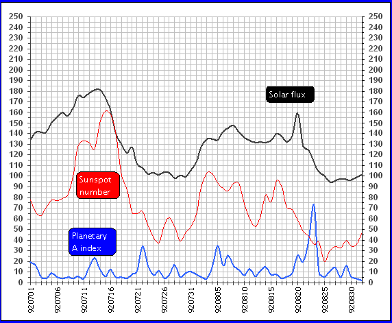
Geomagnetic Ap index spiked this past Monday Tuesday, not quite as high as forecast, but still spiked. That coincides with Hurricane Michael’s rapid intensification over these past 48 hours.
One can go back to 2017 and see the same sort of intensification for Hurricanes Irma and Maria coinciding with the whopper Ap spike as Maria was bearing down on Guadeloupe in the Lesser Antilles. Irma stayed an amazing Cat 5 for 5 days from Sept 5 to Sept 9 as Ap index hit it highest level of Solar Cycle 24.
Certainly an Ap spikes by themselves are not sufficient to bring on a major hurricane development as there are exceptions where Ap spikes don’t correlate with hurricane development. For example the 2015 hurricane season was a minimal Atlantic hurricane year, likely due to the very strong El Nino in the eastern equatorial Pacific through the hurricane season keeping the wind shear high over the tropical Atlantic.
So other factors must also be in place, such as water temps, broad pressure patterns, and maybe a neutral/near-neutral ENSO. But there does appear to be a role for Ap spikes assisting in shifting the atmospherics toward one favorable for hurricane development and intensification.
Joel, you should do some statistics on that Ap index stuff, and prove a correlation. Otherwise it’s just anecdotal I fear.
Re the damage to Tyndall AFB, let’s see. Above I wrote “Tyndall peaked at 75kt sustained and 112kt gust”. So the sustained wind was probably OKish, but that is a big gust differential, and that 130mph really may have done some damage. Hope everyone was hunkered down, or absent.
The big damage to Tyndall AFB will be the storm surge flooding in the housing and base facilities with salt water.
Tyndall AFB has a listed airfield elevation of 7 feet. That would be the ends of the main runway. Most of the main part of the air base is between 4 to 12 feet.
So, interpolating between 5.3 feet above MHHW at Panama City and 7.7 feet above MHHW at Apalachicola, puts Tyndall AFB at 6.5 feet above MHHW from Michael’s storm surge.
I think the airport elevations are a few feet higher than you mention.
The FAA taxi diagram has specific heights – http://155.178.201.160/d-tpp/1811/00312AD.PDF
I think a little higher per the FAA – http://155.178.201.160/d-tpp/1811/00312AD.PDF
Saffir-Simpson wind scale only uses sustained winds to define tropical storm categories.
Yup, and it has to be 74mph sustained to be considered Cat 1 hurricane. I have seen no stations reporting this. What Michael is is a Tropical Storm at landfall. Fake News all day long…
Dunno, just saw a local TV twit intrviewing a fish that washed ashore…
The pictures of structural and roof damage coming out suggest 110-115 mph sustained winds were present around Panama City. Cat 3-ish.
There are pictures of what looks like cat 2 to cat 3 damage including some snapped ( not fell down) pine trees.
Yet I see no ground level signs of strong cat 4 on the ground. Highest storm surge so far reported is be low 8′
The next named TC for 2018, Tropical Storm Nadine has just formed out in the eastern Atlantic development region. Currently Nadine’s max winds 63 MPH and 993 mb central pressure estimate at 12.6 N 31.6 W headed west-northwest, at least a 7-10 days out from any significant landfall.
And the next Ap spike is forecast for around 19 October. So “If” Nadine is still over favorable waters for strengthening, expect it to do so then. And in 9 days that could put it bearing down on Florida or into the Gulf of Mexico where the waters are still quite warm. Or she could just get steered off into the North Atlantic near Bermuda. Too early to tell her track.
The increased activity of the geomagnetic increases speed of the jet streams in the upper atmosphere.
Eye of the hurricane moves northeast.
South Carolina is threatened by flooding.
https://www.tropicaltidbits.com/sat/satlooper.php?region=14L&product=wv-mid
Storm is past landfall, about over Tallahassee at 4.40 pm local time
No land based or offshore NDBC stations have recorded sustained winds reaching Category 1
Station SGOF1, Tyndall AFB tower, anemometer at 35 meters above sea level
https://www.ndbc.noaa.gov/station_page.php?station=sgof1
61 knots maximum sustained at noon
Panama Beach station PCBF1 recorded 53 knots at 3.06 pm
Anemometer height 8.6 meters
Apalachicola station showed around 50 knots, but anemometer height under 10 meters
Another COOP station, 8728690 Apalachicola,using Tides and Currents site shows about 54 knots maximum
at around noon
https://tidesandcurrents.noaa.gov/met.html?id=8728690
National Weather Service at Tallahassee Int. Airport recorded maximum sustained winds in the 40 mph range while the real time radar was showing the eyewall directly over the airport.
It is now 5:09pm EST, and the NWS/NHC website lists “Hurricane” Michael as a “Major” hurricane with maximum sustained winds of 125mph. Yet, there are no ground stations reporting sustained winds of greater than 74mph. This storm landed as a Tropical Storm. Why is this happening?
Does anyone know of an actual report of a weather station in the effected area which reported anything near hurricane force sustained winds? I’ve been scanning websites, and I cannot find one.
This is a farce.
“Hurricane-force winds extend outward up to 40 miles (65 km) from the
center and tropical-storm-force winds extend outward up to 160 miles
(260 km). A wind gust to 69 mph (111 km/h) was recently reported
at the airport in Tallahassee, Florida. A sustained wind of 59 mph
(96 km/h) with a gust to 74 mph (118 km/h) was observed at a
University of Florida/Weatherflow observing site just north of St.
George Island, Florida.”
https://www.nhc.noaa.gov/text/refresh/MIATCPAT4+shtml/072339.shtml?
Yeah, well there they are using the word “wind” for gusts rather than sustained winds, which is a bit of a cheat, making people think they’ve been in a hurricane rather than a tropical storm. And they immediately throw in km/h to make it sound more scary.
You’re right. They write about gusts.
Well, John, we saw upthread that Panama City stopped recording around 12:15pm when the sustained wind was close on 74mph, still apparently increasing, and with the barometer still diving. So I think we can be pretty sure the winds continued to increase. But up to what Category? It certainly would be nice to have solid data, I agree, but unlike some other hurricanes I have commented about, especially Sandy, I am reasonably persuaded that this was a landfalling hurricane.
Reports from the Hurricane Hunter Air Force Reserve show an inflated wind speed.
Some severe wind damage has been recorded:
Shell structures for storage (like boats) don’t withstand much wind (and the boats look like they are still safely inside). The residential condo in the background looks unscathed.
I feel for those with damage, I’m sure a lot of roofs were damaged, but I drove the coast after both Camille and Katrina, and so far I haven’t seen anything approaching the devestation caused by those storms. I hope that continues to be the case.
I snowbird in PSJ so I know the area. Brett made a mistake by leaving Port St. Joe which is protected by St. Joe Bay and the Cape San Blas barrier Island. Mexico Beach has no protection, US 98 is 50 yards from the Gulf. His last video was not pretty, even if they made up to the second floor the house could easily have been undermined by the surge running back to the Gulf. Not good.
When all you with your high and mighty opinions see the actual damage I hope you have the same guts to offer your apologies for being wrong.
Tom, your post came in while I was typing mine which should follow. Hope you were not affected.
No, I am well south in Venice. But as all of us in Florida know, I would rather have them be wrong on the lesser side than be caught unprepared for what just happened. ABC news had the best live coverage and it was devastatingly awesome.
So here is the gust info from this storm as of a short time ago.
This was a 155 mph sustained wind storm as conveyed by the NHC. The AFB noted is right at the point of impact for this storm, and right on the water. What I am I missing with intensity?
https://mobile.twitter.com/crankywxguy/status/1050178708928118784
Pensacola dodged a bullet.
“Blessed are those that experience a NH Hurricane on the west side of the storm. And, woe to those to the east.”
Much will be made of Michael, deservedly so as the people in the affected areas will suffer from lack of power and all the comforts that electricity brings, possibly loss of water and sewage disposal, perhaps little food if not prepared, lack of communication services, maybe little access to medical help, exposure to the elements, flooding, the stress of losing much, if not all, of the things people treasure, maybe trauma from the loss of friends and relatives……get the picture? Its not the technical aspects that are important, its the damage that is caused. Fortunately, if that is the proper word, Michael affected a less populated area of our state but that’s little comfort to those that reside there.
Pensacola is similar to the Panama City area. Smaller, large military presence, coastal and, thus, exposed but we had not had a direct hit from a hurricane hit for decades until 1995 when Erin visited followed by a near miss from Opal. Mobile, AL was hit by Frederick in 1979 and Pensacola experienced some effects but the last hits were from the “Decade Storms in 1906, 1916 and 1926. What an eye-opener for the area as the collective historical memory had receded. Then, we went through the “eye” of Erin and Opal veered to the east at the last minute it seemed. Pensacola was hit again in 2004 from Ivan (we were in, or near, the east eyewall, an exciting experience) and again in 2005 from Dennis (we were in, or near, the west eyewall) and had a glancing blow from Katrina in 2006. Instantly in 1995 and then for a span of about 10 years the collective memory was re-awakened and reinforced several times! Our neighbors to the east will be experiencing that feeling now.
We have a large oak in the backyard, a LARGE oak. Ivan leaned it one way, Dennis back the opposite way, and Katrina straightened back up to the vertical. A natural weathervane. Funny how the mind works. I rate hurricane intensity at my house by how many days the power is out: Erin for 3.5 days (Cat 1 but a direct hit), Opal for 3.5 days (Cat 3 at landfall but read more below; stronger but not as close), Ivan for 9 days (Cat 3 and direct hit), Dennis for 3 days (Cat 3 but west side), Katrina for 1.5 days (Cat 3-5, Cat 3 at landfall but farther away from Pensacola), Michael for 0 days. However, in each of those cases there are people who were affected much more. lost much more including their lives. Its not the wind, pressure, etc. ratings; its the impact.
Opal was an interesting storm and I told my younger son, who lives to the east of Destin, to keep a close eye (no pun) on Michael as it reminded of Opal. As Opal was headed north, straight for Pensacola in 1995, it was designated a hurricane on October 2 and strengthened to a Cat 4 by October 4 fueled by unusually warm water thought to be associated with the Loop Current. As Michael was traversing nearly the same waters I told my son to watch for rapid strengthening which turned out to be the case.
Michael is not the first storm of this strength to hit the northern Gulf Coast. Camille (1969) was stronger, Katrina was devastating (a Cat 5 at one point) and Opal achieved a 155 mph winds before weakening to a Cat prior to landfall. But it is the strongest to hit the Florida panhandle, and as I said, any hurricane is a bad day if it comes to your house.
We prepared well prior to each of our hurricane visitors and got better at it each year. After Katrina in 2006 we installed a whole-house generator and hardened the house through FEMA’s Wind Mitigation Program which I highly recommend for anyone in hurricane country (and tornado country). We are only a few miles from the coast but at 80 feet MSL so storm surge and flooding are not an issue for us and surge/flooding are the major killers during these storms.
It took several years to recover from Ivan. Major bridges in the area were unusable. Beach areas were rearranged and had no services for months, tens of thousands of structure were destroyed and tree canopies were reduced by about 80%. Housing was in very short supply and home prices skyrocketed. A benefit: no insects! It took me eleven days to clear debris from the property but not a flying insect in sight. They were all blown north with the storm! But, they were back about 14 days later.
So, as the debate will rage about strength of a storm, remember the impact on people’s lives. As coastal development and population increases, the impacts will be greater, recovery costs greater (particularly with inflation) but, hopefully, development will be smarter. Our Panhandle, Big Bend and west Coast Florida neighbors will recover. Some faster than others. Some with life-changing memories. All with a new perspective on what is important. I’ve been through a number of hurricanes, even more tropical storms, and they are a marvelous and frightening display of power and deserve much respect. I know that many of you have as well or have experienced a tornado (I remember going through Grand Island, NE decades ago after the town was essentially wiped from the face of the planet), or earthquake (been there, too), or an explosion, fire or war. Leaves a mark.
Oh, a final comment, as for hurricanes: its weather, just weather.
Sorry for the wordy post.
Erin took out all the sand pines in my back yard with its slow approach and heavy rains. The trees just laid over, their root balls lifting out of the sand. Power out for 4 days. Then 2 months later Opal went right over my house in Navarre took off half the roof, dropped much of the sheet rock ceiling inside with insulation everywhere. Power out for 4-5 days. I love the beach and water, but I left Florida forever 6 months later (for permanent living) in June 1996.
Yes, the trees had no been pruned for decades. Erin did it. A lot of debris for a lowly Cat 1. Glad you and family made it through.
On October 4, 1995 at 1200 GMT Opal hit a minimum central pressure of 919 mb. It was very briefly a Cat 4, but really just a solid Cat 3 at 12 hours before landfall. Then it hit some colder water as it moved north toward the panhandle and made landfall right over my house as a minimal Cat2. (Iwas stuck in 40 mile long I-10 parking lot about 20 miles outside Tallahassee. I spent the night in my 4Runner with my wife and 3 small dogs along with 50,000 neighbors.
Looking at this (see URL) Ap plot from 1994 (blue line), can you spot where Hurrican Opal hit her peak intensity?
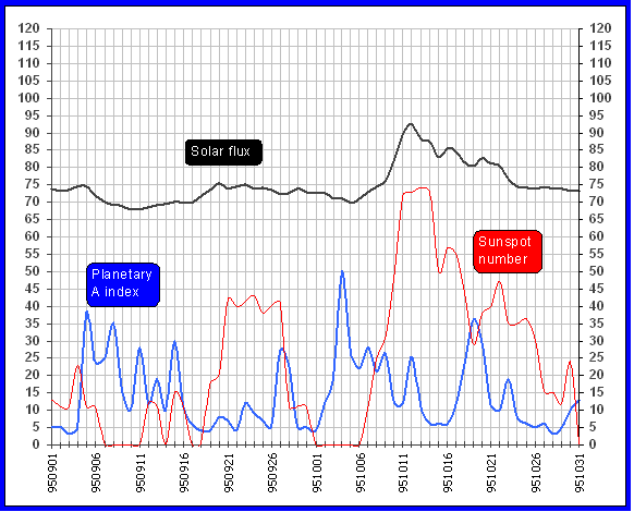
Correction That plot is from 1995 (not 1994), errr. (I miss edit.)
Yes if this storm had hit a little further west, the strong devastation could have hit Panama City. and there would have been Mucho Devastation there like what happened to Mexico Beach, which is much less populated. thankfully. And if hit further to the east Tallahassee would have been hit harder…etc.
CNN has already declared that global warming caused higher water temps and therefore stronger hurricane.
Surprise!
Been watching CNN reporting all day and they keep repeating that this is what we can expect because of climate change. And it is Climate Change as a matter of fact.
CNN is the only news channel I get on Dish TV here in Mexico, – that is in English…that’s why CNN.
Maybe you should get a different satellite TV provider…
Clearly, the Gulf of Mexico is HOT at this time of year. This is normal, and can cause hurricane strengthening. The SST has increased 0.03°C so far from CAGW? that is clearly not enough to have an effect on hurricanes. CNN is FAKE news.
Keep in mind that the NHC uses a 1-minute time average for their sustained winds. Observation stations use a 2-minute time average for computation of sustained wind. That can result in a significant difference between what NHC reports vs. what observation stations report.
This is not a “natural disaster” according to CNN and according to them, it is “dangerous” to talk about it in such a way. Much more dangerous to call it a natural disaster than the hurricane itself.
“”Hurricane Michael isn’t a truly “natural disaster.”
Neither was Harvey in Houston.
Nor Maria in Puerto Rico.
Yet we continue to use that term.
Doing so — especially in the era of climate change — is misleading if not dangerous, according to several disaster experts and climate scientists I reached by phone and on Twitter.”
Climate denial kills? Thank you, Mayor De Blasio.
Question: If there have been several other Cat 4 hurricanes to hit this one little area of FL since 1886, which ones were natural, which were unnatural and why? Follow-up: Before 1886, what makes you think there were no hurricanes of similar and greater magnitude?
Natural disasters aren’t disastrous enough?
The cold front will cause heavy rainfall in the east of the US.

Why do I not see much of anything on nullschoolearth?
The human mind rejects disaster and mistakenly regards it all as “unnatural.” Natural disasters are natural and normal.
I have to say that the Weather Channel did a really good job of covering the hurricane.
The live feeds were constantly checking to make sure their info was correct.
Any Faux Pas was almost instantly corrected by the sleep deprived reporter.
Pretty good stuff.