Antarctica: Return of the Weddell polynya supports Kiel climate model
After 40 years, a large ice-free area appears again in the Southern Ocean in mid-winter
Currently, winter has still a firm grip on Antarctica. At this time of the year, the Weddell Sea usually is covered with a thick layer of sea ice. In spite of the icy temperatures in the region, satellite images depict a large ice-free area in the middle of the ice cover. The area of the hole in the ice is larger than The Netherlands and it fascinates climate and polar researchers worldwide. Scientists from the GEOMAR Helmholtz Centre for Ocean Research Kiel are closely monitoring the developments. “For us this ice-free area is an important new data point which we can use to validate our climate models. Its occurrence after several decades also confirms our previous calculations,” says Dr. Torge Martin, meteorologist and climate modeler in the GEOMAR Research Division “Oceans Circulation and Climate Dynamics”.

Polar researchers refer to a large ice-free area in otherwise frozen seas with the Russian word “polynya”. In the Arctic and Antarctic, polynyas occur regularly, but typically in coastal regions. They play an important role in the formation of new sea ice and deep water. In the open ocean, however, polynyas are rare. The so-called Weddell Polynya only once has been observed during the satellite era, namely in the mid-1970s. “At that time the scientific community had just launched the first satellites that provided images of the sea-ice cover from space. On-site measurements in the Southern Ocean still require enormous efforts, so they are quite limited,” says Dr. Martin.

Nevertheless, the Weddell Polynya is reasonably well understood. “The Southern Ocean is strongly stratified. A very cold but relatively fresh water layer covers a much warmer and saltier water mass, thus acting as an insulating layer,” explains Prof. Dr. Mojib Latif, head of the Research Division at GEOMAR. Under certain conditions, the warm water of the lower layer can reach the surface and melt the ice. “This is like opening a pressure relief valve – the ocean then releases a surplus of heat to the atmosphere for several consecutive winters until the heat reservoir is exhausted,” adds Professor Latif.
Yet two major questions remain: how often does the polynya occur and does climate change influence this process? “If there are hardly any observations, computer models help to simulate the interactions between the ocean, the atmosphere and the sea ice,” explains Dr. Annika Reintges, first author of the most recent study by the Kiel group about this topic. The models apply fundamental physical laws to simulate climate. Real data such as the bathymetry and actual climate observations used as a starting point provide a framework in which the models run.
Amazon Deal of the Day: 63% off on a HD recording Dashcam for your vehicle
However, data uncertainties lead to a range of results. “Therefore, we are always trying to compare the simulations with real phenomena to improve the models. Unfortunately, many data series are too short to evaluate the simulated climate variability with periods of several decades. We therefore also compare the models with each other,” says Dr. Reintges.
US-American scientists have calculated that the Weddell Polynya would probably not occur again because of climate change. Higher precipitation levels in the region and melting ice would decouple the surface from the deeper water layers. However, in several studies applying the “Kiel Climate Model” and other computer models, the research group in Kiel described the polynya as part of long-term natural variability, which would occur again sooner or later. “The fact that now a large, ice-free area can be observed in the Weddell Sea confirms our theory and gives us another data point for further model studies,” says Dr. Martin.
In general, the climate scientists at GEOMAR, like many colleagues around the world, are keen to differentiate natural climate variability from manmade changes. “Global warming is not a linear process and happens on top of internal variability inherent to the climate system. The better we understand these natural processes, the better we can identify the anthropogenic impact on the climate system”, resumes Professor Latif.
###
Where’s the newly discovered southern rim of the ring of fire in relation to that area?
The Antarctic Peninsula lies to the west of the Weddell Sea. The volcanoes are on the Pacific side of the peninsula and adjacent areas.
They’ve known those are there for a while, haven’t they? I was under the impression that something like 91 new volcanoes have recently been discovered, completing the ring of fire.
Except for a couple on the east (Weddell Sea) side of the Peninsula, the 91 newly discovered ones are all on the Pacific side, or the western Southern Ocean, if you prefer.
https://www.theguardian.com/world/2017/aug/12/scientists-discover-91-volcanos-antarctica
Thats what I mentioned above but still don’t know where the hole is relative to any volcanic activity.
Jim,
In terms of known volcanoes, it’s pretty far to the east. The polynya is in the middle of the Weddell Sea. The closest known volcanoes are on the Antarctic Peninsula. They’re not currently erupting. There is however volcanic activity on the other side of the Peninsula and farther along the coast of the mainland, off the Bellingshausen and Amundsen Seas.
Also on the Ross and Somov Seas.
This exchange has made me realize that I have tended to unconsciously view a top-down map of Antarctica through a western (as opposed to a Pacific hemisphere), non-polar hemisphere bias (ie, west = left, east = right). .From a polar hemisphere perspective (as in the image above), all shorelines face north.
I Came,
That’s a common problem. I’ve had students ask me how there could be a West and East Antarctica. However, the continent very much has a Pacific side and an Atlantic-Indian Ocean side. That they meet complicates things, which is why some oceanographers prefer to think in terms of the Southern Ocean.
To further complicate matters, the Prime Meridian/International Date Line runs through the Princess Martha Coast of Queen Maud Land and the Ross Sea, plus the South Pole, of course.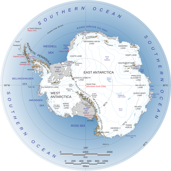
and Greenwich 🙂
Brrrrrrr!
I don’t know if this is accurate, or not. I thought that these had been known to exist before the recent announcement of the discovery of new volcanoes .
http://i.dailymail.co.uk/i/pix/2017/08/13/15/4339382700000578-4786564-image-a-42_1502634189572.jpg
That’s a map of the areas of the newly found 91 volcanoes, not those already known to exist.
Which, to complete the Ring of Fire, is where they would have to be, since it rings the Pacific.
“…polynyas occur regularly, but typically in coastal regions. They play an important role in the formation of new sea ice and deep water.”
How do polynyas play an important role in the formation of deep water? That has me scratching my head. Is “and” supposed to be “in”?
Yes, IMO.
Louis, Polynya are sea ice factories. As sea ice forms, dense cold brine is ejected, sinking to the sea floor. That cold brine forms the most dense sea water possible, assuming no major differences in salinity, thus “seeks” the lowest point. Depending on topography that dense brine sinks and creates bottom water.
Google Earth has the Maude Seamount in close proximity to the hole. Gee do you think those are volcanoes?
IMO the Maude Seamount lies too far east. The Rosenthal is closer, but its top is deep.
The Rosenthal seamount is not in the same location as the red circled area on the map in the article. You might check that again. I am fairly certain that the Maud seamount is closer. There are many volcanoes in this region which may be suggesting a region of high heat flow in the earths crust.
The Maud Seamount is off Queen Maud Land, hence, east of the Weddell Sea, as its coordinates also show.
But you might be right. I don’t have precise coordinates for the Rosenthal SM.
Polynya have been commonly reported by natives in the Arctic regions for centuries and utilized as productive fishing and seal hunting locations.
This Antarctic Polynya disappeared roughly forty years ago, shortly before a slight global temperature increase began. It’s re-appearance may suggest a new general cooling period has begun.
Mankind’s records do not have enough history to know for sure, but I suggest this is not the work of the old demon Global Warming, or the softer and more encompassing Climate Change.
I think what we are about to see is a general cooling trend, which could be referred to as Climate Cycling.
I hope someone has checked for a volcano? If you think that’s a dumb question remember I’m in good company.
If the open water in the arctic ocean is causing cooling why is the arctic sea ice on the Norwegian European side of the Arctic growing faster than the arctic sea ice on the Alaskan Canadian side when it has melted more this summer on the latter side of the Arctic, an obvious reason would be that the sea surface temperatures on the former side of the arctic are still colder.
http://www.natice.noaa.gov/pub/ims/ims_gif/DATA/prvsnow_asiaeurope.gif
Donal Penman
Restate the premis of your question please. I cannot determine what you are asking, nor what conclusion you are challenging.
i would say the greater expanse of open water that side is subject to more ice growth inhibiting wave action this early in the freeze season . in a couple of weeks even the wind will struggle to stop it forming.
The Laptev Sea has a “lens” of fresher water, due to the amazing Lena River floods. The Lena River is the world’s tenth largest, and rises roughly sixty feet in August floods. The brackish water an top of the Laptev Sea refreezes at a higher temperature.
But this year the Siberian snow-cover is early, so the cold land-breeze pouring out to sea will be earlier as well. That needs to be factored in as well.
“The better we understand these natural processes, the better we can identify the anthropogenic impact on the climate system”, resumes Professor Latif.
Well in my opinion you don’t often hear those words. Actually saying that there is a lack of understanding of the natural processes.
The center of the polyna is 65 south latitude. At today’s date (Julian DOY = 275, 3 Oct) solar radiation at the top of atmosphere = 1359 watts/m^2, Antarctic sea ice albedo = 0.81, atmosphere clarity = 0.75
At today’s date, at -65 latitude, approximately 2330 watt-hrs of solar radiation are delivered to the a flat 1 meter x 1 meter surface over a 24 hour day.
Of that radiation, if antarctic sea ice is present at the average albedo of October sea ice down there, 443 watt-hours will be absorbed, and 1886 watt-hours will be reflected.
If open ocean water is present instead of sea ice (which – of course, is the definition of polyna!) then 2104 watt-hours will be absorbed, and 225 watt-hours will be reflected. (Assumes low waves, low winds. There is little difference if winds are present however.) This calculation calculates the solar elevation angle of the sun at each hour of the day, uses the water albedo at that SEA, then adds up the individual hour’s energy absorbed (or reflected).
So, over a 24 hour day at -65 latitude on Oct 3, “only” 1661 “extra” watt-hours would be absorbed into the polyna waters if the Antarctic sea ice melts. 69 watts extra energy into the exposed ocean water each hour.
However, Judith Curry found that open Arctic waters LOSE more than 3000 watts per day due to extra evaporation, increased long wave radiation from the warm ocean water into the atmosphere, increased convection losses, and reduced conduction. Notice the “fog” over the polyna? That’s the water losing heat and evaporating.
No evaporation losses (only sublimation) if sea ice is present.
The surface of the ice is losing heat from a surface at -20 deg C (253 deg K), not 2 to 4 degree C (277 deg K).
The surface of the ice losing heat to the air is -18 to -20 degrees. If open water is present, the water is convecting heat away based on a 2 to 4 degree water surface.
If winds are present (and this photo shows calm water), convection losses are even higher!
Thus, at this time of year, at that latitude of this particular polyna, the Antarctic Ocean is losing more heat than is gained by the “dark” exposed waters under the sea ice.
Up north, where the sun is substantially lower in the Arctic sky between mid August and late March, even MORE heat is being lost from the open water. And every subsequent day of “lost sea ice” during these months means even more heat loss.
Change the day of year? Change the latitude of the open water?
Well, you will get a different answer.
Pretty sure this proves beyond the slightest doubt, MY theory of a large UFO being under the water in EXACTLY that spot and she’s getting ready to take off! Mystery solved. You’re welcome.
Whale farts.
It’s not clear to me whether they were predicting that the ice would disappear, or that the hole in the ice would disappear, it being difficult to have a hole without a doughnut. Either way, I hope somebody has got a list of names of these scientists because they are sure to be back later, making more climate predictions that also turn out to be wrong.
Presumably they will once again compensate for lack of data by comparing one failed model with another failed model. By the magic of climate science this will lead them to a different answer that they believe to somehow be more correct.
I’m 55 years old and not nearly as smart as the people doing these studies. But i can’t help wonder. I don’t know how old the earth is without googling it. How can do we know what normal weather patterns are? We always say this is a hotter or colder winter or summer compared to normal. This makes me laugh. We have been keeping accurate climate change and weather conditions for 100 years or so? And the earth is how old? How do we know that this isn’t normal?
“…Unfortunately, many data series are too short to evaluate the simulated climate variability with periods of several decades. We therefore also compare the models with each other,”
Wow. So to replace “several decades of data”-which for “climate scientists” appear enough – they compare models…
Didn’t you used to do the weather on KHSL TV in Chico, CA?
Antarctic sea ice is still growing. Dunno whether it will exceed its September high or not.
Never mind the natural awakening of volcanoes worldwide due to the contributing factors predicted with the declining TSI. Never mind the massive caldera of recently active volcanoes under the polynya. It has to be what we at Agenda 21 central have identified as human consumption derived CO2, i.e., human caused climate change. Just read our reports and never question our minion science conglomerate. 97% of all know alien life forms agree that YOUR incessant need to consume is melting that patch of ice! Step in line deniers.
Thank goodness it was previously observed…imagine the headlines if not.