From the U.S. Government Occasionally Does Something Useful Department:
A 1.4-Billion-Pixel Map of the Gulf of Mexico Seafloor
The U.S. Bureau of Ocean Energy Management releases the highest-resolution bathymetry map of the region to date.
A new bathymetry map, created by integrating many 3-D seismic surveys, reveals the Gulf of Mexico’s seafloor in unprecedented detail. Above is a snippet of this map, roughly 220 kilometers wide, showing the central Gulf of Mexico’s complex morphology of salt domes and minibasins. Credit: BOEM
The geology of the Gulf of Mexico (GOM) is dynamic, driven not by plate tectonics but by the movement of subsurface bodies of salt. Salt deposits, a remnant of an ocean that existed some 200 million years ago, behave in a certain way when overlain by heavy sediments. They compact, deform, squeeze into cracks, and balloon into overlying material.
Such salt tectonics continue to sculpt the geologic strata and seafloor in the GOM like few other places on Earth. Because of this salt tectonism and a steady supply of sediment delivered to the basin by rivers, the GOM’s seafloor is a terrain continually in flux. Bathymetry is ripe with active faults and escarpments, slump blocks and slides, canyons and channels, sediment waves, pockmarks and mud volcanoes, and other natural oil and gas seeps.
The map is freely downloadable in several formats from the BOEM.From BOEM: “Figure 1. Northern Gulf of Mexico deepwater bathymetry grid created from 3D seismic surveys. The grid defines water depth with 1.4 billion 40-by-40 ft cells and is available in feet and meters. BOEM grid coverage is the area defined by the color in this image. Shaded relief is vertically exaggerated by a factor of five.”Here is a “before and after” comparison:(From the Eos article): “Figure 4. Megafurrows carved into the Sigsbee Escarpment and abyssal plain around Green Knoll, central Gulf of Mexico. The furrow fields (see right image), not visible in the previous bathymetry grid (left image), extend more than 200 kilometers along and in front of the escarpment. They form when currents, measured up to 2 knots, excavate the seafloor. The megafurrows, first discovered in 1999 by Texas A&M deep-tow data, can be 1–10 meters deep and 5–50 meters wide [Bryant et al., 2000, 2004]. Credit: BOEM”The amazing thing about the seafloor topography from the continental shelf edge out to the Sigsbee Escarpment is the fact that it is largely the result of deformation of the Jurassic aged Louann Salt formation.
Generalized cross-section of the Gulf of Mexico. The Louann Salt is labeled “Middle Jurassic Salt.” From Levin, 2006, The Earth Through Time.
During the Late Triassic through Middle Jurassic, the ancestral Gulf of Mexico basin (including East Texas and Gulf Coast basins) served as a great evaporating basin in which seawater from the Atlantic Ocean was concentrated.” Over 1,000 m of salt, gypsum and other evaporites were deposited during this period. The evaporites were then quickly buried by Upper Jurassic aeolian (wind-driven sediments, sand dunes) Norphlet and shallow marine Smackover carbonate formations. This was then overlain by thousands of feet of Cretaceous and Cenozoic carbonates, sandstones and shales.
Generalized East Texas Stratigraphic Column. USGS.Generalized stratigraphic cross section of the Northern Gulf of Mexico (GeoExPro). The sediment loading essentially built a subsurface “mountain range” of mobile salt.
Cross section originally from McMoRan, annotated with well data to illustrate how salt, as overburden, can act as a “radiator,” enabling the oil window to exist at previously unexpected depths.
Many of the world’s most prolific oil and gas basins are associated with salt tectonics (GEO ExPro).
The thick evaporite sequences of the Gulf of Mexico may have even been the proximal cause of the K-T extinction.
Thanks Dave for an interesting update on the seismic work. Great to see some more geology here and some useful results from US tax dollars for a change.
TheLastDemocrat
May 30, 2017 7:39 am
This is terrible. Now anyone can figure out my favorite fishing spots. If your boat can handle the trip.
TA
May 30, 2017 7:42 am
“Salt deposits, a remnant of an ocean that existed some 200 million years ago, behave in a certain way when overlain by heavy sediments. They compact, deform, squeeze into cracks, and balloon into overlying material.”
I love that description. Clear and concise. I know just how those salt domes formed on the surface now.
That whole ultra-deep, ultra-hot gas play was a mess!
commieBob
May 30, 2017 8:26 am
The last figure shows a depth of 35,000 feet with oil wells going nearly that far. That’s deep. When the Deepwater Horizon drilled that deep, it was a record for an oil well. When I was a kid, I think 6000 feet was respectable. link
The reason we have cheap fracked oil and gas is because the drilling technology advanced. The peak oil prediction and the gloomy Club of Rome and Malthusian predictions all suffer from not accounting for technological advancement.
Not long after the government allowed the industry to return to work in the deepwater after Macondo, the reservoir was drilled by a consortium of independent companies. Four wells now produce that reservoir. Compared to Davy Jones, David is right – Macondo should have been relatively easy.
I was actually comparing it to the KC 102 well they had just drilled in BP’s Tiber field. This well was drilled to a depth of 35,051′ TVD in 4,000′ of water. Davy Jones was drilled in shallow water (10′) to a depth of 29,000′ TVD by a jack-up rig (the Rowan Mississippi).
The Deepwater Horizon crew had compiled an excellent record of safely and efficiently drilling deep wells in very deep water. Macondo’s water depth was a bit deeper than Tiber (>5,100′); but the well was only drilled to a bit over 17,000′ TVD. A series of relatively small mistakes and failures to catch these mistakes in time, cascaded into a disaster. Macondo, like Apollo 1 (As-204) and Challenger (STS-51-L), was an example of the normalization of deviance… Very dangerous tasks became routine and people became complacent.
From a drilling perspective, Davy Jones was probably the most challenging. With a bottom hole temperature of 450 F and a bottom hole pressure of ~27,000 psi (18.6# mud weight), it might never be successfully completed.
It was pretty cool when LLOG and their partners picked up the lease and re-drilled Macondo.
Virtually ALL gloomy predictions suffer from the triple mistakes of not allowing for technological advance or human behavior change and the straight line graph extension of current trend.
I would say that not only was technological advance discounted, it was seen as absolutely unable to cope with the changes in a fundamentally “limited world”. Read the book, Limits to Growth, it is all in there.
denniswingo May 30, 2017 at 12:30 pm
… technological advance … was seen as absolutely unable to cope …
Thomas Homer Dixon takes that on directly in his book The Ingenuity Gap and worries that we won’t be able to innovate fast enough to keep ahead of our problems. It could happen. If we were forced to rely on solar and wind, we would be in big trouble because needed breakthroughs in storage aren’t happening.
On the other hand, there is the idea of the noosphere postulated by Pierre Teilhard de Chardin among others. Knowledge would expand exponentially and the world would enter the next stage of evolution.
On the third hand, in trying to explain why we haven’t been visited by extraterrestrials, Fermi worried that sufficiently advanced civilizations invariably destroy themselves when they develop the necessary technology. link We could be doomed to do the same.
In having to deal with the insecurity of an unknowable future it isn’t surprising that folks retreat to superstition ie. CAGW.
“On the third hand, in trying to explain why we haven’t been visited by extraterrestrials, Fermi worried that sufficiently advanced civilizations invariably destroy themselves when they develop the necessary technology.”
Maybe they are just refraining from contacting us? See also how the contact idea evolved on our Earth: https://en.wikipedia.org/wiki/Uncontacted_peoples
Whilst in the 19th & 20th century (and before) the tendency was to contact all, the tendency now is to not to contact everybody. There are pros and cons that should be weighted before contacting somebody.
About sentinelese: “The local Andaman and Nicobar Administration has adopted an “eyes-on and hands-off” policy to ensure that no poachers enter into the island. A protocol of Circumnavigation of the North Sentinel Island has been made and notified in consultation with Government of India.”
Or rather not enough accounting for technological advancement
Magnus Berg
May 30, 2017 8:39 am
Great post thank you!
J Mac
May 30, 2017 8:56 am
What a marvelous ‘mash up’ the geology below the Gulf of Mexico is! Ancient Louann salt deposits extruding and exuding like a ‘Play Doh’ world gone bonkers. Truly intriguing!
Thank you, David!
Kenw
May 30, 2017 9:10 am
“From the U.S. Government Occasionally Does Something Useful Department:”
obviously a very small department…..
Kenw
Ohhhhh! Plus several.
Not sure if Her Britannic Majesty’s Government of the United Kingdom has any Department fully meriting that name.
Auto
H. D. Hoese
May 30, 2017 9:37 am
Great map, but this is mostly the continental slope, which was somewhat like our shelf when sea level was lower. A little steeper, but still had, rarely still, continental effects, one extreme the evident Mississippi Canyon.
Moderately Cross of East Anglia
May 30, 2017 10:29 am
Great post as always David, thank you. What I wonder about is the persistence of the essentially circular shape of the GOM. Is it known how far back this feature has existed more or less as we see it, whether open or closed in earlier times? It seems curious that the feature is so long lived given that continental drift and plate tectonics tend to alter or remove features on the Earth’s surface over geologic scales ( I know I’m going to get a list of exceptions in response to this but it will be interesting to see them. Hudsons Bay? )
The basin was closed during the Late Triassic through Early-Mid Jurassic. As the Atlantic Ocean opened, the Yucatan block rotated to the south and west (relative to the current US Gulf coast) and opened up the Gulf of Mexico. http://sp.lyellcollection.org/content/328/1/1.1.full
Technically sub-salt. The “prize” beneath the salt is usually younger than the salt.
John F. Hultquist
May 30, 2017 10:57 am
Thanks David.
I just used up time and got to the Carnian Pluvial Event, after starting with the Eagle Mills formation on one of the charts.
If I don’t get my chores done (garden and more) today, you get the blame. {smile}
Mat
May 30, 2017 10:59 am
So by releasing this, we give info to other nations on where to poke oil holes. And this is a good thing how?
Where to start…?
1. We don’t drill wells based on bathymetry maps. The seafloor topography reflects the shape of the salt bodies near the seafloor, not at depth.
2. The map covers the U.S. Exclusive Economic Zone (EEZ). No one can “poke oil holes” in the U.S. EEZ unless they have leased the mineral rights from the U.S. government. http://thf_media.s3.amazonaws.com/infographics/2012/05/SR-UNCLOS-map-2-gulf-of-mexico_hires.jpg
Bill Parsons
May 30, 2017 12:18 pm
Thank you for another interesting read, David.
You have to wonder: who is Louann? Does she mind her name is associated with the oldest feature on the geological maps?
wsbriggs
May 30, 2017 12:30 pm
For those with curiosity about drilling offshore I heartily recommend a trip to the jackleg museum in Galveston, Texas sponsored by just about everyone who tries to find black gold offshore. I recently took a German visitor and after seeing everything displayed, he commented: “It’s a lot more complicated than what you read in the newspapers.” Massive understatement that…
The fun part about this is, at one point, the Gulf of Mexico was no deeper than 200 meters.
– paraphrased from JimBob James Moffat, creator of the wicked cross section above presented at the sipeshouston event.
What will really confuse people is the presence of wind-blown dunes well out into the GOM in current deepwater. Shell’s Appomattox Field will be the first production from those dunes in 2020.
Yep. Appomattox, Shiloh and Vicksburg “look” a lot like Mobile Bay from the perspective of the Norphlet and Smackover. http://www.searchanddiscovery.com/abstracts/html/2011/annual/abstracts/Godo.html
Of course, when those Norphlet sand dunes were deposited, Mississippi Canyon and Desoto Canyon were adjacent to Mobile Bay in a desert.
Gamecock
May 30, 2017 2:06 pm
‘GOM’s seafloor is a terrain continually in flux.’
Remember this when they talk about SLR. As I have said many times, the oceans are not a fixed basin.
jlurtz
May 30, 2017 4:02 pm
Oil, Natural Gas is dead, as per Clinton/Obama.
Who cares?
Bill Illis
May 30, 2017 5:49 pm
What I think is fascinating is that the Gulf of Mexico is mostly old ocean from deep time, 200 million years ago from when Pangea just started splitting apart.
Right at the time of the Triassic-Jurassic extinction event. The start of this splitting apart would have been seen large volcanoes which probably contributed to the extinction event.
What happens is that a new ocean starts out a simple rift valley with volcanoes. As the rift continues splitting apart, the middle gets deeper and eventually gets flooded by the ocean. But it continues getting deeper and deeper and the ocean bottom literally sinks into the mantle and it gets deeper.
The old ocean of 200 million years or more, is the deep, deep ocean which the Gulf of Mexico still shows.
And how it started 200 million years ago as a small flooded rift valley as Pangea started to split up and the Atlantic ocean was literally born right here is this small part of this image.
Here you can see that the Black Sea and the Caspian Sea are also remnants from the Pangea time when they were old ocean in the Paleo-Thethys sea. http://img-fotki.yandex.ru/get/4312/invngn.6/0_2f89b_c17aa701_XL
Thanks! Glad to see that the US government doesn’t waste every single tax dollar. I like bathymetry. I’ve used high-res charts to imagine the English Channel landscape during the LGM.
When you consider where the K/T extinction bolide hit, and that the Siberian Traps eruptions caused thousands of square miles of coal to burn, it’s hard not to conclude that a vengeful or just sadistic God wanted to wipe out life on earth repeatedly, not just in the mythical Flood.
When Murchison discovered the Permian in Russia, then other geologists compared its fossils with those of the Early Triassic in the 1840s, the best hypothesis they could come up with for recovery from the mass extinction event was a whole new creation.
Today it’s called the Triassic Explosion, because it so resembles the turnover following the Ediacaran MEE, ie the so-called Cambrian Explosion.
Finds of Neanderthal remains on the Channel Islands suggest that these high points were used as lookout positions to find herds of migratory megafauna on the plain below, ie the present seafloor of the Channel.
I know. That’s why I said God must hate us. He tried twice to wipe us out geologically, at the Permian and Cretaceous extinctions. To which could be added the Triassic-Jurassic, caused by the CAMP eruptions.
Guess I should have mentioned the Permian rather than relying on people’s geologic knowledge.
We weren’t around back then… So far, God has generally spared humans from the effects of a major flood basalt event. So, barring Tony Stark inventing an Ultron, God may not hate us quite that much… 😎
The Deccan Traps didn’t erupt into coal seams, obviously, since they were caused by the Indian Plate traveling over the Reunion Island hotspot, and the Indian Plate lacked extensive coal beds.
David,
IMO the Deccan Traps couldn’t have triggered a mass extinction event on their own. Maybe some extinctions, but it’s hard for me to see how they could have wiped out so many different organisms on land, in the seas and air, in such an apparently short period of time.
Below the iridium layer, abundant life typical of the Mesozoic Era. Above it, first nothing but a fern spike, then organisms ancestral to Cenozoic life.
The pattern is more prolonged for the end Paleozoic extinctions, although still quite short.
Flood basalt events are really bad. They are generally associated with large igneous provinces… So, even when they are just “pimples,” they are very nasty and very large (YUGE) pimples.
Oceanic crust production was in overdrive during the Cretaceous, the Deccan Traps was immediately followed by the emplacement of the North Atlantic Large Igneous Province (back-to-back flood basalt events)… toss in a massive impact event striking a thick sulfur-rich evaporite sequence… and you have mass extinction over-kill on steroids.
As you say, the North Atlantic LIP was also extremely large and only about 10 million years after Deccan…but no extinction, not even a minor one. To the contrary there was a remarkable evolutionary “explosion” at the time.
There is however an interesting theory that the seismic energy from Chicxulub may have triggered a brief but very extreme eruption of the Deccan hot spot: http://pages.uoregon.edu/leif/GSAB_2015_Richards.pdf https://arxiv.org/ftp/arxiv/papers/1701/1701.04704.pdf
In the immediate aftermath (geologically speaking) of the K-T extinction, the genera capable of surviving the Deccan Traps and Chicxulub impact, survived the formation of the North Atlantic Igneous Province.
The NAIP may have helped trigger the PETM.
tty
May 31, 2017 1:15 am
Usually it isn’t possible to see salt tectonics actually in action since salt near the surface is rapidly dissolved by ground water. However in the Arava rift in Israel/Jordania the ancestral Dead Sea has been building a fairly large salt deposit since the Neogene. This is now thick enough for diapirism and the extremely arid climate means that salt dissolution is quite slow. The result is that there is a salt dome on the SW side of the Dead Sea that has grown into a sizeable mountain (Mount Sedom). It is an utterly fascinating area with, among other things, halokarst caves, I e dissolution caves in salt caused by the same mechanisms that causes dissolution caves in limestone in wetter climates. There are even salt stalaktites/stalagmites!
If you are interested in geology don’t miss this place if you ever visit the Dead Sea
2hotel9
May 31, 2017 5:42 am
Wow, something actually interesting from a USG agency. Bet their supervisors will be punishing them for releasing this!
pdtillman
May 31, 2017 7:30 pm
Thanks, David, for an exceptionally interesting post — and for the shout-out to “The Prize Beneath the Salt”, an excellent and well-illustrated review paper.
And thanks to the commenters for the interesting and civil followup discussion. A win-win. Nice!
The second coolest thing about halokinesis (salt tectonics) is that it is a subject which totally obviates polirics. The coolest thing about halokinesis is interpreting 3d seismic data in salt basins… 🖒🖒


Thanks Dave for an interesting update on the seismic work. Great to see some more geology here and some useful results from US tax dollars for a change.
This is terrible. Now anyone can figure out my favorite fishing spots. If your boat can handle the trip.
“Salt deposits, a remnant of an ocean that existed some 200 million years ago, behave in a certain way when overlain by heavy sediments. They compact, deform, squeeze into cracks, and balloon into overlying material.”
I love that description. Clear and concise. I know just how those salt domes formed on the surface now.
Salt is waaayyy cool!
Trebek: The sentence most people never expect to read.
Jeopardy! Contestant: What is, “Salt is waaayyy cool!”?
Thanks David!
Great post David. I remember analyzing the Davy Jones well some years back, what mess those logs were!
That whole ultra-deep, ultra-hot gas play was a mess!
The last figure shows a depth of 35,000 feet with oil wells going nearly that far. That’s deep. When the Deepwater Horizon drilled that deep, it was a record for an oil well. When I was a kid, I think 6000 feet was respectable. link
The reason we have cheap fracked oil and gas is because the drilling technology advanced. The peak oil prediction and the gloomy Club of Rome and Malthusian predictions all suffer from not accounting for technological advancement.
Macondo was a relatively simple well in comparison… Of course, nothing is actually simple out there.
Not long after the government allowed the industry to return to work in the deepwater after Macondo, the reservoir was drilled by a consortium of independent companies. Four wells now produce that reservoir. Compared to Davy Jones, David is right – Macondo should have been relatively easy.
I was actually comparing it to the KC 102 well they had just drilled in BP’s Tiber field. This well was drilled to a depth of 35,051′ TVD in 4,000′ of water. Davy Jones was drilled in shallow water (10′) to a depth of 29,000′ TVD by a jack-up rig (the Rowan Mississippi).
The Deepwater Horizon crew had compiled an excellent record of safely and efficiently drilling deep wells in very deep water. Macondo’s water depth was a bit deeper than Tiber (>5,100′); but the well was only drilled to a bit over 17,000′ TVD. A series of relatively small mistakes and failures to catch these mistakes in time, cascaded into a disaster. Macondo, like Apollo 1 (As-204) and Challenger (STS-51-L), was an example of the normalization of deviance… Very dangerous tasks became routine and people became complacent.
From a drilling perspective, Davy Jones was probably the most challenging. With a bottom hole temperature of 450 F and a bottom hole pressure of ~27,000 psi (18.6# mud weight), it might never be successfully completed.
It was pretty cool when LLOG and their partners picked up the lease and re-drilled Macondo.
Virtually ALL gloomy predictions suffer from the triple mistakes of not allowing for technological advance or human behavior change and the straight line graph extension of current trend.
I would say that not only was technological advance discounted, it was seen as absolutely unable to cope with the changes in a fundamentally “limited world”. Read the book, Limits to Growth, it is all in there.
Thomas Homer Dixon takes that on directly in his book The Ingenuity Gap and worries that we won’t be able to innovate fast enough to keep ahead of our problems. It could happen. If we were forced to rely on solar and wind, we would be in big trouble because needed breakthroughs in storage aren’t happening.
On the other hand, there is the idea of the noosphere postulated by Pierre Teilhard de Chardin among others. Knowledge would expand exponentially and the world would enter the next stage of evolution.
On the third hand, in trying to explain why we haven’t been visited by extraterrestrials, Fermi worried that sufficiently advanced civilizations invariably destroy themselves when they develop the necessary technology. link We could be doomed to do the same.
In having to deal with the insecurity of an unknowable future it isn’t surprising that folks retreat to superstition ie. CAGW.
“On the third hand, in trying to explain why we haven’t been visited by extraterrestrials, Fermi worried that sufficiently advanced civilizations invariably destroy themselves when they develop the necessary technology.”
Maybe they are just refraining from contacting us? See also how the contact idea evolved on our Earth:
https://en.wikipedia.org/wiki/Uncontacted_peoples
Whilst in the 19th & 20th century (and before) the tendency was to contact all, the tendency now is to not to contact everybody. There are pros and cons that should be weighted before contacting somebody.
About sentinelese:
“The local Andaman and Nicobar Administration has adopted an “eyes-on and hands-off” policy to ensure that no poachers enter into the island. A protocol of Circumnavigation of the North Sentinel Island has been made and notified in consultation with Government of India.”
Or rather not enough accounting for technological advancement
Great post thank you!
What a marvelous ‘mash up’ the geology below the Gulf of Mexico is! Ancient Louann salt deposits extruding and exuding like a ‘Play Doh’ world gone bonkers. Truly intriguing!
Thank you, David!
“From the U.S. Government Occasionally Does Something Useful Department:”
obviously a very small department…..
Kenw
Ohhhhh! Plus several.
Not sure if Her Britannic Majesty’s Government of the United Kingdom has any Department fully meriting that name.
Auto
Great map, but this is mostly the continental slope, which was somewhat like our shelf when sea level was lower. A little steeper, but still had, rarely still, continental effects, one extreme the evident Mississippi Canyon.
Great post as always David, thank you. What I wonder about is the persistence of the essentially circular shape of the GOM. Is it known how far back this feature has existed more or less as we see it, whether open or closed in earlier times? It seems curious that the feature is so long lived given that continental drift and plate tectonics tend to alter or remove features on the Earth’s surface over geologic scales ( I know I’m going to get a list of exceptions in response to this but it will be interesting to see them. Hudsons Bay? )
The basin was closed during the Late Triassic through Early-Mid Jurassic. As the Atlantic Ocean opened, the Yucatan block rotated to the south and west (relative to the current US Gulf coast) and opened up the Gulf of Mexico.
http://sp.lyellcollection.org/content/328/1/1.1.full
See page 7… https://www.slb.com/~/media/Files/resources/oilfield_review/ors08/aut08/the_prize_beneath_the_salt.pdf
Thank you – wow, salt glaciers, who would have imagined that!
Pre-salt rules, offshore at least
Technically sub-salt. The “prize” beneath the salt is usually younger than the salt.
Thanks David.
I just used up time and got to the Carnian Pluvial Event, after starting with the Eagle Mills formation on one of the charts.
If I don’t get my chores done (garden and more) today, you get the blame. {smile}
So by releasing this, we give info to other nations on where to poke oil holes. And this is a good thing how?
My autos use gasoline and . . . how do you get around?
Where to start…?
1. We don’t drill wells based on bathymetry maps. The seafloor topography reflects the shape of the salt bodies near the seafloor, not at depth.
2. The map covers the U.S. Exclusive Economic Zone (EEZ). No one can “poke oil holes” in the U.S. EEZ unless they have leased the mineral rights from the U.S. government.
http://thf_media.s3.amazonaws.com/infographics/2012/05/SR-UNCLOS-map-2-gulf-of-mexico_hires.jpg
Thank you for another interesting read, David.
You have to wonder: who is Louann? Does she mind her name is associated with the oldest feature on the geological maps?
For those with curiosity about drilling offshore I heartily recommend a trip to the jackleg museum in Galveston, Texas sponsored by just about everyone who tries to find black gold offshore. I recently took a German visitor and after seeing everything displayed, he commented: “It’s a lot more complicated than what you read in the newspapers.” Massive understatement that…
The Ocean Star is definitely well-worth a visit when in Galveston.
The fun part about this is, at one point, the Gulf of Mexico was no deeper than 200 meters.
– paraphrased from JimBob James Moffat, creator of the wicked cross section above presented at the sipeshouston event.
What will really confuse people is the presence of wind-blown dunes well out into the GOM in current deepwater. Shell’s Appomattox Field will be the first production from those dunes in 2020.
Yep. Appomattox, Shiloh and Vicksburg “look” a lot like Mobile Bay from the perspective of the Norphlet and Smackover.
http://www.searchanddiscovery.com/abstracts/html/2011/annual/abstracts/Godo.html
Of course, when those Norphlet sand dunes were deposited, Mississippi Canyon and Desoto Canyon were adjacent to Mobile Bay in a desert.
‘GOM’s seafloor is a terrain continually in flux.’
Remember this when they talk about SLR. As I have said many times, the oceans are not a fixed basin.
Oil, Natural Gas is dead, as per Clinton/Obama.
Who cares?
What I think is fascinating is that the Gulf of Mexico is mostly old ocean from deep time, 200 million years ago from when Pangea just started splitting apart.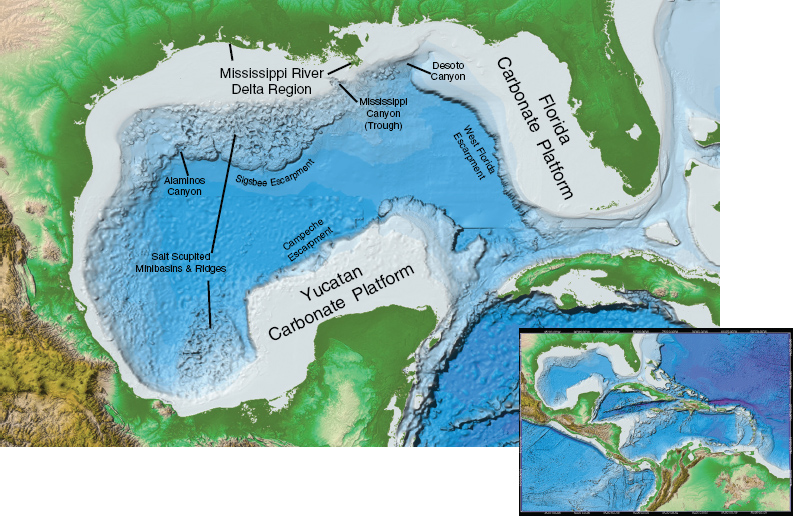

Right at the time of the Triassic-Jurassic extinction event. The start of this splitting apart would have been seen large volcanoes which probably contributed to the extinction event.
What happens is that a new ocean starts out a simple rift valley with volcanoes. As the rift continues splitting apart, the middle gets deeper and eventually gets flooded by the ocean. But it continues getting deeper and deeper and the ocean bottom literally sinks into the mantle and it gets deeper.
The old ocean of 200 million years or more, is the deep, deep ocean which the Gulf of Mexico still shows.
And how it started 200 million years ago as a small flooded rift valley as Pangea started to split up and the Atlantic ocean was literally born right here is this small part of this image.
Here you can see that the Black Sea and the Caspian Sea are also remnants from the Pangea time when they were old ocean in the Paleo-Thethys sea.
http://img-fotki.yandex.ru/get/4312/invngn.6/0_2f89b_c17aa701_XL
https://geosciencebigpicture.com/2013/01/06/seafloor-isochrons-place-a-hard-limit-on-crustal-disintegration-from-the-chicxulub-impact/
Indeed, some pretty old ocean floor in the Gulf.
There are impact implicated salt diapirs on the Colorado Plateau. Some may have involved Jurassic evaporates.
Ejecta indicate the Chicxulub impact was oblique.
Thanks! Glad to see that the US government doesn’t waste every single tax dollar. I like bathymetry. I’ve used high-res charts to imagine the English Channel landscape during the LGM.
When you consider where the K/T extinction bolide hit, and that the Siberian Traps eruptions caused thousands of square miles of coal to burn, it’s hard not to conclude that a vengeful or just sadistic God wanted to wipe out life on earth repeatedly, not just in the mythical Flood.
When Murchison discovered the Permian in Russia, then other geologists compared its fossils with those of the Early Triassic in the 1840s, the best hypothesis they could come up with for recovery from the mass extinction event was a whole new creation.
Today it’s called the Triassic Explosion, because it so resembles the turnover following the Ediacaran MEE, ie the so-called Cambrian Explosion.
Finds of Neanderthal remains on the Channel Islands suggest that these high points were used as lookout positions to find herds of migratory megafauna on the plain below, ie the present seafloor of the Channel.
The Deccan Traps was the flood basalt event associated with the K-T extinction. The Siberian Traps was associated with the end Permian extinction.
I know. That’s why I said God must hate us. He tried twice to wipe us out geologically, at the Permian and Cretaceous extinctions. To which could be added the Triassic-Jurassic, caused by the CAMP eruptions.
Guess I should have mentioned the Permian rather than relying on people’s geologic knowledge.
We weren’t around back then… So far, God has generally spared humans from the effects of a major flood basalt event. So, barring Tony Stark inventing an Ultron, God may not hate us quite that much… 😎
The Deccan Traps didn’t erupt into coal seams, obviously, since they were caused by the Indian Plate traveling over the Reunion Island hotspot, and the Indian Plate lacked extensive coal beds.
It was still a massive flood basalt event and may have been enough to trigger a mass extinction without the help of the Chicxulub impact.
David,
IMO the Deccan Traps couldn’t have triggered a mass extinction event on their own. Maybe some extinctions, but it’s hard for me to see how they could have wiped out so many different organisms on land, in the seas and air, in such an apparently short period of time.
Below the iridium layer, abundant life typical of the Mesozoic Era. Above it, first nothing but a fern spike, then organisms ancestral to Cenozoic life.
The pattern is more prolonged for the end Paleozoic extinctions, although still quite short.
The Deccan Traps may not have totally wiped out the dinosaurs without a massive impact event; but it clearly was on the mass extinction scale…
IMO only because it happened roughly to coincide with the impact. On its own, it wouldn’t have been a pimple on the posterior of the CAMP.
Flood basalt events are really bad. They are generally associated with large igneous provinces… So, even when they are just “pimples,” they are very nasty and very large (YUGE) pimples.
Oceanic crust production was in overdrive during the Cretaceous, the Deccan Traps was immediately followed by the emplacement of the North Atlantic Large Igneous Province (back-to-back flood basalt events)… toss in a massive impact event striking a thick sulfur-rich evaporite sequence… and you have mass extinction over-kill on steroids.
As you say, the North Atlantic LIP was also extremely large and only about 10 million years after Deccan…but no extinction, not even a minor one. To the contrary there was a remarkable evolutionary “explosion” at the time.
There is however an interesting theory that the seismic energy from Chicxulub may have triggered a brief but very extreme eruption of the Deccan hot spot:
http://pages.uoregon.edu/leif/GSAB_2015_Richards.pdf
https://arxiv.org/ftp/arxiv/papers/1701/1701.04704.pdf
In the immediate aftermath (geologically speaking) of the K-T extinction, the genera capable of surviving the Deccan Traps and Chicxulub impact, survived the formation of the North Atlantic Igneous Province.
The NAIP may have helped trigger the PETM.
Usually it isn’t possible to see salt tectonics actually in action since salt near the surface is rapidly dissolved by ground water. However in the Arava rift in Israel/Jordania the ancestral Dead Sea has been building a fairly large salt deposit since the Neogene. This is now thick enough for diapirism and the extremely arid climate means that salt dissolution is quite slow. The result is that there is a salt dome on the SW side of the Dead Sea that has grown into a sizeable mountain (Mount Sedom). It is an utterly fascinating area with, among other things, halokarst caves, I e dissolution caves in salt caused by the same mechanisms that causes dissolution caves in limestone in wetter climates. There are even salt stalaktites/stalagmites!
If you are interested in geology don’t miss this place if you ever visit the Dead Sea
Wow, something actually interesting from a USG agency. Bet their supervisors will be punishing them for releasing this!
Thanks, David, for an exceptionally interesting post — and for the shout-out to “The Prize Beneath the Salt”, an excellent and well-illustrated review paper.
And thanks to the commenters for the interesting and civil followup discussion. A win-win. Nice!
The second coolest thing about halokinesis (salt tectonics) is that it is a subject which totally obviates polirics. The coolest thing about halokinesis is interpreting 3d seismic data in salt basins… 🖒🖒