UPDATE: Drone video over spillway added.
Collapse of emergency spillway expected, evacuation ordered

Department of Water Resources officials say they expect the emergency spillway at Oroville Dam to fail, and say residents should evacuate northward.
The emergency spillway suffered erosion and could fail, according to DWR. If that happens, the water behind that barrier will comedown the hill and down the river.
Flow through the broken main spillway was increased to 100,000 cubic feet per second in an effort to lower the water level in the lake more rapidly.
The Butte County Sheriff’s Office reports helicopters will be depositing rock-filled containers to strengthen the potential failure point.
Bud Englund, a public information officer for the incident, said downtown Oroville and low-lying areas, including residents along the Feather River from Oroville to Gridley, are being evacuated.
Reporter Andre Byik said Caltrans and the California Highway Patrol have converted the southbound lanes of Highway 70 into northbound lanes to expedite the evacuation. Traffic there is still nearly gridlocked.
An evacuation center has been set up at the Silver Dollar Fairgrounds in Chico. Black Butte Lake west of Orland has also opened up the Buckhorn Campground to evacuees.
Emergency operations centers as far south of Sacramento have been notified, Englund said.
Evacuation orders have also been made in Yuba and Sutter counties.
From ChicoER.com
My local newspaper publishes a scathing editorial of DWR idiocy and mismanagement
Live video here: https://www.facebook.com/KCRA3/videos/10155026580966514/
UPDATE: DWR issued this statement.n their track record so far…not sure its all that reassuring.

OROVILLE DAM, Calif. – The Department of Water Resources has provided an explanation as to why the mandatory immediate evacuations in Oroville and areas downstream are occurring. The concern is that erosion at the head of the emergency/auxiliary spillway issued evacuation orders for residents. The concern is that erosion at the head of the emergency spillway threatens to undermine the concrete weir and allow large, uncontrolled releases of water from Lake Oroville. Those potential flows could exceed the capacity of downstream channels.
To avert more erosion at the top of the emergency/auxiliary spillway, DWR doubled the flow down its main spillway from 55,000 cubic feet per second (CFS) to 100,000 cfs. The next several hours will be crucial in determining whether the concrete structure at the head of the auxiliary spillway remains intact and prevents larger, uncontrolled flows.
Current flows are contained with downstream channels.
Flow over the auxiliary spillway weir began Saturday morning and has slowed considerably. DWR officials expect that flow to stop entirely soon, according to a press release sent at 6:11 P.M. Sunday. This would reduce the erosion on the downstream side of the structure.
DWR officials stress that Oroville Dam itself is sound and is a separate structure from the emergency/auxiliary spillway.
Source: http://www.water.ca.gov/news/newsreleases/2017/021217-pm_release_oroville_evacuation.pdf
UPDATE: Live view from the State Emergency Operations Center
UPDATE: Drne video shot earlier today:
What’s the long-term future of this dam now that the emergency spillway is eroding and the main spillway is destroyed.
Well, it ceases to be a dam now. You can’t hold back and release water to maintain a reservoir level. You can only keep releasing water to keep the reservoir below the main spillway level. It needs $400 million of repairs which can only be undertaken in dry conditions and will take at least 5 years.
The power station will have the only release capability and that will be limited.
In other words, the majority of the reservoir water is coming downstream. Cities and farmland in the way are going to be gone in the five months it takes. Then there will be at least 5 years of more disasters until a real spillway is replaced. Maybe it won’t be fixed. Then you have a big dam holding back a little bit of water and an operating power station, that’s it.
You can at least buy 200 windmills for that money.
You cannot drink from a windmill.
You probably shouldn’t drink from a hydro-electric out-flow either.
Some temporary repairs can be made to keep the main spillway from collapse and then begin the real replacement of the main spillway when the inevitable drought kicks back in 2 to 3 years from now. First they have to drop the lake level far enough to safely close the gates and survey the extent of the damage to the main spillway, then they will likely place some sort of rock fill in the current hole on the main spillway to try to prevent eroding away more soil until it is dry enough for a more substantial repair. Once it is dry again, they really need to replace the whole spillway with something that can take the pounding.
The emergency spillway is another problem altogether and will need a complete redesign and construction to prevent erosion anywhere near the dam front. This is going to be expensive but that is really their only option.
When planning this they need to remember that California may go long periods with little rain, but when they do get rain, it comes down in torrents and has been that way for a very long time. 5-10 fairly dry years marked with extensive brush fires followed by floods for a year marked with mudslides and avalanches.
In my opinion they will keep the main spillway gates fully open until the water is low enough that it cannot go over. While they are waiting for the water to stop in the main spill way they will have to shore up the emergency spillway as much as possible.
When water flow stops over the main they will have to fill the holes with rock and than poor cement over it and replace the missing walls. This is only a patch to allow the main spillway to be used in a more normal manner.
Longer term part of the emergency spillway should be replace with a new Main Spillway of equal size to the first. Them at that time the old main spillway and patch can be removed and replaced with a new one capable of maintaining its shape without failing even if the soil settles under it. Then the emergency spillway will be take susstained use without fail.
In the end you would wind up wiith 2 spillways each of which is capable of handling most floods by itself. If the rare really wet year like this one both spillways would be able to handle the flow without using the emergency. And if the emergency is needed it will not fail. Of coarse in the worst case situation you would still have some flooding downstream.
Why, if they’re worried about erosion, was there a mass clearance of vegetation?
No doubt we are witnessing the event that will create our first climate refugees.
No, we are just witnessing the most recent refugees created by government incompetence.
The Butte County Sheriff’s Office reports helicopters will be depositing rock-filled containers to strengthen the potential failure point.
For some reason that reminds me of USSR helicopters dropping sand, lead, clay and boron on to the smoking wreck of the Chernobyl reactor.
You got a hammer, everything looks like a nail.
As a civil engineer watching from afar, I have a couple of observations. The Oroville Dam is actually two different structures, the dam itself and the control structures, separated by part of a large hill. Rule of Thumb No. 1: Hills tend to be solid rock covered by soil. The thickness of the soil tends to be less on steeper slopes and the top. While the soil may wash off the hill, the rock isn’t going anywhere. Therefore, it is unlikely that the dam itself will fail. The dam would fail if it is over-topped by water. The crest of the dam is at 920 and the crest of the emergency spillway is 901 so there would need to be 19 feet of water going over the emergency spillway before the dam is over-topped.
The main spillway appears to be sitting on the rock. It can be seen in pictures when the water is down that this spillway sits in an excavated trench. The large wall on the right side of this spillway is probably solid rock. In a worse case scenario, the entire main spillway would wash away but the erosion would not go any further down.
I have no idea what is going on with the emergency spillway. I would have thought that it would also be sitting on rock. It’s at the top of the hill, and the soil shouldn’t be that deep. That being said, when I saw the closeups of the bottom of the emergency spillway on Saturday I wondered about the lack of rip rap or concrete at the bottom of the wall. If it is founded on rock it would be hard to undermine, but the latest pictures seem to show that undermining is a possibility. If the emergency spillway fails it will erode until it hits rock which should be no lower than the bottom of the main spillway.
The problem at the main spillway appears to be that water under the slab had washed away part of the base material over the years. Rule of Thumb No. 2. Civil engineers have very poor x-ray vision. And it is far worse than other people think it is. I know mine never worked at all when I tried to see through concrete. Sometimes we can guess better than other folks what is under a concrete slab, but that is only because of experience. You can improve your guessing by drilling holes in the slab, but if the hole is 6 inches away from a void, you still don’t know if the void is there. So how many holes should you drill in the main spillway looking for voids? 100? 200? 1,000? Its a BIG slab. The void may only be an inch high. I can see how they might miss the problem. Of course you could always tear out portions of the slab to check. The problem with this is that it is tough to make the new slab as good as what you tore out. Tying the old and the new together isn’t easy.
As to why they didn’t release more water out of the main spillway, I would guess they were trying to limit the damage. Obviously they were damaging the main spillway. Plus they were worried about washing away some of the power line towers. And all the debris washing off the hillside was ending up in the river. This causes a dam in the river which raises the water upstream. As the water backs up it effects the powerhouse. Is it possible that the powerhouse could be flooded? I don’t know, but think what that would cost. In any case, all the debris in the river will need to be removed before the powerhouse can be used again. And who’s going to pay for all that damage? The taxpayers. So the folks in control of the dam are in a tough spot. They want to reduce the cost of repairs and they also don’t want to cause floods (or evacuations) downstream. They have limited choices, and the choices change as conditions change.
So how many holes should you drill in the main spillway looking for voids? 100? 200? 1,000? Its a BIG slab. I wonder if geophysics could help. High frequency Seismic Acoustic reflection to find where the concrete is not in contact with the soil/rock. Gravity Gradient measurements could find large voids quickly, and having a smooth, if not flat, concrete surface simplifies the processing.
So how many holes should you drill in the main spillway looking for voids? 100? 200? 1,000? Its a BIG slab.
I wonder if geophysical tools could help. High frequency seismic acoustic reflection could find where the concrete is not in contact with the soil/rock. Gravity Gradient measurements could find large voids quickly, and having a smooth, if not flat, concrete surface simplifies the processing.
I have nightmares, but nothing like this.
The problem with the emergency spillway is like this. … the emergency spillway is a section of the rim of the dam between the mountain and the spillway. The top of this section is lower than the dam’s rim. But it also runs that way for some distance.
The problem is that the ES started seriously eroding back towards the concrete rim as water actually flowed over it. This creates the very real chance of the concrete rim suddenly crumpling and in turn abruptly dropping the top 50 + feet of lake down the ES.
This is the emergency they are evacuating everyone for.
I have only now had a good look at this. I do not believe that there was a void.
The problem was water trapped under the slab. The material under the slab was water saturated.
If you look closely at the videos and pictures of the main raceway one can see that there are flows of water coming out of the side wall drains.
For this water to be present the underside of the raceway would have to be flooded and the flooding would be lifting the floor like the bottom of a boat. I have seen several viaducts lost this way.
When the + 50K cfs of water ran over the bottom the hydraulic lift lifted a slab up far enough for the lip to be caught by the flow and,,, big bada boom.
Just out of curiosity, how much power is represented by 100,000 cuft/sec of water falling 900 ft (the height of the dam, I believe)
Quick SWAG – 700 MW (a good sized coal plant).
a small nuke
901 feet seems to be the height above sea level of the crest of the emergency spillway (so maximum water level).
The dam is 770feet high, the head at the power station is 615feet and the power station is rated 819MW, annual production 1490GWh [Wiki but the references seem OK and also (1490 x 1000) / (819 x 24 x 365) = 0.21 which seems plausible too]
I trust Jerry will be diverting some of his Satellite program money to his infrastructure budget.
That’s going to be a problem. They will need the money to fight the Trump administration and support illegals flooding to the Sanctuary State of California.
So you are telling me that Trump is actually going to build a ‘flood control’ wall?
Jimmy-Jimmy
I would not be the ranch on that assumption.
I still do not understand why they thought releasing 65k cfs over the regular spillway would mitigate the 130k cfs that was entering the lake.
“I still do not understand why they thought releasing 65k cfs over the regular spillway would mitigate the 130k cfs that was entering the lake.”
WR: The regular spillway was broken. Erosion under the remaining concrete and aside of it may / will result in what is called ‘backward erosion’. A rising quantity of water will bring (more) backward erosion and so more damage of the spillway upwards to the dam. This might end in damaging the dam itself and/or its fundaments. That is a high risk. Therefore there was the ‘try out’ of the emergency spillway. But if failed.
I saw on pictures (see: the three red circles on the video image of AndyG55 February 13, 2017 at 12:36 am) that left of the emergency spillway (there where the now drowned parking place was) there must be something like a ‘dike’ and on several places this ‘dike’ showed to be very permeable: water streams came out on the valley side. Erosion here would very soon create a river flow down on this very unexpected place. Very soon this ‘third flow’ would lower this [possibly] not enforced area below the height of the enforced emergency spillway and this would result in an uncontrolled outflow of the lake. I suppose.
That permeability could be caused by the droughts of years. In Holland some years ago a dike broke after a long summer drought because the material of the dike became to dry and became too permeable. This could have happened here also. (Right now in Holland they are improving all comparable dikes)
Thanks Wim Röst, however my question was not about why they were limiting the discharge in the regular spill way, but why they thought the laws of mathematics would change because of the damaged spillway. It was mostly a rhetorical question, as someone either was totally incompetent to make such a statement about “not needing to use the Emergency Spillway”, or they were lying to the public.
The spillway at the Oroville Dam fails. Blame Climate Change, not the politicians. A Limerick.
The spillway at Oroville Dam:
The “permanent drought” was a scam.
“No more need for repairs,
if it fails, no one cares.”
“It’s Climate Change. Blame Uncle Sam.” https://lenbilen.com/2017/02/13/the-spillway-at-the-oroville-dam-fails-blame-climate-change-not-the-politicians-a-limerick/
No – water is not going under the main dam. The water level is too high on the backside of the dam (due to the large flows from the spillways) to safely operate those chutes.
Here’s what I think. Round up all the Hollywood blow hards who have been screaming in our ears about climate/Trump/bans whatever instead of just accepting their awards with gratitude then getting off the damn stage. Pass out shovels, and put THEM to work fixing this. Maybe then they will stfu about drought.
Then whom would produce the movies that draw us out to the movie theatres every weekend ?
Quite right, Pamela. Last night on the BAFTAa (UK TV) the winning screenwriter got up accept his award and, like everyone else dump on Trump. He said that on the morning after the election his 15 year-old daughter pleaded not to go to school as she was so frightened. He persuaded her to go so she could provide comfort to all her classmates. He then went in to say how proud he was of her because she had since been on FIVE protest marches.
Pass the sick bag.
Good to know. I had suspected that the same faces were showing up at the various marches for [insert cause here] week after week. 😉
They are using that face-recognition technology to log all those march participants, aren’t they?
That could be the basis of a great disaster flick. Hollywood’s best trying to save the town of Oroville by placing them selves in harm’s way. Will the weir collapse washing all of them away? Stay tuned for Episode II titled “Run Away, Run Away!!!!!
Previous inhabitants of Hollywood managed to get “their” reservoir permanently lowered till 1/2 or 1/3 capacity after the 1928 St.Francis dam collapse near L.A.
Let us forget for a minute the daily oddities and the hogwash of politicians and let us pray for those who are about to lose their property or even life and limb.
Oh God, please give Californians a wisdom not to elect fools.
The difficult job of spillway repair will be done today.
The impossible will take a little longer.
British TV is reporting they are dropping (or going to) rocks into the breach, wouldn’t the sand bags (if sand is available) be more effective ?
Vukcevic: “wouldn’t the sand bags (if sand is available) be more effective ?”
WR: depends on the place: on the top of a dike some sand bags are OK. But where a lot of water is flowing big rocks are more appropriate. To dam sandy sea arms with strong tides In Holland they used concrete blocks of 2,5 tons, around one cubic metre each.
Not with water moving that fast. They will need the biggest rocks they can get. Later they should add finer fractions (smaller rocks) to fill the voids between the larger rocks, but after the larger rocks can keep the smaller ones from being washed away.
The obvious solution: award the contract to update our dams and waterways and to provide more water storage to Dianne Feinstein’s husband. It will cost 100% more than it should, he will get much richer, but hey, it will eventually get done. He’s working hard making big money on the bullet train to no where. Over budget and behind schedule…..
Now look what’s happened ..
http://www.mercurynews.com/2017/02/12/oroville-dam-feds-and-state-officials-ignored-warnings-12-years-ago/
And they also ignored the catastrophic flooding after drought-shy dam operators in Australia were tardy in spilling the excess from the lake behind their dam.
Haven’t heard anything on this, but has California contacted the federal government (Trump administration) for assistance? From my FEMA on-line training, the federal government doesn’t volunteer assistance in these instances — the governor has to request it.
CA already has one request in — maybe 2 — for issues prior to this one. So it seems the State and Fed officials can just add another line to the meeting agenda.
This may be a long shot but desperate times…
I suggest plucking non-functional wind turbines out of the ground and dropping them in the hole. Rip rap and fish habitat may be the highest and best uses for these vista-marring eco-altars at this point in time.
On a more serious note, thoughts and prayers to all that a crisis may somehow be averted.
Of course you can’t be exposing downstream communities to such things, because:
“ “This product contains a chemical known to the State of California to cause cancer, birth defects, or other reproductive harm.”“
I believe I saw that warning on the side of a bottle of water once…something about the dangers of dihydrogen monoxide causing cancer in lab rats when force fed their body weights every hour.
What happens if a dam fails that is relied on for cooling water at a nuke plant?
As some have suggested, part of the problem is the focus CAGW diverts from more important issues. We live in a world of limited resources.
For example, there is a significant daily risk of smoke inhalation. Do your smoke detectors work? How do you know? Do you have a plan when they go off?
Most of the things to reduce significant risk require very little resources but are often overlooked because they are mundane. Test your smoke detectors, look both ways when crossing the street.
I was responsible for decay heat removal at Rancho Seco. The normal supply of makeup water for evaporative cooling was an irrigation canal from Folsom Dam. There was a 30 day supply in a small lake we had but after that we would need pumper trucks to bring in water.
I considered how reasonable it would be to get water by truck if Folsom Dam failed. Off course all the bodies of the journalists at the Sacramento Bee would have been washed under the Golden Gate Bridge by then.
This becomes a question to be answered by philosophers. If there are no fear mongering journalists, is there any fear?
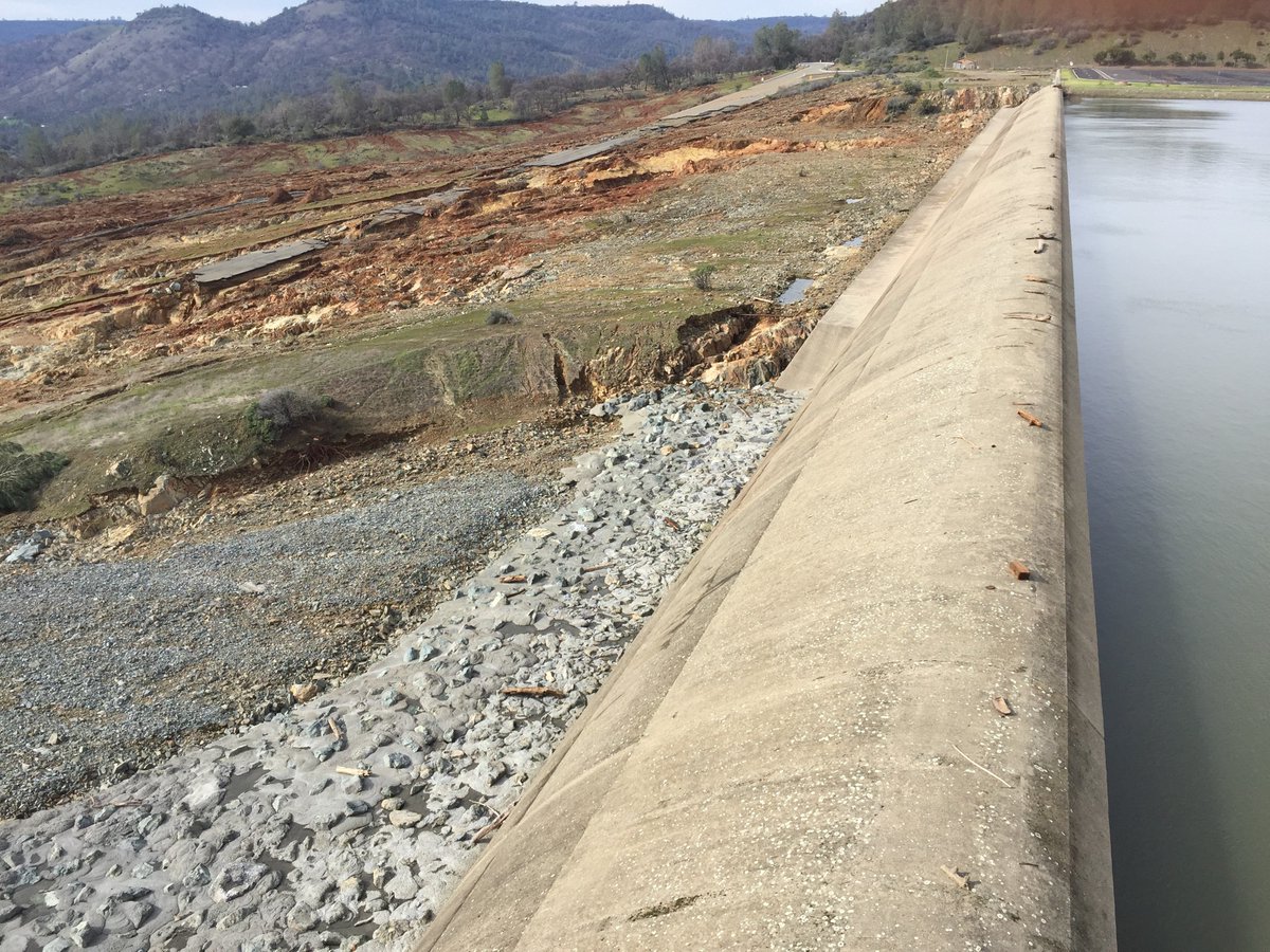
Looking at the erosion on the emergency spillway this morning from the news helicopters, it can never be used again
Maybe with thousands of tons of concrete poured everywhere but that is it. Significant erosion channels and one is just 20 feet from undermining the emergency spillway wall.
So, the reservoir just has to be released through the main spillway until it is very low (and it has to be that way until a new spillway is built).
That erosion of the emergency spillway is natural and expected. It will not affect its subsequent use.
This pic of one of the erosion channels shows that the emergency spillway was minutes/hours from being undermined and that would have been it. 20 or 30 feet away only and 40 feet deep.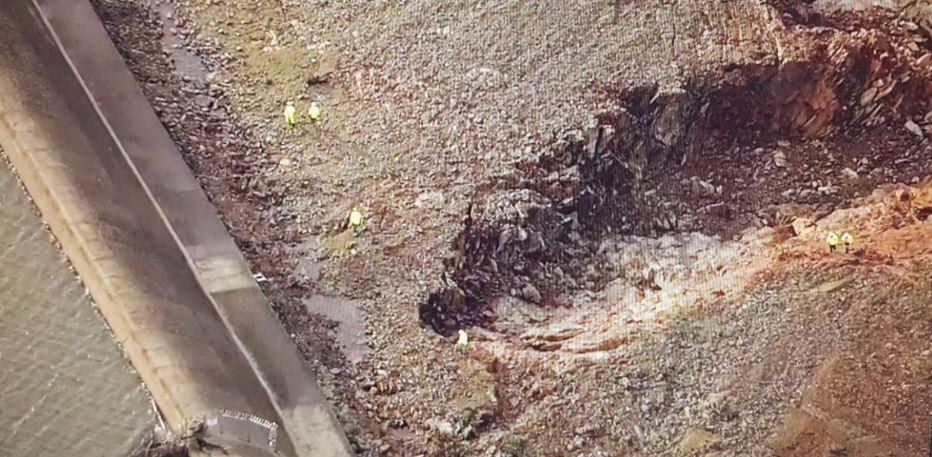
They cannot use it again until there are hundreds of tons of concrete poured over this spot and where ever else needs it. Just say they can never use this spillway again because it will fail.
False. What is usually done after an emergency spillway is used & eroded like that is nothing. No repairs are necessary to the emergency spillway, it is expected that the soils will erode. The road will be rebuilt, but that is expected as well.
Earlier, I had posted a pic of a guy holding a cement boom and pouring concrete over a boulder field on the emergency spillway floor next to the main spillway.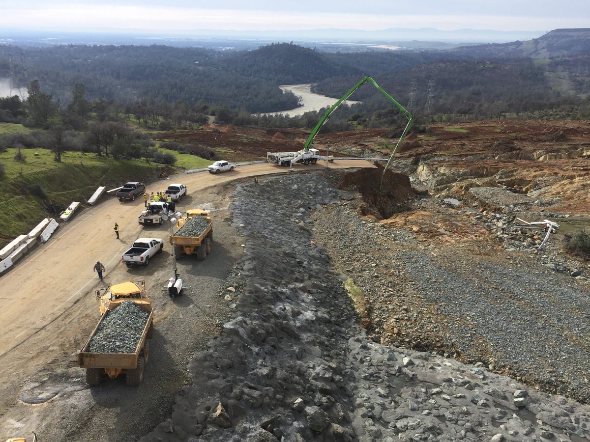
Well this concreted boulder field held up extremely well and it looks like that is the way forward to protect against further erosion if the spillway is needed again. So they are back at it.
Another view of the concreted boulder field and the other erosion channels.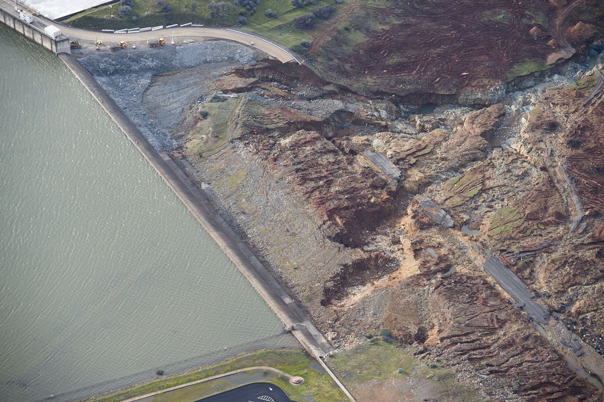
Another view …
Every good Eco-Lib knows all dams are bad things. If this dam had never been built, this would never had happened. This is just Gaia trying to reclaim nature. When this is over, I’ll bet the Eco-nuts will demand the dam be demolished. You heard it here first.
Should the foundation of the emergency spillway be fill of any kind then game over for that option. They have to pray for no more cloudbursts, then drain the reservoir to provide a window for repairs of the main spillway. Dropping any rock within the lift capacity of any helicopter is not going to do it. I have stood beside a steep inclining river in full flood. The rumble of 3 ton boulders being rolled downstream was deafening. This spillway is much steeper. One option could be to pour synthetic reinforced concrete directly into the damaged portion of the main spillway by air. There is for sure some sleepless nights over there.
It is in the politician’s interests and engineer’s interests to claim that this is an extreme event that could not be anticipated. We all know where that leads to.
The designers would have known that. Which is why they chose this site for the emergency spillway: It has rock underneath to support the structure. They would have tied the weir into that rock.
Interesting pic of the emergency spillway close up. Click and click to zoom.
https://www.flickr.com/photos/sirerichenbauch/8140651480/in/photostream/
Of course it can be blamed on current Federal Administration. Instead of messing around looking for a few bad hombres they could be devoting funds to critical infrastructure that has capacity to kill 100,000 in minutes. Lack of Judgement! Hold Ryan and Mitch personally liable!
Oroville dam has been studied for “confirmation of the design”
http://dean.marachi.com/bio_ed.html
Dr. Marachi’s doctoral research, then under the tutelage of the late Professor H. Bolton Seed, involved a comprehensive study of strength and deformation properties of rockfill material. This research, estimated at $20M, was financed through grants from California DWR, National Science Foundation, USBR and a number of other agencies. It included design of highly elaborate testing equipment, instrumentation, and laboratory testing of actual and modeled rockfill material. Results of his pioneering research have been used for confirmation of the design of Oroville and Pyramid dams in California, El Infernilo dam in Mexico, and Tarbella dam in Pakistan, which are all built and working satisfactorily. It is also published and/or referred to by most text books in geotechnical engineering as well as the U.S. Bureau of Reclamation design manual for dams.
Steve Oregon
Unclear what the point of your post is. Clearly the design one the “emergency overflow” was/is deficient. Doesn’t matter what Dr. Marachi’s $20M doctoral research & models showed.
I was just pointing out that the Dam itself appears to a good design and in good shape.
Look, they worried about a failure of the emergency spillway.
If in fact it has been undermined, it is just a matter of time, unless they lower lake levels by about 30 feet.