Guest Post by Bob Tisdale
Sad to say, I suspect it may reemerge at the surface…maybe not as strong as in the past, but I don’t think it’s going to disappear completely in 2016. I hope my suspicions are wrong, though.
NOTE: This post includes two gif animations so it may take a while to load on your browser.
INTRODUCTION (BOILERPLATE)
We first discussed an unusual hotspot in the sea surface temperature anomalies of the eastern extratropical North Pacific two and a half years ago in the August 2013 post appropriately titled About the Unusual Warming Event in the Extratropical North Pacific Sea Surface Temperature Anomalies. That large pocket of elevated sea surface temperatures was later given the nickname “The Blob” by Nick Bond of JISAO. Since that first post, we’ve discussed it numerous times, along with its impacts on global surface temperatures:
- The Hotspot in the North Pacific (February 2014)
- On The Recent Record-High Global Sea Surface Temperatures – The Wheres and Whys (August 2014)
- Axel Timmermann and Kevin Trenberth Highlight the Importance of Natural Variability in Global Warming… (November 2014)
- Researchers Find Northeast Pacific Surface Warming (1900-2012) Caused By Changes in Atmospheric Circulation, NOT Manmade Forcings (December 2014)
- Did ENSO and the “Monster” Kelvin Wave Contribute to the Record High Global Sea Surface Temperatures in 2014? (December 2014)
- Alarmists Bizarrely Claim “Just what AGW predicts” about the Record High Global Sea Surface Temperatures in 2014 (January 2015)
- North Pacific Update: The Blob’s Strengthening Suggests It’s Not Ready to Depart (April 2015)
- August 2015 Update for The Blob
WHAT CAUSED THE BLOB? (BOILERPLATE)
According to Bond et al. (2015) Causes and impacts of the 2014 warm anomaly in the NE Pacific, a persistent ridge of high pressure in the mid-to-high latitudes of the eastern North Pacific (known as the Ridiculously Resilient Ridge) prevented the sea surfaces there from cooling normally. The Ridiculously Resilient Ridge is also responsible for the high temperatures and drought conditions along the west coast of the U.S. in recent years. See Anthony Watts’s April 2015 post “Warm blob” in Pacific Ocean not caused by climate change, affects U.S. weather at WattsUpWithThat. It includes the press release for two papers: Bond et al. (2015) Causes and Impacts of the 2014 Warm Anomaly in the NE Pacific and Hartmann (2015) Pacific sea surface temperature and the winter of 2014.
HOWEVER
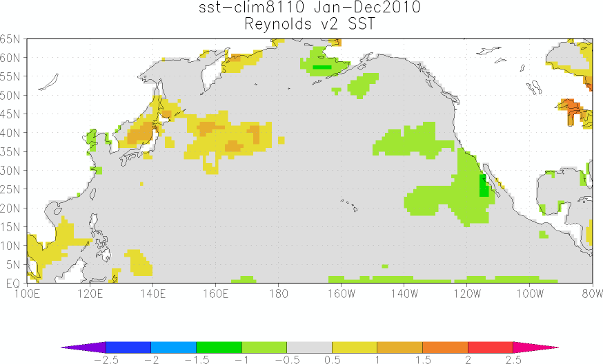
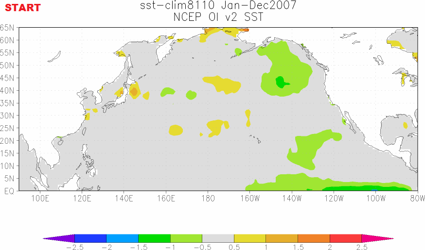
Let’s examine the animation of sea surface temperature anomalies for the North Pacific, starting in 2007. Animation 1 is an update and expansion of the animation here from the post North Pacific Update: The Blob’s Strengthening Suggests It’s Not Ready to Depart. (My thanks to blogger Bill Illis for suggesting I extend the animation back in time.)
Animation 1 (You may need to click start it.)
Animations of maps of monthly and weekly sea surface temperature anomalies can be very volatile, with weather effects and seasonal components creating a lot of visual noise. To minimize the monthly volatility and seasonal components, each of the maps in Animation 1 presents the average sea surface temperature anomalies for a full year. The annual maps then advance on a monthly basis. That is, the first map covers the 12-month period of January 2007 to December 2007. The second map is for February 2007 to January 2008. The third map: March 2007 to February 2008. And so on through the last map for January 2015 to December 2015. This is similar to smoothing time-series data with a 12-month running-mean filter. I’ve paused the animation and added notes of the timing of El Niño and La Niña events.
We can see that the warm water for The Blob appears to form during the 2010/11 La Niña and that it is then enhanced during the 2011/12 La Niña. That suggests a couple of things: (1) The warm water for The Blob may have first been released by the 2009/10 El Niño and then spun up east of Japan into the Kuroshio-Oyashio Extension (KOE) during the trailing 2010/11 La Niña. Or (2) changes in atmospheric circulation caused by the 2010/11 La Niña caused the warm surface waters to build up along the KOE, which was then enhanced during the 2011/12 La Niña.
When did it that warm pocket of water couple with the ridge of high pressure ? Dunno.
We can also see another Blob-like pocket of warm surface waters forming during what used to be called the 2008/09 La Niña…before NOAA switched to the ERSST.v4 “pause-buster” sea surface temperature data. Maybe a prerequisite for The Blob is a double-dip La Niña…but with a moderately strong El Niño preceding it.
THE BLOB APPEARS TO BE DISAPPEARING AT THE SURFACE
Let’s look at another animation. We can see The Blob in the eastern extratropical North Pacific appearing to be dissipate in recent months.

Animation 2 (You may need to click start it.)
For Animation 2, I’ve borrowed and annotated the maps from Saturday’s 52-week animation of sea surface temperature anomalies from the NOAA ESRL PSD Map Room Climate Products – Sea Surface Temperature (SST) website, specifically the webpage here. I’ve noted on the first frame the location and coordinates that NOAA uses for The Blob in their GODAS Monthly Ocean Briefing.
We can see that the focus of The Blob shifts location and that it seems to strengthen and weaken over 2015…and that it appears to be dissipating/disappearing in recent weeks.
WHY WOULD THE BLOB REEMERGE AT THE SURFACE?
Mother Nature has once again shown that she can cause ocean heat uptake to depth. That is, The Blob, a naturally occurring event, created a lot of warm water to depth in that location. We can still see evidence of this in the most recent NOAA GODAS depth-averaged temperature reanalysis for the depths of 300 meters (a.k.a. T300 anomalies). See Figure 1. (Map available here.)

Figure 1
An even better illustration: Figure 2 is page 25 from the NOAA/GODAS Monthly Ocean Briefing. It includes two Hovmoller diagrams in the upper left-hand side that show the temperature anomalies to depths of 300 meters: one from 1979 to present and the other for the past 4 years. The temperature scale is difficult to read, but I believe the numbers range from -1.8 deg C to +1.8 deg C.

Figure 2 (Page 25 from NOAA/GODAS Monthly Ocean Briefing)
Even though surface temperatures in The Blob region have dropped in recent months, there is still a chunk of warm water below the surface…and it should eventually reemerge at the surface.
The third note on page 25 from the GODAS Monthly Ocean Briefing reads:
The development of the enhanced warming in late 2013 seems associated with the switch to positive PDO phase.
But the “enhanced warming in late 2013” precedes the “switch to positive PDO phase”, which didn’t occur until early 2014. In that case, wouldn’t it be clearer if it were written as, The switch to positive PDO phase seems to be a lagged response to the enhanced warming of The Blob in late 2013?
A COUPLE OF TIME-SERIES GRAPHS
I have switched to the coordinates used in the NOAA/GODAS Monthly Ocean Briefing for The Blob, which are 40N-50N, 150W-130W. I had been using a larger region: 35N-55N, 150W-125W. The sea surface temperature anomalies of NOAA’s smaller region are a little more volatile than my former region. See Figure 3.

Figure 3
And Figure 4 includes the time-series and annual evolutions of the sea surface temperatures for the coordinates used by NOAA for The Blob. Based on the weekly maps shown in Animation 2, I suspect we’ll see an even further decline (an anomaly below 1.0 deg C) in the January 2016 sea surface temperature anomalies for that region. Check back here on the second Monday or Tuesday in February for the January 2016 sea surface temperature update. The Blob update is near the bottom. While you’re at it, please add my website to your favorites. The sea surface temperature updates are not cross-posted at WattsUpWithThat.

Figure 4
MODEL FORECASTS FOR THE BLOB
Figure 5 is page 38 from the latest NOAA/GODAS Monthly Ocean Briefing (with my highlight) for your info.

Figure 5 (Page 38 from NOAA/GODAS Monthly Ocean Briefing)
The second note is discussing the forecasts for the sea surface temperatures of the North Atlantic in response to the 2015/16 El Niño, which usually begins in the early part of the decay year of a strong El Niño.
FURTHER READING
For more information about The Blob, see the posts linked at the beginning of this post.
I also discussed and illustrated the blatantly obvious impacts of The Blob on 2014 and 2015 global sea surface temperatures in my free ebook On Global Warming and the Illusion of Control – Part 1 (25MB .pdf). See General Discussions 2 and 3. Simply click on those general discussions in the ebook’s Table of Contents. Of course, global sea surface temperatures in 2015 were also strongly impacted by the 2015/16 El Niño, as they will in 2016 with the lagged effects of the El Niño.
UPDATE: SOURCE
Oops. Forgot to state what sea surface temperature datasets were presented in Figures 3 and 4 and for Animation 1. It’s Reynolds OI.v2 sea surface temperature data from the KNMI Climate Explorer, where the maps for Animation 1 were created.
Thanks Bob for your hard and thorough work. Natural events are very complex.
When I look at the PDO cycle record during the down phase there has been in at least the last 2 cycles a midpoint El Nino of significant size. In fact this happened so significantly I could have predicted this El Nino. As a result I don’t believe that the “signal” of a return to positive phase PDO is justified unless there is some other data that i don’t know from previous PDO cycles to justify the end. How do we know the end of the cycle anyway? Is there some known event?
Would seem to me all these hot spots are submarine volcanism, especially for the Costa Rican trench over which El Ninos form.
A Pacific Blob!
When sailing from New Zealand to Norfolk Island ( some 40 years ago ) the engine temperature went up several degrees , after checking it was found that the seawater temp. was very high,, we decided to check, the high water temp. was about 15 km across, in the center you could smell sulfur, at a distance it showed as a bubble on the horizon, the water depth was as I remember about 3 miles.
This is a real observation that needs wider publication. Could you please publish (share) all factual details that you can reconstruct. We need name and positions of vessel, and accurate time. Thanks!
@ur momisugly Donald, Jan 24, 2:47 am, Thanks, I had the same thought but I looked more towards the area just east of Japan and actually that whole area. It is rife with plate tectonic movement ( both above and below the surface). Of course the march 2011 earthquake comes to mind . I wonder how much energy that put into the water? and remember the Kamchatka region all along their east coast they have a lot of active volcanoes as well. It is an interesting thought . ( Man we know so little)
By what mechanism could CO2 possibly cause this event? They always blame warming of CO2, but this phenomenon isn’t new, and it isn’t caused by CO2. For a field of “science” with a 95% consensus, there seems to be some pretty large unanswered questions.,
I have not seen the explanation for how CO2 gets the heat into the deep ocean. Frankly how Climate Scientists explain PDO/AMO? Obviously heat has to accumulate in the ocean so this has been happening for 100s of years. There is no proximate explanation that it could be from the sun or some biological activity? I don’t believe they understand how these El Ninos happen only that they see the result after the ocean has heated up but they don’t know how to model it heating up. You would think this is obvious and tf there were obvious reasons for it then these would be well known. NOT. Questions I would like answers to.
1) How did the heat from CO2 get to 300m depth?
2) Where does the heat for heating the El Nino come from, i.e. fundamentally (sun, volcano, deep water currents, biological or chemical cyclic behavior?? obviously its not CO2 as it happened before CO2 was ever put out by man.
3) Why is the cycle 60 years?
4) How much of the heating between 1975-2000 because of PDO positive phase vs CO2?
5) What is the basis for saying PDO down phase is over and is there historical evidence of that?
6) What would cause the end of a PDO phase in either direction?
7) Will PDO oscillation increase or decrease in magnitude because of CO2 or not be affected?
8) Will PDO end entirely because of CO2 dominance? When?
I asked the head of LLNL climate modeling these questions about 5 years ago. HIs answers:
1) Didn’t have any idea this was happening
2) No answer but El Ninos would go away over time as CO2 dominates
3) There is no cycle
4) NONE because PDO is gone. Doesn’t exist anymore.
5) NA
6) NA
7) decrease magnitude of PDO and El Ninos going to zero soon
8) Yes, already has
I would say his answers were wrong based on the facts emerged over the last 5 years and were pretty clear he was wrong then.
It does not have to be heating. all these animations are in anomaly mode.
Deep currents running to the pole will displace cooler water towards the equator no heating just a major anomaly lift and conversely deep currents sliding towards the equator also.
Its about absolute temperatures and total heat content. I read stuff from very clever people here but I suspect that this is beyond the instrument record and models so is left in the land of conjecture.
Good reading!
@Logic
From my understanding, the El Nino heated waters form from warm waters in the central and western Pacific, along the equator and occasionally the winds change over this area and push the warm waters, over time, to form up in the eastern pacific equatorial region. Sea levels off of equatorial south america actually rise significantly because of this.
“Where does the heat for heating the El Nino come from, i.e. fundamentally (sun, volcano, deep water currents, biological or chemical cyclic behavior?? obviously its not CO2 as it happened before CO2 was ever put out by man.”
===========================================================================
Gail Combs says:
January 25, 2016 at 9:53 am
…
In the three decades prior to the 2009 solar minimum and the switch to a ‘quiet sun (1979 to 2009) the amount of ultraviolet (UV) radiation reaching Earth’s surface increased markedly. This energy would be absorbed by the oceans at depths up to 100 meters.
FROM NASA:
NASA scientists analyzing 30 years of satellite data have found that the amount of ultraviolet (UV) radiation reaching Earth’s surface has increased markedly over the last three decades. Most of the increase has occurred in the mid-and-high latitudes, and there’s been little or no increase in tropical regions.
…..for example, …at one line of latitude — 32.5 degrees — a line that runs through central Texas in the northern hemisphere and the country of Uruguay in the southern hemisphere, 305 nanometer UV levels have gone up by some 6 percent on average since 1979. [This is addition energy into the oceans at that latitude]
The primary culprit: decreasing levels of stratospheric ozone….
The study also shows that increased cloudiness in the southern hemisphere over the 30-year period has impacted UV.
(wwwDOT)nasa.gov/topics/solarsystem/features/uv-exposure.html
Solar Radiation: Sources of Energy for the Earth’s Atmosphere
Solar Radiation – – – – – – – – – – – Energy Flux – Solar Cycle Change – Deposition Alt.
TSI (mostly Visible & Infrared) – 1366 W/m2 – 1.2 W/m2 – – 0.1% – Surface
MUV (200-300 nm).- – – – – – – – – – 15.4 W/m2 – 0.17 W/m2 – 1% – 15-50 km
FUV (126-200 nm) – – – – – – – – – – – 50 mW/m2 – 15 mW/m2 – 30% – 30-120 km
EUV (0-125 nm) – – – – – – – – – – – – -10 mW/m2 – 10 mW/m2 – 100% – 80-250 km
Ultraviolet light [and destroys] creates the ozone layer…
…. changes in the EUV irradiance affect the thermosphere, ionosphere, and near-Earth space.
(wwwDOT)nasa.gov/mission_pages/sdo/science/Solar%20Irradiance.html
…the solar-plus-ozone change leads to increased tropical stratospheric warming in the mid-to-upper stratosphere during solar maximum conditions. Higher latitudes during Southern Hemisphere winter receive no such augmentation, and the increased latitudinal temperature gradient results in stronger stratospheric west winds. Via the interaction of these wind changes and planetary waves propagating up from the troposphere, the circulation in the stratosphere weakens, a response characterized by greater relative upwelling in the Southern Hemisphere extratropics, and more downwelling in the northern extratropics. This downwelling has a tendency to extend into the troposphere, limiting convection and rainfall during Northern Hemisphere summer at these latitudes, producing drier conditions. This effect is seen in some paleoclimate records and has been attributed to solar influence.
Total solar irradiance changes, though of small magnitude, do appear to affect sea surface temperatures (SSTs), most obviously at latitudes where cloud cover is small and irradiance is abundant, such as the Northern Hemisphere subtropics during summer. The increased SSTs then help intensify circulations spiraling away from the subtropics, again favoring reduced rainfall near the equator and to the south, as well as northern mid-latitudes. Hence, both the UV and TSI forcings produce similar effects, with the latter helping to sharpen the response.
http://www.giss.nasa.gov/research/briefs/rind_03/
If you search Dr. Spencer’s weblog, he describes one mechanism and say that there are others which he doesn’t get into. One possibility, increased photosynthesis and biochemical sequestering of energy and release during decomposition.
Of course, the bio heat is SW not CO2 LW. There’d be CO2 warming offset by a decrease in SW warming.
Yet another educational post. Thanks Bob.
I would only like to point out the obvious — we know very little about the ocean. We have no real temperature records from the past. We don’t really know how the currents work all over the ocean and at all depths. We don’t even really know exactly how much solar radiation is absorbed at the surface and how the ocean contributes to those monster storms in the tropics that cool the surface there and move heat towards the poles.
Hades, we barely know anything about the ocean and its mechanics. Well other than the ocean is wet and salty I guess.
Can you imagine what we might know if all the money wasted on the CO2 delusion had gone towards understanding the oceans?
mark
I agree with every word you have written here.
I would add, again, that we mere humans have, generally, very little idea of the sheer size of the oceans.
I’ve bleated about this before – so won’t repeat.
Auto, comfortably inland at the moment.
mark 120% agree. This was the principal reason I had initial doubts about the science. Its well known the oceans have 1000 times the heat capacity of the atmosphere yet they claimed their results had 95% certainty, Obviously that is impossible.
@ur momisugly markstoval, Jan 24 3:31 am, + many I really appreciate Bob’s terrific work but as you say the amount of data covering our vast oceans is minimal especially when they seem to be even getting less and manipulated.
Simply an ENSO related typical characteristic.
Figure 1 (2016, Jan. 18) seems to present a (relative) movement of subsurface heat. Different in the Pacific for both the Northern and the Southern Hemisphere.
In the Southern Hemisphere just south of the Equator subsurface heat seems to be replaced from the western Pacific to the eastern Pacific. More southward it seems to be the reverse.
In the Northern Hemisphere [more] subsurface heat seems to be replaced from the southwestern Pacific (northern hemisphere) to both the eastern part and also (!) to the north of the Pacific.
Within the bigger oceans (Pacific, Atlantic) we see colder and warmer area’s. It’s not that one ocean is only warmer in it’s subsurface and another only cools down. Relative warmth (for a certain moment) seems to move within the boundaries of those big oceans.
Looking at the following animation of the Sea Surface Temperature Anomaly 2002 to 2015 the sequence of images gives me the feeling of ‘pulsations’ of relative surface temperatures within the oceans: https://svs.gsfc.nasa.gov/cgi-bin/details.cgi?aid=4413
I expect subsurface heat patterns to give the same kind of image.
I think those ‘pulsations’ are the bigger processes, expressed in ‘local’ patterns like El Nino/La Nina and ‘Blobs’.
It will be very interesting to get an image of world wide long term developments in those pulsations. Think about two ‘sixty year’ periods. Climate and ‘climate change’ require such a long term view.
As long as we don’t have these long-term patterns, year to year and more ‘regional’ patterns are the best we have. Your posts Bob are very interesting. I will keep on following them!
The blob seems to coincide with the northern Pacific gyre, maybe the layer of plastic particles and debris from the Japanese tsunami are insulating the surface the way a pool blanket keeps a pool warmer. Or perhaps because surface evaporation is inhibited.
I would think the persistent low pressure system sitting near the Aleutian Islands this winter would have something to do with dissipating the heat. Lots of colder air and wind.
For Figure 5, anytime CFSv2 is mentioned to predict anything, I just tune it out. It has trouble predicting if the Sun will rise in the morning.
The “Record SST Warming” reference in Figure 2 .. when NOAA can tell me what the water temperature of the area was in 1513 AD to the tenth of a degree, then they can use “Record” in the description.
And when you publish the next update on the water temps, you need to reference under what temperature adjustment version it is. With all the changes in historical numbers, we need to compare apples to apples.
Otherwise, great job Bob. You always present in a simple and easy to understand way.
rbabcock, I added an Update at the end of the post to advise which dataset I used for Animation 1 and for Figures 3 and 4 (Reynolds OI.v2) and its source (KNMI Climate Explorer).
Thanks for pointing out my oversight.
Cheers
I always enjoy your posts here Bob.
It would be helpful to place these anomaly charts in context by posting an actual SST chart alongside so we can see at a glance that a 2 degree anomaly in the northern Pacific is in the range of 10 deg C actual temperature, while a 2 degree anomaly in the equatorial Pacific is in the 30 deg C range.
http://www.ospo.noaa.gov/data/sst/contour/uspacifi.fc.gif
http://www.ospo.noaa.gov/data/sst/contour/equatpac.REM.fc.gif
A couple of cross-sections from GODAS just for information I guess (nothing spectacular).
This is the 140W longitude cross-section going south to north across the Pacific ocean down to 1000 metres. So the northern/right side should catch the blob rather well (missing the coast off course)
July 2015, roughly peak blob; it was mostly a surface phenomenon. At 35-45N, the surface is +2.5C above normal here but there isn’t much depth to the blob. At this latitude, the water column tends to move downward so there is a column building down at 37N but it is not widespread. Lots of cold water in the overall column at 8N to 30N.
http://www.cpc.ncep.noaa.gov/products/GODAS/mnth_gif/yz/mnth.anom.yz.temp.140w.2015.07.gif
By December 2015, both the warm and colder areas at 140W have moderated considerably. The blob at the surface and at 100M depth will tend to move toward the equator in the North Pacific Gyre in the future but it has to get by the very cold water the Equatorial Counter-Current at 8N (and it won’t be able to – it is cold here -4Cs even – this water is mostly moving toward the east in the counter-current). All of the warm and cold water is just going to moderate itself toward normal as the months wear on.
http://www.cpc.ncep.noaa.gov/products/GODAS/mnth_gif/yz/mnth.anom.yz.temp.140w.2015.12.gif
The interactive fluid dynamics of the three large components: 1) Coriolis affects interacting with 2) land mass driven oceanic/atmospheric teleconnected systems interacting with 3) the overturning circulation in place there, produce multiple sub-components of this larger three-way interaction. Therefore:
Good luck with predictions.
I hear that Pamela. And agree with the sentiment.
Curious, what is the time range for the base line of that cross sectional anomaly map? How many years of data exist with that much detail from pole to pole and surface to depth?
And what is the error range for such a cross section? It seems remarkably detailed.
Excellent question.
Looks sorta like a giant lava lamp.
I do not understand… why would it be sad if it reemerges? Is not thanks to it that we are enjoying this beautiful winter in the West? We can hardly count more than three days that temperatures dipped to the -20’s
Francisco … it is my understanding that the Ridiculously Resilient Ridge (The Blob) was preventing storms from the Pacific to enter California. They are suffering a drought and need that precipitation.
Also those of us that surf the Pacific Northwest really enjoyed wearing thinner wetsuits until recently. Though I a bit of a sissy when it cooled off a bit. Wish we all could just enjoy gaining knowledge without the yapping dogs called Climatistas.
As Milton Friedman never said, we are all Climatistas now, James.
Divvied up into the Warmista and Realistista sects?
looks like its polar opposite is emerging in the south east pacific region 🙂 . at least it will give the alarmists another bait and switch opportunity .
All part of the polar see-saw?
Bob
I’d be curious to hear your opinions, if any, on any possible relationships between the “Blob”, the associated high pressure area, and probable extensive droughts in the American West prior to the mid-nineteenth century. Those droughts appear to have been, and may well have in actuality have been much longer and more severe than those experienced since European settlement. Which have been plenty bad enough.
Prolonged droughts in a region that already has its water resources stretched pretty thin would likely be a significant social and economic problem.
Whenever I think about this I sort of associate the Ridiculously Resilient Ridge with another persistent high pressure area — the Azores High which — some folks associate with the drought in the Sahara that seems to have persisted for the past 6000 years. I suspect that a 6000 year drought might have some negative affect on property values in California and Colorado.
If Bob Tisdale or I or anyone were objectively indifferent to the Earth Atmosphere System (EAS) observations and emergent changes in them, then we would not be happy or sad or mad or be in any kind of emotional state. At best we might be intellectually dissatisfied that we weren’t more objective and indifferent to whatever the fact and observation.
Leave it to the CAGW crusading activists who, in emotional angst, bemoan that their cherished predictions/projections/WAGs of doom and gloom are not observed. N’est ce pas?
John
The energy is on its way to Space.
No, that is just Scotty, beaming me up.
Notoobrite Wrote
“A Pacific Blob!
When sailing from New Zealand to Norfolk Island ( some 40 years ago ) the engine temperature went up several degrees , after checking it was found that the seawater temp. was very high,, we decided to check, the high water temp. was about 15 km across, in the center you could smell sulfur, at a distance it showed as a bubble on the horizon, the water depth was as I remember about 3 miles”
You were sailing along a chain of submarine volcanoes extending from NZ up beyond Tonga. Many of these volcanoes are silicic. There have been reports of large floating rafts of pumice
For goodness sake guys you need to quantify the obvious influence of tectonic heat. I have mentioned it before here in relation to El Nino but get absolutely no response. What is more likely: heat ‘hiding at depth’ or being generated at depth? Heat in water rises
I have a MSc earth science. Coincidentally I had some months back decided that a PhD project would be to take a boat and zig-zag my way up the route Nottobrite followed recording temperature and taking samples for chemical analysis (e.g. PH) at various depths. I am going to see a few University contacts to discuss the concept
Any collaborators/backers here? I need a geochemist and good sea floor mapper. My field is sedimentary but having done my studies in NZ have a strong vocanology grounding
ps: we need a good boat
michael.carter@xtra.co.nz
It always puzzles me that no-one ever mentions the subteranean fault lines which are often described as pumping out hot gas and molton lava, when it comes to explaining variations in sea temperature. I made a comment once before about the fault line between Greenland and Svalbard where the sea has a roughly corresponding unfrozen area. The ‘silence was deafening’ as one might say. I don’t mind being told I’m writing rubbish, but I do expect to be told why at the same time.
Tim – Researchers place high stakes on their research and conclusions. Taking a step backwards and integrating other unforeseen factors takes some courage and sometimes a degree of humility
@ur momisugly Tim, 11:26 am Jan 24, + 1. I have often wondered the same thing, Just of the coast of Washington and British Columbia there are many of these hot “stacks” on the edges of the Juan da Fuca plate, with a remarkable environment that many people once said would never support “life”. It seems that it is an intricate part of life!
Before there is any further study on this concept I think a generalized quantification of Volcanic heat flux should be generated to decide if the heat content of the oceans is even measurably perturbable by volcanism.
Has this been done at any level?
Determining flux is more difficult then determining the volcanic heat content. We can do neither. To know the content requires knowledge of the mean input, and the mean residence time of volcanic heat within the oceans.
Please Count me in, Michael.
I’ve been drilling and surveying in the Pacific before, on the Joides Resolution (back in 1992).
i think the blob will vanish IF (big if) the PDO will switch back to negative.
i do think (but that’s a big if as well) that the past tropical cyclone season did take out a lot of heat content out of the ocean. It is striking that the blob did start to form during the successive years of low tropical cyclone episode. The blob won’t stay, it would complete the gyre thus move south and load additional heat content in the tropical region…
i think (so again a guess) this loading has started and that this is seen in the really rocket rise of the cyclone activity and the records broken in the pacific hurricane season. usually an el nino spike is not this visible as it got now.
these are guesses based on observation.
now this are a lots of guesses and if’s and maybe’s and definitely not “real” (no idea how the depth currents are going at the blob region etc etc) but i suspect the blob will diminish in strength the coming year….
It’s not clear to me how water from a depth of 100 meters, that is anomalously warm for that layer but still cooler than the average surface temperature, would manifest as the return of the blob.
So exciting to be on the ground floor of satellite data and the slow reveal of the various ocean forces, oscillations and orbital influences all coming together for us to see. Thank you for a very interesting and enlightening post. Oh, and GO PATS!
Sorry about that.
Age will be served!
The pictured “Blob” seems to be melting…Global Warming ? But I can’t quite make it out…..is it J. Hanson or M. Mann ? (8>))
What goes up, must come down on a homeostatic planet.
IMO the Blob will soon be replaced by an at least equal and opposite Blip cooler.
East Asia is very cold just now. SST anomalies have been cooler in the west than the east Pacific in the last year or two.
http://iceagenow.info/taipei-taiwan-first-snow-in-80-years-video/
My guess FWIW is that the blob is a result of a cyclical slowing of the North Pacific gyre, part of a slowdown globally of poleward heat transport also reflected in the weakening Gulf Stream in the Atlantic.
My admittedly weak understanding of this phenomenon was that the Gulf of Alaska Temperature Oscillation (GATO) was being chased around the rim of the Pacific by the Pacific Environmental Redistribution Oscillation (PERO), but was unable to catch it.
Pacific Environmental Radiative Redistribution Oscillation (PERRO)
At what point in the oscillations is it raining cats and dogs?
🙂
This is the last year of this. It will likely be close to neutral late next year. Please look at 57-59 pacific evolution and what you are seeing now. Reverse to cold ringed N Pac , La Nina enso areas, is on the way
Joe: would like to see this pattern in detail. We will never get an understanding of some of these observations if the historical events are not tied together. Thanks for what you do. Few look at things the way you do.
Joe,
If there is Pacific cooling, will we ever know?
In recent years the SST baselines have been repeatedly adjusted to turn cool to warm,
is there any reason this will not continue,
with all the datasets in the hands of AGW activists?
Fundamental physics and 1st principles: SW solar radiation warms the oceans to depth. the sun is winding down SC24. F10.7 moving average is now approaching 100, will stay low until SC25. There is no way to rewarm. 2016 will see the dispersal of ElNino warmth around the globe.
The northeast Pacific blob is finished.