Apologies to singer Tony Bennett for the title. Our own “Charles the moderator” writes in with this curious picture from Weather Underground showing downtown San Francisco at about 2:15PM September 8th, 2015.

The disparity of temperature just a few blocks away is quite stunning. In the two temperatures circled in the downtown area yesterday there is a full 14°F (~8°C) difference. Charles adds this note:
These two spots are about 6 blocks apart. No fog and no wind.
The no wind part is backed up by the many circles showing no wind barbs.
One would expect a normal temperature gradient of sorts from the shore to the inland area, due to the influence of the bay, but this gradient is perpendicular to that expected gradient. And there are other examples. At Bush/California Street we have 80°F and a few blocks away at Divisidero and California we have 93°F in the opposite direction of the expected natural gradient. Near Haight-Ashbury, we have an 86°F reading and a 94°F reading just 4 blocks away. In the Richmond District, we have 80°F and 94°F in the Inner Richmond District. Then there’s Mission Bay at 97°F and Potrero Hill at 80°F, and these two stations are approximately the same distance from the water of the bay.
Lest anyone think this is a one-off fluke, I checked this morning at 8AM PDT as I was writing this essay. The screencap is below, note the 81°F and the 67°F near the center, and other examples:

So what is the correct temperature for San Francisco at any given time? I have no idea. Pick a number, any number.
Given that Weather Underground has many weather stations logging data in real time in many cities worldwide, I expect readers can find similar examples elsewhere. It should also underscore that any attempt to use this personal weather station data for science or climatic purposes comes standard with wide error bands.
And despite the usual protestations, siting does matter when it comes to measuring temperature, as this map proves. Cue Mosher rant in 3…2…1
And from the studies of chaotic systems, we must know the initial conditions to 5 decimal points to have any chance of predicting the future climate.
Let’s remember significant figures. My glass and mercury thermometer is graduated in 2 degree increments. 5 decimal points of resolution is meaningless. You are wading in the fever swamp of misplaced precision, a logical fallacy.
“…There is a mischievous tendency to suppose that exactitude of statistical handling can compensate for inexactitude or ineptitude of observation [but] neither statistics nor anything else can make a silk purse out of a sow’s ear.” [C. Spearman] https://statsland.wordpress.com/2014/07/03/the-error-of-misplaced-precision/
San Fransisco is renowned for it’s MICRO CLIMATES. This illustrates how all climate is local.
Sorry, Richard, it’s weather.
Does anyone have an explanation for why with a couple of exemptions temperature readings over 90F have a wind barbs?
I suspect it’s similar to me seeing that many nights in NE Ohio the winds die out, windy during the day, no winds over night.
Sorry Gamecock, Climate is the weather you expect to get, weather is what you get.
http://baghdadbythebaysf.com/wp-content/uploads/2012/07/SF-Hood-Weather-Map-title.jpg
I poseted this to WUWT a few years ago- it’s still true today- few error bars, no reference to accuracy or precision…
http://pugshoes.blogspot.com.au/2010/10/metrology.html
Since I’m guilty of this, I’ll offer my take.
NCDC claims measurements are +/-0.1F degree, and especially for older measurements IMO it strains credulity. Now when I average 500, 1000, or a couple million, I think precision can extend to 4 or 5 decimal points. I’ve tried to decipher the proper calculation, to be honest, I’m not sure, so I leave the precision to be rounded as deemed fit, plus since I don’t homogenize or krig for the 40-80% of the planet that isn’t measured I feel my number is far more accurate and precise than what’s published based on the same raw data.
Lastly, if you do round down to +/-0.1F, there is no increase in temps at all, it 0.0 +/-0.1F since 1940.
Well if these city blocks are bigger than 200 km, then six blocks would be outside Hansen’s range for reliable Temperature readings, from a remote thermometer.
Was there any steam coming out from under some grill on the sidewalk, that might explain the hot spot ??
It isn’t (most likely) an issue with the weather underground stations, it’s that there is a wide range of UHI present that may or may not be in any reading, and the assumptions made are likely nonsense.
I would expect that most of the measured warming could easily be UHI pollution from man made objects, it isn’t just cities, any place trees and grass are removed will have additional warming.
I live between cities in a town of a few thousand (if that many), next to a 51.3 mi² National Park.
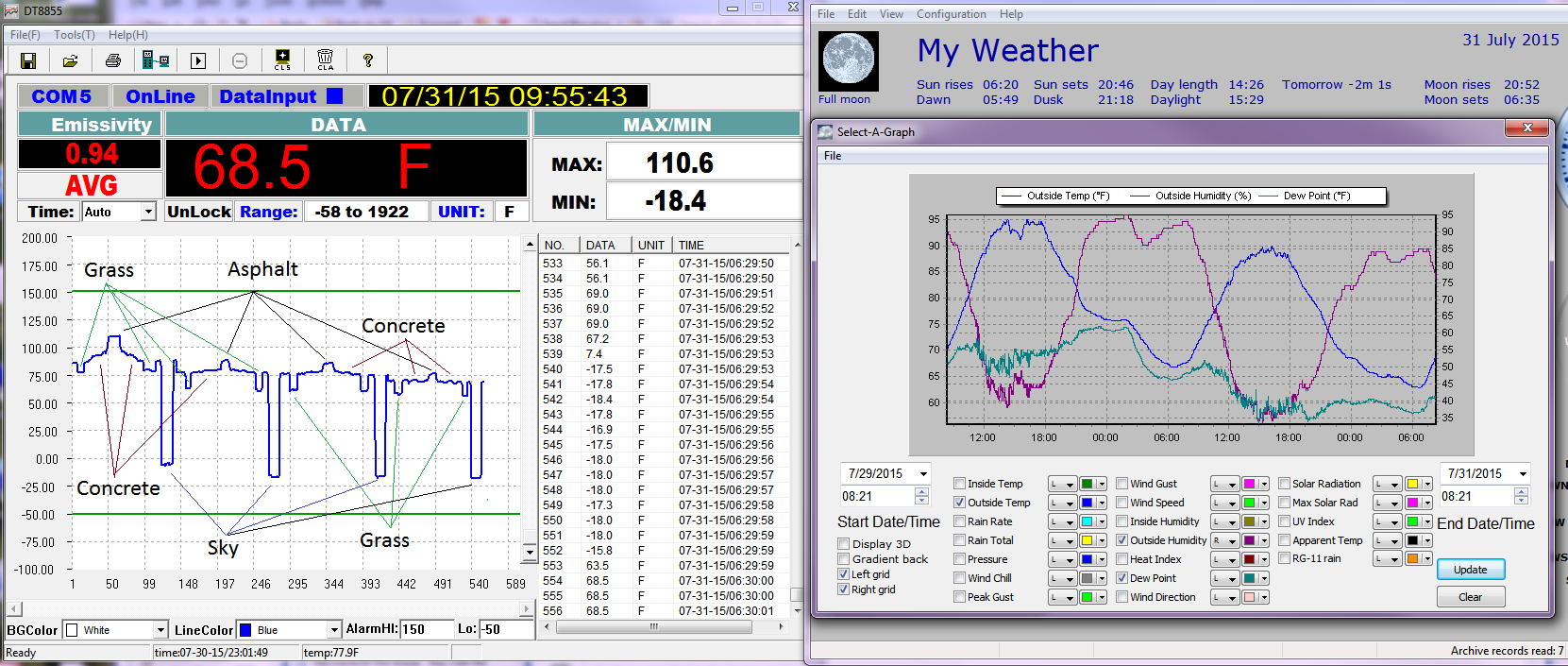
A little explanation of these would be nice. I deduce the left one is from readings of surface temperatures with an IR thermometer. Except we’re talking air temps here.
The right one is muddier than necessary. I stopped (if indeed I ever did) displaying relative humidity on my temperature graph. It’s too close to being the inverse of temperature. I suggest you display just the air temp and the dew point. Dew point shows the changes in the air mass, very useful. Here in New England, the TV Mets spend much more time talking about dewpoint than relative humidity. It’s almost like they know we know that it’s high in the morning and low in the afternoon and really doesn’t tell us ground dwellers anything that isn’t available from air temp and dew point.
I thought we were talking about UHI and thought IR surface temps were applicable.
I do need to include time lines on the IR though, but approximately max daily air temp (so 5 or 6 pm), through the evening until Sunrise the next morning. The slope of the concrete was from the shadow of the house moving from the front of the house (starting point) to the asphalt driveway from about 2:00pm to 5:00pm.
Except, you can see how rel humidity increasing impacts the cooling rate of the air temp (or more accurately ground temp), dry air cools off very quickly, humid air not as fast, the earth much much slower, unless it’s covered with grass (and I would presume trees).
This is why grass, trees, cars, all get frost, and sidewalks not as often.
Air is just the medium between the earths surface and space that the earth cools through.
90 F plus temps have wind barbs and below 90F don’t. How come? Hot air rising along the up slopes?
” 90 F plus temps have wind barbs and below 90F don’t. How come? Hot air rising along the up slopes?”
That, or rushing in to back fill convection.
I get a lot of wind during the day that drops to nothing at night, day after day at times.
Now I do live 3/4 the way up a valley, but it’s actually flat here.
So I don’t know, just I’ve been surprised by a lot of what I see my surface station recording.
It should be pretty easy to separate the UHI effects from the noise effects with a little statistical analysis on the time series. If the hot spot jumps around, it’s noise. If the same station is always the high one, it’s UHI of one form or another.
The variation in temperature readings is due to the hills of the city. Note the extended line of 90+ F temps along Market St from east to west. That line of high temps sits in a valley which is surrounded by hills on 3 sides, only the east end is open to the SF Bay. All of the other hot spots are also sheltered bowls within the hills. I grew up in the Marina District with all of the Italians back in the 1950s.
Or a defective sensor.
The hot spot near me on WxUnderground is a bad thermometer.
From experience with my own weather station I suspect sun/shade may be a large part of the explanation.
Despite having a sunshade, it is still influenced by the sun and is no substitute for a proper Stevenson Screen.
If you put a proper Stevenson Screened station near a concrete sidewalk, in a grassy field, and a shaded woods all within a a few hundred yards of each other they will all read different temps, especially if there isn’t much of a breeze.
You can feel it just riding a motorcycle riding through the shade of a tree.
Micro6500. I too noticed the temperature differences when riding a motorcycle into and out of a small town of 20000 in the summer time. Also big changes were noticed when I defended into a valley of 100 feet or so.
That is essentially a personal experience of the fact that all temperatures are an intrinsic property of one object. Averages of different ones over space and time yields a statistic about the set, but not a temperature.
In SF I would regularly shift side of street to get sun or shade and a 10 F or so change of comfort. Similarly, streets aligned with wind cool, those cross wind not so much.
The whole farce of global warming rests on the fraud of averaging temperatures and calling it a temperature change. Intrinsic properties make that a funamental and uncorrectible error.
Yes. Makes one wonder if their is any calibration of instruments, meta-data collected, or any quality control. It is easy to put our an array of sensors, collect the data, and never look back. Apparently there are no standard citing criteria, or periodic checks on the equipment or data. Shoddy and irresponsible work.
Was there a update lag on some stations I wonder?
I have noticed on Canadian parts of the Wundermap that when you look at the station ID, it isn’t always correct for the location shown. I collected some of these incongruities and notified Weather Underground using their strange correction notification process but it seems like an ongoing problem. The map is not perfect.
I’ve been keeping my own very personal record of temp, rain, etc. here in Mechanicsville, a few miles outside of Richmond, and comparing it with the record published in the Richmond Times-Dispatch and originating at RIC, Richmond International Airport, which abuts the city of Richmond (or Henrico, for part of it) to the west and north, and fairly open country, albeit crossed by large highways, south and east. Obviously, my own record is subject to many flaws and vicissitudes, though I do my best to observe the actual high and low right here at my house, which sits at a border of town and country. There are no street lights here, but I can–if I listen closely–hear the I-295 traffic on winter nights, a few miles to the west (in summer, the insects are too noisy). So my location, while close to developments and at the edge of a quiet neighborhood with acre-plus lots, is still much more rural than the airport.
I started my record in summer of 2013, so it’s been going on for just over two years. In that time, the high temp here has rarely matched or exceeded that at RIC, and the low has sometimes been quite a bit lower. On average, I’d say the difference is fairly consistent at two or three degrees F. I also compare that average with the long-term average (which the paper calls “normal” and I do not, for reasons given elsewhere on this site), and it is rather consistently below average out here in the sticks. What I lack, and wish I had, is any sort of long-term average or even a long-term record, for here in Mechanicsville. Are this year’s figures at, above, or below the long-term Mechanicsville records? I have no way to know; there seems to be no weather station here.
Much as I enjoy keeping these records, I have not offered them to the Weather Service or anyone else, since I can’t vouch for their accuracy. My instruments are simple and rough, and my times of checking are irregular. I like what I have, but can’t imagine it would be of scientific use. I shall continue to have my fun.
While probably not as granular as you’d like, I’ve built 1×1 degree averages for the land based stations in the NCDC’s Global Summary of Days stations, both daily and annual averages.
https://sourceforge.net/projects/gsod-rpts/files/Reports/LatLon%201×1%20Box/ .001-4 zip format files have both daily and annual data.
Living in the city, I too compare my back porch thermometer (which I have calibrated vs. a lab quality thermometer) reading to the RIC readings and find that mine are usually warmer, sometimes as much a 5 degrees F. There’s your UHI for ya.
What I lack, and wish I had, is any sort of long-term average or even a long-term record, for here in Mechanicsville.
Can’t find anything for Mechanicsville. Berkely Earth has fragmentary records for Westbrook Sanatorium (37.6N, 77.4W, 1895-1900 and 1946-1948) that was closer than Richmond. Frustrating that records for the intervening years are apparently lost.
http://berkeleyearth.lbl.gov/auto/Stations/TAVG/Text/32353-TAVG-Data.txt
I lived SW of Pocahontas State Forest for 10 years. It wasn’t unusual for me to put the top down on my car leaving work south side of Richmond, but get a chill riding through the creek bottom on Qualla Rd by the forest. I never measured the temps, but I’m sure the difference was more than 5 degrees. It could have been 10.
Not as dramatic, but this past June I had occasion to be a few miles outside of a city (official population 58,000 + or -), and noted the temperature as 82 degrees F. As I came into the outskirts, I watched to see if I could perceive an UHI, and sure enough, the closer to the city “center” (western cities are a bit more diffuse than their eastern counterparts), the temperature rose to and settled at 89 F. The local “bank” temperatures were reporting 90, give-or-take, so I have every reason to believe the unit I was using had a measure of accuracy.
UHI is alive and well!
“So what is the correct temperature for San Francisco at any given time?”
I’ll bet my Big Oil check that it’s always the highest that is “correct”. The lower values are then “corrected”.
No. The higher value is correct for this year, but some of the lower values are correct for last year, and more of the lower values for the year before that, etc.
A place I sometimes work, near the Bay, a few miles south of Downtown … orientation of glass covered buildings makes for a de facto solar reflector array, like a sliver of the ones in the Mojave. Stand at the right point in the parking lot and you might reasonably worry about ill effects to health. No birds scorched thus far, but that’s only because it’s a sliver of an array.
There is a very similar situation in London (the real one in the UK) where one particular building reflects sunlight into a spot which gets really hot:
http://news.nationalpost.com/news/london-skyscrapers-deathray-reflection-is-melting-cars-burning-businesses-but-also-cooking-eggs
Wonder where the “weather” stations are situated there?
This is definitely an analogous situation.
Cue Mosh:
Meh, there’s rarely any no-wind situation.
Or:
Meh, the cool stations are shaded.
Thanks, Anthony.
The correct temperature for San Francisco, or anywhere else, is the one measured by satellites.
Thermometers are way too much affect by the micro-climate around them, man-made and natural.
Andres,
How do you a satellite to measure the temperature in say, San Francisco?
It doesn’t, it measures starting a couple of miles up and going higher, in the troposphere.
https://www.google.com/maps/place/San+Francisco,+CA/@37.775657,-122.4194219,17z/data=!3m1!1e3!4m2!3m1!1s0x80859a6d00690021:0x4a501367f076adff
“Cue Mosher rant in 3…2…1”
[Mosher]The BEST algorithms adjust for that.[/Mosher]
/grin
Weather Underground appears to exert ZERO quality control over their stations: http://www.wunderground.com/weatherstation/installationguide.asp
Note that the instructions say nothing about the need to meet certain conditions if you want to be able to register your station.
So you can’t believe their numbers.
I don’t really disagree, but I will add that a large number official surface stations aren’t any better.
From my experience at work checking to see if I want to go outside for our post-lunch walk, there’s a lot of error in them thar Wunderground stations. There’s a lot of variation in station quality, siting, and maintenance.
I won’t take the time to learn which stations in the SF area are untrustworthy, but I’d start there.
Next I’d pay attention to all the microsite issues around SF. Between the cold Pacific and the hot Silicon Valley there’s no such thing as typical temps. (To say nothing of things like the hot AG areas sucking in cold Pacific air in the summer (cue Mark Twain)).
Don’t need Mosher to rant about SF weather – and I’ve never lived there….
“Silicon Valley”
Do you mean Santa Clara Valley?
I had a sail boat in the bay for a few years. It took me a long time to find a marina with little fog and wind. Just a half mile either direction there was lots of fog and wind.
The weather is highly variable in California. Seattle has more sunny days than Sacramento in February. At 2000 foot elevation in the Sierra foothills, it most often warm and sunny in the winter and really ugly at lower elevations.
California is beautiful place if you can tolerate a clueless government that tells you how to live.
Santa Clara Valley is the right term. I live in New Hampshire but used to attend a week-long computer networking meeting in San Jose in Feb/Mar. After my sister moved to Berkeley I found a great little book on Bay area weather through the seasons, bought it, and left it with her, hence my delusion of knowing something about your weather. My first trip to California was to start my first ever longer than one day bicycle in 1974 (from Palo Alto to Billings MT via Canada), so I learned something about coastal weather way back then!
I prefer New Hampshire. A lot of weather in a small place. We pay our 424 legislators $100/year each (they’re worth every penny), and if they get too cocky, our constitution’s Bill of Rights commands us:
I’ve seen days in Salt Lake City where the temperature at the airport and the temperature at the U of U campus were more than 20 degrees apart, really not well explained by a 700 foot difference in elevation.
Years ago, we lived in Superior, WI, right across the river from Duluth, MN. Duluth is on a hefty ridge–really a low mountain–about 900 feet above the level of Lake Superior, so that the weather on top (and past the top) of the hill can be markedly different from that on the lakeshore, especially if there is an onshore wind. The weathercasters there usually give two temperatures: at the airport (on top of the hill) and at the lakefront. I have heard them close to 50 degrees apart (“It’s a warm one over the hill, 91 degrees; but with the east wind onshore, the lakeshore temperature is a brisk 42 degrees”). It’s not commonly that drastic, of course; but the nature of the place is that a sudden wind change can drop the temperature deeply and abruptly, from (say) the 80s to the 40s in a few minutes. That can be uncomfy if you are in swim gear next to the lake. The difference can be even greater when the ice is late going out. The year we moved to Superior, there was still ice in the harbor–lots of it–until the 10th of June, so sudden breezes off the lake could actually be at freezing temperature close to shore. I still have to say that Duluth-Superior may have been our favorite of all the places my wife and I lived, much as I love Virginia now.
In my view, thermometers in city centres always give misleading results, buildings, heated in winter, air-conditioned in summer, cars with engines running humans emitting 200 watts of body heat and last but not least asphalt, stone and brick which emit heat long after the sun goes down.
The first house we bought is about 300 yards away from where we now live, our first house had a north facing back garden, our current house has a south facing back garden. The difference in temperature after the Sun had set was substantial due to the bricks of the houses and he concrete patios absorbing the heat energy from the Sun and emitting it back again at night
And in our case with all of our illustrious cloud tech places with server farms (yep, server farms in downtown high rises, we’ve got ’em), the added thermal output from all the HVAC creates micro-micro-climates.
Didn’t we read, some months ago, about a high-rise in New York that had mirrored windows, and was focusing sunlight into a small area? Any chance that this is something similar; a solar “death ray” caused by nearby mirrored windows?
In field studies, this is why we use replicated random sampling with an adequate sample size.
The fact that this has NEVER been done by any of the data employed to portray global warming, climate change, climate disruption, global cooling simply means that the data is trash. The variance of a sample size of one is infinity.
This has been the case for the last 30 years of BS and remains so today. For satellite data too or did you not consider that one sat still a sample size of one.
“For satellite data too or did you not consider that one sat still a sample size of one.”
Satellites are calibrated against weather balloons–and each other.
Uh huh, yeah /skeptical. Have you ever done the basic calculation to determine the sample size required to accurate determine the mean of any day’s temperature to the “closest subdivision” of a degree reported ? How many satellites did you say you have ?
Sadly, climate science is soft science like sociology at best or pseudo-science at worst. But since they claim global warming causes smaller brains, perhaps that is the best we can do.
Forgot to mention that lovey episode of sat data reporting something like ~ 458 C in large portions of the Lake Michigan area – all going into the permanent data set, we are told. They fly weather balloons in that one ?
I have seen the temperature change 10 degrees caused by elevation changes driving into San Francisco. Just moving a station half a mile would have a bigger effect on temperature than climate change.
looking at google maps for the higher reading one in the second screen grab, that 81degree temp
it is RIGHT next to a large apartment complex with HUNDREDS of angled solar panels. would it be possible that the sunlight reflection from-some- of the panels is influencing said station.
Temperatures in the mid 90s in some points at 8 AM? This sounds to me like some poorly sited stations being affected by sunlight. I suspect the hotter stations are getting air heated by a nearby sunlit surface. Another thought I have is air heated by air conditioning condensers, although I wonder how much there is of that at 8 AM in San Francisco.
Oops, now I see the time was 2:15 PM. Meanwhile, I still think that the various stations are having very different effects from poor siting, and the hotter ones are being affected by nearby sunlit surfaces and/or air conditioning condensers. I think the inland air temperature in San Francisco at that time was in the low 80s.
Yes, there was a minor sea breeze yesterday and it had in fact kicked in by 2:15 PM, at least it had in the northern part of the peninsula. Even prior to the sea breeze the offshore winds driven by the double barrel high would have exerted cooling in the concrete canyons via their sheer amount of mass flow.
Another thought for variation in San Francisco: Temperature inversions are common there because lower altitudes of the air there are often cooled by the ocean and the bay, while higher altitudes even as low as some hilltops and tops of tall buildings do not get such cooling. I noticed this while riding my bike up and down two hills between the Golden Gate Bridge and Muir Woods on a day when the non-water-cooled layer of air was very warm.
I just checked the 3-day weather history for San Francisco downtown and San Francisco International Airport, for times around 2 PM on 9/8. There was indeed a large variation of air temperature. Temperatures closer to 80 look like that occurred in air that was cooled by nearby waters, and temperatures around 91-94 were in air that had less or no cooling by nearby waters. It looks like wind overall was very light, and sea breezes had effect varying widely with location and elevation.
It must be global warming at the block level. Send in the Census Bureau to investigate and track over time.
This is why climatology is little more than phrenology. SAT is determined by convention and convention alone.
http://data.giss.nasa.gov/gistemp/abs_temp.html
IPCC AR5 didn’t deliver a solid number for mankind’s CO2 contribution between 1750 & 2011 (+/- 76% sq rt sum of squares), the added 2 W/m^2 of RF due to that increased CO2 is lost in the magnitude and uncertainties of the global heat balance esp. the water cycle (clouds -20 W/m^2 +/-?), IPCC AR5 admits their GCMs didn’t model the hiatus/pause/stasis/lull (because their CO2/climate sensitivity is way too big).
IPCC hasn’t a climatological clue. Nuff said.
All the other discussions are academic white noise, moot, sound and fury signifying nothing.