Bárðarbunga volcano getting ready to blow? 1000 Earthquakes felt as magma moves into ice covered caldera

yearly_activity[1]From the Icelandic Meteorological Office:

A summary of seismic activity, written Tuesday evening 19th August 2014 at 20:00

Around 1.000 small earthquakes were detected in the Bárðarbunga region from midnight (18/19) until Tuesday evening 19th August at 20:00. All of them were smaller than magnitude 3 and most were located in the cluster east of Bárðarbunga.

While the northern cluster close to Kistufell has calmed down significantly following the M4.5 earthquake on early Monday morning, event rates in the eastern cluster are still high. Similar to recent days, two pulses of comparably strong seismic activity have been measured between 04:00 and 08:00 this morning, as well as 16:00 and 18:30 in the afternoon. The cluster east of Bárðarbunga continued to slowly migrate northeastwards today. Events are still located at around 5-12 km depths, no signs of upwards migration has been seen so far.

Below is a summary map of all manually revised earthquakes since the onset of the swarm, which illustrates the migration of earthquake activity during the last days. Earthquakes in the map are colour coded by time, dark blue dots show the onset of the swarm on Saturday, orange dots Tuesday’s events until 19:00, light blue and yellow are the days in between. The time scale is days since the onset of the swarm.

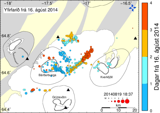
Map by Gunnar B. Guðmundsson, Icelandic Meteorological Office.


via WUWT commenter “unmentionable”:

From the quotes below it sound like they’re crossing their fingers and toes that this thing stays underground and does not get any bigger. the longer the tremor goes on like this the worse its going to be if it pops under 2,000 ft of water ice.

___

Magma flowing into Bárðarbunga caldera with great force – 20th August 2014

http://www.visir.is/magma-flowing-into-bardarbunga-caldera-with-great-force/article/2014140829931

Kristín Vogfjörð, seismologist and research director at the Icelandic Meteorological Office, says that the activity is very powerful. “This just keeps going on. This is many times more powerful than what’s been going on in recent years.” Kristín says that a large volume of magma is flowing under the caldera, heading northeast towards the Kverkfjöll mountain range. The magma is staying at a depth of 5-10 kilometers – there are no signs of it moving any closer to the surface. If asked if an eruption is due to happen in the next few days, Kristín responds: “Not necessarily. There’s nothing suggesting that it’s about to. But due to the size and scale of the activity there’s full reason to be vigilant and prepare for an eruption.”

Magma surge towards the surface would be very powerful – 20th August 2014

http://www.visir.is/magma-surge-towards-the-surface-would-be-very-powerful/article/2014140829927

Kristín Vogfjörð, research director at the Icelandic Meteorological Office, says that the current seismic activity at Bárðarbunga is many times more powerful than any on record for the site. “It’s very powerful,” she says. For comparison she notes that thousands of quakes have been measured at Bárðarbunga in the past week, but in the Gjálpar eruption in 1996 they were only a few hundred. … “While this is going on, it may never reach the surface. But we still need to keep an eye on it because the volume of magma is incredible,” she adds. …”There is no indication that it’s moving further up than that. But if it were to happen, it would happen very quickly,” Kristín states.

0 0 votes
Article Rating
158 Comments
Oldest
Newest Most Voted
Inline Feedbacks
View all comments
August 20, 2014 3:47 pm

Reblogged this on gottadobetterthanthis and commented:
Oklahoma has nothing on Iceland! That one little island is having 50 an hour.

August 20, 2014 3:52 pm

North Atlantic tectonics about to strike?
See Vuk’s graphs

SasjaL
August 20, 2014 3:55 pm

… and the emitted carbon dioxide … ?

E.M.Smith
Editor
August 20, 2014 3:58 pm

Large volume means cools slowly. There’s a lot of molten rock down there that is not going to be solid any time soon… unless it’s not down there anymore…
Hope this doesn’t happen.

RACookPE1978
Editor
August 20, 2014 4:12 pm

Hockey stick alert!
(Oh wait. This is based on real measurements …)

Worried Lank
August 20, 2014 4:16 pm

What happens now? Iceland has a population of about 330,000 people – when does the evacuation of these folk start? Do we wait for this to blow and take the risk it will wipe out most of the island?

August 20, 2014 4:16 pm

When the volcano blows it will perhaps create another Island like Surtsey. Surtsey was created in 1963 by an eruption in Iceland. Iceland is on the Mid Atlantic Ridge and as such is separating. Half of the Island is moving towards Europe and half to North America. The separation is about 6 feet in 60 years.. In parts of Iceland you can walk through the separation gap in the expansion joint. So Iceland will always have Volcanic and Earthquake activity as our Planet Expands. What we have to do as ,supposedly intellegent people, is to accept the earth expansion reality and debunk “Isostatic Rebound” Isostatic Rebound has been mistaken for Earth Expansion all along. The Ice age therefore is a Myth and I can prove both hypotheses. Earth Expansion has been ongoing for millions of years while Isostatic Rebound is the figment of Darwin’s imagination which gained a following and resulted in the Rebound Theory. Nothing like that is reality it all a myth. Earth Expansion has been miatakenly termed Isostatic Rebound because as the Earth Expands Se alevels fall. and that is where Darwin went wrong.
Richard Guy ” THe Mysteriouos Receding Seas” on You Tube and Google and WEb Page : https://xbraille.wix.com/receding-seas Tel; 914-563-8529

AJB
August 20, 2014 4:18 pm
george e. smith
August 20, 2014 4:30 pm

Kawabunga ! , that will be something to see, and write a new chapter in the “here’s why the models don’t work” soap opera.

Russ in TX
August 20, 2014 4:35 pm

What does it mean when somebody describes a volume of magma as “incredible?” I’m not a vulcanologist — is this typical media hype-talk, or does “incredible” actually mean just that?

Worried Lank
August 20, 2014 4:44 pm

From Paul’s link ….”Barðárbunga stretches out over 200 kilometers long. It has a large eruption every 250-600 years. One of its eruptions before settlers arrived was 21-30 cubic kilometers of lava. Like her little brother Laki, she’s associated with massive amounts of toxic gas release.”
Mt Pinotoba produced about half the lava of this and without anywhere near the volume of gas. And of course it was not under ice cover so the lahars from Pinotoba will be nothing compared with what could happen here!

Anything is possible
August 20, 2014 4:58 pm

If it blows, we will have excuse #32 for the pause……

CC Squid
August 20, 2014 5:01 pm

http://volcanoes.usgs.gov/hazards/lahar/
“Lahar is an Indonesian term that describes a hot or cold mixture of water and rock fragments flowing down the slopes of a volcano and (or) river valleys. When moving, a lahar looks like a mass of wet concrete that carries rock debris ranging in size from clay to boulders more than 10 m in diameter. Lahars vary in size and speed. Small lahars less than a few meters wide and several centimeters deep may flow a few meters per second. Large lahars hundreds of meters wide and tens of meters deep can flow several tens of meters per second–much too fast for people to outrun.”

August 20, 2014 5:12 pm

Reblogged this on The Next Grand Minimum and commented:
Volcanic activity has played a role in grand minimum cooling. We could see some Norther Hemisphere cooling with the eruption of this volcano.

tgmccoy
August 20, 2014 5:15 pm

Two good sources for info:
http://volcanocafe.wordpress.com/
http://www.wired.com/category/eruptions/
I have a bad feeling about this..

August 20, 2014 5:21 pm

The prevailing winds in Iceland are toward the east and the most heavily populated area of Iceland is to the west and southwest of Bárðarbunga. That may mitigate the effects somewhat on the population if a major eruption occurs.
John

Michael 2
August 20, 2014 5:28 pm

My Icelandic was never very good but the right hand legend is “Days From” and the color codes are how many days after 16 August 2014 so you can see the tracks.
Yfirfarith (the crossed “d” is a soft “eth” like the th in “mother”) means Yfir (over) farith (the fare, traveling, go, as in English “fare” like fare well).
Or in other words, traveled over (land) starting from 16 August for 4 days.
This is almost on the centerline of the watershed flowing northeast and southwest under the largest glacier on east central Iceland. It would produce an enormous amount of water that would break loose in a flood going both directions cutting off the ring road. It’s far enough from Reyjkavik to not perhaps be a serious problem to the city.
It might pose a risk to Kharanjukar dam.

Leon Brozyna
August 20, 2014 5:39 pm

Hope this thing fizzles out … if it blows, it’ll ruin the day for a lot of people … and give us another bitterly cold winter.

tz
August 20, 2014 5:39 pm

If it erupts it might send a billion pounds of chlorine directly into the stratosphere. Of course those are good little chlorine atoms, not like those horrid man-made chlorine compounds that stay near the ground and when the ozone molecules see them from 50 miles up they decompose. Nor all the other hydro-X gasses that when in water form sulfuric, nitric, or hydrochloric acid. Don’t be silly, acid rain comes from coal fired plants – including when Portland OR had clothing dissolving a century ago, it couldn’t possibly be from the erupting Alaskan volcano.
Now if only Mt Ranier erupts totally destroying the Puget Sound area and disrupting those awful coal trains…

Bob Diaz
August 20, 2014 5:47 pm

If it blows, I’m sure that someone will blame it on increased CO2.

Barbara Skolaut
August 20, 2014 6:15 pm

“If it blows, I’m sure that someone will blame it on increased CO2.”
And the usual suspects will blame it on Booooooosh, Bob. (Or the Jooooooos. Or both.) >:-(

u.k.(us)
August 20, 2014 6:17 pm

Time to listen.

SAMURAI
August 20, 2014 6:20 pm

You can bet the CAGW grant hounds are desperately praying to the volcano god Pele that this gigantic volcano blows it’s top, because if it does, it’ll be the ultimate excuse to explain away the 18 years of flat/falling global temperature trends and future anemic trends for decades.
Volcanism is already a common excuse used by CAGW grant hounds to explain away the entire Little Ice Age (1280~1850) that lasted for about six centuries..
If she blows, and it’s as big as previous Baroarbunga eruptions, it could well be a career saving phenomenon for many of these feckless hacks.

August 20, 2014 6:24 pm

Interestingly enough, there appears to be a link between volcanic activity and solar activity at maxima and minima during 11 year cycles.
http://pubs.giss.nasa.gov/abs/st07500u.html

August 20, 2014 6:33 pm
ossqss
August 20, 2014 6:34 pm

I don’t like it. Keeping an eye on Katla was onerous too.
So much to learn in this field yet.

Jeff
August 20, 2014 6:54 pm

Mr Mann and The Team will have had jizzed themselves after seeing the ‘Seismicity at Bárðarbunga’ graph. Hockey sticks hockey sticks everywhere

RACookPE1978
Editor
August 20, 2014 7:10 pm

Trends.
The Good News is … The plotted earthquakes are not getting closer to the surface, nor are they significantly larger over these four days.
The Bad News is … The are getting slightly larger as they trend to the northeast; the newer earthquakes are slightly larger over time than the earlier earthquakes.
The Good News is .. They are getting further from the (previous) volcanic peak, and so may not erupt like it did previously.
The Bad News is … They are trending to the northeast, which IS the dominant direction of the surface features (the fault lines) and IS parallel to the Great Rift; thus, the earthquake centers are closer to the surface and to flaws in the surface that can vent lava, gas, and ash more easily.
The Good News is … They are trending further from the volcanoes peak .
The Bad News is … They are trending in a direction where the mountain is lower, thus the earthquakes (magma pockets) are closer to the surface.
The Good News is … The earthquakes are trending to the northeast, which means they are closer to the edge of the glaciers on the mountain peak.
The Bad News is … They are trending to the northeast, which is the line directly under the longest length of the glacier ice. Also, if the magma breaks through, ice upstream (uphill) of the lava is likely to melt anyway, slice downhill towards the venting gas and magma, and melt anyway right in the lave, thus spewing steam and gas even further into the atmosphere. If the lava heated rocks which melted all of the glacier ice before the lava breaks out, then the water can flow off downstream “a little less” catastrophically. May still flood, but more slowly.
The Bad News is … Many glaciers are thinnest at the very top(where little ice has been deposited yet) and at the very bottom (where melting is highest and temperatures warmest). If the lava breaks through in the middle of the glacier, more glacier ice is directly above the new volcanic vent since the glacier is likely thickest in the middle of the run.

bushbunny
August 20, 2014 7:11 pm

I don’t want to sound alarmist, but back in 1200 BC, there was a swarm of earthquakes happening around the middle east and volcanic eruptions.

njsnowfan
August 20, 2014 7:13 pm

Solar Notch model may be right after all with it’s free fall in global if it blows high into the stratosphere.
“Ice Age”

njsnowfan
August 20, 2014 7:13 pm

Temps

ossqss
August 20, 2014 7:30 pm

RACookPE1978 says:
August 20, 2014 at 7:10 pm
———————————————–
I would certainly like to see any sat based elevatiion change as such a pyroclastic flow continues ,underground, to move. Force vs pipe if you will. I would hope we have some GPS devices located in the area too boot!
Is it an earthworm making progress of a mole following a hole?
Somebody has to have some linkage to such…….

bushbunny
August 20, 2014 7:34 pm

Ice Age, actually during the last ice age, there were more seismic and volcanic eruptions than now.
But usually any dust depending in which direction it moves, doesn’t stay around forever. Well I hope so anyway.

ossqss
August 20, 2014 7:35 pm

Mods, or a mole, not of. Help please……
Sorry, testing a BT keyboard and mouse on a TV tonight.

Michael D
August 20, 2014 8:17 pm

Jocularity aside, we certainly don’t want another Krakatoa. Good wishes to Iceland !

crabalocker
August 20, 2014 8:21 pm

Not sure if this is accurate info or not but something I came across….worth the quick read though:
“The winter of 1783-1784. The Revolutionary War had just ended, and Benjamin Franklin was puzzling over the nation’s bizarre weather. Congress had been delayed getting to Annapolis to vote for the Treaty of Paris because the Chesapeake Bay just wouldn’t melt. The Mississippi River froze down to New Orleans, and ice was reported floating in the Gulf of Mexico. Reports from Europe were of a bizarrely hot summer with thick fog that was choking people to death in Scotland, massive hailstones, lightning, and crop failures. The sun was blood-red at noon. Mass starvation that would ultimately kill 1/6ths of Egypt’s population took hold due to a historic drought of the Nile. As many as six million people would die from the bizarre weather.
Franklin was one of the few scientists of the era to (almost) correctly speculate as to its cause:
“The cause of this universal fog is not yet ascertained […] or whether it was the vast quantity of smoke, long continuing, to issue during the summer from Hekla in Iceland, and that other volcano which arose out of the sea near that island, which smoke might be spread by various winds, over the northern part of the world, is yet uncertain.”
He, however, had mixed up his Icelandic volcanoes, for it was not Hekla that erupted that year, causing the planet-altering weather, but Laki (Eldgjá). A rift 23 kilometers long opened up in places up to 100 meters wide with lava fountains at times reaching over a kilometers into the air – and it continued erupting for 8 months.
The total quantity of lava erupted – 14 cubic kilometers – was not that much more than Mount Pinatubo (largest eruption of the 20th century)’s 10 cubic kilometers. But the eruption kicked out a staggering 120 million tons of sulfur dioxide, compared to Pinatubo’s 17 million – nearly supervolcano levels. Also unusually, Laki emitted 8 million tons of hydrogen fluoride – normally a trace volcanic gas. These gasses created the “Laki Haze” across Europe. In Iceland, the consequences were most severe – a quarter of the population starved or died of fluoride poisoning, and most of the livestock died. Denmark considered evacuating the entire island.
Is Laki threatening to go off? No. Then why do I mention him?
Because his big sister IS threatening to go off.” ……Bardarbunga

bushbunny
August 20, 2014 8:23 pm

Back in the forties, my mother blamed the bad weather and cold winters on atmospheric atom bomb explosions. Might be too.

crabalocker
August 20, 2014 8:48 pm

oops, disregard my previous post….I see there’s a link above to it. Sorry Paul.
But here’s a web cam ….hope it’s not posted above http://www.livefromiceland.is/webcams/bardarbunga/

Bill Illis
August 20, 2014 8:51 pm

Webcam from the Grimsfjall nearby volcano shows the eruption has started.
http://vedur2.mogt.is/grimsfjall/webcam/
Others not showing it.
http://www.livefromiceland.is/webcams/bardarbunga
http://vedur2.mogt.is/kverkfjoll/webcam/index.php

TomR,Worc,MA,USA
August 20, 2014 9:02 pm

Michael D says:
August 20, 2014 at 8:17 pm
Jocularity aside, we certainly don’t want another Krakatoa. Good wishes to Iceland !
=========================
..or Tambora . Yikes. All the best to Iceland.

Bill Illis
August 20, 2014 9:16 pm

Sorry, didn’t realize this links would show up. Website has changed I guess.

bushbunny
August 20, 2014 9:31 pm

Is that dust Bill? Or Ash?

August 20, 2014 9:32 pm

Not sure if that is new? There was a glowing area in those shots several hours ago.

crabalocker
August 20, 2014 9:33 pm

could that just be the sun starting to rise through a light sensitive camera and fog?

August 20, 2014 9:36 pm

That mogt.is site is running epically slow… must be getting a ton of hits.

August 20, 2014 9:52 pm

I guess it is just sunrise.
Sun comes up pretty early in Iceland at this time of year.

goldminor
August 20, 2014 9:57 pm

Here is another web site that does quakes and volcanoes. Armand Vervaeck does a great job with the information he shows….http://earthquake-report.com/2013/05/27/wordwide-volcano-activity-copahue-volcano-chile-alert-raised-to-red/

Peter
August 20, 2014 10:10 pm

With what is going on in Iceland, is this information fed to the airlines that fly over this island? Would the airlines avoid flying over Iceland if the information being gathered appears to be pointing to a possible eruption?

August 20, 2014 10:27 pm

That ain’t a hockey stick, it’s a putter. But the time series does not tell the real story, the geographic distribution does. It is a soliton wave progressing northeastward on a path if the grey color is any indication has been followed many times before.

crabalocker
August 20, 2014 10:51 pm

@ Peter,
They’d know but not sure what Icelandic air traffic control protocol is. Do they restrict the airspace? I’m pretty sure there would be a NOTAM and airline companies can choose to file around the area but I’m not overly familiar with oceanic control.

Patrick
August 20, 2014 10:54 pm

Authorities have evacuated residents in the area. This sounds quite serious.

MAK
August 20, 2014 11:03 pm

Most of the events are now in the depth of 1 to 5 km. This link shows this in realtime:
http://baering.github.io/

August 20, 2014 11:38 pm

Everything is still OK here in Iceland. But while we are waiting… What Does an Earthquake Sound Like?…
What do earthquakes and music have in common? A lot, says musician Halldór Eldjárn. He has set up a webpage where he has converted the earthquakes from Bárðarbunga volcano to music. The Reykjavík Jazz Festival ends today and thus the experiment is very timely.
“I just had to do this,” Halldór told mbl.is. He started working on the project last night and published it early this morning. “Some guys had made a 3D graph but since music is my scene, creating music on the computer in one way or the other, I thought it would be just the thing to use the data for this purpose. I use the depth and size of each quake to make the tones. I use a certain scale to make sure it does not sound like complete nonsense. A low tone means the quake occurs way below the surface. The more frequent the quakes become the more notes there will be. In case there is an eruption this will sound like heavy metal rock!” Halldór continued.
Listen to the results of his project at his webpage, The Sounds of the Earthquakes in Bárðarbunga:
http://halldorel.github.io/

August 20, 2014 11:40 pm

A young programmer mapped the Bárðarbunga quakes in a 3D model:
http://www.visir.is/mapped-the-bardarbunga-quakes-in-a-3d-model/article/2014140818807

James Bull
August 20, 2014 11:44 pm

What always boggles my mind with volcanoes is the volume of ejected material, from cubic miles/km of ash and rock to the amount of gas of all sorts. Having worked with CL2/SO2 liquid in 800kg drums it is hard to imagine many many times those volumes pouring out of a volcanic vent.
Lots of volcanoes gently vent these gases all day every day but when on blows wow.
James Bull

August 21, 2014 12:08 am

Fresh news in English can sometimes found here. Look for “Bárðarbunga Volcano Watch”:
http://grapevine.is/

Patrick
August 21, 2014 12:20 am

“MAK says:
August 20, 2014 at 11:03 pm”
Activity at that focal depth would be tectonic rather than volcanic?

AleaJactaEst
August 21, 2014 12:31 am


That has to be one of the coolest things I’ve seen. I work in real time oil and gas exploration drilling visualisation and we update wellbore trajectories and petrophyscial logs in apps like this.
Awesome.

August 21, 2014 12:34 am

Video from the 1995 Gjálp in Vatnajökull eruption and glacier surge (jökulhlaup). German language:

Long (50 min) Video about Vatnajökull. English language:

August 21, 2014 12:53 am

Directely to the 3D model video:

Unmentionable
August 21, 2014 1:07 am

Lots of very recent consistent small shallow ‘quakes’ over a large area, some high quality:
14.5 km SE of Kistufelli Mag=1.3 5 minutes ago depth 2km Quality 90.01%
15.4 km ESE of Kistufelli Mag=1.5 6 minutes ago depth 1.4km Quality 90.03%
13.7 km NW of Kverkfjöllum mag=1.4 18 minutes ago depth 1.1km Quality 60.82%
5.5 km NE of Bárðarbungu Mag=1 15 minutes ago depth 1.1km Quality 90.06%
13,7 km NW of Kverkfjöllum Mag=1.4 20 minutes ago depth 1.1km Quality 60.82%
5.5 km NE of Bárðarbungu Mag=1 21 minutes ago depth 1.1km Quality 90.06%
2.8 km E of Bárðarbungu Mag=0.7 21 minutes ago depth 1.3km Quality 44%
18.9 km NNW of Kverkfjöllum Mag=0.4 25 minutes ago depth 1.1km Quality 36.79%

Unmentionable
August 21, 2014 1:10 am

Mod please see awaiting mod comment(s) in the old thread – thankyou

Editor
August 21, 2014 1:31 am

Last time this happened we had taken a night flight from Miami to Paris, we landed at 08:00 very jet lagged. My son said that all flights back to UK were cancelled, I told him I was in no mood to be wound up, but I looked at departure boards and sure enough they were all cancelled. When I asked an Air France rep what was happening she said “Icelandic Volcano” in broken English. I thought she was drunk or demented. To cut a long story short as the airport kept gettting busier and busier I realised we had to do something quickly or be stranded. Air France said they would put us in a hotel overnight and fly us back to Newcastle the next day. I knew this was not going to happen, because the dust would be in the atmosphere for days. We got home early evening the following day after I booked all five of us in a taxi, two trains, a ferry another train and another taxi at a cost of £750 using a laptop in Charles de Gaulle airport. The next day I found out that 1000’s of people were stranded. A word of advice if this happens again ACT QUICKLY

Unmentionable
August 21, 2014 1:32 am

SasjaL says:
August 20, 2014 at 3:55 pm
… and the emitted carbon dioxide … ?
__
Not just that, Laki eruption, a similar duel parallel fissure-swarm, 50 km south, in 1783 released ~120 million tonnes of sulfur dioxide. There’s your less alkaline ocean mechanism right there. That’s going on under the waves as well. Iceland is just a beached version of a mid-ocean ridge rift, when all is said and done.
Volcanic cause mechanism, not silly misanthropic blame-games.

August 21, 2014 1:48 am

Michael 2 says:
August 20, 2014 at 5:28 pm
“My Icelandic was never very good but the right hand legend …”
The word “yfirfarið” on the map means reviewed or confirmed data, not raw data.
“Yfirfarið from 16 ágúst 2014” = “Reviewed from 16 Agust 2014”
“Dagar frá 16. ágúst 2014” = “Days from 16 Agust 2014”

Unmentionable
August 21, 2014 2:00 am

RACookPE1978 says:
August 20, 2014 at 7:10 pm
Trends.
The Good News is … The plotted earthquakes are not getting closer to the surface, nor are they significantly larger over these four days.
___
More trends for you, see comment just out of moderation land within the old thread
http://wattsupwiththat.com/2014/08/16/earthquake-swarm-in-iceland-raises-threat-level-on-bardarbunga-volcano/#comment-1713831
The core focus of the Bardarbunga complex is uniquely perverse in its dynamic responses to harmonic tremor and significant quakes.

Unmentionable
August 21, 2014 2:24 am

I suspect the shallow quakes that I’ve listed above are icesheet adjustments to the horizontal dilation across the fissure complex. The Dyngjuháls CGPS site continues to steadily displace (quickly) as magma fills and opens wider the fissure-swarm conduit.
http://strokkur.raunvis.hi.is/gps/DYNC_3mrap.png

Unmentionable
August 21, 2014 2:35 am

Oh, one thing more in that, when Grimsvötn blew in 2011, roughly 1 hour before it blew the ground subsided measurably, presumably due to horizontal crustal extension from magma decompression gas increase, which pushed the walls apart and undermined its cap rock.
The researchers said after that event that they wanted another eruption to test this theory on, namely that the GPS ground drop is directly proportional to the eruption cloud formed after the drop.
They may be about to get that test, note the ‘Up’ axis value just went negative. The ground near that GPS station is suddenly subsiding, even as seismic activity has intensified.

August 21, 2014 3:35 am

Most recent earthquake maps at Iceland Met Office:
http://www.vedur.is/skjalftar-og-eldgos/yfirlit/bardarbunga-2014/
Top map: Yfirfarnir skjálftar frá miðnætti = Reviewed/confirmed earthquakes since midnight.
Yfirfarið í dag = Reviewed to-day.
Klst frá miðnætti = Hours from midnight
Middle map: Óyfirfarnir skjálftar frá miðnætti = Not reviwed earthquakes since midnight.
Óyfirfarið í dag, Gæði>50 = Not reviewed to-day, Quality>50
Klst frá miðnætti = Hours from midnight
Bottom map: Yfirfarnir skjálftar frá 16. ágúst 2014 = Reviewed quakes since 16 August 2014
Dagar frá 16. ágúst 2014 = Days since 16 August 2014
“Skjálftarnir hafa mismunandi liti eftir því hve langt er liðið en skýringarnar og dagsetningu má sjá á myndunum. Dagsetningu og tímasetningu hvers korts má sjá í hægra horni (áááámmdd 00:00)”.
Translated:
“The quakes have different colors depending on the time passed, but description and dates can be seen on the pictures. Date and time for each map can be seen in the right bottom corner. (yyyymmdd 00:00”.

johnmarshall
August 21, 2014 3:36 am

Eruption possibility increases. Iceland is on the Mid Atlantic ridge/tectonic divergent zone, and it has its own mantle hotspot. Kind of double whammy.

Unmentionable
August 21, 2014 3:39 am

I see this going one of 4 ways:
(1) It stops, the system settles down and you get 50 to 100 years of smaller significant eruptions, 5 to 10 years apart.
(2) The system continues the rapid progressive horizontal WNW and ESE dilation until a cap rock gives out and an eruption breaks out as Iceland Met said, “with great force”, i.e. several kilometers of 4,000 to 5,000 ft high lava fountains slam on to giant ice sheet, periodically for several months.
(3) The rapidly increasing crustal pull-apart tension triggers a series sudden tectonic quakes that pull the multiple magma flooded rift fissures open, along an extended length. Decompression degassing pulverizes the magma to fine incandescent globules and they launch for where the shy is -55 degrees C where they shock-cool as tiny fine shards of glass that land on Brussels, Moscow and northern Japan.
(4) A strong magmatic quake opens Bardarbunga caldera and relieves the pressure explosively, from a single-point, before a tectonic quake sequence does. Given its 700 meters deep and will flood, and it’s a caldera, Krakatoa comes to mind.

1 human friendly option out of four.

August 21, 2014 3:46 am

The english volcano news web at the The Icelandic National Broadcasting Service RUV:
http://ruv.is/volcano
About RUV: http://en.wikipedia.org/wiki/R%C3%9AV

August 21, 2014 4:54 am

What was the time between the ground subsidence and the eruption observed previously?

August 21, 2014 4:55 am

Sorry, didn’t see your second post.

Unmentionable
August 21, 2014 5:03 am

Jean Parisot says:
August 21, 2014 at 4:54 am
What was the time between the ground subsidence and the eruption observed previously?

Volcanoes shift before they spew – 12 January 2014
GPS data from 2011 Icelandic eruption hint at new ways to forecast hazards.
” … “A GPS site can tell you not only that there’s unrest at a volcano, but that it’s about to erupt and then how high its plume will be,” says Sigrún Hreinsdóttir, a geophysicist at the University of Iceland in Reykjavik. … Seismic instruments can detect an impending eruption, because earthquakes usually come fast and furious right before such an event. But only the GPS data hint at the actual size of the eruption to come, Hreinsdóttir says. …”
http://www.nature.com/news/volcanoes-shift-before-they-spew-1.14498

Unmentionable
August 21, 2014 5:47 am

1 hour 20 mins ago
21st Aug 2014 10:58:09
Depth 3.1 km
Mag 3.8
Quality 99.0
4.8 km NE of Bárðarbunga

August 21, 2014 7:43 am

mag 4 earthquakes now occurring Thusday morning. I’m no seismologist but to my knowledge, that suggests strengthening and magma moving upwarward in the caldera.
Very bad jujuj. Ireland and Scotland and Northern UK look out.
http://en.vedur.is/photos/jarisls_rit/140821_1425.png

August 21, 2014 7:46 am

mods- why is WordPress sending posts to the bit bucket?
[The cause (for the greatly increased number of “wait for moderator” delays) is uncertain. The “clause list” (phrases that trip the programmed logic) has not changed recently, but the search engine (Akimsmet) may have been modified back at the source. Be patient, we’ll get through it. .mod]

Unmentionable
August 21, 2014 8:41 am

Joel O’Bryan says:
August 21, 2014 at 7:43 am
mag 4 earthquakes now occurring Thursday morning.

This can happen if the magma is running out of room, and/or the ground can’t displace and extend fast enough to accommodate the rest of the magma which is trying still trying to rise.
There’s a deep column of relatively less dense buoyant material that has been moving upward in bulk for over 130 hours. It has inertia so it doesn’t want to stop just because there’s some trouble with the plumbing above. This will be sorted out, one way or another, by earthquakes and fractures, if secular molecular creep displacement can’t do it fast enough.
Complication: New hot magma is gassy and reactive and new magma often does not mix well with old magma, and there’s always old magma.
So the new stuff either gets blocked under the old stuff, or it intrudes through it, and mostly lays above it. What strong magmatic quakes do is shake them together and increase mixing and reaction. As they mix they react more and exsolve more gas which increases the pressure further, which makes for more quakes. Even as more material below does not want to stop from rising at the same speed as prior. Billions of tonnes of stuff moving up will take a lot of stopping.

August 21, 2014 9:03 am

eventually a mag 4+ jolt is bound to open cracks to the underside of the ice sheet. Steam makes Millions of liters of water rushing into a magma chamber????
Worst case:
blows the several cubic km off the top of that ice pack. A long 20km fissure opens up, 300meter high lava fountains. SO2 & HF laden gass, by the mega tonne pour out.
Time frame: < 96 hrs.

richardscourtney
August 21, 2014 9:13 am

Agust Bjarnason, joelobryan and Unmentionable:
Sincere thanks for your comments, running commentary, and explanations. This is very helpful to people such as me who know nothing of such matters. Please continue your informative posts that I – and I am sure many others – am finding very helpful.
Richard

LeeHarvey
August 21, 2014 9:17 am

I seem to recall that a few years ago when we had the last major eruption on Iceland, there was mention of that particular volcano having historically been a precursor to the eruption of another, larger volcano. Does anyone else recall this?

Unmentionable
August 21, 2014 9:41 am

LeeHarvey says:
August 21, 2014 at 9:17 am
I seem to recall that a few years ago when we had the last major eruption on Iceland, there was mention of that particular volcano having historically been a precursor to the eruption of another, larger volcano. Does anyone else recall this?

You’re referring to the triggering of the Katla complex on the south coast by Eyjafjallajökull’s eruption. Katla has had periodic quakes under it for most of the time since then.
http://en.wikipedia.org/wiki/Katla_volcano

rogerknights
August 21, 2014 9:46 am

richardscourtney says:
August 21, 2014 at 9:13 am
Agust Bjarnason, joelobryan and Unmentionable:
Sincere thanks for your comments, running commentary, and explanations. This is very helpful to people such as me who know nothing of such matters. Please continue your informative posts that I – and I am sure many others – am finding very helpful.

Seconded.

August 21, 2014 10:16 am

If it blows and think of flying in Europe keep an eye on the wind map
http://earth.nullschool.net/#current/wind/isobaric/1000hPa/orthographic=0.00,54.00,1106

August 21, 2014 10:54 am

August 21st. Bárðarbunga Earthquakes larger than 1.5 over the last 48 hours.
http://oddurk.cartodb.com/viz/68c57ac6-2931-11e4-bfc4-0edbca4b5057/public_map

August 21, 2014 10:59 am

Someone with the data access should try a 2D plot of seismic activity and the tide schedule for the nearest port, Hofn.
See:
http://www.windfinder.com/tide/hornafjordur_airport_hofn
Tide and seismic data association for Bárðarbunga region looks interesting to me. If there is an + correlation it suggests next set of mag 4 quakes will occur around 2100-2300 UTC tonight. It’s almost 1800 UTC now (1100 PDT), so in about 3-4 more hours, maybe another set of mag 4 jolts.

August 21, 2014 11:07 am

Morgunblaðið 21.8.2014 | 15:31 GMT/UT
>>>A magnitu­de 4 qua­ke in Bárðarbunga<<<
In­ten­se eart­hqua­ke acti­vity cont­inu­es at the Bárðarbunga volcano. Since midnig­ht, over 900 eart­hqua­kes have been detected in Bárðarbunga. Today three eart­hqua­kes exceed­ing three in magnitu­de have occur­red on the caldera rim of Bárðarbunga, the lar­gest one was magnitu­de 4. These eart­hqua­kes were at depths around 2 – 5 km. They are in­ter­preted as possi­ble adjust­ments of the caldera due to chang­ing magma pressure. They are not assu­med to be the precursor to an imm­in­ent erupti­on, accord­ing to scient­ists at the Icelandic Met Office.
Th­ere are no signs that the seismicity is decreasing. Seismic and GPS mea­surements reveal a 25 km long dyke being for­med in the cr­ust und­er the Dyngju­jök­ull glacier at 5 – 10 km depth. In­ter­pretati­on of the latest data sug­gests that the dyke has wi­dened slig­htly at its north-ea­stern end bene­ath Dyngju­jök­ull. The dyke has not propaga­ted to the north-east, nor has it progressed to shallower depth.
The ongo­ing monitor­ing and assess­ment effort is necess­ary in case a volcanic erupti­on occurs. Haz­ards in the event of an erupti­on are being assessed, including a glacial out­burst flood and dis­per­sal of volcanic ash. Additi­onal seismic, GPS and hydrological stati­ons have been instal­led in the Bárðarbunga reg­i­on. Likewise, mobile radars capa­ble of monitor­ing ash dis­per­sal have been mo­ved to the reg­i­on.
Th­ere are no mea­surements to sug­gest that an erupti­on is imm­in­ent. Previ­ous intrusi­on events in Ice­land have lasted for sever­al days or weeks, of­ten not resulting in an erupti­on. However an erupti­on of Bárðarbunga cannot presently be exclu­ded, hence the in­ten­se monitor­ing and preparati­on efforts.
http://www.mbl.is/frettir/innlent/2014/08/21/a_magnitude_4_quake_in_bardarbunga/

goldminor
August 21, 2014 11:12 am

Agust Bjarnason says:
August 21, 2014 at 3:35 am
=================================================
I like the way that they use color on their chart. It allows for easy interpretation of the flow of events.

AleaJactaEst
August 21, 2014 11:22 am

the 8 hour old seismic events scatter conservatively span approx 1/4 of a line of longitude (at 65N that’s about 11km) and goes from surface to 35km (http://baering.github.io/) If one was to conservatively say 1/4 of that is magma (I don’t know, what would one presume would be a ballpark guess?) that’s 40km3 of very angry molten rock just waiting for a reason to say hello.
If you look at the events scatter over the last 5 days, the volume doubles.

August 21, 2014 11:22 am

Interesting reading from:
ICELAND
2006 Geodynamics Field Trip
May 30 – June 8, 2006
Massachusetts Institute of Technology/
Woods Hole Oceanographic Institution
Joint Program in Oceanography
http://www.whoi.edu/cms/files/iceland-trip_25604.pdf
The Skaftár Fires
“A devastation was brought about by the 1783-84 Laki (i.e. Skaftáreldar) eruption on the
late 18th Century communities in Iceland. The resulting Haze Famine (i.e.
Móðuharðindin) is the worst environmental and social-economic disaster in Iceland’s
history, killing 50% of the countries cattle, 77% of the sheep and one fifth of the human
population. The Lakagígar lava flow is the largest lava flow formed on Earth in at least
the last 1000 years. The average discharge during the first 50 days of the eruption may
have been close to 2000 m3/s. The 565 km2 and 14 km3 lava flow formed two main
branches that we will cross, driving back to Reykjavík.” (B. Brandsdottir)
============
The Laki volcano complex is about 75 Km southwest of the current seismic activity loci.
More interesting reading of what this Icelandic volcano complex is capable of, is here:
http://onlinelibrary.wiley.com/doi/10.1029/2001JD002042/abstract

goldminor
August 21, 2014 11:54 am

Unmentionable says:
August 21, 2014 at 8:41 am
=======================================
Where you point out the continuing dilation of the area, is it possible that the dilation can reach a limit of extension, and then push back into the expanding magmatic forces?

August 21, 2014 12:17 pm

The entire northern and northeastern areas around Bárðarbunga.
Here’s a Google Earth photo of Lake Viti about 40 km northeast of the current seismic activity. This lake could get washed away.
https://www.google.com/maps/place/Laki,+Vatnaj%C3%B6kull+National+Park,+Iceland/@65.047374,-16.727371,3a,75y,90t/data=!3m5!1e2!3m3!1s14138865!2e1!3e10!4m2!3m1!1s0x48d104ba78f4518d:0xc96945ee63bc0993

Unmentionable
August 21, 2014 12:28 pm

goldminor says:
August 21, 2014 at 11:54 am
Unmentionable says:
August 21, 2014 at 8:41 am
=======================================
Where you point out the continuing dilation of the area, is it possible that the dilation can reach a limit of extension, and then push back into the expanding magmatic forces?
___
No, that won’t occur, the crust is tensional (being stretched) due to it being a rift triple-junction. It will remain distended with little closing even after the magma is gone, a dyke swarm in the mid and lower crust will wedge it open permanently and the upper part will remain open at lower static pressure and be a cavity for the next eruptive cycle.
This is how Iceland grew.

Unmentionable
August 21, 2014 12:32 pm

AleaJactaEst says:
August 21, 2014 at 11:22 am
(trim)”… that’s 40km3 of very angry molten rock just waiting for a reason to say hello.

I wouldn’t mind seeing the guestimates by the Iceland Met office. They were clearly impressed by the numbers yesterday.

August 21, 2014 1:18 pm

There’s an awful lot of scaremongering going on about #Bardarbunga. For *real* news, just follow @gislio & @subglacial #ashtag
http://www.twitter.com/subglacial

August 21, 2014 6:06 pm

mag 4.7 jolt, depth 4.3 km, just 4 km south-east of Bárðarbunga 15 minutes ago.. This gal is getting angrier. If she doesn’t pop though in the next 48 hrs though the tidal forces are waning until they peak again next Wednesday-Thursday.
http://en.vedur.is/photos/jarvatj_rit/140822_0050.png

goldminor
August 21, 2014 6:37 pm

Joel O’Bryan says:
August 21, 2014 at 6:06 pm
======================================
I just saw that on the USGS map listed at 4.8. That is a step up from the others.

August 21, 2014 9:11 pm

Goldminor says:
August 21, 2014 at 6:37 pm
If the magma movements are following forcing flow movements by tidal influence, then expect a few low ~ 3.0 to 3.5 mag jolts 4-8 hours after the 4.8 as the magma recedes back down its channels.
The magma, though viscous still can surge with each high tide where it takes 30 – 90 minutes to break down an old solid dyke barrier to advance up further in the caldera plug and cause another big jolt. But the tides are waning from now through Tuesday, and don’t start back waxing until Wednesday. Thursday is a BIG tidal movement. So if she doesn’t break through to an eruption by Saturday, then she probably won’t until Wednesday or Thursday.
But all this breaking of an old hardened dyke barrier is nonlinear, and all it could take is just one more snap to make a clear path to the surface to start venting very hot gasses to the underside of the ice pack, then anavalance of water into the caldera… KA-blooie. So nothing ever is for sure at this stage of a volcanic evolution, she also could simply go bakc to sleep for a few years. But i wouldn’t put money on that outcome at this point.

Unmentionable
August 21, 2014 9:43 pm

I want to make some more distinct big-picture observations about the seismic pattern we now see. The continuing activity in Bardarbunga is much shallower, almost all above 9 km depth, than the activity directly under the Dyngju­jök­ull fissure-swarm, which is almost all above 25 km depth.
The fissure-swarm quakes extend down vertically under the fissure as deep as 35km, and seem to get deeper by the day, suggesting deep displacement of rising material above the quakes and rapid dynamic pressure adjustment flows in the upper mantle under a large plume. This magma is not only in the region of 5 km depth, rising material is extending at least 15 km below that, directly under the fissure conduit.
This does not suggest to me that Bardabunga’s role is to feed magma horizontally into the fissure network. Bardarbunga is inflating, we just aren’t seen quakes below about 11 km there, presumably due to a lack of sufficient constriction in the feeder conduit. It is free to flow below that (and that is why it is a mature caldera).
The fissure network however is being feed by a sheet-like full through-crust rift conduit directly down to the elevated asthenospheric melt source area. Despite early interpretations of horizontal migration from Bardarbunga (which may have been correct initially), the distension of the fissure has lead to increasing and much deeper quakes, directly under Dyngju­jök­ull, which shows horizontal feeder input is no longer the predominant mechanism here, as deep mantle access has now opened in the fissure system, which will release deeper melt intrusion access to shallower depth. This magma will be very hot and very gassy and will want to expand as it rises, which will open the fissure further.
The big picture looks like an oversize pulse of magma has been rising slowly for years and has finally applied enough stress on the crust to force it apart and intrude below Bardarbunga. Then the excess rush of magma from Bardabunga opened the connected fissure swarm(s), and this has triggered a deep pressure change under the fissures, as magma was then freed to rise into them directly, as well.
This served to then temporarily reduce the deep flow into Bardabunga as it diverted into the deep new fissure opening at the base of the crust (which is 15 km thick, btw). So the quakes at Bardarbunga fell away for several days. But as the fissure is now becoming constricted by the rapidly rising magma pushing it apart, the excess flow into Bardarbunga has resumed once more and is inflating it.
Hence the stronger and more numerous earthquakes in the caldera. if this continues the caldera will begin to fill, as the former fissure swarm that relieved the flow pressure is now filling up as well. So it can only remain in Bardarbunga and accumulate. Unless the fissure system breaks open along its length first to ease the magma influx pressure from below Bardarbunga.
This plume behaviour also accounts for the strong chemical similarity in the magma composition across the four local calderas, and the extensiveness of the crustal connectivity and the extensional responses that created these multiple ducts and flexi-chambers for magma to rise within.
The deepest quakes are down to 35 km and are possible pre-sequence stress/tension relief quakes that can trigger a larger tectonic regional quake sequence.
Such crustal tension relief then leads to a deep confining pressure drops, and this induces pressure-reduction melting of the crust and upper asthenosphere simply due to less confining pressure so rock crystal molecules can liberate into liquid phase. Opening fissures up fully will have similar effects, a partial pressure melting of wall rocks will feed further magma into a protracted high-volume fissure eruption (which just seems to go on … and on).
This looks like a preparatory setup for a high volume eruption (which could take weeks to occur … or hours). And we’re for the first time seeing in detail how earth manages to generate and flow large volumes. Much will be learned from this given and many modern instruments have been deployed to capture it.

Unmentionable
August 21, 2014 10:03 pm

Joel O’Bryan says:
August 21, 2014 at 9:11 pm
Goldminor says:
August 21, 2014 at 6:37 pm
Joel, I hope these ‘tides’ you mention are not moon-tides.
This system is not at one atmosphere, it is high temp and high pressure, there are no ‘tides’, there is only a war between confining pressure (including overburden weight) and dynamic magma pressure. It is pressure which overrides everything else. The magma demands more room, so it rises in pressure until it gets it. If it does not rise high enough to overcome mechanical strength of confines the stress of ever more magma rising creates supersonic shocks via breaking the confines. That is what the quakes are.
There is no advancing and retreating tides. Retreat to where?
The deeper you go the higher the higher the static confining pressure becomes? The shallower the less the static confining pressure. It is not going to go up a gradient! It is going to go down gradient. And it can not reverse because there is about a 10 k column of rising magma behind it.
It only goes up, or it goes sideways if the structures present will allow that (if the pressure of the magma or induced quake shocks can overcome the mechanical resistance of the structures via fracturing them (btw, dikes (or ‘dykes’ if you prefer) are vertical oriented structures, not horizontal structural ‘barriers’ to a vertical rise as you’ve described).

August 21, 2014 11:15 pm

Unmentionable,
There is a weight component (mg) to the magma flow. There cannot “not” be. It is dense molten silicate rock with water and gasses dissolved at very high pressure. And Yes, the gas-phase pressures are rising as the fluid pressure drops to allow them to evolve, which makes this a very explosive type magma compared to say Hawaii. I understand that simple physics. It is inevitable that somehow they (the hot gasses: H2O, HF, H2SO4, SO2, CO2) will be released as the gasses evolve out as the very high pressures drop in the fluid. This will push steam into the fissures looking for a surface route to atmospheric pressure.
But that said, even at high pressures 5-25 km down, the tidal forces still act. They can pull on a 20 km^3 massive molten blob of rock, just like they pull on the massive ocean bodies. But it is not rigid, it is plastic and flowable. The rhythmicity of the tides (yes lunar) cannot be ruled out when new magma is breaking through old hardened dykes. I’m talking pressures that combine the (mg) term that is under the influence of tidal forces, not actual movements that take hours. That said, there may be some movements too as the pressure gradients stratify the magma pulse into different phases of evolution based on depth.
I am not trying to start a technical argument, but there does seem to be a tidal component to the seismic activity related to the magma flow. In most cases it seems to be delayed at 30-120 minutes from the Hofn tidal charts (nearest I could find), as the high tide pushes in and then waxes. Those could be real pressure changes on a significant mass of molten rock too even “just” 10 km down.
JMO

Unmentionable
August 21, 2014 11:24 pm

The Icelandic Seismic and geophysical observational networks are about as good as it gets. All that investment and work is about to pay off.

From: “Development and Implementation of Seismic Early Warning Processes in South-West Iceland, 2010 to 2012”
http://en.vedur.is/media/vedurstofan/utgafa/skyrslur/2010/2010_012rs.pdf
“Results of the application of the automatic fault mapping procedure to a few large earthquakes in SW-Iceland
Introduction
During the 18 year operation of the SIL automatic seismic system in Iceland, the network has recorded foreshocks before all medium to large earthquakes in SW-Iceland. If such foreshocks can be located with high-precision before the following main shock occurs, the foreshocks may already have delineated the fault plane of the coming main shock, thus allowing its fault plane to be immediately inferred and providing early-warning mechanism information.
High-precision earthquake locations, with optimum achievable location accuracy on the order of tens of meters are currently obtained through relative relocation (double difference) of manually located earthquakes (Slunga et al., 1995; Hjaltadóttir and Vogfjörd, 2005). The objective is to obtain this location accuracy in near-real time in the SAFER region of SW Iceland (see Figure 1) by starting with the less accurate automatic event locations, available 2 minutes after the origin time (OT), and further developing the existing relative location method to operate automatically and in near-real time. The procedure will make use of the existing database of waveforms from previous relatively located events, many of which have already been used to map sub-surface faults. Using this approach earthquakes can be automatically located with high precision, they can possibly be associated with previously mapped faults, or can illuminate new faults, all in near-real-time. … ”

Awesome network. Looks as though they have been busy redeploying a lot of the mobile recon elements around Bardarbunga this week, so the data flow and picture should continue to improve.

August 21, 2014 11:30 pm

Unmentionable,
Thank you for the long technical discussion at 9:43pm.
I would probably enjoy discussing this over a beer (or two) with you one day.
I really hope “she” doesn’t explode, because “she” has the real potential someday to be another 1783 Laki, as they both likely draw on the same very deep mantle source.

Unmentionable
August 21, 2014 11:34 pm

I have no intention of disputing lunar tides in magma conduits mate. I will act as though I didn’t hear of lunar tide control of magma pressure or compositional differentiation layering based on moon tide control (and no, a website link won’t ameliorate my skepticism).

Unmentionable
August 21, 2014 11:35 pm

Joel O’Bryan says:
August 21, 2014 at 11:30 pm
Unmentionable,
Thank you for the long technical discussion at 9:43pm.
I would probably enjoy discussing this over a beer (or two) with you one day.

Yeah, probably, though I suspect we would disagree on mechanisms 😀

August 21, 2014 11:44 pm

Note the same Bárðarbunga behavior, as in a drop in seismic levels, and maybe just before a moderate >3.0 (or so jolt). In another several (3 or 4) hours???
http://en.vedur.is/photos/jarvatj_rit/140822_0630.png

August 21, 2014 11:47 pm

Disagreements are good in science. No 97% consensus crap.

Unmentionable
August 21, 2014 11:55 pm

True enough re consensus, but the pressure flux needed to generate such periodic and escalating quakes are sufficiently accounted and predictable from prosaics.

Unmentionable
August 21, 2014 11:57 pm

Another day of multiple in-moderation comments …

August 22, 2014 12:05 am

I understand shot noise from EE (an MS EE) as a prosaic, but shot noise is probabilistic, and not determinant. What I see in the seismic data at question is quasi-deterministic. If I am correct the swarms will continue but the higher activity stuff will fade until around Wednesday into Thursday, when the 4.0+ stuff will start again.
All the comments for the Icelandic volcanologists about “large volume” and “very powerful” are to be taken with the respect they deserve. Dismiss that at peril.
And I also wonder…
Can Katla be far behind?

August 22, 2014 12:26 am

Unmentionable wrote, “It only goes up, or it goes sideways if the structures present will allow that (if the pressure of the magma or induced quake shocks can overcome the mechanical resistance of the structures via fracturing them (btw, dikes (or ‘dykes’ if you prefer) are vertical oriented structures, not horizontal structural ‘barriers’ to a vertical rise as you’ve described).”
====
My thoughts:
I’ve always thought of dykes as vertical obstacles to flow (in volcanoes at least!!). If I wrote something that implied horizonta, I admit that is wrong, I was wrong.
Fracturing of the old semi-solid rock VERTICALLY-oriented dykes is what is causing the seismic jolts. No doubt. Spreading the channels and filling the caldera. With this level of activity “she” is going to release.

Unmentionable
August 22, 2014 1:08 am

Yes, the crust is a network of dike swarms to depth in spreading centers, nearly to the surface as well. But this magma is moving mostly via displacements pushing existing structures further apart. If the rate if extension is too low and pressure is too high a larger magmatic quake then results where the structure is broken to form a cavity that is intruded at supersonic speed of the medium. This imparts a shock wave, that then usually triggers more local distension of the crust which allows more magma in.
Actual shocks cause flow, in both liquids, and supersonic transient flow deformation of of solids, even high pressure rocks behave like a fluid until the shock passes by.
So this reduces pressure until more magma arrives to repeat the cycle once again. As the magma encounters a structure it can’t overcome so easily it takes time to build the higher pressures and shock energy intrusive release, needed to move further.
Eventually the Earth quakes become more numerous, as the small quakes can’t make enough room fast enough, and much more magma is surging in behind as well. That is when eruptions are usually triggered at shallower depths, via a major fracture path opening, all of a sudden. The magma then decompresses supersonically into to. If it has to stop again, because of further confinement, it’s going to impart quite a shock wave to the surrounding rocks, transiently deforming them like a fluid in the process.
The pressure means their is no backflow, no retreat, and no retreat even mechanically possible.
PS: please don’t call a magma flow ‘she’, people who call ships and countries a ‘she’ are weird.

August 22, 2014 2:41 am

>>>Strongest earthquake yet in Bardarbunga<<
A 4,7 magnitude earthquake was detected in the Bardarbunga caldera shortly before midnight last night, the strongest one yet. Seismic activity has however been decreasing since midnight, according to the Icelandic Met. Office. The quake is associated with pressure changes beneath the caldera.
From midnight until 6.30 this morning, nearly 400 seismic events had been automatically detected around Bardarbunga; most of them in the eastern cluster, towards Kverkfjoll. According to the Icelandic Met. Office, the activity decreased after 2.00 GMT and even more between 6 – 7 GMT.
The 4,7 magnitude event, detected at 23.50 last night, is thought to be associated with pressure changes in the magma chamber underneath the Bardarbunga caldera, as magma migrates north and east, into the dyke intrusion beneath the Dyngjujokull outlet glacier. Nothing indicates that magma is migrating towards the surface under the glacier. The 4.7 event was detected widely, here is a link to the US Geological Survey´s website.
The evacuation order for the area north of Vatnajokull is still in effect. The area north of Route 1 (including Dettifoss, Hljodaklettar, Asbyrgi) is still open to the general public.
This story, by the Icelandic National Broadcasting Service (RUV), was updated on 22 August 2014, at 08.45 GMT.
Updates in English will be posted at: ruv.is/volcano

August 22, 2014 2:47 am

>>>Strongest earthquake yet in Bardarbunga<>The latest update from the Icelandic Met Office (07.00 GMT) <<<
So about 3 hours after Joel's 3 to 4 hour call, nice. Do you do market opening calls?

Unmentionable
August 22, 2014 3:37 am

Agust Bjarnason says:
August 22, 2014 at 2:40 am
>>>Strongest earthquake yet in Bardarbunga<>The latest update from the Icelandic Met Office (07.00 GMT) <<<
"Seismic activity has however been decreasing since midnight, according to the Icelandic Met. Office."
___
That is a perfect example of what I was describing above, a large quake makes more room for the magma, so less and smaller quakes follow, until the magma pressure comes back up. Hence; "Seismic activity has however been decreasing since midnight, according to the Icelandic Met. Office."

August 22, 2014 5:46 am

Interesting Icelandic and multinational Web:
“FUTUREVOLC is a 26-partner project funded by FP7 Environment Programme of the European Commission, addressing topic “Long-term monitoring experiment in geologically active regions of Europe prone to natural hazards: the Supersite concept”. The project started 1 October 2012 and has duration of 3.5 years. The supersite concept implies integration of space and ground based observations for improved monitoring and evaluation of volcanic hazards, and open data policy. The project is led by University of Iceland together with the Icelandic Meteorological Office…”
http://futurevolc.hi.is/

Unmentionable
August 22, 2014 6:38 am

Agust Bjarnason says:
August 22, 2014 at 5:46 am
That’s great stuff, the more we get this planet wired everywhere, the more we’re going to learn things we’ve never even suspected or observed. In a century or so we may actually be able to produce a cohesive story of how this and other planets really tick.

August 22, 2014 7:13 am

—Met Office: 25 km long dyke formed—
ruv.is/volcano 22.08.2014 13:46 GMT/UT
A 25 kilometer long dyke intrusion has formed, north and east of the Bardarbunga caldera. Intense seismic activity continues there. Strong earthquakes have been detected in the caldera itself, but they are associated with decompression of the magma chamber beneath the caldera.
According to the Icelandic Met office (www.en.vedur.is) there are no signs that seismicity is decreasing. A 25 kilometer long dyke has formed in the crust under the Dyngjujokull outlet glacier at 5 – 10 km. depth. Magma is thought to countinue to move along the dyke, possibly branching out at the NE end of the dyke.
Several strong earthquakes have been detected in the Bardarbunga itself; the last one, magnitude 3,5, at around 11 GMT this morning, These events are thought to reflect an adjustment of the caldera rim, related to decompression in the caldera since the beginning of the unrest six days ago.
Land displacement measurement with GPS around the volcano show up to 14 centimeter drift since the unrest began, on August 16. Annual drift in Iceland, due to crustal plate movements, is about 2 cm.
„A new GPS station in Kverkfjöll is now running and sending data. Similar seismic instruments were installed by Kverkfjöll yesterday, as well as close to the GPS station at Hamarinn, which was set up two days ago. In addition, two seismic stations set up in Dyngjujökull yesterday are collecting data on site. This work is done in collaboration between IMO, the Institute of Earth Sciences and collaborators in the European FutureVolc research project.“ (Icelandic Met Office).
The evacuation order for the area north of Vatnajokull is still in effect. The area north of Route 1 (including Dettifoss, Hljodaklettar, Asbyrgi) is still open to the general public.
This story, by the Icelandic National Broadcasting Service (RUV), was updated on 22 August 2014, at13.45 GMT.
Updates in English will be posted at: ruv.is/volcano

Unmentionable
August 22, 2014 7:36 am

Volcano cafe has an informative ‘Friday’ type post up with advice, etc., but the comments are especially interesting, especially this one on top, that was re-posted by commenter ‘Spica’:
http://volcanocafe.wordpress.com/2014/08/22/a-note-to-tourists-not-only-for-bardarbunga-and-dyngjujokull/comment-page-1/#comment-131586

Good news about the other sensors coming online, I stumbled on the Kverkfjöll CGPS link only about an hour ago, it shows the expected large horizontal displacement after the hiatus. It shows movement east and south, which is what you’d expect being on the east of the opening SW to NE fissure swarm. But what else it shows is the highest uplift so far. Kverkfjöll and Grímsvötn are both rising, so the east side close to the fissure has been pumped up significantly since the main stepped-up phase of seismic activity began at Bardarbunga around May 11th this year. Here it is, GSIG:
http://strokkur.raunvis.hi.is/gps/GSIG_3mrap.png

Unmentionable
August 22, 2014 12:55 pm

Another shallow significant quake near the center of Bardarbunga.
2.7 NNE Bárðarbungu mag=3.5 an hour ago depth=3.6km quality=99%
Today has certainly has seen a qualitative change in the quakes. The quake pattern within the fissure complex NW is of relatively smaller quakes, and the largest of them are at the bottom of the 15 km high stack. This suggests that either there’s more material trying to flow into the fissure there, or else the area has become more constricted. The CGPS shows instead it has continued to open wider, then it must mean more material is trying to rise into the fissure complex more quickly as it opens more. Magma is apparently trying to rush into it from below.
The quakes in Bardarbunga are more focused in the caldera and much larger than any to date. This continues the rise in numbers and mag trend established yesterday. The quakes are all stacked central to the caldera within 10 km of the surface, with mag ~3 top and bottom, and the big mag 4.7 right in the center around 5 km depth. The magma has begun to lift and stress Bardarbunga’s collapsed roof-plug structures.
As a result I don’t think it’s now reasonable to say there’s no evidence of magma rising towards the surface. If magma were not accruing and rising higher the bigger quakes would not be there. So the magma chamber is pressurizing and no longer able to relieve its pressure via flowing out into the fissure complex, as the magma in it has risen and is now pushing back.
Which means the pressure will soon be rising everywhere within the two main intrusions, or else it will try to extend the opening and infilling of the fissure complex to the SW. But Bardarbunga may have to develop a ‘head’ of higher magma pressure before that takes place – it may not open.
I can’t see the caldera filling much without extending and squeezing all the fissures full of magma that it can, and it may now have done that. At which point lifting the roof of the caldera is the only outlet left to ease the influx of magma pressure.
Opinion: from what is observed so far I think magma will continue to rise even if a large eruption commences, because the quantity of magma on the rise as delineated by the numerous rapid-fire quakes down to ~25 km, suggests a very large volume of melt is moving, and much of it is well below 10 km depth still. If a large eruption occurs the pressure drop will result in a renewed rising magma surge.

Unmentionable
August 22, 2014 12:58 pm

Mag 2.4 at 1.2 km depth
15,0 km ESE Kistufelli at Mag 2.4, 10 minutes ago, at 1.2 km depth, with 90.02% quality

goldminor
August 22, 2014 1:57 pm

Where is the town of Akuyeri in relationship to Bardarbunga? I see that they had a 4.3 quake some 6 hours ago.
I have watched the daily USGS quake map for the last 3.5 years. I note that you don’t think much of lunar effects playing any part with what is happening with the magmatic influence, and I see your well reasoned explanation which makes sense. I have noticed over the years that earthquakes in general appear to be affected by the changing moon. There tends to be less quakes right around the max or min of the moon cycle. Although, some of the larger quakes seem to activate at these points, as if the influence could be from the peak of the change in direction of the lunar tide.

Unmentionable
August 22, 2014 3:50 pm

It’s at the base of the N-S trending long inlet on the central Northern coastline.
http://en.vedur.is/earthquakes-and-volcanism/earthquakes#view=map
The following is the only >3 quake that’s occurred in that area today (north of the town). I’d say the USGS initial was over estimated and reclassified
Friday 22.08.2014 01:26:29
LONG 66.223
LAT-18.226
DEPTH 11.4 km
MAG 3.3
QUALITY 99.0
The one more straw breaks the camels back theory, eh? I’ve heard that asserted for static magma chambers. The theory is that the tidal minimum leads to the peak compressive pressure rise in a closed chamber and if it is close to a tipping point it can trigger eruption at that point. Have a look at the harmonic tremor plot for Bardarbunga. Tides come in and out twice a day, and it does not. http://www.jonfr.com/volcano/?p=4736
In igneous there’s a plutonic intrusion feature called a layered intrusion, which forms when very large subterranean bodies of magma which don’t erupt, very slowly cool over tens of millions of years and progressively crystallize. As they do so different layers of crystals are laid down on the floor of the intrusion and different crystal types build up slowly until you get multiple horizontal layered stripes in the hard rock, recording a lack of mixing or stirring over millions of years, as they heterogeneously solidified. Compelling evidence magma tides are not a factor in stirring up magma or making it slosh around.
http://www.unalmed.edu.co/rrodriguez/geologia/ofiolitas/Lecture%206%20Layered%20basic%20intrusions.htm

goldminor
August 22, 2014 5:02 pm

Thanks! I looked at the EMSC map and they also show a 4.3 at 15:41 UTC. Also thanks for the great detailed information which you have presented here. I am not necessarily implying the ‘last straw’ thought, but more like a shift of direction influence.

goldminor
August 22, 2014 5:04 pm

or a stall point in influence

Unmentionable
August 22, 2014 10:09 pm

goldminor says:
August 22, 2014 at 5:02 pm
Thanks! I looked at the EMSC map and they also show a 4.3 at 15:41 UTC. Also thanks for the great detailed information which you have presented here. I am not necessarily implying the ‘last straw’ thought, but more like a shift of direction influence.
__
I do see what you’re getting at and that is in fact the one more straw thesis. I remember seeing a trace of a short series of eruptions in Guatemala many years ago plotted against tidal phase and most of the eruptions either occurred on the lower half of the falling tide or close to its lowest point. The suggestion made was that in some rare structural geometries such an effect could emerge within a finely balanced system. So it’s not able to be ruled-out. But I doubt it is a valid correlation, for instance, the natural period of harmonic tremors in the Guatemala instance could also be on a 12 hour cycle, that just happened to be in rough phase with what the tide was doing during the eruption sequence, but otherwise unrelated.
But as a general effect on existing high intensity intrusion its untestable and powerfully overridden as just the mere turbulence within the material dwarfs any tiny secular lunar pull.
Re the quake, this is the official Iceland record and there’s only a 4.0 and a 4.7, both are near Bardarbunga:
http://en.vedur.is/earthquakes-and-volcanism/earthquakes#view=table
The EMSC map agrees, there was no mag 4.3 near Akuyeri, only a 3.3 and a smaller one. That area routinely has a sprinkling of quakes per week.
http://www.emsc-csem.org/

goldminor
August 22, 2014 10:34 pm

Funny, both the USGS and EMSC still show a 4.3 there.
My attempt at explaining was not well done. I am feeling a bit off key today. Although, I see where you think that I am stating this in reference to volcano activity. I should have stated that this is related to the daily earthquake count. The lowest daily counts are often around the full moon, and the dark of the moon. Then activity increases after each of those points.

Unmentionable
August 22, 2014 11:31 pm

Mag 2.1 at 21 km depth on the SW end of the Dyngjujökull fissure swarm.
That’s the largest deep one under the main fissure complex so far, a trend that began to become obvious yesterday. The magma is moving more force fully even that far down. That this part of the sub crust is about the most plastic, so if stress is rising fast enough there, even as the tension relief quakes are going deeper, then the rest of the plume is still applying tension to the base of the crust to wedge open the fissure conduit more. The only larger and deeper quake was a mag 2.2 that occurred yesterday under the Kverkfjöll caldera area. So a sprinkling of quakes are getting both deeper and larger down to ~24 km, and occurring over a wide area.

Unmentionable
August 23, 2014 12:17 am

I now see what you are getting at if this is the one you’re referring to over at EMSC.
http://www.emsc-csem.org/Earthquake/earthquake.php?id=396369
It says: “127 km S of Akureyri” That’s just to the west of Bardarbunga, not near Akureyri at all.
It also says “Source parameters not yet reviewed by a seismologist”.
More like not updated yet for if it were valid it would have showed up in the Icelandic tabulation rather smartly, as they’re giving immediate attention to all the big ones.
So I checked the EMSC date and time stamp against the Icelandic list date and time and the only one that occurred during that minute was at:
Friday 22.08.2014 15:41:06 [i.e. only 2 seconds different]
64.622 -17.463
Depth 3.0 km
Mag 2.8
Quality 99.0
3.7 km SE of Bárðarbunga
That’s the same quake goldminor, EMSC and USGS are displaying inaccurate first returns, not the corrected data.

Unmentionable
August 23, 2014 1:18 am

goldminor says:
August 22, 2014 at 10:34 pm
The lowest daily counts are often around the full moon, and the dark of the moon. Then activity increases after each of those points.

I’ve heard of that in earthquakes terms around 15 years ago on the usenet.geo newsgroups but could not take it seriously as the person pumping it was putting about all sorts of Art Bell stuff. I became prejudiced and did not look deeper and put it in the same mental place as moon-effects on magmas. But I can see how a fault could be ‘crept’ to a failure once near a failure. At least as a concept.
I see many geophysical things wrong with the general thesis of elastic storage in a crustal basement rock that’s chock full of discontinuities and highly dessicated polygonal crustal jointing, foliations and cavities, that are lined with mica, graphite and metals like molybdenum. These are all tremendous crystal-level structural lubricants that are typical of almost all fault surfaces, to some degree, but are common at the interface discontinuities as is copious liquid water. (the only thing missing seems to be a cake of soap and a banana peel).
It’s even worse in active regions as it is by far the most discontinuous and fractured crust, as a result of past quakes, yet is supposed to store huge strains. How is elastic strain supposed to accumulate in the crust, when it could not be more disjointed or more lubricated in fracture zones and major crustal decollements?
It’s like suggesting you can store massive elastic energy in a rubber band if you first cut it into ten or more pieces. Good luck with that. 🙂
So the mechanism is wrong, even though it appears to explain the observations, as well as the apparent stretching and relaxation reflex of the crust. But could not be more inconsistent with the medium itself, nor any less viable across a tectonic strain accumulation distance. It’s a total nonstarter, but it is the emperors new and old garments.
It ‘s wrong and that much I know, but alas, we play in the elastic-storage dominated paradigm’s sand box, so you have to hold your nose and participate in their stuff. 😀
I will keep your observation in mind.

Unmentionable
August 23, 2014 4:36 am

Large rapid swarm almost the full height of the main fissure from Mag 2 to Mag 2.8 began about an hour ago and is ongoing.
http://baering.github.io/

Unmentionable
August 23, 2014 5:08 am

Distinct rise in magnitude is visible in the bottom plot, now tapering
http://en.vedur.is/photos/jarisls_rit/140823_1155.png

Unmentionable
August 23, 2014 5:11 am

Harmonic tremor shows sharp rise almost off the scale
http://www.jonfr.com/volcano/?p=4761

AleaJactaEst
August 23, 2014 6:53 am

Unmentionable,
Can the seismologist make accurate predictions of the amount and extent of the liquid phase under bardarbunga from the S and P travel times? A liquid does have different seismic properties to the surrounding crust n’est pa?

August 23, 2014 7:39 am

23rd August 2014 14:10 – a small eruption under Dyngjujökull
· A small lava-eruption has been detected under the Dyngjujökull glacier.
· The Icelandic Coast Guard airplane TF-SIF is flying over the area with representatives from the Civil Protection and experts from the Icelandic Met Offic and the Institute of Earth Sciences. Data from the equipment on board is expected later today.
· Data from radars and webcameras are being received, showing no signs of changes at the surface.
· The estimate is that 150-400 meters of ice is above the area.
· The aviation color code for the Bárðarbunga volcano has been changed from orange to red.
· Just now (14:04), an earthquake, estimated magnitude 4.5

Unmentionable
August 23, 2014 7:50 am

AleaJactaEst says:
August 23, 2014 at 6:53 am
Unmentionable,
Can the seismologist make accurate predictions of the amount and extent of the liquid phase under bardarbunga from the S and P travel times? A liquid does have different seismic properties to the surrounding crust n’est pa?
__
I have seen two wildly varying estimates in the past 24 hours and nothing official, perhaps the Iceland Met Office will define some numbers later today.

AleaJactaEst
August 23, 2014 7:51 am

eruption has broken surface, 15:35 BST
http://www.ruv.is/frett/small-eruption-near-bardarbunga

August 23, 2014 8:05 am

Small fissure eruption, we’ll just have to wait and see if it grows into something bigger.

AleaJactaEst
August 23, 2014 8:07 am

correction: the eruption is sub-glacial. The volcano status has been changed from orange to red
http://www.jonfr.com/volcano/?p=4761

Unmentionable
August 23, 2014 8:37 am

Mag 4.5 in Caldera
http://baering.github.io/

Unmentionable
August 23, 2014 8:38 am

AleaJactaEst, I replied but it’s stuck in moderation, sorry.

Unmentionable
August 23, 2014 8:43 am

Mag 3.1 low down in the fissure complex surge – largest so far.
This is disturbing as the fissure is unzipping from below, forced open, and there a very large volume of magma is entering it.

Unmentionable
August 23, 2014 8:56 am

Things have definitely evolved lower down in the mush.
http://volcanodiscovery.com/bardabunga-earthquakes.html

Unmentionable
August 23, 2014 9:15 am

This was posted from a commenter at volcano cafe from one of the webcams:comment image?dl=0
It’s not ash. I suspect this is either degassing that’s raising dust, or else it could be electrical repulsion pushing dust aloft.
Either way, it is not ‘dust devils’ as was previously reported elsewhere, and the entire western side of the icesheet is now obscured by it.
I checked the weather and it is supposed to he 12 km/h at 1000 hPa from 240.
BBC are currently showing helicopter footage of smokey ash just beginning to emerge form the central ice sheet.

Unmentionable
August 23, 2014 9:30 am

Just noticed a Mag 3.4 in middle of the fissure complex – the new largest so far.
Regarding the BBC footage, I’m not 100% confident they were not just showing the old file footage of the beginning of the Gjlap eruption, in 1996, they were talking about Bardarbunga as they showed it, but …

AleaJactaEst
August 23, 2014 9:58 am

Unmentionable,
So what were the two wildly differing estimates? I haven’t seen any reported. Some wildly differing estimates are better than nothing for us feasting on this volcanic smorgasbord 🙂

Unmentionable
August 23, 2014 11:07 am

One was within the linked in this comment I made yesterday. These seem to me to be guesstimates and not real estimates based on propagation paths and velocities.
http://wattsupwiththat.com/2014/08/20/bardarbunga-getting-ready-to-blow-1000-earthquakes-felt-as-magma-moves-into-ice-covered-caldera/#comment-1714966
The other if I remember correctly was in this site, somewhere, from the second or third blog post down.
http://www.jonfr.com/volcano/?author=2
I didn’t find the numbers useful or well explained, I’m more interested in the official view, but I’m fairly sure they won’t do that due to whatever they say being misinterpreted, or else read into too far and double guessed.
It’s wait and see time.

Larry Ledwick
August 23, 2014 12:07 pm

They had a mag 4 and 4.2 shock about 15-30 minutes ago at shallow depth 1.1 km and 0.9 km some distance (about 0.5 deg of longitude) from the main focus of the shocks and apparent path the flow is trying to wedge open. Wondering if that is near the edge of the caldera and might indicate the caldera roof cap is beginning to yield to the stresses.
http://baering.github.io/

Larry Ledwick
August 23, 2014 12:28 pm

I have a post stuck in moderation if someone can release it before it is really old news.
I also noticed that in the link I posted above there appears to be a 15 minute time difference between the elapsed times in the left 3D chart and the table on the upper right for what I believe are the same events.

August 23, 2014 1:01 pm

This story, by the Icelandic National Broadcasting Service (RUV), was updated on 23 August 2014, at 16.33 GMT
The Icelandic Met Office says a small subglacial eruption started today beneath the Dyngjujokull outlet glacier, near the Bardarbunga caldera. Scientists aboard a surveillance airplane above the glacier see no signs of an eruption yet. All flight traffic has however been banned near the volcano.
Kristin Jonsdottir, geophysicist at the Icelandic Met Office says that this morning, increased seismic activity and increased tremor was observed around the Bardarbunga caldera, especially in a 25 km. long dyke intrusion north and east of the caldera, near the edge of the Dyngjujokull outlet glacier.
Shortly after 2 PM GMT, the Met Office declared an aviation alert for a large area around Bardarbunga and said a small eruption was believed to have started under the glacier. No signs of glacial flood has been observed and scientists in a surveillance airplane above the glacier see no sign on the surface of the glacier. Even so, the measurements indicated a small eruption under the glacier and it is now believed that it was small enough, not to cause significant melting of glacial ice. A larger eruption can not be ruled out, according to the Met Office.
The dyke intrusion has been forming over the last few days. It is now believed to be around 25 km. long, and about 0,2 – 0,3 cubic kilometers of magma is thought to have entered the intrusion from a magma chamber beneath the Bardarbunga caldera.
At this stage measurements taken are based on a small event. The Jökulsárgljúfur canyon has been closed and evacuation of tourists in that area and around Dettifoss waterfall has started. The situation at this stage does not call for evacuation of habitants in Kelduhverfi, Öxarfjördur and Núpasveit. People in those areas are encouraged to watch news closely and have their mobiles switched on at all times.
This story, by the Icelandic National Broadcasting Service (RUV), was updated on 23 August 2014, at 16.33 GMT.
Updates in English will be posted at: ruv.is/volcano. Follow us on Twitter @ruvfrettir

August 23, 2014 1:05 pm

>>>Scientists Disagree With Met Office, Say No Eruption<<<
http://grapevine.is/news/2014/08/23/scientists-disagree-with-met-office-say-no-eruption/

August 23, 2014 1:07 pm