A couple of days ago I posted this story about the odd hole in the ground that appeared in Yamal, which was immediately blamed on ‘global warming’ by some fool who hadn’t looked at it closely:
Anna Kurchatova from the Sub-Arctic Scientific Research Centre, thinks the crater was formed by a mixture of water, salt and gas igniting an underground explosion, a result of global warming.
The most plausible explanation so far is a collapsed “pingo”, and these new pictures and video from the Siberian Times suggest it probably is. The pictures below from Parks Canada show similar structures in the process of collapse. For those that want to blame the collapse on “global warming” you might also note it is summer in Yamal, and melting ice is a regular and expected occurrence.
Here is what a pingo structure looks like in cross section:

Here is what Parks Canada has to say about them:
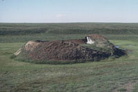
Collapsing pingo
© Parks Canada / 1988
When a pingo is growing, the ground stretches to accommodate its increasing surface area. The tundra splits apart in places, forming cracks – usually along the length of the pingo, especially near its summit – that may reach down as far as the ice core. If these cracks are large enough, the top of a pingo will resemble a crater. Sometimes water ponds in the crater, and this may begin to melt the ice core. More commonly, uplift of the sides of the pingo creates steep slopes that may become unstable and begin to erode. If the ice is exposed to the sun, the core will begin to melt. As its main support melts away, the pingo collapses.

Collapsed pingo
© Parks Canada
When the ice core has completely melted, all that remains is a doughnut-shaped ring of raised tundra enclosing a small round lake. In warmer regions, such as Ireland and the Netherlands, remnants of collapsed pingos have helped scientists determine that the climate was once cold enough in these areas to support a permafrost environment.
Source: http://www.pc.gc.ca/eng/docs/v-g/pingo/sec3/natcul1.aspx
And here is new video and pictures from the Siberian Times:


The hole is in the Yamalo-Nenets Autonomous, some 30 kilometres from the Bovanenkovo gas field. Pictures: Marya Zulinova, press service of the Governor YaNAO
More here: http://siberiantimes.com/science/casestudy/news/first-pictures-from-inside-the-crater-at-the-end-of-the-world/
UPDATE: A look at Google Earth for Yamalo-Nenets Autonomous reveals something like Minnesota’s Land-O-Lakes, but looks a lot like Land-O-Holes. See sat image:

Learn something new everyday! What a neat bit of information – and a process I’d never heard of before. Thanks Anthony! All the info, new pictures, video, and links to even more photos are great.
I don’t think this crater would be a big surprise to anyone who has seen quick sand that reaches quicking pore pressure and watched the water and air make tiny little craters like this one; or has worked in permafrost areas; or watched rocks get jacked out of the ground by ice lenses; or had to repound fence posts that are continually frost jacked out of the ground; or uncovered a moss covered mound to find a couple of metres of ice fed by ground water … oh, but then most folks don’t live in places that are frozen for 6 months of the year.
The scour in the hole is pretty amazing but the pressures that work in those conditions are also pretty amazing. I suspect there are some geotechnical people on this site that could give some numbers but soil, water and ice pressure variations go from 0 to huge and from huge to 0 very quickly in the right circumstances.
Great photographs. I hope there is some follow up on the stratigraphy of the hole.
Watching the British Open, I couldn’t help noticing the Royal Liverpool course is littered with these things.
I think that’s one of earths assholes…
The CSMonitor is recycling another batch of pingos as extraterrestrial in origin, or maybe global warming, but they’re keeping it kind of nebulous. “It’s an unexplainable mystery”, they say.