A couple of days ago I posted this story about the odd hole in the ground that appeared in Yamal, which was immediately blamed on ‘global warming’ by some fool who hadn’t looked at it closely:
Anna Kurchatova from the Sub-Arctic Scientific Research Centre, thinks the crater was formed by a mixture of water, salt and gas igniting an underground explosion, a result of global warming.
The most plausible explanation so far is a collapsed “pingo”, and these new pictures and video from the Siberian Times suggest it probably is. The pictures below from Parks Canada show similar structures in the process of collapse. For those that want to blame the collapse on “global warming” you might also note it is summer in Yamal, and melting ice is a regular and expected occurrence.
Here is what a pingo structure looks like in cross section:

Here is what Parks Canada has to say about them:
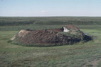
Collapsing pingo
© Parks Canada / 1988
When a pingo is growing, the ground stretches to accommodate its increasing surface area. The tundra splits apart in places, forming cracks – usually along the length of the pingo, especially near its summit – that may reach down as far as the ice core. If these cracks are large enough, the top of a pingo will resemble a crater. Sometimes water ponds in the crater, and this may begin to melt the ice core. More commonly, uplift of the sides of the pingo creates steep slopes that may become unstable and begin to erode. If the ice is exposed to the sun, the core will begin to melt. As its main support melts away, the pingo collapses.

Collapsed pingo
© Parks Canada
When the ice core has completely melted, all that remains is a doughnut-shaped ring of raised tundra enclosing a small round lake. In warmer regions, such as Ireland and the Netherlands, remnants of collapsed pingos have helped scientists determine that the climate was once cold enough in these areas to support a permafrost environment.
Source: http://www.pc.gc.ca/eng/docs/v-g/pingo/sec3/natcul1.aspx
And here is new video and pictures from the Siberian Times:


The hole is in the Yamalo-Nenets Autonomous, some 30 kilometres from the Bovanenkovo gas field. Pictures: Marya Zulinova, press service of the Governor YaNAO
More here: http://siberiantimes.com/science/casestudy/news/first-pictures-from-inside-the-crater-at-the-end-of-the-world/
UPDATE: A look at Google Earth for Yamalo-Nenets Autonomous reveals something like Minnesota’s Land-O-Lakes, but looks a lot like Land-O-Holes. See sat image:

If it appeared in just the last couple years how could it be linked to global warming? There has been no “global” warming for many years now as the UK Met Office, NASA, and UAH satellite all show:
http://www.cru.uea.ac.uk/cru/data/temperature/HadCRUT4.png
http://data.giss.nasa.gov/gistemp/graphs_v3/Fig.A.gif
http://nsstc.uah.edu/climate/2014/june2014/June2014graf.png
Local and regional warming, however, happens all the time. If it’s a pingo / hydrolaccolith / bulganniakh, then of course local or regional warming explains it. Alarmists conveniently mix up “global” and “local” warming (or sea level rise) to suit their whim just like they do with “climate” and “weather”. If you’re an alarmist, apparently you CAN have it both ways.
space aliens – obviously
Apparently, Australian climate researchers were seen uprooting a tree in the area not so long ago…
Ok…so was there ejecta or not? Is the stuff around the rim earth that had been raised by something underneath…and then when that something disappeared (like water dropping further downstream) it collapsed into the hole leaving a raised edge? Or did something eject out of it? It doesn’t look like there’s enough topside to have filled the entire hole. And if this JUST happened, there would be dirt on top of the ice at the bottom…there’s not. It’s shiney clear on the surface. So if it’s a sink hole…where did the crap that “sank” go?
Godzilla is on the rampage i am guess Mothra is coming to save the day, rejoice.
So it is a sink hole, but a special kind of sink hole called from a collapsing pingo. I learn something every day. Still…where is the hydrostatic water that seems to be required to build a pingo? We have a picture of the water at the bottom, but that is 200 feet down and it looks like there are dark recesses that may go deeper around the edges. Are Yamal lakes typically 200 feet deep? If not, is this something else?
I admit that I was wrong about the broken earth around the top being lower than the surrounding plane. There are definitely piles that are higher than the immediate country side, but if it is a pingo, there was no ‘ejection’. It is simply what is left of a collapsing mound. And there was certainly never any burning of the soil. The initial images did not support that idea at all.
I still think there is more to this pingo than meets the eye. I hope someone goes down in there and takes a look around.
I also wish we had the exact coordinates and could look at the area on Google Earth. ‘About 30 kilometers from that gas field’ is just not much of a clue! At least the articles could report which direction it is from the gas field!
It’s the ‘Horta’ from the original Star Trek series for cryin’ out loud.
Some Trekies you guys turned out to be.
You guys are not nerds.
Reblogged this on leclinton and commented:
Thank’s Antho-ney seen these in the territory’s Canada but never had a name for them till now ;>)
MASTER OF UNIVERSE says:
July 18, 2014 at 5:52 pm
These are not the droids your looking for move along now ;>)
All that is needed is a REALLY large tube of Clearasil….problem solved…(actually, truth stranger than fiction…just read that in Poland eight people got pulled into a quicksand hole…seven of them jumped in trying to rescue the first (if I read it correctly))…..whenever we think we know it all, nature comes up with something new….be careful out there, folks….
Greg says:
July 18, 2014 at 8:02 am
In Canada and around the north we call it Tundra mostly dead moss “liken” and some rocks left there glacier drop of from the melt back , and 1 meter of permma frost . I have seen these all over the north when there is a higher water source ;>)
classicalhero7 says:
July 18, 2014 at 2:03 pm
Someone should do a macro of Christophe Waltz in Inglorious Basterds saying “That’s a Pingo!”
Don’t know why you made me laugh so hard but the picture in my mind was jolting.
Hi Love this post ,
I like this website very much so much excellent info.
thank you for posting .
This new footage provides some essential new information. We are clearly located on the Siberain tundra, with marshes, thermocarsts, and plenty of sub-surface methane. Judging from the debris around this crater, it has erupted several times before. Thus, it probably has an unknown history of annual or bi-annual eruption, just like a mud volcano. However, the pipe leading down to the water is pretty deep (perhaps 30m?). This means that the erupting methane, probably has had an overburden of material that is 30 m thick. It means that the reservoir of gas has to build up a pressure greater than the overburden pressure before it erupts. The eruption of this pingo-like structure is, however not very dramatic, as it does not necessarily ignite (like most mud volcanic eruptions do – se the Lokbatan eruption in Baku, some years ago).
My conclusion is that this is a local pressure release crater, much like submarine pockmarks, in the world’s oceans and lakes. They are very rare on land (in Norway, there is only one known occurrence of a marsh hole caused by methane blowout, but much smaller than this one).
It probably is a collapsed crater of any extinct volcano or …… just a sink hole.
So hemispheric warming rather than global. I’m surprised that isn’t blamed on “carbon pollution”.
Pingos used to cause havoc.
Notice the shrubby vegetation around the sides of the crater but not farther away–the raised area provides drainage that allows plants to grow better than in the nearby water-logged soils.
But are there pingos on Mars?
http://apod.nasa.gov/apod/ap140309.html
http://news.nationalgeographic.com/news/2010/12/photogalleries/101221-mars-pits-pictures-photos-science-nasa-space-caves/
“Anna Kurchatova from the Sub-Arctic Scientific Research Centre…” ‘Sub-Arctic’ and she doesn’t know what a pingo is!!! What doesn’t the researcher know about the tundra? I think a few years in a Siberian gulag would help her understand.
MASTER OF UNIVERSE says:
July 18, 2014 at 5:52 pm
It’s the ‘Horta’ from the original Star Trek series for cryin’ out loud.
Looks more like a Sarlacc pit to me.
@jim Clarke at 7/18 5:24 pm
There are definitely piles that are higher than the immediate country side, but if it is a pingo, there was no ‘ejection’. It is simply what is left of a collapsing mound. And there was certainly never any burning of the soil. The initial images did not support that idea at all.
Change your timescale. This was a vertical glacier that moved upwards at a slow pace. It is an artesian spring that freezes down through permafrost. Hydrostatic forces push the plug slowly upward, “ejecting” ice and rock upwards at rates of mm/day. It may have grown for hundreds or thousands of years. Look at the surface photos. There is one creek that radiates away from the hole. That drains away the water from the extruded ice as it melts in the summer.
What happened in the past couple years is the artesian spring has stopped. The ground water table has dropped by maybe 200 ft. That stops the growth of the ice core. It allows the core to melt, collapse, lose it’s soil cap insulation, and melt faster in the summer.
Why has the ground water forces changed? Could it be a change in a pingo down slope? Has it anything to do with the development of a supergiant gas field on the horizon? For instance, are they using water injection for pressure maintenance in the field and if so, where are they getting the water year round? Did they have an artesian blowout in drilling before surface casing? The time, place, and the magnitude of the change makes me suspect the gas field development has something to do with the evolution of the hole left by a melted pingo.
Notice how there isn’t a single Nauga (the source of Naugahyde) any more.
It’s this hole …
“When the ice core has completely melted, all that remains is a doughnut-shaped ring of raised tundra enclosing a small round lake.” Where’s the lake, where’s the ground water to cause the pingo?
My experience with Pingo type structures, is that they are extremely dangerous during their initial stages. During the summer melt they are like an icy, partly water filled cavern, right below the surface of the tundra. Walking alone in the tundra and falling through the vegetation covering the cavern, is generally fatal. These structures have other names in other places and are the source of some sad tales. Pingo may not be the correct name for the small ones in English.