A couple of days ago I posted this story about the odd hole in the ground that appeared in Yamal, which was immediately blamed on ‘global warming’ by some fool who hadn’t looked at it closely:
Anna Kurchatova from the Sub-Arctic Scientific Research Centre, thinks the crater was formed by a mixture of water, salt and gas igniting an underground explosion, a result of global warming.
The most plausible explanation so far is a collapsed “pingo”, and these new pictures and video from the Siberian Times suggest it probably is. The pictures below from Parks Canada show similar structures in the process of collapse. For those that want to blame the collapse on “global warming” you might also note it is summer in Yamal, and melting ice is a regular and expected occurrence.
Here is what a pingo structure looks like in cross section:

Here is what Parks Canada has to say about them:
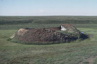
Collapsing pingo
© Parks Canada / 1988
When a pingo is growing, the ground stretches to accommodate its increasing surface area. The tundra splits apart in places, forming cracks – usually along the length of the pingo, especially near its summit – that may reach down as far as the ice core. If these cracks are large enough, the top of a pingo will resemble a crater. Sometimes water ponds in the crater, and this may begin to melt the ice core. More commonly, uplift of the sides of the pingo creates steep slopes that may become unstable and begin to erode. If the ice is exposed to the sun, the core will begin to melt. As its main support melts away, the pingo collapses.

Collapsed pingo
© Parks Canada
When the ice core has completely melted, all that remains is a doughnut-shaped ring of raised tundra enclosing a small round lake. In warmer regions, such as Ireland and the Netherlands, remnants of collapsed pingos have helped scientists determine that the climate was once cold enough in these areas to support a permafrost environment.
Source: http://www.pc.gc.ca/eng/docs/v-g/pingo/sec3/natcul1.aspx
And here is new video and pictures from the Siberian Times:


The hole is in the Yamalo-Nenets Autonomous, some 30 kilometres from the Bovanenkovo gas field. Pictures: Marya Zulinova, press service of the Governor YaNAO
More here: http://siberiantimes.com/science/casestudy/news/first-pictures-from-inside-the-crater-at-the-end-of-the-world/
UPDATE: A look at Google Earth for Yamalo-Nenets Autonomous reveals something like Minnesota’s Land-O-Lakes, but looks a lot like Land-O-Holes. See sat image:

I’m trying to find a reference site that shows temperature data for the Yamal Peninsula going back a few decades. Does anyone know where I can find one? Google searches turn up lots of articles from places like The Guardian and other useless alarmism, I’d like to see the raw(ish) data.
don’t know what this is about. you figure. I probably don’t care
Yamal was also the home of that freak tree whose rings became the basis for the infamous hockey stick. I wonder if anyone has investigated the possibility that Yamal tree rings respond to nearby pingos. It might help explain the freak tree.
“The researchers were unable to make their way to the bottom of the lake, but did go inside the crater.
‘There is ice inside the crater which gradually thaws under the sun.
‘Also there is melted water flowing down from its sides, you can see water traces on the pictures. The crater is filled with ice by about eighty per cent. ‘
He stressed: ‘We are working with space photographs to figure out exact time of its formation.
‘We have taken soil and ice samples which went straight to laboratories. We can be certain in saying that the crater appeared relatively recently, perhaps a year or two ago; so it is a recent formation, we are not talking about dozen years ago.
‘Could it be linked to the global warming? We have to continue our research to answer this question.
‘Two previous summers – years 2012 and 2013 were relatively hot for Yamal, perhaps this has somehow influenced the formation of the crater.
‘But we have to do our tests and research first and then say it more definitively’.
My expertise on pingos consists of reading what Anthony posted and what is on Wikipedia (I had never heard of them before 20 minutes ago), so maybe my opinion is the result of ignorance, but I don’t think it’s a pingo. The news article describes the hole as being about 30 meters wide and 70 meters deep, and the pictures show a relatively small rim of material on the surface. Based on the brief descriptions and photos of known pingos, I would have expected a more shallow depth to width ratio with more material on the rim. Maybe somebody can find some more information to disprove me.
Also, it appears to me that there is a shallow stream bed leading to the hole, but none leading away from the hole, as though it was acting like a drain.
A “pingo.” That’s actually pretty cool. 🙂
According to the top diagram, this is a spring that freezes solid and deep. One of the pictures shows a creek bed leaving the hole as it’s origin.
Frost heave on a large scale.
I got to thinking that the forces might be similar to a mud volcano.
Aha!
This is a vertical glacier!
An ice plug forms in the winter, but hydrologic forces cause the plug to rises slowly, scraping and smoothing the walls, as water fills in below to freeze again.
The only fly in the ointment is that currently the water table is very low. At present, the thing is NOT a SPRING. Something changed to lower the water table, perhaps another pingo down slope.
Mosh:
Could it be linked to the global warming? We have to continue our research to answer this question. Two previous summers – years 2012 and 2013 were relatively hot for Yamal, perhaps this has somehow influenced the formation of the crater. Perhaps it reached its tipping point a fraction of a second earlier than it might have done without our carbon-forcing. Although the landscape implies that this kind of event is frequent and mundane, we think this time it might be special. But we have to do our tests and research first and then say it more definitively. Until then, keep worrying.
No the planets got zits!
James Bull
So.. how do we know it is not a meteorite crater?
To me it looks like a huge sink-hole.
Spatial distribution of pingos in northern Asia
http://www.the-cryosphere.net/5/13/2011/tc-5-13-2011.pdf (8 MB)
Fig. 5.Spatial point density of pingo locations using a 20×20 km search window (400 km2) and 5 km grid cell size. Histogram shows pingo distribution by geographical latitude. Black outline in this and subsequent figures indicates the study area boundary
The map covers from 60 E to 170 W across all of Siberia. Pingos are mapped from 61 N to 74 N.
Over 1620 pingos mapped.
Table 4: Pingo Density. Yamal is less than 13 / 100 km^2
The Wikipedia article on “Thermokarst” is a good source for references to other arctic, periglacial, and permafrost landform types and vocabulary.
Pingos are true perennial permafrost mounds. It is generally accepted that there are two main types of pingos in terms of genesis: hydrostatic (closed system) and hydraulic (open system). It is here proposed that a third category of ‘polygenetic’ (or ‘mixed’) pingos should also be recognized in the light of published work and recent investigations. The lack of comprehension of hydraulic pingo genesis would seem to add weight to this proposal. Since suitable conditions for the formation of pure hydrostatic pingos are rarely met outside the Mackenzie Delta/Tuktoyaktuk Peninsula area the ‘world’ type of pingo is most likely to be of an hydraulic or ‘polygenetic’ variety and thus further investigation is warranted, particularly for the elucidation of the palaeoenvironmental inferences of ‘relict pingos’.
http://www.aina.ucalgary.ca/scripts/minisa.dll/157/1/0?SEARCH
I have been anxiously awaiting Keith Briffa’s new book: “A Tree Grows in Yamal”.
Perhaps he is already working on the sequel: “A Pingo Grows in Yamal”
(sarc off)
Temperature data for Yamal can be found at http://met.no/filestore/Ealat_Yamal_climaterep_dvs-1.pdf
Kwar
“Until then, keep worrying.”
huh. I’m not worried about global warming. not one bit.
I just note people’s lack of skepticism and their rush to judgment about everything remotely related to their cherished beliefs.
good skeptics say.. we need to look more closely, pingo bingo
Related…..ice wedge polygons.
Did Kevin check it for his missing heat?
Looks pretty warm inside that hole.
cn
Reminds me of working on top of an old landfill. The gases from all the decaying garbage would build up beneath the surface and during wet weather, there’d be these little mounds of upheaved turf that would develop, some to about a meter in height. They could be popped with a pick or just let be.
GaryB says:
July 18, 2014 at 9:21 am
In southern New England where the freeze-thaw cycle repeats often in the winter, we call these thing potholes.
======================================
Frost heaves. Bang!!! Damn!! Trick is to watch for chunks of ice along the side of the road from where the ice has broken off of the wheel wells of the previous victims of the FH.
looks just like the earthworm holes I see in the driveway after a rain storm (bigger of course) I say a giant prehistoric earth worm popped up for a look didn’t like what he seen and went back to sleep ;0)
It appears to be an artesian spring that froze then thawed. So they’re not just for making beer anymore. http://en.wikipedia.org/wiki/Olympia_Brewing_Company#Use_of_Artesian_water
Someone should do a macro of Christophe Waltz in Inglorious Basterds saying “That’s a Pingo!”
That looks like a sink-hole. Around here, water underground + limestone = sink-hole as the water contains acids naturally strong enough to dissolve the calcium carbonate (or in the case of dolomite sink-holes, magnesium carbonate). Ah so a major ‘frost-heave’ followed by a collapse when the water flows away does the same thing.
This hole was caused by YAD 061, the ‘warm’ tree that caused Al Gore’s hockey stick. This tree eventually got so hot, it burned a hole through the permafrost.
/sarc