Remote. Cold. Rugged. Those three adjectives capture the essence of Russia’s Kamchatka Peninsula. Another word—perhaps more applicable than anywhere else on Earth—is “fiery.”
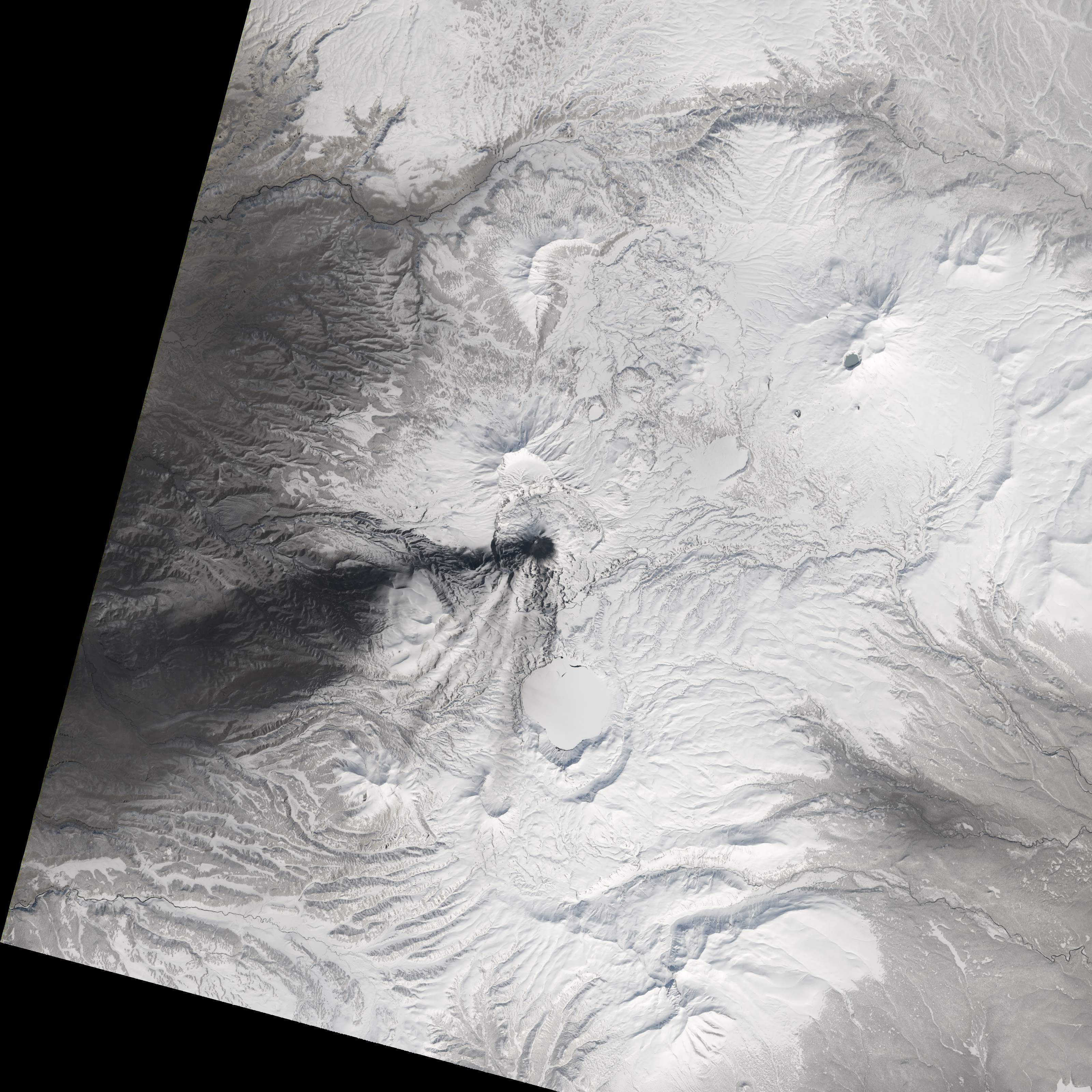
Of the roughly 1,550 volcanoes that have erupted in the recent geologic past, 113 are found on Kamchatka. Forty Kamchatkan volcanoes are “active,” either erupting now or capable of erupting on short notice. The Operational Land Imager (OLI) on Landsat 8 captured activity at five of them during a single satellite pass on April 14, 2014.
Imagery follows.
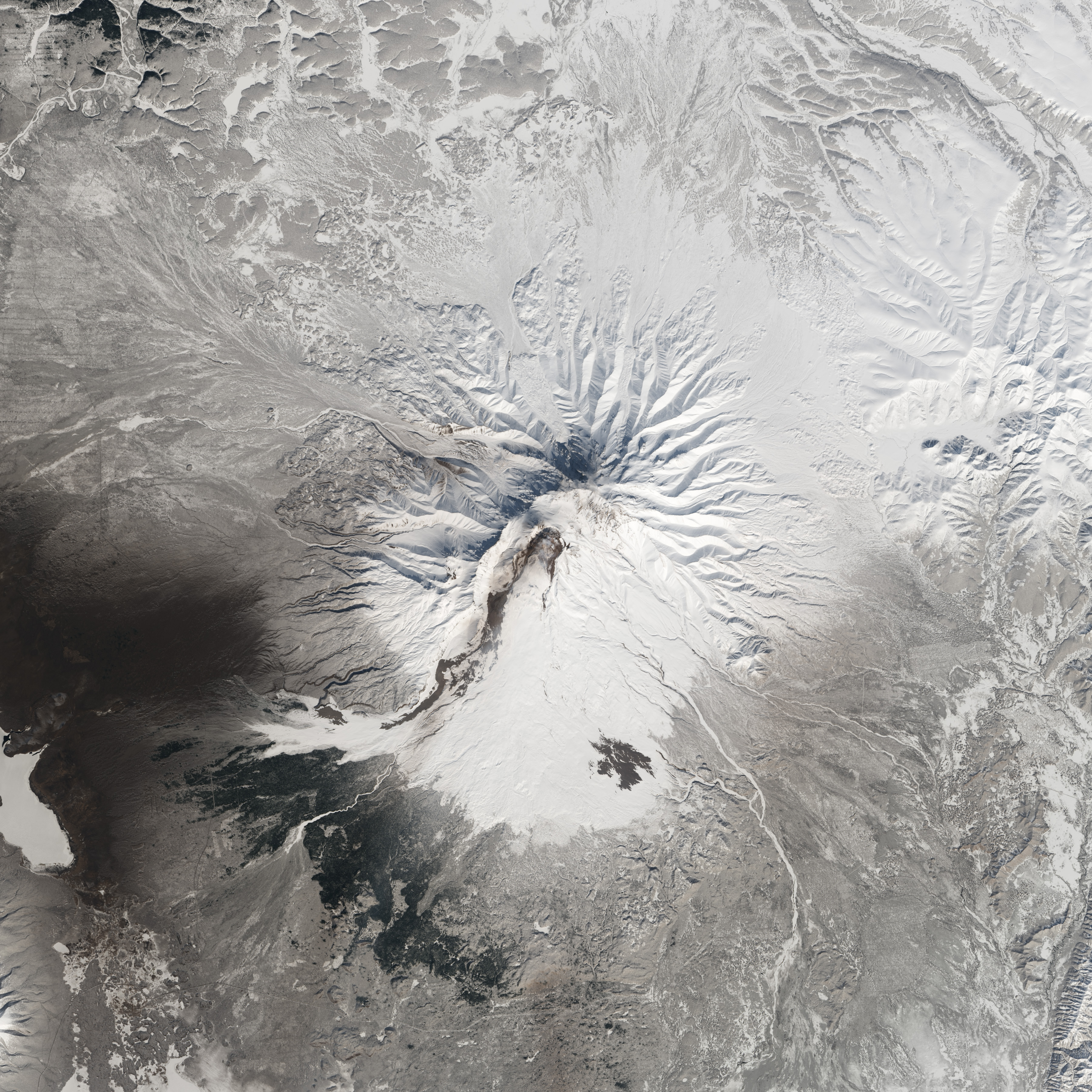
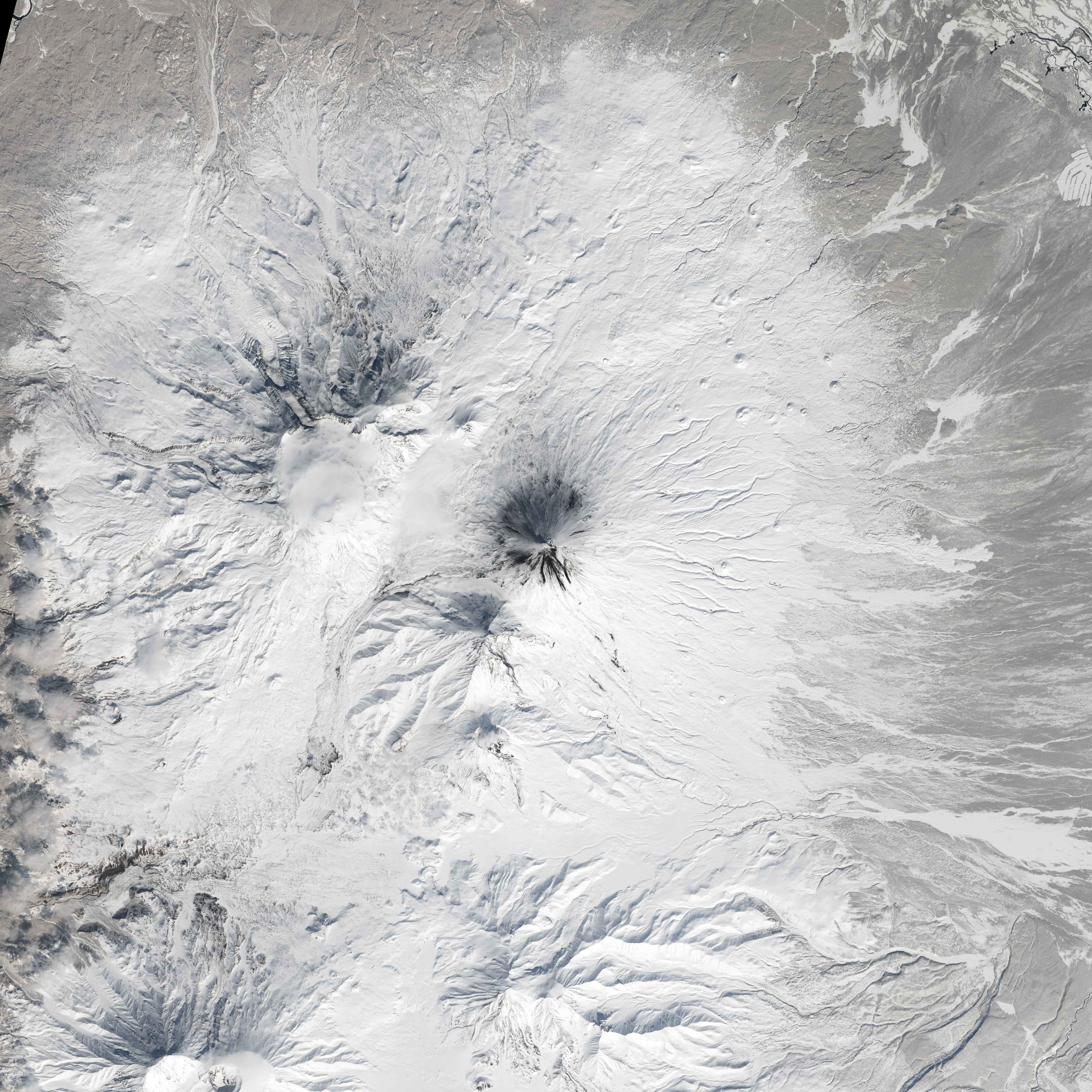
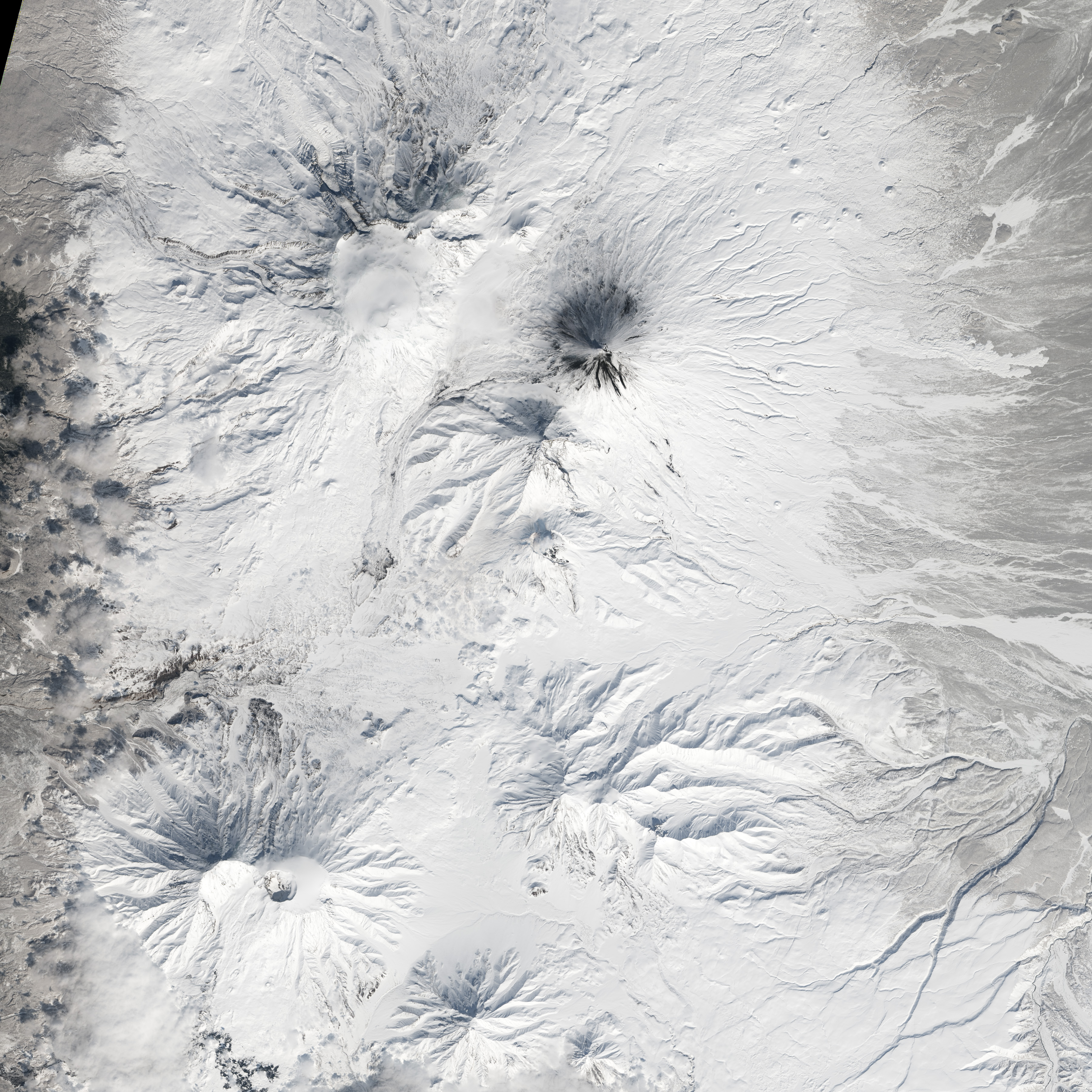
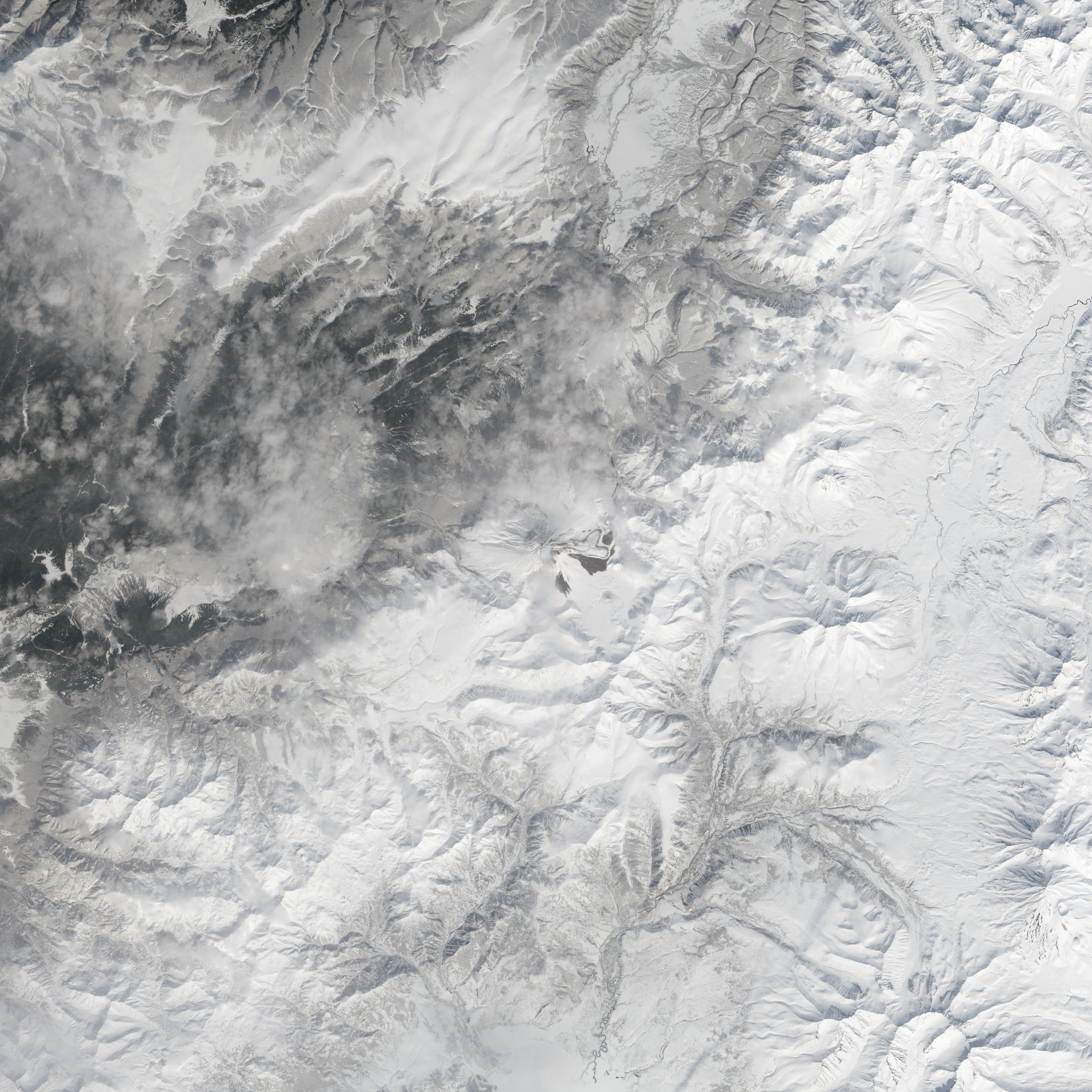
From geographic north to south (and top to bottom on this page), the volcanoes are Shiveluch, Klyuchevskaya, Bezymianny, Kizimen, and Karymsky. The tallest of the group is Klyuchevskaya, a stratovolcano with a steep, symmetrical cone that reaches 4,750 meters (15,580 feet) above sea level. The most active is Karymsky, a 1,536-meter (5,039-foot) peak that has erupted regularly since 1996.


Plate tectonics is responsible for the many volcanoes on Kamchatka Peninsula. The Pacific Plate is slowly colliding with and sliding beneath the Okhotsk Plate. As rock from the Pacific Plate descends and encounters higher pressures and temperatures, it melts into magma. Over time, magma accumulates and migrates up toward the surface, causing volcanic eruptions.
Long before the discovery of plate tectonics, Kamchatka’s many volcanoes and eruptions were woven into a rich tapestry of myths and creation stories. According to Koryak folklore, the raven-like deity Kutkh created Kamchatka by dropping a giant feather on the Pacific Ocean. Each of the first generation of men became one of Kamchatka’s mountains at death; many of these mountains became volcanic because the men’s hearts burned so passionately for a beautiful woman that Kutkh had also created near the beginning of time.
In 2013, another NASA satellite collected imagery of Shiveluch, Bezymianny, Tolbachik, and Kizimen.
Story from NASA’s Earth Observatory
-
References and Related Reading
- Earth Observatory Activity at Kliuchevskoi.
- Earth Observatory Kamchatka Volcanoes.
- Global Volcanism Program Kamchatka and Mainland Asia. Accessed April 15, 2014.
- Kamchatka Volcanic Eruption Response Team Kamchatka and the Norther Kuriles Volcanoes. Accessed April 15, 2014.
- PBS The Ring of Fire. Accessed April 15, 2014.
- Volcano World Volcano Folklore: Russia. Accessed April 15, 2014.
We live in very interesting times. Even a plate tectonics is cited over and over again (as here) to explain geological phenomena, modern seismology is systematically kicking the wooden leg from beneath the operative mechanism. Instead of reasonable mantle convection we have LLSVP’s, mutant root canals from the core that do not support the system of ocean spreading ridges.
http://geosciencebigpicture.com/2014/04/13/doughboys/
Alas, we must begin to seriously consider electromagnetic models in geology. What moves rocks can all the more easily move air. The ring currents are terra and aire incognita.
One volcano name is actually not a name at all:
Bez is ‘without’, imya is ‘name’. The suffix provides the tense. Maybe we can ask the Russians to name it Вулкан Гор, that is, Volcano Gore after one of the biggest blowhards we know. The Russians might also like it because Al’s daddy was bought and paid for by Armand Hammer, a USSR supporter and likely soviet agent doing business as so-called citizen diplomacy(http://english.pravda.ru/history/23-05-2012/121214-armand_hammer_soviet_union-0/ and http://www.theforbiddenknowledge.com/hardtruth/armand_hammer.htm).
I am seeking some help/assistance from a volcanologist. I live in New Zealand, Mount Taranaki sits about 5km from us. Geonet.co.nz gives information on New Zealand’s volcanoes and under Mount Taranaki/Mount Egmont the RSAM and SSAM data is showing signs of volcanic Tremors. A volcanologist from Geonet has said it is due to bad weather but would like a second opinion. Any takers?
Could this be the evil illuminati using HAARP to destroy Russia over the Ukraine-thing-ame-bobby? [/sarc]
, Greg Goodman says:
April 16, 2014 at 12:34 pm
If my hypothesis that El Nino is a manifestation of slow subsurface tidal effects on the thermocline there may be stronger El Nino build up next year as the eclipses move even closer to coinciding with the equinox.
These eclipse patterns repeat almost identically every 18 calendar years and 10 or 11 days. 18 y from 1998 would be 2016.
=====================================
If there is anything in your hypothesis, it should have shown up in 1980, 1962, 1944 etc. Did it?
Volcanoes are the largest natural producer of CO2. Our 3% is nothing in comparison.
Mr Green Genes says:
April 17, 2014 at 1:31 am
Greg Goodman says:
April 16, 2014 at 12:34 pm
If my hypothesis that El Nino is a manifestation of slow subsurface tidal effects on the thermocline there may be stronger El Nino build up next year as the eclipses move even closer to coinciding with the equinox.
=====================================
If there is anything in your hypothesis, it should have shown up in 1980, 1962, 1944 etc. Did it?
…………………
Greg may well be correct, I also think it is a sub-surface factor, however I think it comes from the seafloor tectonics, there were some strong EQs there few days ago and that may be a trigger for next fluctuation, but I have not updated the graph (see here ) for some time now.
RACookPE1978 says:
April 16, 2014 at 11:04 am
bushbunny says:
April 16, 2014 at 7:17 pm
I have been looking up the volcanoes activity at http://www.volcano.si.edu/
Karymsky does not seem to have done much, but Shiveluch had several VEI ?3 events from July 2013 to Feb 2014. I don’t know if any of this ash has made it to the stratosphere to produce stratospheric warming over Alaska and Canada.
Joel O’Bryan says:
April 16, 2014 at 11:18 am
There seem to have been 4 eruption events VEI 5 or greater during the satelite temperature measurement period, Mt St Helens, El Chichon, Pinatubo and ?Kelud.
I have not worked out how to look at the daily satellite stratospheric temperature records to see if there is any effect from Kelud.
Here’s my theory on how CO2 is to blame for the volcanic activity. As the CO2 increases, the atmosphere weighs more, and this increase in weight causes shifts in the rock strata, allowing magma to move easier and volcanoes to erupt.
Additionally, this increase in weight is transferred to the oceans as energy, and it forces the heat generated by this increased pressure to sink to the bottom of the ocean, taking excess solar heat with it.
Makes sense, right? 😉 Should I apply for a grant to validate my idea?
Go ahead, lesser beings have been successful. LOL