Anyone who visits the Unisys sea surface temperature anomaly webpage will have noted the recent cool sea surface temperature anomalies off the southwest coast of Europe. Since the map on their main page is updated daily, I’ve presented the most recent map in their archive as Figure 1.
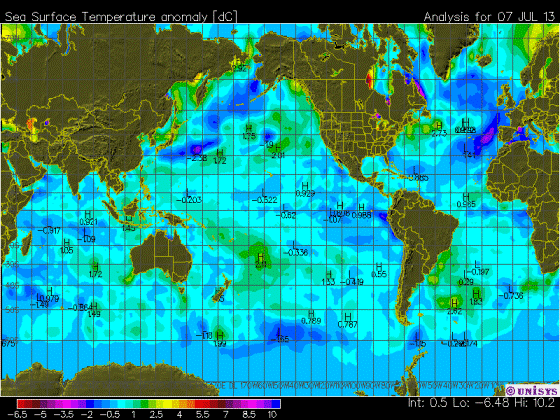
Figure 1
The direct link to that archived map is here.
The color-coding of the Unisys maps of course makes the data appear cool, but even so, the June 2013 sea surface temperature anomalies, based on the Reynolds OI.v2 data, are in fact cool off the southwest coast of Europe. As shown in Figure 2, the data for the coordinates of 35N-55N, 20W-5E haven’t been that cool since 1993-94.

Figure 2
But—there’s always a but—the sea surface temperature anomalies to the north and northwest of Europe (55N-75N, 20W-55E) are running on the warm side. Refer to Figure 3.

Figure 3
As a whole, though, the sea surface temperature anomalies for European coastal waters are pretty typical of the values for the last decade, as shown in Figure 4.

Figure 4
And of course, there’s nothing in the ocean heat content data and the satellite-era sea surface temperatures to indicate that manmade greenhouse gases were responsible for the warming of the global oceans. If that topic is new to you, refer to the illustrated essay “The Manmade Global Warming Challenge”.
A COUPLE OF CLOSING QUESTIONS
Figure 5 is a map that captures the June 2013 sea surface temperature anomalies for the portions of the Arctic Ocean, Mediterranean Sea and North Atlantic discussed in this post. While the warm anomalies at high latitudes are likely the result of a weather pattern, it almost appears as though Iceland is somehow responsible for part of the warming.

Figure 5
And that leads to my questions:
Has anyone ever seen a study of the impacts of volcanic ash and pumice on the optical properties of sea water and/or on sea surface temperatures? And has anyone seen a study of the impacts of volcanic ash from recent high-latitude eruptions on the albedo of sea ice?
SOURCES
The Sea Surface Temperature anomaly data used in this post is available through the NOAA NOMADS website:
http://nomad1.ncep.noaa.gov/cgi-bin/pdisp_sst.sh
or:
http://nomad3.ncep.noaa.gov/cgi-bin/pdisp_sst.sh?lite=
Isn’t the Iceland anomaly just the Gulf stream but it then leads to the question what is different this year vs past years?
The hot spot in Hudson bay north of Churchill Manitoba is a puzzler and one that warrants further examination since my first guess would be that river discharge temps are being compared to sea water temps somehow … likely changes in sampling points which yield yet another “its worse than we thought” alarmist data point 😉
“But, but – look at the anomaly off Manitoba / Nunavut! There’s the proof of CAGW right there! In fact, it’s worse than we thought! Soon we’ll have palm trees growing there and coral reefs in Hudson Bay!”
Actually, that is easily explained – the temperature anomaly is due the unexpectedly large population of polar bears (versus the warmists’ predictions) urinating in Hudson Bay during their summer vacations. 😉
Catcracking says: “Given the temperature anomalies shown for the Atlantic, I am confused as the hurricane predictions based on claimed higher ocean temperatures. Possibly you can clarify this, Bob.”
I didn’t notice this year if the predictions of an above-normal hurricane season were based on higher sea surface temperatures, but sea surface temperature anomalies are still a little above normal in the Main Development Region (10N-20N, 80W-20W):
http://i42.tinypic.com/fxs579.jpg
They’ve dropped a little since my last full post about the sea surface temperatures and anomalies of the hurricane development regions:
http://bobtisdale.wordpress.com/2013/05/19/hurricane-main-development-region-sea-surface-temperatures-anomalies-plus-a-couple-of-other-regions/
The factor that I know was mentioned in the prediction of an above-average hurricane season was that we weren’t expecting an El Nino to form this season, and we still aren’t. El Ninos in the tropical Pacific suppress hurricane formation in the tropical North Atlantic. So the absence of an El Nino would contribute to the higher number of hurricanes predicted.
Regards
The higher ocean temperatures, not CO2, in the Arctic region would account for more ice melting there.
This colder water off the coast of Europe may explain why AMO has been dropping since November 2012 at 0.484 to 0.079 in June 2013
Keep in mind what is not visible. There is continuing unusual polar atmospheric flow, eg. with reversed wind directions from usual. Given wind affected water flow tends to 90 degrees from the intuitive direction (Coriolis) maybe this is at work.
Over the past week a huge great storm has passed between Iceland and Scotland/Norwegian coast on it’s way north east, might be related.
I spotted another plummet in data which is totally unconnected but put it down to error or just an oddity to be considered sometime.
Bob,
Thanks for the clarification.
Here are several links that discuss hurricane for 2013 due to warmer ocean temperatures which must be the basis for my perception..
Probably not reliable sources (CNN)
http://www.cnn.com/2013/05/23/us/hurricanes-prediction
http://www.climatenewsnetwork.net/2013/05/hurricane-warning-is-linked-to-climate/
Peter Dunford says:
July 13, 2013 at 6:11 am
“The centre of the north icelandic hot spot is right over the where the mid-atlantic plates are pulling apart. Perhaps magma close to the surface is warming the water there, from below.”
Lots of tectonic activity offshore north Iceland back in April.
http://www.jonfr.com/volcano/?p=3591
herkimer says: “This colder water off the coast of Europe may explain why AMO has been dropping since November 2012 at 0.484 to 0.079 in June 2013”
The peak in the North Atlantic sea surface temperature anomalies last November…
http://bobtisdale.files.wordpress.com/2013/07/07-no-atl.png
… was likely the result of the short-term El Niño conditions earlier last year:
http://bobtisdale.files.wordpress.com/2013/07/02-nino3-4.png
Regards
This is excellent news – we are planning a tour by river boat from Europe to the Caspian Sea and the last thing we need to see is a projection of miserable cold. At least I hope that is what the colors mean. I don’t think I’ve ever seen a color map wrap around quite like this one does. Can I get a second opinion?
l see this fine weather we have been having in the UK over the last week has started to warm the waters around the UK. This helps to confirm what l have seen else where. That the local weather can have a real impact on sea surface temps.
mwhite says: July 13, 2013 at 6:27 am
“UNISYS Current Sea Surface Temperature Anomaly Plot”
http://wattsupwiththat.com/reference-pages/climatic-phenomena-pages/enso/
Why the two maps?????????
They are just two versions, Bob is using the original version;
http://weather.unisys.com/surface/sst_anom.gif
whereas on the ENSO page we use the “new” version:
http://weather.unisys.com/surface/sst_anom_new.gif
The “new” version makes things look warmer, and lost a bit of the finer detail the original affords, but as James Cross says: July 13, 2013 at 5:53 am notes, the original version has a “Very confusing color scheme.”
In the Netherlands we have had 6 consecutive months with temperatures below normal, thanks to the cold North Sea. Please tell me that this is just noise in the climate system and that the expected warming will soon continue. 😉
Thanks, Bob. Good post. This chaotic weather!
Also:
The Tropical Meteorology Project
(Dr. Philip J. Klotzbach, Dr. William M. Gray, Colorado State University)
Extended Range Forecast of Atlantic Seasonal Hurricane Activity and U.S. Landfall Strike Probability for 2013 (.pdf, June 3 ’13):
We continue to foresee a very active 2013 Atlantic hurricane season. The tropical Atlantic remains very warm, and we do not anticipate development of a significant El Niño. Given the above-average forecast, we are calling for an above-average probability of United States and Caribbean major hurricane landfall.
See http://hurricane.atmos.colostate.edu/Forecasts/2013/apr2013/apr2013.pdf
The Polar Front is normally just north of Iceland. If it retreats a few hundred kilometers the result will look like a narrow swath of strong warming.
By watching the fulldisk satellite images,what looks to be the reasons for the current low hurricane activity. ls the east to west airflow across the mid Atlantic looks to have become rather weak and waving. lts this that seems to be making it hard for hurricanes to form. Also the heavy rain along the eastern side of the USA this summer has taken a lot of the heat out of the waters around Cuba and the SE of the USA.
I think underwater volcanoes do play a part, maybe small, in the sea ice shrinkage in the Arctic. The obvious one has to be off of Thule, Greenland (far north west). Also, it looks like there is one northwest of the Svalbard islands (Longyearbyen side). Thule in particular will have heavy sea ice north and south of it but open water for some time. Maybe their is a warm river due to geothermal activity nearby.
There has been an incredible warm spell on northern europe this summer, which propably explains the warm ocean east of Iceland.
The color scheme of the first graph almost looks as if they didn’t expect there to be cold anomalies anymore…
Has anyone ever seen a study of the impacts of volcanic ash and pumice on the optical properties of sea water and/or on sea surface temperatures? And has anyone seen a study of the impacts of volcanic ash from recent high-latitude eruptions on the albedo of sea ice?
Pumice is light coloured and floats for a period. Clearly it will have a large albedo effect, until it sinks. I don’t recall any reports of pumice off Iceland, and it would take a lot to affect SSTs.
The north south SST anomaly differences are due to recent weather patterns. That they start east of Iceland is probably just a coincidence. Note the warm anomalies in the shallow Baltic and in the shallow seas around the Kola Peninsula. This indicates above average sunshine is the cause.
Have you seen this article?
http://oceanrep.geomar.de/4684/
The role of airborne volcanic ash for the surface ocean biogeochemical iron-cycle: a review
Abstract
Iron is a key micronutrient for phytoplankton growth in the surface ocean. Yet the significance of volcanism for the marine biogeochemical iron-cycle is poorly constrained. Recent studies, however, suggest that offshore deposition of airborne ash from volcanic eruptions is a way to inject significant amounts of bio-available iron into the surface ocean. Volcanic ash may be transported up to several tens of kilometers high into the atmosphere during large-scale eruptions and fine ash may stay aloft for days to weeks, thereby reaching even the remotest and most iron-starved oceanic regions. Scientific ocean drilling demonstrates that volcanic ash layers and dispersed ash particles are frequently found in marine sediments and that therefore volcanic ash deposition and iron-injection into the oceans took place throughout much of the Earth’s history. Natural evidence and the data now available from geochemical and biological experiments and satellite techniques suggest that volcanic ash is a so far underestimated source for iron in the surface ocean, possibly of similar importance as aeolian dust. Here we summarise the development of and the knowledge in this fairly young research field. The paper covers a wide range of chemical and biological issues and we make recommendations for future directions in these areas. The review paper may thus be helpful to improve our understanding of the role of volcanic ash for the marine biogeochemical iron-cycle, marine primary productivity and the ocean-atmosphere exchange of CO2 and other gases relevant for climate in the Earth’s history.
Looks like ash as fertilizer is the hot new research area:
http://www.atmos-chem-phys.net/10/3891/2010/acp-10-3891-2010.pdf
[…]it almost appears as though Iceland is somehow responsible for part of the warming.
Let’s hope not. Iceland sending out a huge plume of warm water can’t be a good sign.
taxed says: “By watching the fulldisk satellite images,what looks to be the reasons for the current low hurricane activity.”
We’ve had three named storms storm so far this year, and that’s outpacing an average (1966-2009 base) year.
Graph:
http://www.nhc.noaa.gov/climo/images/cum-average_Atl_1966-2009.gif
From this webpage:
http://www.nhc.noaa.gov/climo/
Regards
“There has been an incredible warm spell on northern europe this summer, which propably explains the warm ocean east of Iceland.”
I suspect Hannuko lives in Finland, a bit further west in Norway-Sweden it has been a quite average summer so far.
@ur momisugly Bob Tisdale
The three storms we have had so far have been TS rather then hurricanes.
Now don’t get wrong am not saying there is no risk of storms forming. Just that if the current conditions in the mid Atlantic stay in place. Then the risk of large hurricanes forming in the mid Atlantic will remain low.