By Joseph D’Aleo, CCM
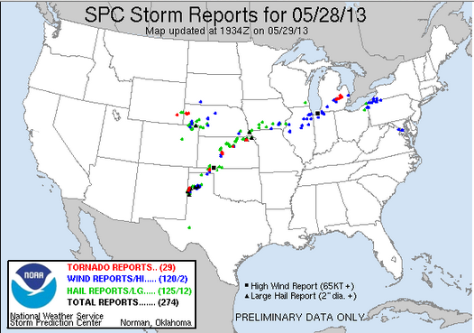
Tuesday was an active severe weather day with 29 reported tornadoes (preliminary).

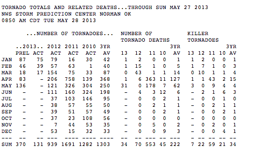
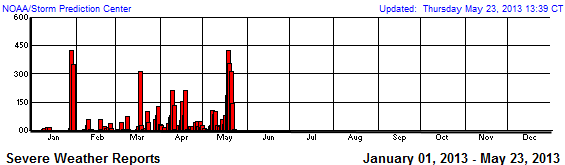
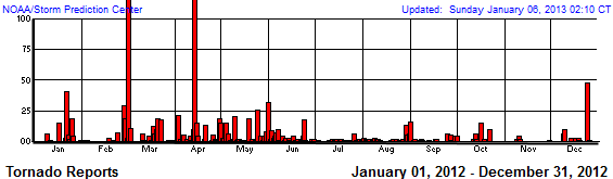
But for the season thus far, we are at the bottom end of the frequency as of the date. When it was active in 2011, the ignorant and opportunists blamed it on global warming. Last spring was very warm and activity was way down. This year, spring ranked among the coldest and activity was very low and only recently has picked up as warmth finally began pushing north to clash with the colder air to the north.
It is in the region of CONTRAST that the jet stream is energized and severe weather occurs. When it is too warm or too cold from north to south, activity is depressed. Global warming would diminish the contrast north to south and result in weaker storms, a weaker jet stream, fewer tornado outbreak and strong EF3-5 tornadoes.


We are passing the peak of the severe weather season. The delayed shift north of the jet stream and alternating cooler and warmer weather will allow for some catch up.

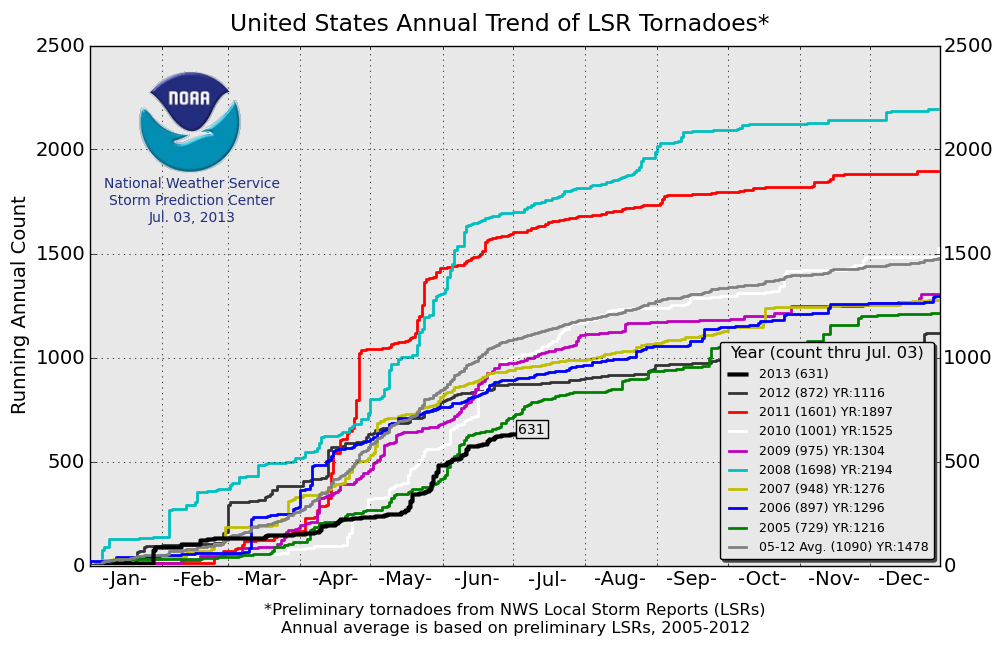
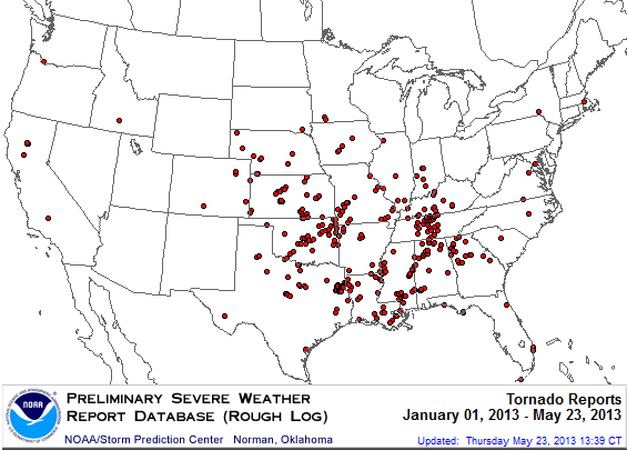
See the activity year to date this year


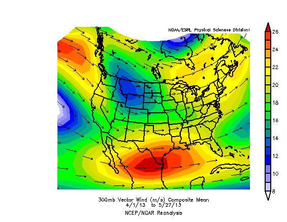
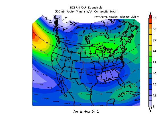
See how suppressed the 300mb jet stream has been on average.

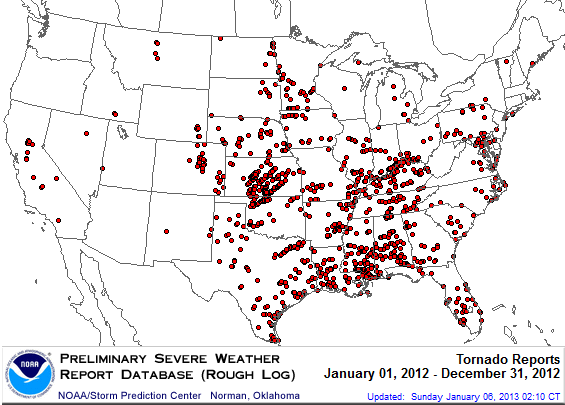
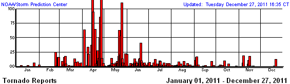
See the activity last year (whole year).


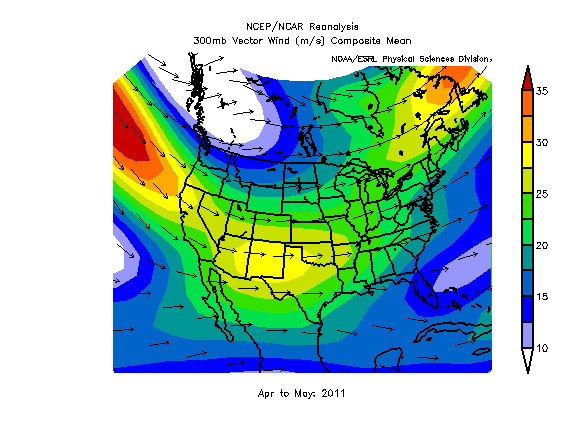
See how far north and weak the jet stream was. Tornadoes were above normal in southern Canada, below in the CONUS.

In 2011, coming off the strongest La Nina since the 1950s or early 1970s, the jet stream was ideal for severe weather with a southern jet and northern jet. Tornadoes were favored to the left front of the southern jet and right rear portion of the northern one. That is where upper divergence is favored.


See how the negative PDO which favors La Ninas by 2 or 3 to 1 and favors stronger (EF3-5) tornadoes (and more big outbreaks) correlated well with the EF3-5 counts.

How?
Through what factors or mechanism?
It ‘counted’ in the Ft. Worth CWA (forecast and warning area) IF there was damage (or video). The public is notorious for citing something as benign as roll clouds and mammatus as ‘nados … there is also straight-line (outflow and downburst winds) wind damage, which is not the product of ‘nadoes either …
What kind of topology? Very curious about that factor … don’t recall seeing any papers on that subject (unless you’re alluding to ‘geography’ instead e.g. central and midwest CONUS areas) …
.
Here’s the set up for bad storms on the Southern Plains. Anytime it is late in the season (April 1 onward) and a “Siberian Express” or “Yukon Express” is sending cold core systems straight south along the Pacific Coast and those systems are taking a hard left turn down by Baja, that is the set up. Full stop. I’d say there is a degree of correlation between this set up and La Nina and to an extent with Negative PDO. But as we can see that cannot be the sole factor. Although 1974 was definitely Negative PDO and heading toward the bad La Nina of 1975 – 1977
“What kind of topology? Very curious about that factor …”
I used “topography” to refer to both broad geographic as well as local effects. Broadly speaking the alignment of the Rockies and Appalachians provides an unobstructed corridor for cold air to move south and warm Gulf air to move north. That’s primarily why 73% of all tornados happen in the USA, and more specifically in tornado alley. The colliding air mass provide the trigger to lift the air. The Rocky Mountains from a barrier that dries and cools the air as it flows from the west . This provides the upper level dry air that promotes free convection. Still in order to progress from a super cell thunderstorm into a tornado, rotation is needed. That rotation is likely due to “jet streaks” embedded in the the more general jet stream flow. Jet streaks are commonly caused by contrasting surface temperatures created by differential cooling and heat of those surfaces. Dry uplands and wet lowlands can initiate jet streaks. As an aside, I am curious if tornado’s “fondness” for trailer parks is a function of local heating that facilitates jet streaks.
Well, that’s what I thought … don’t know about trailer parks, but, trailers themselves are boxes basically set on ‘skimpy’ pads with little to no anchoring and are subject to straightline wind damage (that kind of blamed was often blamed on ‘nadoes).
You process of tornado genesis could use a little refinement too, such as including the ‘local’ conditions created by the tornadoes themselves (e.g. rear flank downdraft winds) which hasten/aid/assist their going ‘viral’ in a big way:
http://en.wikipedia.org/wiki/Rear_flank_downdraft
“The rear flank downdraft or RFD is a region of dry air wrapping around the back of a mesocyclone in a supercell thunderstorm. These areas of descending air are thought to be essential in the production of many supercellular tornadoes.”
It isn’t solely a matter of a cold front, warm air, and the jet stream; all those are necessary … but ignore some of the smaller, less outstanding factors (such as veering winds vs ‘backing’ winds) and all you’d ever have are gustnadoes and (more or less benign) waterspouts!
Gustnado – http://en.wikipedia.org/wiki/Gustnado
VEERING AND BACKING WIND
http://www.theweatherprediction.com/habyhints/48/
.
“You process of tornado genesis could use a little refinement too, such as including the ‘local’ conditions created by the tornadoes themselves”
Of course, but I wasn’t trying to write a text book on tornado formation, just outlining the broad regional factors that increase the probability of tornado formation. But you make my point. Its local climate not global climate that drives extreme weather.
_Jim says:
May 30, 2013 at 12:36 pm
Richard Holle says May 30, 2013 at 1:26 am
You don’t suppose that the lunar declinational angle dropping below 20.5 degrees at culmination has had some effect on the position of the jet streams, …
How? Through what factors or mechanism?
Reply; The lunar declinational angle relative to the equator at culmination varies from a Maximum of ~28.8 degrees either side to a minimum of about 18.3 degrees, as the 5.25 degrees it runs North and South of the ecliptic plane, goes in and out of phase with the 23.5 degrees of the axial tilt of the earth, on an 18.6 year period cycle.
At the times when the lunar nodes ( the declination at spring and fall equinox is crossing the ecliptic plane and the equator at the same time) the culmination of the apparent solar declination and the lunar declination at culmination is the same ~23.5 degrees, and the tidal bulges of both combine to produce king tides in the oceans and atmosphere.
These repeating tidal effects in the atmosphere set up synchronized waves in the atmosphere commonly called El Nino maximums that occur around the synergism of the solar and lunar declinational culminations. As the declinational angle of the moon increase up toward the maximum it causes a gap in peak effect right at culmination then returns as it passes back through synergy, these dual pulses of shear generation in the primary and secondary tidal bulges created in the atmosphere, cause a split peak in tornado generation, with a surge of hail production in the middle when the two components of the forming tidal bulge, warm high dew point air masses from the South East quadrant and the cooler dry air masses from the North West sliding toward the South East then carolis effects wrap them together just past the peak occurrence of the synergistic culmination angles.
Now that the lunar declinational angle at culmination is less than 20.5 degrees there is just a single peak at each primary and secondary tidal bulge effect in the atmosphere when the apparent solar and lunar culmination angles are the closest to the same, so it shifts the standing waves found in the jet streams (that help to produce conditions for tornado production) temporally forward into the summer more than in the spring peak production that is seen, when the declination at culmination is above 24 degrees.
This effect can be clearly seen in the past distribution of tornado production from the past cycles shown in the initial links I posted;
http://research.aerology.com/wp-content/uploads/2010/03/6558days-cycle.jpg
this set of plottings uses the 6558 day long period of filtering past tornado data for repeating patterns, as it has higher synchronization than the 18.6 year Mn period or the 19 year Metonic cycle.
Part of the process of tornado production is based on the amount of available ions in the atmosphere and the charge gradient across the frontal boundary, more negative from the polar regions and more positive ions coming from the equatorial regions. It is this charge increase and decrease concurrent with lunar declinational tidal bulges that drive almost all intense or extreme weather.
Now that the solar magnetic activity and the earth residual magnetic fields are decreasing together there will be less drive to produce ion charge gradient as strong as they were with a more active sun. So there will be more loopiness to the jet streams wanderings as well as lower ionic potentials, so the frontal boundaries will be more position varied than in the past more active sun periods as well as lower levels of extreme weather outbreaks.
Just because the actual conditions that allow for tornado formation didn’t get started until the peak of the season was almost past doesn’t mean they won’t linger into the season we usually don’t associate with tornado season. Everything else having to do with seasonal conditions seems to be running late this year although it wouldn’t break my heart to see the tornado season wind down in June like it normally does.
Wait, what? Is this really coming from the guy who insists BEST and other fraudsters *proved* warming with no significant UHI!
Steven, for an English or philosophy major or whatever you are you sure go out of your way to torture logic and language.
Ripping that quasi-quote out of context is a dis-service to Feynman who was likely referring to the scientific discovery *process*. He would not say there are no knowns and everything is an unknown. If you asked him whether the Earth orbits the sun he would agree Copernicus has been proved correct.
P.S. You want an absolute truth? Here’s one. Most people would revoke *your* skeptic card before that of anyone else.
Steven Mosher says:
May 30, 2013 at 7:59 am
Looks like Joe has tamed his Icecap story (which is where this came from) and has added a couple images from the Moore tornado, see http://icecap.us/index.php/go/joes-blog – it now says: