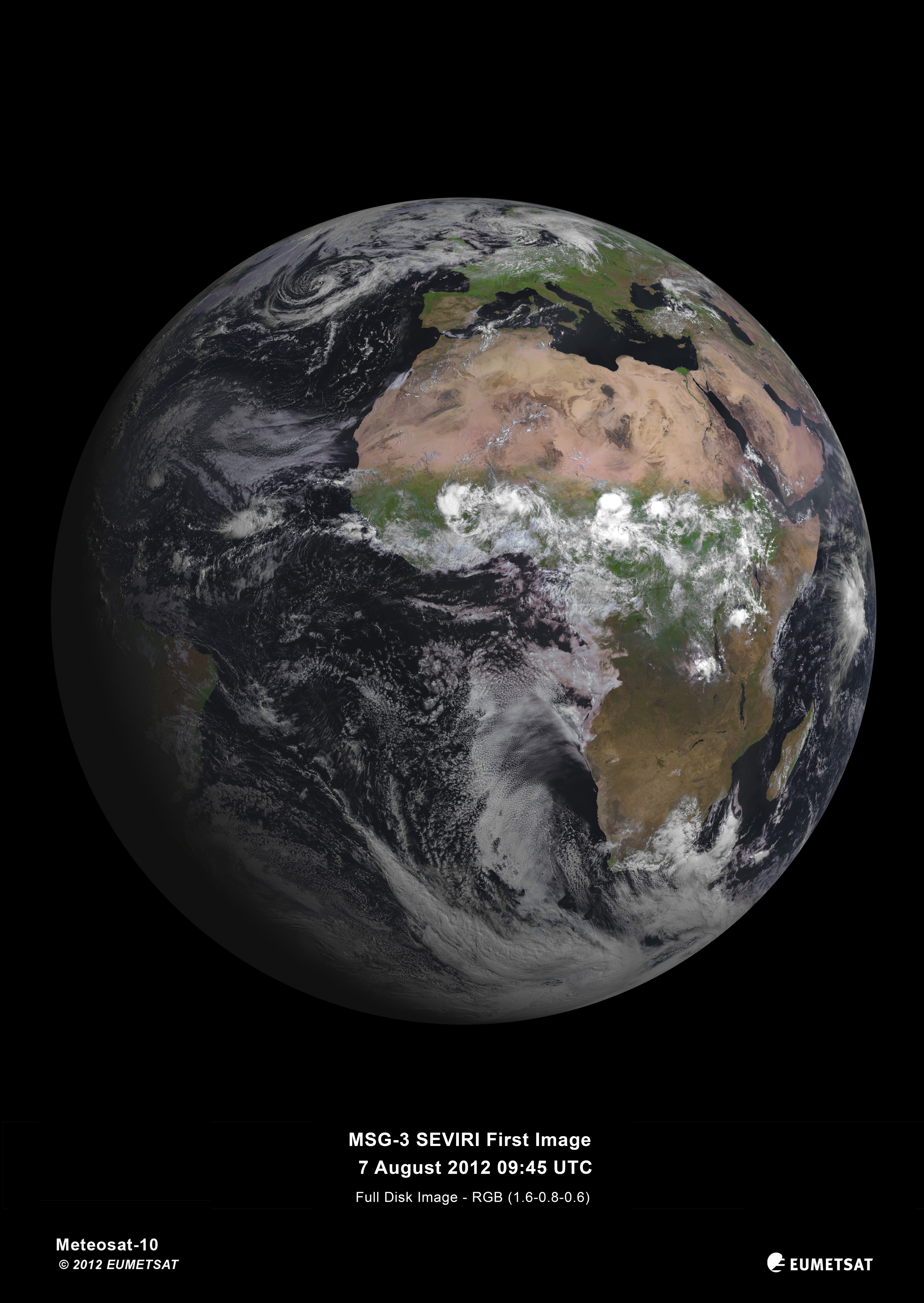
PR 25 2012 – Today, the Spinning Enhanced Visible and Infrared Imager (SEVIRI) instrument on MSG-3 captured its first image of the Earth (August 7th). This demonstrates that Europe’s latest geostationary weather satellite, launched on 5 July, is performing well and is on its way to taking over operational service after six months of commissioning.
The European Space Agency (ESA) was responsible for the initial operations after launch (the so-called launch and early orbit phase) of MSG-3 and handed over the satellite to EUMETSAT on 16 July.
The first image is a joint achievement by ESA, EUMETSAT, and the European space industry. For its mandatory programmes, EUMETSAT relies on ESA for the development of new satellites and the procurement of recurrent satellites like MSG-3. This cooperation model has made Europe a world leader in satellite meteorology by making best use of the respective expertise of the two agencies.
About Meteosat Second Generation
MSG is a joint programme undertaken by ESA and EUMETSAT. ESA is responsible for the development of satellites fulfilling user and system requirements defined by EUMETSAT and of the procurement of recurrent satellites on its behalf. ESA also performs the Launch and Early Orbit Phase operations required to place the spacecraft in geostationary orbit, before handing it over to EUMETSAT for exploitation.
EUMETSAT develops all ground systems required to deliver products and services to users and to respond to their evolving needs, procures launch services and operates the full system for the benefit of users.
MSG-3 is the third in a series of four satellites introduced in 2002. These spin-stabilised satellites carry the primary Spinning Enhanced Visible and Infrared Imager, or SEVIRI. The prime contractor for the MSG satellites is Thales Alenia Space, with the SEVIRI instrument built by Astrium.
SEVIRI delivers enhanced weather coverage over Europe and Africa in order to improve very short range forecasts, in particular for rapidly developing thunder storms or fog. It scans Earth’s surface and atmosphere every 15 minutes in 12 different wavelengths, to track cloud development.
SEVIRI can pick out features as small as a kilometre across in the visible bands, and three kilometres in the infrared.
In addition to its weather-watching mission and collection of climate records, MSG-3 has two secondary payloads.
The Geostationary Earth Radiation Budget sensor measures both the amount of solar energy that is reflected back into space and the infrared energy radiated by the Earth system, to better understand climate processes.
A Search & Rescue transponder will turn the satellite into a relay for distress signals from emergency beacons.
The MSG satellites were built in Cannes, France, by a European industrial team led by Thales Alenia Space, France. More than 50 subcontractors from 13 European countries are involved.
The last of the series, MSG-4, is planned for launch in 2015.
Bootifull.
I cannot see any detail in this image that is definitely attributable to humans, though it looks like there’s a large source of smoke in southern Libya – which could be natural. Not even any obvious contrails.
Anyone else seen something we’ve done?
A superb image. Unfortunately, being geostationary, this is the only angle it will ever see.
Fantastic photo.
Of course, the challenge for Americans, is “Name the continents”! 😉
Wow. It really picks out the greenery. The Okavanga delta in Botswana really stands out.
1 Km pixels is impressive resolution for a global scan, the future appears to be arriving faster these days.
Good to see they can get something right. The European space industry is full of what ifs and maybees, first of which is what if the UK hadn’t scrapped the budget for launchers just at the wrong moment. Maybe this satellite would have gone up on a British rocket and Dan Dare would be on Mars.
The Geostationary Earth Radiation Budget sensor sounds like a very handy bit of kit indeed. It should settle quite a few arguments. I wonder how it is calibrated, and whether its results will need to be “adjusted”
@steveta_uk: The Aswan Dam with Lake Nasser can bee seen. Definitively attributable to humans.
Here is a link to other EUMETSAT Images,
http://oiswww.eumetsat.org/IPPS/html/latestImages.html
steveta_uk
How about the lakes behind the Nile dams?
One of the first things it would have seen is a very rare snowfall in Johannesburg. No doubt this event was predicted by the global warmers….
http://www.bbc.co.uk/news/world-africa-19163119
I see the UK is lost under cloud and rain…….again
steveta_uk says:
August 8, 2012 at 12:12 am
————-
If you zoom onto the same area using Google Earth, it is also visible. It appears to be effect of some kind of a darker sand, possibly due to the surface tar.
Interesting to note the change in cloud cover along the equator between land and sea surfaces.
David Wright
“I wonder how it is calibrated”
It’s called ‘ground truthing’. You use the appropriate instruments to measure precisely the relevant variables at chosen points on the ground, and then calibrate/adjust the satellite’s remotely sensed data to match if there is sufficient deviation to warrant it.
WOW !!!
Adam Gallon says:
August 8, 2012 at 12:35 am
Fantastic photo.
Of course, the challenge for Liberal Americans, is “Name the continents”! 😉
Fixed.
now whack some desal plants up that top end..and see it go green 🙂
SEVIRI delivers enhanced weather coverage over Europe and Africa in order to improve very short range forecasts…
__________________
Now all they have to do is avoid any temptation to run collected data through the super computer over at the Met Office.
Looks like all the Arctic ice melted. 🙂
I forget the highest latitude visible from geosync orbit, but several degrees worth are viewed too obliquely to be useful.
Adam Gallon says:
August 8, 2012 at 12:35 am
> Of course, the challenge for Americans, is “Name the continents”! 😉
Hey! It’s not our fault that Europe is stuck to Asia!
Adam Gallon says:
August 8, 2012 at 12:35 am
> Of course, the challenge for Americans, is “Name the continents”! 😉
Oh sorry, the better response is “Africa sure looks a lot bigger than Europe.” Perhaps someone can remap the image to a Mercator projection.
When you say “MSG” we think Monosodium Glutamate, Earth as a full bowl of Chinese noodles. And why not?
Tasty photo.
steveta_uk says:
August 8, 2012 at 12:12 am
Bootifull.
I cannot see any detail in this image that is definitely attributable to humans, though it looks like there’s a large source of smoke in southern Libya – which could be natural. Not even any obvious contrails.
Anyone else seen something we’ve done?
I think the 1 km resolution might be to blame for that – although a contrail may be several kilometres in length, its width would be too small to be resolved. The same would go for structures, and I think the best we could hope for would be large conurbations appearing as different colours. It’s like we don’t exist, for all of the effect we’re having :).
Beautiful image, though!
Love the clouds over Africa. Where there are clouds it’s green. Where there are no clouds it is brown.