The news last week was the quick turnaround, this year it is the speed of ice growth.
JAXA extent shows sharp growth, exceeding the 2009 rate, and almost as fast as 2005:
 JAXA AMSR-E Sea Ice Extent -15% or greater – click to enlarge
In the last week, over a half million (505,938) square kilometers of Arctic Sea Ice has been added, one of the fastest gains in the satellite record.
On October 6th 2010 JAXA sea-ice extent has now broken through the 6M km2 line with 6,015,156 km2
10,04,2010,5892656

10,05,2010,6001406

10,06,2010,6035625

10,07,2010,6095781

10,08,2010,6205781

10,09,2010,6316563

10,10,2010,6398594
The DMI 30% extent chart could very well exceed the 2006 line in the next day or two, it has already exceeded the 2005 line.


And, compared the 2007 year, the refreeze is looking strong at CT:

Note though that Cryosphere today’s image has not updated since 10/07/10. Hopefully it will be back online tomorrow. There’s been some sensor issues seen at the NANSEN sea ice page the last few days, and since CT also uses the same data, that may be the issue.
UPDATE: Reader “AJB” offers this plot:

At Antarctica, after a weather induced dip, ice is rebounding and above normal, as well as ahead of this time last year. We have bipolar growth this week.
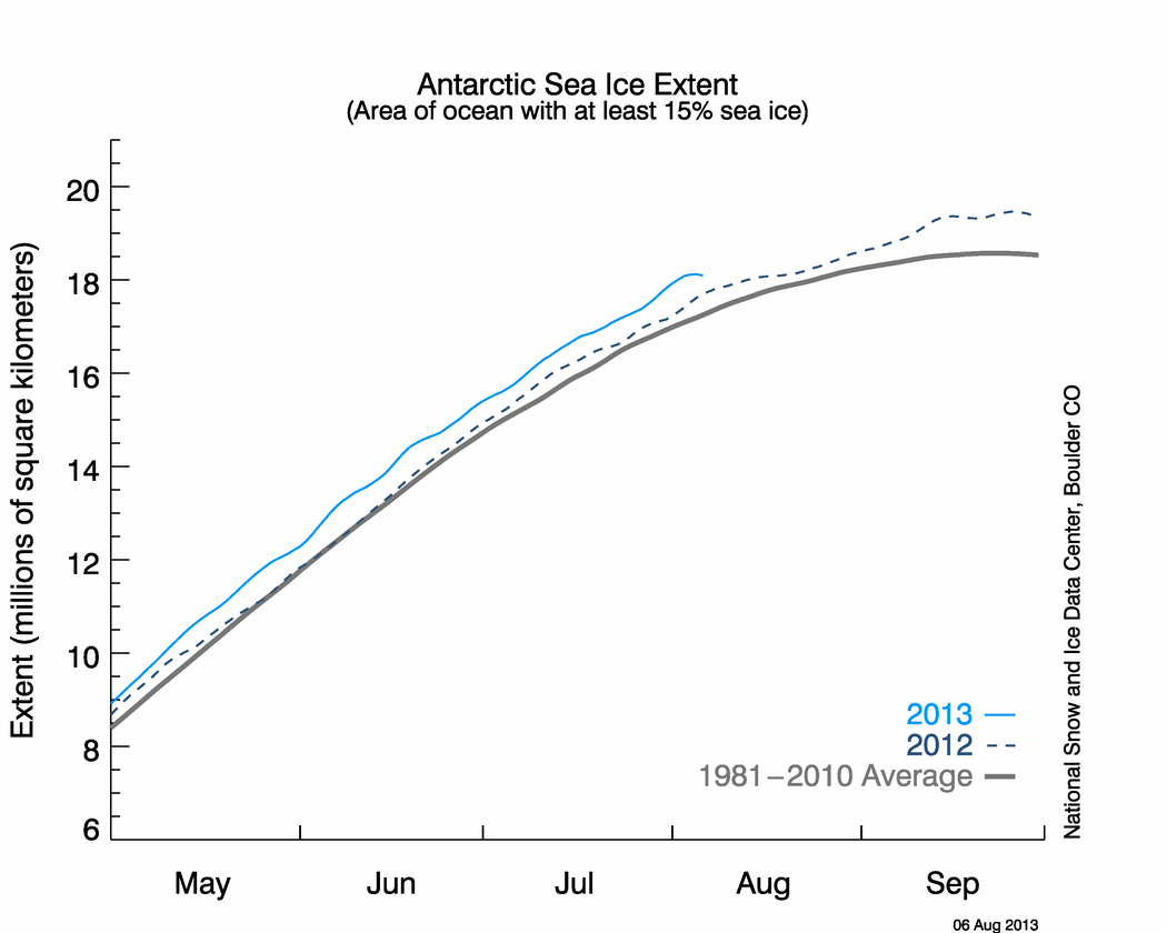 NSIDC Antarctic Sea Ice Extent – 15% or greater – click to enlarge
Ice just begining to form off Pt barrow,Ak beach
http://seaice.alaska.edu/gi/observatories/barrow_webcam
There was some Slick ice forming when I posted but that has gone…Beach water temps are at 29 degrees so it could happen anytime..
Phil. says:
October 11, 2010 at 10:33 pm
rbateman says:
October 11, 2010 at 1:43 pm
Phil. says:
October 11, 2010 at 12:50 pm
Why disuss it when you can see for yourself where they are in the radar image from October 12, 2010 which shows the location of the Petermann Ice Islands A, B, C, D, just above Coburg Island and several pieces that don’t have a letter.
http://www.ec.gc.ca/glaces-ice/default.asp?lang=En&n=D32C361E-1&wsdoc=B75BC3BC-8FD3-45D2-AA65-FDF066FB0231
Per Canadian Ice Service:
“October 18, 2010 – – On October 8, 2010, the PII-A and PII-B almost re-united off the southeastern tip of Ellesmere island. Shortly after, PII-B broke into 3 pieces with many smaller pieces nearby the “parent” icebergs. Two small pieces found their way 140 km further south and lay almost due east of Devon Island. ”
http://www.ec.gc.ca/glaces-ice/default.asp?lang=En&n=5C140C5D-1&wsdoc=082CD667-6A9B-4205-AE25-A12B00D4E32B