By Steve Goddard

Darkness is returning to the Arctic as the sun moves towards the horizon. In four weeks, the sun will disappear completely at the North Pole.

Solar Energy as a function of latitude and date
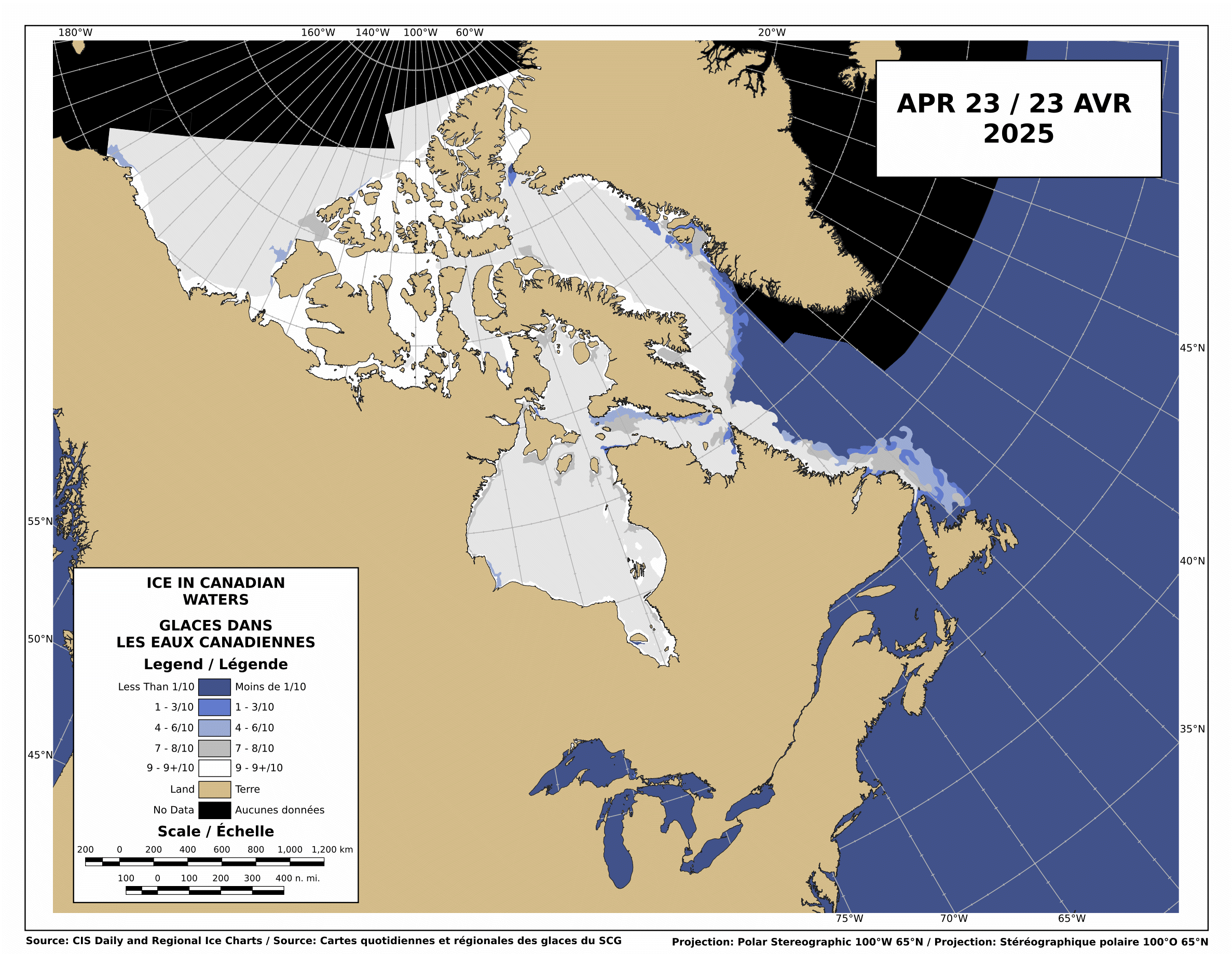
The Canadian Ice Service shows that there is still low-medium concentration ice blocking the Northwest Passage.

http://ice-glaces.ec.gc.ca/Ice_Can/CMMBCTCA.gif
If you owned a ship, would you send it through a route knowing it will face shifting pack ice, possible icebergs, fog, darkness, wind, storms and the possibility of an early freeze?
“The plans that you make can change completely,” he says. This uncertainty, delay, liability, increased insurance and other costs of using the Northwest Passage are likely to deter commercial shipping here. A ship with a reinforced hull could possibly make it intact through the passage. But if it got stuck, it would cost thousands of dollars for an icebreaker like the Amundsen to come to the rescue. So even if the Northwest Passage is less ice-choked than before, the route may not become a shipping short-cut in the near future, as some have predicted.
The Arctic Oscillation was negative for a few days, which allowed colder air to escape from the Arctic and warmer air to invade the Arctic. Note that the period of positive AO starting in early July corresponded to the Moscow heat wave. The cold air was trapped in the Arctic.

The negative dip this week allowed a blast of southerly air to melt and compact the ice during the past week, as we forecast in last week’s sea ice news.
")

http://ocean.dmi.dk/arctic/icecover.uk.php
Ice extent loss has dropped off dramatically in the last few days, as seen in the DMI graph above and the JAXA graph below.

Note that there was little loss in ice extent during 2006, after August 22.

What does the remainder of 2010 hold? Difficult to say. NCEP forecasts freezing temperatures over the broken ice in the Beaufort Sea during the next two weeks.

http://wxmaps.org/pix/temp2.html
If the remainder of the summer follows a path like 2006, 5.5 million is the right number. Another blast of southerly wind during the next few weeks. and it goes below 5.5. All of the ice indexes currently show 2010 ahead of 2008. DMI and NORSEX show it ahead of 2009 as well. JAXA also shows that the ice area curve has flattened. Ice area is always less than extent, and area trends tend to lead extent by a week or two.

There are large areas of low concentration ice which are vulnerable to compaction, spreading or melt.

My forecast remains unchanged. 5.5 million, finishing above 2009 and below 2006. Same as it has been since May.
The video below shows ice movement in the Beaufort Sea this week. Earlier in the week, it was compacting rapidly, now it is slightly expanding.
It all comes down to the temperature and wind over the next few weeks.
PIOMASS forecasts continue to stray further from the mark. Areas in red are places where PIOMASS incorrectly forecast melt. Solid green is the opposite misprediction.

Lindsay and Zhang forecast a minimum of 3.96 million in July.
The modified NSIDC image below shows ice loss during the last week. Mainly in the Beaufort Sea.

The modified NSIDC image below shows ice gain since 2007 in green, loss in red.

I’m not going to make a forecast for the next week, because there aren’t any dominant indicators either way.

R. Gates says:
August 22, 2010 at 10:56 am
Looks like the snow has just blown around and isn’t on the melt pond to my (untrained) eye. This seems to make sense to me, as I assume the refrozen melt pond surface is smoother/flatter than the surface of the older ice.
-Scott
R Gates says:
“We still got lots of warmer than normal water in the Arctic:”
“I think that the current warm SST’s in the Arctic will play out into a longer than normal end of the melt season”
I note the colour anomaly map but the talk of warm arctic SSTs is somewhat misleading, what is the present Arctic SST average temperature? The anomaly is about one degree but given the low SST then a single degree is hardly likely to melt sea ice as you claim and the DMI SST map is showing around -1 to +2 degrees C and I dont know about you but I think its over egging your pudding to state Arctic SSTs are “warm” I can assure you that zero to two degrees C is very very cold indeed and is not likely to melt gigantic areas of ice. Try dropping an ice cube into water cooled to one degree C and see how long the ice cube takes to melt, then try to do the same with water cooled to 2 degrees C and note how long the ice cube takes to melt. The water is 100% warmer but the ice will not melt measurably quicker will it? So you could say the water is much warmer but that would be disingenuous to say the least.
Can you clearly show actual temperatures and show exactly how much ‘warmer’ they are from ‘normal’?
The use of the word “warm” is misleading I think. BTW the DMI SST map shows no red whereas the NOAA map has lashings of the stuff, with red being only a very small rise in actual temps, a cynic might come the conclusion that NOAA is trying to scare us with the old paint it red for danger trick.
Jarmo says: August 22, 2010 at 11:13 am
“Funny, according to CPC AO running mean, the last two-three months have been positive and have reached value of +2:”
The chart you linked to is “The standardized 3-month running mean value of the AO index”;
http://www.cpc.noaa.gov/products/precip/CWlink/daily_ao_index/month_ao_index.shtml
whereas Steve highlighted the Daily AO Index, which supports his assertion:
http://www.cpc.noaa.gov/products/precip/CWlink/daily_ao_index/ao.sprd2.gif
Jarmo, a 3 month running mean is useless when comparing week to week.
Here is the observed AO the past few months.
http://www.cpc.noaa.gov/products/precip/CWlink/daily_ao_index/ao.sprd2.gif
stevengoddard says:
August 22, 2010 at 9:57 am
> Whatever happens with the ice, looks my Chelsea prediction is spot on. 6-0 again. MU would have lost today except for a Fulham own goal at 86 minutes.
Odd, at http://wattsupwiththat.com/2010/08/20/giss-shaping-up-to-claim-2010-as-1/#comment-462132 you note “Why are so many people intent on changing the subject?”
http://wermenh.com/runnings_2010.html 🙂
BTW, there’s no significant news I see about the boats poking around the Arctic, see http://www.explorersweb.com/oceans/
For context and perspective, could someone reprise the correlation-correspondence (if any) of La Ninas in conjunction with 30-year PDOs as affecting Arctic sea-ice area and extent? On a global basis, major cycles ought somehow to cancel or to reinforce, lending a quasi-predictive aspect to one component or another.
As a side note, I find it quite interesting to watch the Northern Passage 2010 expedition (to go through both the NW and the NE passages in the same season) these days…
http://www.ousland.no/category/northern-passage-2010/
Cassandra King says:
August 22, 2010 at 11:41 am
Regarding Arctic SST anomalies: “The use of the word “warm” is misleading I think.”
_____
When looking at longer term climate changes, anomalies are really all that matter. Otherwise you’re just talking about the weather, and when talking about anomalies, saying something is warmer than average or cooler than average is exactly the right choice of words. Also, 1 degree C makes a very big difference, especially in regards to Arctic water temps, as it water can be right at the “tipping point” for where ice floating in it will melt or not.
Now in regard to some human standard of warm or cold, I sure would not take a dip in the Beaufort sea right now, even though it is running well over 3 C above the longer term normal for this time of year.
Ric Werme says: August 22, 2010 at 11:55 am
“BTW, there’s no significant news I see about the boats poking around the Arctic”
The last significant update appears to be Aug 1st;
http://www.explorersweb.com/oceans/news.php?id=19550
which includes links to most of the expeditions poking around the Arctic:
RX 2 (Norwegian) with Trond Aasvoll, Northwest Passage West to East
http://trondaasvoll.seilmagasinet.no/
Issuma (Canadian) Northwest Passage East to West
http://www.sailblogs.com/member/rhudson/
Sarema (Finnish) Northwest Passage West to East
http://www.northwestpassage2010.blogspot.com/
Peter 1st (Russian) with Daniel Gavrilov and six other young Russians, Northeast and Northwest Passage
http://rusarc.ru/
Northern Passage (Norwegian) with Børge Ousland og Thorleif Thorleifsson Northeast and Northwest Passage
http://www.ousland.no/blog/
JOTUN ARCTIC (Norwegian) with Knut Espen Solberg, climate research East Greenland
http://fotspor.org/
Saxon Blue (UK) with Harvey Jones and Andrea Stokes sailing the West coast of Greenland.
http://blog.mailasail.com/saxonblue
Teleport (Australian) with Chris Bray and Jess Taunton are doing the Northwest Passage in two stages and are sailing their 29 foot junk-rig boat to Conception Bay this season.
http://www.yachtteleport.com/
ARIEL 4 (Sweden) – Northwest Passage East to West
Alaska (Norwegian) with Espen Paulsen, Northwest Passage East to West
FIESTA (Norwegian) with Wollert Hvide, East Greenland
R. Gates says:
August 22, 2010 at 11:31 am
Temperature Anomalies have little meaning in such icy conditions.
It’s a windy crapshoot in a given year.
Now, the big factor is the Arctic/Antarctic Sea Ice Paradox.
Will they continue on thier 3-year increase bent, hopscotching from hemisphere to hemisphere, blasting away at hapless and uniformed masses from the Polar Ice Machines as winter descends?
The available supply of moderating heat energy in the Pacific is spent, and the North Altantic is the last defense.
The anomalous warmth in the N. Atlantic is not exactly in the best place as the sun sets south, so open to radiating out into space.
We’ll have to deal with the cards that are now on the table.
R. Gates says:
August 22, 2010 at 12:26 pm
Then choose your winter coat anomaloulsy.
Will you take the same anomalous coat for an Alaskan Winter that you would for a Texas Winter, or would you take an absolute coat?
R. Gates says:
August 22, 2010 at 10:40 am
The majority of these anomalies seem to be +0-1 C, which potentially could be significant. But what really matters is how do these anomalies compare to this time of year in 2005-2009? I don’t care if they’re slightly above normal compared to a baseline from several decades ago if we’re comparing to the last 5-6 years and I don’t know what those anomalies were.
-Scott
Here is a chart showing all the years since 1979 (using the NasaTeam Algorithm prior to the years that Jaxa became available). It requires a few adjustments to match up the two series and is not perfectly compatible but at least it is something to review (which one assumes the NSIDC could provide if it weren’t for all the important global warming functions they have to promote/do).
http://a.imageshack.us/img843/1189/day233aug21sei.png
Ric,
My mother used to tell me “If you don’t have anything nice to say, then don’t say it.”
Vince Causey says:
August 22, 2010 at 9:40 am
In a few weeks we’ll know for sure who was right, Steve or R. Gates
One can already tell R. Gates is wrong. But you’re right, it will be conclusive at minimum.
SSTs in the Beaufort Sea are far below normal. It doesn’t make any sense to consider SSTs in regions where there is no ice.
http://weather.unisys.com/surface/sst_anom.html
NEWS: Nunavut August 10, 2010 – 10:59 am
Northwest Passage still hard to navigate
It would be nice if we had an article, about on site observations, that was less than 12 days old.
Ice concentrations:
http://arctic.atmos.uiuc.edu/cryosphere/NEWIMAGES/arctic.seaice.color.000.png
stephen richards says:
August 22, 2010 at 10:02 am
It won’t be Gates. He is blinded by his religion. Maybe somewhere between the two of them. On verra.
I am forever amused by the pot as he calls the kettle black. If it’s somewhere in between, stephen, then where is the influence of religion? You may as well flipped a coin.
The paradox (Irony?) of these forecasts is that long term climate is a bit easier to predict than short term events whether they be considered weather or climate. So while many have their heads stuck in the frigid Arctic waters, hoping that they will quickly freeze up [;-) it’s becoming obvious that all these Sea Ice Reports are magical attempts to thwart off the LONG TERM picture.
The Arctic Sea will be ice free during the summer; for a few days initially and progressing to weeks then months; between the years 2020-2030.
Of course, as that becomes so obvious that even the Media imbeciles catch on to it, you will go back to??? Ah, yes! “It’s been open before, it’s been open before!”
Sure we are all watching “The Race”..but has anybody noticed the thin-er ice from the NEastern point of Greenland on out aways?…Being an AGW denier & Pro Ice supporter this particular aspect of the Ice has bothered me more than the Extent.
http://igloo.atmos.uiuc.edu/cgi-bin/test/print.sh?fm=08&fd=20&fy=2009&sm=08&sd=20&sy=2010
The Northwest Passage is not open at just the McClure Straits but a 3 other locations
http://img682.imageshack.us/img682/5820/cmmbctca.gif
Northwest Passage
http://img13.imageshack.us/img13/7373/arcticr.gif
animation of Northwest Passage over last 10 days
http://www.ec.gc.ca/glaces-ice/default.asp?lang=En&n=CE69E4DD-1
PS..A little Birdie (Penguin) just told me that Mondays Extent will show little Ice loss.
Some interesting info about the NW passage from Vilhjalmur Stefansson’s 1947 book “Great Adventures and Explorations” page 537 and onwards–
He describes how during the 2nd and 3rd decades of the 20th century the Hudson Bay Company had greatly expanded its trading posts in the Arctic which required the RCMP to also establish outposts both along the mainland and as far afield as Victoria and King William islands. He says this “necessitated the development of shipping along the Northwest Passage.” To service their outposts they sent one ship from the Atlantic side and one from the Pacific side which met at the Bellot Straits at Fort Ross, then each returning by the way it had come.
So to me it sounds like the NWP was actually navigated many times and regularly so prior to actually being navigated all the way through in one trip by the St. Roch. I would love to hear more about the HBC resupply trips from anyone who has studied this. TonyB?
Thanks again Steve. I follow your reports with interest.
But I hope they are better balanced than your sports ones. You failed to mention that United would have been out of sight, if Nani hadn’t had his late penalty saved!
R. Gates said at 12:26 pm
When looking at longer term climate changes, anomalies are really all that matter. Otherwise you’re just talking about the weather,……
So… positive climate anomalies melt ice? So if I’m standing on an Arctic ice berg and the SST (although that particular WEATHER component is not all that relevant to melting ice bergs) where I am is -.5C and the SST 1,500km over “there” in the Arctic is say +2.5C and when we add in all the points and do our averaging it makes for an anomaly, in our mythical moment in time and space, +1C, and because of our calculation the ice where I’m standing is melting? Reminds me of the old Thermos jug joke. How does it know?Maybe you could explain that, WITHOUT using any weather terms, of course because we know it’s the CLIMATE that drives weather – – in the models.
Oh, and – as it(s) water can be right at the “tipping point” for where ice floating in it will melt or not. Wow! There’s a real interesting “scientific” statement if I ever heard one. Obviously true, there is a theoretical “tipping point” for ALL negative/positive processes. BUT what is that point? Is it JUST SST temp.? How about: Air temp.? Water flow? Wind speed? -direction? Humidity? Barometric pressure? Sun angle? Surface condition? -contamination level?
Anyone care to add any more WEATHER conditions would change that point? That’s all I could think off the top….
Phil says
‘Rare’ is an interesting word to use when most of the yachts that attempted it over the last few years have made it.
They might find it a little harder to travel the passage if it was 1906 and they were doing it without any modern navigation technology. I don’t think the area was even mapped back then.