By Steve Goddard

JAXA shows the area immediately west of Barrow, Alaska as ice free. And it appears to be melting away from the shore.
The animation below shows the month of May so far.
This apparent melt surprised me, because the University of Alaska reports sea ice at Barrow 4-1/2 feet thick and topped by another foot of snow. The ice has thickened six inches during the past month and about 18 inches since the start of the year.


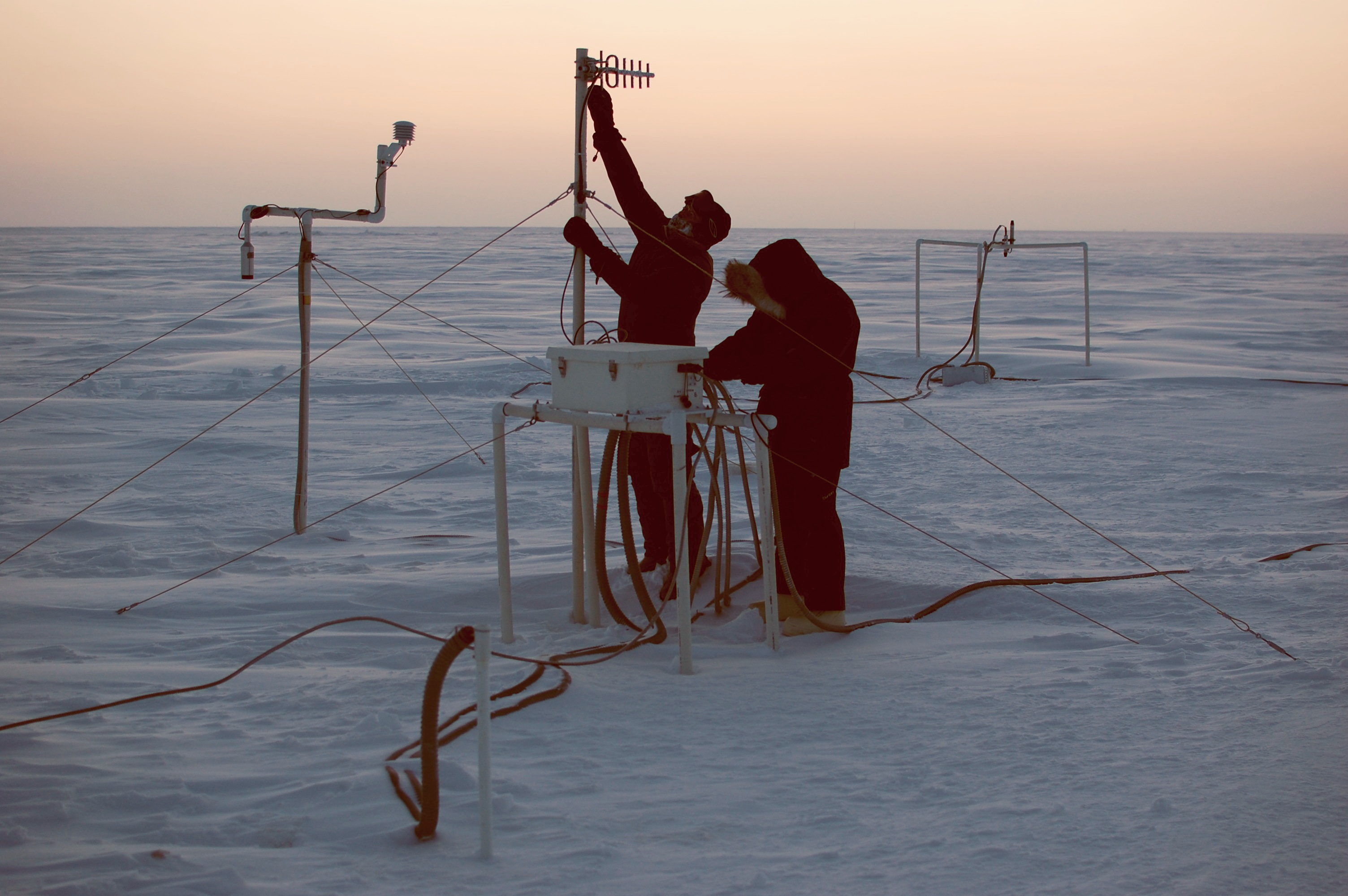
The sensor is located immediately offshore of Barrow, as seen below.

Below is the current view of the ice from Barrow.

We have an apparent paradox. The ice has been steadily thickening all year, yet a big hole has appeared in the ice near Barrow. The hole can be easily seen in the enhanced NASA satellite image below.

What could be causing the hole? The edges of the ice are clean and it has been too cold all month to melt, so something else must be going on.
The video below of the entire Arctic makes it clear. There has been a clockwise circulation which is shearing the ice away from the land in at least four locations (outlined by blue squares.)
We have found the recent decline in the JAXA extent graph, and it isn’t primarily due to melt.

AndyW
What part of the ice is getting thicker is it that you don’t understand?
http://seaice.alaska.edu/gi/observatories/barrow_sealevel/brw2010/BRW_MBS10_overview_complete.png
Anu,
If the Arctic ice “drops through the floor” I will definitely have super-special story just for you.
So it’s not GLobal Warming that’s causing the ice loss, it’s….
GLOBAL SPINNING.
We’d better tax that straight away.
Anu says:
May 27, 2010 at 11:04 am
‘The warmth was most pronounced in the equatorial portions of the major oceans, especially the Atlantic.
Warmest oceans on record, with an especially warm Atlantic.
Record fast melting of the thinning ice in the Arctic this April and May.
So, it’s not CO2 causing the Arctic ice to melt at record rates. It’s the warmer water making its way to the pre-conditioned Arctic ice, from the warmest oceans on record.
Which was caused by CO2 buildup.”
Not necessarily. I hate to keep bringing up Evans and Puckrin 2006 mostly because I think, at least in terms of the analysis offered, that it is pretty worthless. However the experimental technique they utilized of using spectral analysis to quantify the contributions of the various atmospheric components seems reasonably well designed and their data reasonable. From my point of view though they very much buried the lede, which is that in the presence of over 200W/m2 contribution from H2O the contribution from CO2 is greatly suppressed, going from 35W/m2 of 150W/m2 total in their winter data to 10.5W/m2 of 270 W/m2 total in summer.
How this relates to your statement is that the heat in the North Atlantic waters is transported there from tropical and subtropical latitudes by the Gulfstream. Most estimates and measurements of DLR in those latitudes are in the range of 375-450+W/m2, which if the suppressive phenomenon measured by E&P holds, would indicate that CO2 is responsible for less than 2% of the greenhouse effect at those latitudes and wouldn’t be culpable for any significant amount of all that heat moving into the Barents and Greenland seas.
When I first came across the E&P paper the first thing that struck me was that at last we have a technique which can settle the question of CO2’s role in the climate system and since they did the actual work in ’99-’00, I thought I’d find multiple examples of similar work done to expand the record. Despite a number of searches the only other example I’ve ever come across was done at the South Pole where predictably the frigid desert conditions showed CO2 accounting for a solid third of the total DLR. Total DLR is measured at dozens of sites across the planet, but near as I can tell none of them have added this kind of spectral analysis to show which components of the atmosphere are generating the radiation. If I was a more cynical type I’d have to think that they really don’t want know.
oops, should be “they really don’t want to know”
R. Gates says:
May 27, 2010 at 7:27 pm
“You can’t get differential heating without just plain heating…you need the solar energy.”
Heating is heating. I think you mean you can’t get heating without solar energy? But, you seem to have missed Daniel M @ur momisugly May 27, 2010 at 4:07 pm, who makes the valid point that AGW is supposed to decrease differential temperatures, not increase them.
Someone above might have corrected already, but the term is “SHEAR” not “sheer”.
Sheer, among other things, is a measurement of the fineness of stockings, which is a much more interesting topic to measure, especially as you approach the maximum height, where there can be a doubling of sheer – and a place for the tipping point. Ah! the warmth. The gyre. The response to perturbation. The mass perturbation. The memory of days gone by …….
When I look at unisys for the temperature at sea level in one of the shear areas, I see a temperature below freezing.
Specifically off Pt. Barrow the temp is -2C. No wonder the ice is growing off Pt. Barrow…the salt water is below freezing.
http://weather.unisys.com/surface/sst.html
So much for the theory of open water on May 27th in the Arctic Ocean being hot enough to melt ice.
Test: Failed.
Anomaly: Misleading.
R. Gates says:
May 27, 2010 at 7:08 am
Here you go again Steve…
First, you said:
*
*
So then, you’re an AGW propagandist?
You must be, seeing as how you’re continually pushing your propaganda message.
As Goebbels once remarked: “If you repeat a lie often enough, it becomes the truth.”
Ice in the Arctic sheers and shears in the Spring and the boy ice (you know) and then the calfs come. It’s a birds and bees and ice thing, y’know. Ice won’t get much thicker unless this happens. The same thing happens to glaciers, how else does it get miles thick? Thin ’bout da sea’r bu’tee ob id all.
PS: I thought spelling went out in the ’60s with draft cards;-)
Stevge Goddard,
When are you going to stop ignoring points that seem to counter what you say and instead bring up something I haven’t even commented on? I see this as a common trait in your replies, and they are also getting increasingly combative too for some reason. Some of your points are interesting and right, some are interesting and wrong, at least to my current knowledge, so I am giving you the chance to put counter arguements, but instead you side step always.
Andy
@Anu
‘If I believed the 53 mile wide Bering Strait (with an average depth of 30 to 50 meters) was as important to Arctic warm water transport as the 770 mile wide (ocean part, not including Iceland), deep (800m and 600m channels), Greenland Scotland Ridge, then yes, I might believe in a “significant recovery” this summer.’
So, essentially, just because you can’t understand that a “narrow” strait can lose more ice than a whole “wide” ocean you don’t, dare I say want, to believe it.
That’s about sums it up.
So from which side does the ice come from when it’s pressed out the other side from, well, the other side? Here’s some troll reasoning for ya’, which side exert the most cumulative pressure you think the narrow side or the “broad” side? :p
R. Gates:
Two things wrong with your argument:
1) As energy cannot be created or destroyed, if more net energy is entering earth’s systems than leaving then the total energy in the earth’s systems would continue building, even if everything else remained static. And, as that process would have begun when greenhouse gases first appeared, the earth would have been baked to a crisp a few billion years ago already – in which case, this discussion would certainly not be happening.
2) If some proportion of the energy in the system is manifesting itself as wind, ocean currents etc (of which I have no doubt, BTW), then simply measuring temperature anomalies (or trying to) without measuring anomalies in wind and ocean currents etc, or even quantifying energy proportions, tells us little or nothing about the energy flow in the system, or how much it’s changed – or not.
AndyW
You are quoting ice figures for regions of the Arctic which are always ice free in late summer. They have no relevance to the minimum, thus I am not spending any effort discussing them.
Steve Goddard said
“You are quoting ice figures for regions of the Arctic which are always ice free in late summer. They have no relevance to the minimum, thus I am not spending any effort discussing them.”
You are correct and I agree, but it was you who said the whole of the reduction up to now was due to not melt, a broad generalisation that I think is totally wrong. Similarly, I can turn the argument back on yourself and say lets not discuss these Arctic Basin “shear” polynyas now because come September they won’t mean a damn.
I think we should toss everything up in the air and get a better understanding.
The acid test to your theory is whether this ice free zone gets smaller or stays the same size or gets larger. If it gets larger then I’d fall on the side of melt encouraging the wind and currents here to expand the area.
Andy
stevengoddard says:
May 28, 2010 at 8:16 am
AndyW
You are quoting ice figures for regions of the Arctic which are always ice free in late summer. They have no relevance to the minimum, thus I am not spending any effort discussing them.
You’re not discussing anything relevant to the minimum anyway, your model results don’t agree with the actual observation in 2007/8 but still you trot them out. Pre-emptive strike for when your predictions for the fall are wrong perhaps?
This is how it started in the film” the day after tommorow”.
Latest Bremen map
http://www.iup.physik.uni-bremen.de:8084/amsr/arctic_AMSRE_visual.png
Ice free zones in the Artic basin are still getting bigger.
Andy
ratata says:
May 28, 2010 at 7:54 am
@Anu
‘If I believed the 53 mile wide Bering Strait (with an average depth of 30 to 50 meters) was as important to Arctic warm water transport as the 770 mile wide (ocean part, not including Iceland), deep (800m and 600m channels), Greenland Scotland Ridge, then yes, I might believe in a “significant recovery” this summer.’
So, essentially, just because you can’t understand that a “narrow” strait can lose more ice than a whole “wide” ocean you don’t, dare I say want, to believe it.
That’s about sums it up.
So from which side does the ice come from when it’s pressed out the other side from, well, the other side? Here’s some troll reasoning for ya’, which side exert the most cumulative pressure you think the narrow side or the “broad” side? :p
—…—…
Ratata:
Please note that an isolated system (a single inlet or outlet) would have almost no flow at all: the only transport path (for warm water to replace the water cooled by melting the ice) would be blocked by the water trying to exit. Today’s double entrance provides an inlet and outlet for continuous current flow of warm water to replace that which is cooled by the ice above.
So, if only a single entrance were present, Anu would need a strong in-rushing (warm) water flow going right over top of a colder, deeper outbound flow. Possible, but the net flow is much less – particularly when even part of that “hot ” outbound current itself passes under surface ice (as it must!) and cools down (as it must) and then falls down in front of the in-rushing cold currents trying to go the other way.
But, get a single strait wide enough and deep enough and Anu would get some flow through his (her?) single passage.
But his concern (about a single entry Arctic Ocean) is only applicable to another planet. It does NOT occur here – we have two straits providing access to the Arctic circulation patterns, so we can ignore his concern completely. Of course, if we close the Bering Straits off to much of the flow with a “dam” or causeway, then we would assure of ice freezing the Arctic completely. (Or we could wait another 30 years and let Mother Nature do it herself……)
Good find JK!
From his link above about the Bering Strait currents:
“WHY IS THE BERING STRAIT THROUGHFLOW IMPORTANT?
For the Chukchi Sea
– primary source of nutrients for the Chukchi (one of the most biologically productive regions of the world oceans)
– dominates the water properties of the Chukchi
For the Arctic
– primary source of nutrients for Arctic ecosystems
– melts back sea-ice in summer,
– provides cold waters in winter to stabilize the upper Arctic ocean (thus influencing ice thickness and upper ocean mixing)
– provides ~40% of the freshwater input to the Arctic
– water properties determine ventilation depth of the Arctic
For the World Ocean
– an important part of the global freshwater cycle
– believed to influence the Atlantic overturning circulation
Pacific waters can be traced through the Arctic and out through Fram Strait and the Canadian Archip”
Seems the current experts about arctic currents agree that much/most of the warm water melting arctic sea ice is from the Bering Straits.
The force be with you (Gates, are you switching from the dark side?). CO2 or warming isn’t causing ice sheer. In fact, ships are warned about this mirage. Do not think that these openings are signs of melt, lest you get caught in one that closes and traps your ship. This is what seductively opens up fake shipping lanes and then traps you, as Gates so kindly mentioned:
http://www.aari.nw.ru/clgmi/forecast/show_drift.asp?fign=0&lang=0