By Steve Goddard

JAXA shows the area immediately west of Barrow, Alaska as ice free. And it appears to be melting away from the shore.
The animation below shows the month of May so far.
This apparent melt surprised me, because the University of Alaska reports sea ice at Barrow 4-1/2 feet thick and topped by another foot of snow. The ice has thickened six inches during the past month and about 18 inches since the start of the year.


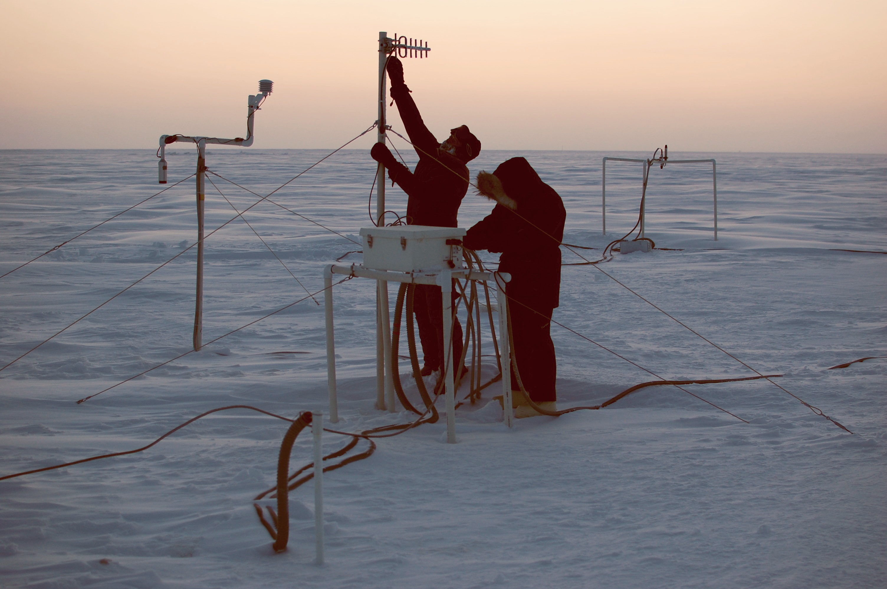
The sensor is located immediately offshore of Barrow, as seen below.

Below is the current view of the ice from Barrow.

We have an apparent paradox. The ice has been steadily thickening all year, yet a big hole has appeared in the ice near Barrow. The hole can be easily seen in the enhanced NASA satellite image below.

What could be causing the hole? The edges of the ice are clean and it has been too cold all month to melt, so something else must be going on.
The video below of the entire Arctic makes it clear. There has been a clockwise circulation which is shearing the ice away from the land in at least four locations (outlined by blue squares.)
We have found the recent decline in the JAXA extent graph, and it isn’t primarily due to melt.

***********
R. Gates says:
If I’m right, and the summer sea ice minimum is this year turns out less than 2008 or 2009, and not more, as Steve has said he believes will happen, then what? I suspect that your AGW skeptical nature will find other reasons why I just happened to be right, such as “sheer” forces or wind or who knows what else. I was ridiculed yestereday for example for pointing out that waves change the albedo of ocean water, especially for low sun angles, until I had to dig up all the research to prove my point.
I may well not know what I am doing, but I think I know a bit more about the Arctic then given credit…:)
*****************
Joe Bastardi is calling for a rather large melt also. It has nothing to do with global warming though:
“I realize I may raise the ire of people on my side of the AGW debate, but look I have a big ice melt season forecast and it is plummeting already. So yes, I am “rooting” on the ice melt here to demonstrate forecast accuracy, so when these people attack me for my colder viewpoints, you know who is objective and who isn’t. But this forecast was made over a couple of months ago, even before the recovery all the way to normal! Over the last month, Sea ice on all the data has moved from close to normal (in some sites above) to below normal for the Northern Hemisphere. My prediction is that while we don’t get to 2007, we will go past ’09 and ’08, but recover nicely this winter and beyond. But I am reading accounts that seem to be asleep at the switch at the dramatic downturn in Northern Hemisphere sea ice in the last month. It is real, it was expected as the forecast from this person continues to be a step back for the summer compared to the last two. All I care about is the right forecast and this looks to be one that will be spot on, no matter who gets mad about it. But remember what is following a rapid ramp up to a higher peak after the La Nina! Last year, and the year before I correctly predicted less ice melt, this year, I am solidly in the camp of more than the past two years. While my overall AGW position puts me on thin ice with those that are convinced that the Earth is warming because of man, I am sure this will also put me on thin ice the other way, but facts are facts. Look for yourself: ‘
http://www.accuweather.com/ukie/bastardi-europe-blog.asp
Should any body think that the total global sea-ice cover is declining must have a look at the south pole. The current sea-ice cover at the S-pole is breaking the record for this time of year. One must consider that the south polar sea-ice cover is about 20 % more then the north pole one. Hence an increase of say 1.0 % at the S Pole will balance out a decrease of 1.2% at the N Pole. The Global Sea ice cover is not decreasing. The total energy of the planet is the most important scientific parameter to measure in this debate. What is decreasing is the belief in AGW at global level. AGW is dead but politicians are pumping out millions of dollars/euros to keep AGW on life-support, so that they will be able to keep on taxing us and thus feed the AGW-business monster they had created and keep it ‘alive’.
http://www.iup.uni-bremen.de:8084/amsr/ice_ext_s.png
Put a couple of plots up on arctic ice extent, been meaning to do this for some time.
The situation continues to be ambiguous so all we can do is wait and see.
Wordpress short link
http://wp.me/PMOi6-2V
Hey, the ice is what it is.
Like waves on the oceans, they vary.
But the problem is we’re paying people to essentially count waves and speculate as to why they all don’t stay the same size and same frequency.
And as they ponder they recognize advantages to certain speculations.
Then the speculations morph into convenient conclusions which calls for more counting.
All we get is the privilege of paying for it.
But what do I know?
John F. Hultquist
It does “appear” from the JAXA maps to be melting, and that is exactly the belief being expressed in dozens of comments over the last few weeks – wrt the decline in the sea ice graphs.
I wonder if there is any data to indicate that there might be net polar rotational winds in right direction to account for this shearing or if this effect could be caused by under-ice ocean currents?
The sea ice situation is worse than it appears. All of that ice in the Bering Sea will rapidly melt in the coming days and at the time the true anomaly will become apparent and we’ll be way below any other year for this date.
REPLY: I think you are off in that prediction. We’ll see in about one to two weeks. Commenters take note. -A
I think the most likely explanation was the very negative Arctic Oscillation which would promote high pressure in the high Arctic, which would promote a clockwise flow of ice. Since the AO was so negative, there could be some momentum causing the ice to flow against the spin of the earth.
I think a positive AO is actually better for high Arctic ice formation and larger minimum extents due to low pressure creating cold weather and a counter-clockwise ice flow that while drawing in more salty, warm, Atlantic water, doesn’t flush vast amounts of ice down the east coast of Greenland (like we saw in 2007).
The last large summer minimum we had was in 1996 which came off of a very small winter maximum… thanks to a negative AO in the winter and a strongly positive AO during the summer. It was a perfect storm for lack of ice melt. I believe that extremely small amount of ice melt in summer ’96 aided the development of the super Niño in 1997/98… kind of like the vast melting in summer 2007 likely enhanced the upwelling in the equatorial Pacific, and thus strengthening the La Niña from the bottom up, rather than from changes in trade winds.
JJ
No doubt all that 4-1/2 foot thick ice will melt during the next week with 30 degree air temperatures.
James Sexton says:
May 27, 2010 at 8:33 am
@ur momisugly R. Gates,
I think what our friends are saying, it isn’t melt.
…
As you can see, the temps show what ever is occurring, one can’t call it melt. At least, not from the top.
…
Personally, I believe the underwater currents combined with volcanic activity underneath the Arctic is what we’re observing, but I’ve no way to prove it.
Yes, I think you’re right.
Melt from the bottom – the warm waters from the Atlantic (mainly) and Pacific (a bit) are causing the unprecedented melt rates this Spring:
Dropping. Like. A. Rock.
http://www.ijis.iarc.uaf.edu/en/home/seaice_extent.htm
In a few days, 2010 will have dropped past all the lowest sea ice extent years, and become the lowest for that date in recorded (satellite) history.
Notice how 2010 cut across all the other years ? (2006 coming soon)
How much heat gets into the Arctic from the warmer oceans ?
Too bad Argo can’t send floats under the Arctic ice yet – but they are working on next generation gliders to get this info.
8.5 °C water in, 2.0 °C water out. Sounds like a lot of ice-melting heat going up there from the warm southern oceans.
Because of the very narrow Bering Strait, most of the ocean heat enters the Arctic by way of the North Atlantic. It just so happens that this April, and this January to April, has had the warmest northern hemisphere ocean temperatures on record:
http://www.ncdc.noaa.gov/sotc/?report=global
The warmth was most pronounced in the equatorial portions of the major oceans, especially the Atlantic.
Warmest oceans on record, with an especially warm Atlantic.
Record fast melting of the thinning ice in the Arctic this April and May.
So, it’s not CO2 causing the Arctic ice to melt at record rates. It’s the warmer water making its way to the pre-conditioned Arctic ice, from the warmest oceans on record.
Which was caused by CO2 buildup.
Circling the drain?
(Down into the hollow earth.)
Isn’t “Death Spiral” a fighting technique used by Norsemen berzerkers?
>>>My linear projections show that if the rotation is this fast now,
>>>that by 2035, the ice cap will be rotating so fast that all the polar
>>>bears will spin off into the water and drown, and the baby seals will
>>>be crushed as the ice caroms off the coastline.
And it it rotates fast enough, we will get the biggest ice-circle in the world…
http://forgetomori.com/wp-content/uploads/2009/01/icecircledasf.jpg
http://208.106.181.133/_media/imgs/articles2/a96726_a474_icecircles.jpg
http://lh5.ggpht.com/_g4jfQ9COILQ/SkTeVoWqIkI/AAAAAAAAHxM/OE9ygQxdqMA/Ice%20Circle5%5B2%5D.jpg
I would like to see a calculation of how much of this ice melt was caused by Al Gore’s huge luxury $8.5 mansion, one of many which he owns. How much warming would occur if we all followed Al Gore’s example of how to live the green life?
Double standard much, Al?
Anu
If you believe undersea currents are melting the ice, then you should also believe that cold temperatures in the north Pacific hints at a significant recovery this summer.
@R. Gates
‘Seems that no matter what happens, AGW skeptics will try to find any OTHER reason for the ice to decline in the Arctic, other than the fact that the region has seen the bulk of global warming so far.’
Must be truly odd if you can’t see the hilarious in your attack, using a logical fallacy no less, of a scientist’s use of more proper logic debunking a crappy hypothesis.
ROFL. Do you see it now?
If I see one more occurrence of ‘sheer’ when people mean ‘shear’ I’m going to scream.
REPLY: Sheerly you jest? 😉 A
Non-update on the terrifying Arctic Sea Ice Volume Anomaly chart from the Polar Science Center using the PIOMAS model which the (C)AGW proponents have been posting for months as telling THE REAL STORY and clearly showing the Arctic Sea Ice Death Spiral:
No change. Last updated May 13, posted schedule for updates is every 3-5 days (based on data availability), now 14 days since last update when the graph was showing an alarming steep decline.
Maybe they read the criticisms of it here and decided the model needed further “validation.” Perhaps when done they can demonstrate it has all the robust accuracy of a tree ring, at least.
Look at Antarctic.Then Arctic. Arctic ice is floating in water. Antarctic ice is on land.
Antarctic ice is “exposed to air” only. Arctic to air and water. Whats the temperature of the air? Its above zero. Which one is thickest? What does it tell us regarding how much melting because of CO2? The answer is obvious; Its the ocean currents.
Ocean currents will be colder soon. No significant warming of air since….2001? So there will be a el Nino spike forwards; Some will gloat and say its CO2.
I think Gaia will come back and bite next winther. For 20-30 years.
But then again, I dont believe in Gaia.
R. Gates:
Yes, we do tend to look for reasons other than ice melt while the temperature remains at well below freezing point.
oh yawn are we still on the “oh yes it is, oh no it isn’t” pantomime chants about ice thickness and extent.
I’m not sure these endless updates about ice in the Arctic advance the cause for either side, as nobody knows the exact reasons or the implications. It is all speculation.
So lets wait until September shall we and then see wher we are?
Tamara says:
May 27, 2010 at 9:16 am
The Beaufort Gyre is not a fixed phenomenon (anymore than any other aspect of the climate). See this site: http://www.whoi.edu/beaufortgyre/results_fwcdecadal.html
It appears the Gyre was stable from the 50′s through the 80′s, then shifted in the 90′s. Could this be yet another 30 year oscillation?
At any rate, I think it is safe to assume that the shearing effect of the BG could vary from year to year, and is at least as likely to be contributing to the current conformation of sea ice as is CO2.
I have suspected for some time now that the primary driver of the decline in Arctic sea ice was the dramatic shift in the BG and the Transpolar Drift which occurred in 1989. What started me down that path was this animation from Rigor and Wallace
http://iabp.apl.washington.edu/animations/Rigor&Wallace2004_AgeOfIce1979to2007.mpg
Here is their description of the animation
The red dots shows the current location of buoys used to estimate the age of sea ice. The areas of older, thicker ice are shown in white, while younger, thinner sea ice is shown as darker shades of blue.
This animation of the age of sea ice shows:
1.) A large Beaufort Gyre which covers most of the Arctic Ocean during the 1980s, and a transpolar drift stream shifted towards the Eurasian Arctic. Older, thicker sea ice (white ice) covers about 80% of the Arctic Ocean up to 1988. The date is shown in the upper left corner.
2.) With the step to high-AO conditions in 1989, the Beaufort Gyre shrinks and is confined to the corner between Alaska and Canada. The Transpolar Drift Stream now sweeps across most of the Arctic Ocean, carrying most of the older, thicker sea ice out of the Arctic Ocean through Fram Strait (lower right). By 1990, only about 30% of the Arctic Ocean is covered by older thicker sea ice.
3.) During the high-AO years that follow (1991 and on), this younger thinner sea ice is shown to recirculated back to the Alaskan coast where extensive open water has been observed during summer.
The age of sea ice drifting towards the coast explains over 50% of the variance in summer sea ice extent (compared to less than 15% of the variance explained by the seasonal redistribution of sea ice, and advection of heat by summer winds).
For me what is most significant is the dramatic shift in where the residual ice ends up at minimum in Sept. Prior to ’89 most of the old ice is left west of the pole, after the change in the current circulation the old ice is left along the Canadian coast where the TPD, which changed from running mostly parallel to the Lomonosov Ridge to running almost exactly along the Prime Meridian, works almost year round to move it out through the Fram.
From reading the comments around here, it appears most people think that the winds are the primary drivers of ice movement in the Arctic, but having spent more than 60 yrs. living on the bank of the Mississippi in southern Minnesota, I tend toward currents being more important. If you’ve spent time in a houseboat, almost the perfect inverse of an iceberg, on the Mississippi you might also suspect that when it comes to a faceoff between the the wind and the current, the current comes out on top almost every time.
I’ve been watching the ice drift maps at DMI for a while and to my eye the patterns from this Spring suggest the BG may be returning to a pattern close to what it was in the ’80s, but they’ve shut them down for the season so we’ll have to wait to see how that pans out.
My Minnesota experience also tends to make me doubt the claims that melting is the leading cause of ice disappearing in the Arctic, at least within the confines of the Arctic Ocean itself. The west to east flow of the TPD across from the Bering Sea to the Fram looks to be somewhere between 1 and 1.5 degrees of latitude per month, which would suggest that open water from the Alaskan coast to Lat 77 to 80 or more west of the pole could be accounted for by movement alone.
So its NOT undersea volcanoes now
http://wattsupwiththat.com/2008/06/25/surprise-explosive-volcanic-eruption-under-the-arctic-ice-found/
Billy Liar says:
May 27, 2010 at 11:59 am
If I see one more occurrence of ‘sheer’ when people mean ‘shear’ I’m going to scream.
REPLY: Sheerly you jest? 😉 A
Yeah, it’s not shear that causes the polynyas anyway!
Extent graphs are disagreeing again.
2010 below 2006:
http://www.iup.uni-bremen.de:8084/amsr/ice_ext_n.png
Date on graph May 26 2010.
2010 still above 2006:
http://www.ijis.iarc.uaf.edu/en/home/seaice_extent.htm
Date on graph also May 26 2010.
Both use AMSR-E data. The possible difference? First is from IUP University of Bremen which carries a hefty disclaimer on their “High Resolution AMSR-E 89 GHz Sea Ice Images” page:
The second graph, of course, is from IARC-JAXA. And yes, both use 15% minimum sea ice concentration.
So, who do you want to trust?