By Steven Goddard

Break out the Speedos and Bikinis. Springtime has finally arrived in the Arctic!

Temperatures have risen about 15C, and are now averaging a balmy -15C (5F) north of latitude 80N – with sunshine 24 hours a day. Under those conditions, you can get frostbite and a tan at the same time.

http://ocean.dmi.dk/arctic/meant80n.uk.php
But despite the balmy weather, NORSEX ice area continues to run above the 1979-2006 mean – as it has for the entire month of April.

http://arctic-roos.org/observations/satellite-data/sea-ice/observation_images/ssmi1_ice_area.png
Since the melt season started, the Arctic has lost about one million km2 of sea ice. Below is a composite graph showing all of the popular (NSIDC, JAXA, NORSEX, DMI) extent measurements, superimposed on the NSIDC mean and two standard deviation region. The thin blue line is NSIDC extent from 2009. Note that all measurements have been nudging up against the mean line – for the entire month of April.

Disclaimer: All maps below are taken from NSIDC maps, and modified by the “breathtakingly ignorant” writers at WUWT.
During the last three weeks ice has melted mainly at lower latitudes, as seen below in red. Areas in green have actually increased in extent, due to drift. Ice is probably still getting thicker in much of the Arctic, because temperatures remain well below freezing.

The map below shows changes over the past week.

And the map below shows changes since the same date in 2007. Green indicates ice growth.

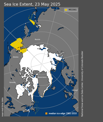
The next map shows current areas of deficient ice (relative to the median) in red, and excess ice in green. The total amount of excess minus deficient ice is close to zero. In other words – Arctic ice extent is normal.

The Arctic Oscillation remains negative, so circulation is clockwise – as seen below in the buoy drift map. This pattern is keeping older, thicker ice from the Canadian side inside the Arctic Basin, and bodes well for another summer of increased ice thickness and extent – relative to the record melt of 2007.

http://iabp.apl.washington.edu/maps_daily_track-map.html
People counting on bad news from the Arctic to keep their agenda alive are staring at a long, (rhetorically) cold summer……. The good news is that they can keep raising the red flags about Montana glaciers, if the Arctic refuses to melt.
It has now been over 41 years since the New York Times headlined “Expert Says Arctic Ocean Will Soon Be an Open Sea.” triggering the Arctic Death Spiral. After 41 years of dangerous and increasing melt, ice area is again above normal.
My failure to understand this is surely a sign of “breathtaking ignorance.” But don’t call me Shirley.
Ammonite says: on April 28, 2010 at 4:42 am, “Hi Kim. Rising CO2 absorption by sea water does indeed make it more acidic.” Only right in the most inconsequential way. Actually, the pH of seawater – about 8.24 currently, could fall to 8.16 with a CO2 concentration of 454 ppm – a trivial difference, especially if rounded off to 1 significant figure – 8.2 to 8.2 – and consider the huge difference to a neutral pH of 7. There is a chemical process called ‘Buffering’ involved, and a simplified discussion is here http://www.icsu-scope.org/downloadpubs/scope13/chapter09.html. End result, no acidification. Oh, also in the archives of this site is a discussion of how shelled creatures adapt rather well to so-called ‘acidic’ conditions.
“SteveE says:
April 28, 2010 at 6:00 am
What’s people’s opinion of the data that suggest while the Arctic sea ice extent is growing the actual volume is decreasing?”
That it is bloody unlikely.
SteveE,
It would be nice if someone published a regular map of ice thickness, but I have never seen that.
I got pinkflagged. I noticed that my snipped comment on the side bar showed up lilac pink instead of blue. I take it that means the commenter’s comment has been snipped while blue indicates a posted comment. Or am I pointing out the obvious and just didn’t notice it on the old format?
(hehehe)
Well, my educated guess about the color of my snipped post turned out to be wrong. Maybe I spend too much time looking at “little” details.
Dave N says:
April 27, 2010 at 10:02 pm
If you have data that shows otherwise, I’m sure others will be interested.
I have family there. They look out the window: no ice.
About the Danish ice:
It’s ice packing. The Danish newspapers have looked into this because the readers could not understand why the ice would not melt i the harbors and other places. But is packed so extremely hard that melting take for ever. On land Denmark have ice packed so hard that climate experts say they are more like little glaciers. Again: melting take unusually long time. The winter in Denmark was very hard this year.
We do have a couple of Danish newspapers in English but they don’t mention it. However a Dane did upload pictures on flickr:
http://www.flickr.com/photos/22385253@N06/4448421623/
SteveE says:
April 28, 2010 at 6:00 am
What’s people’s opinion of the data that suggest while the Arctic sea ice extent is growing the actual volume is decreasing?
http://psc.apl.washington.edu/ArcticSeaiceVolume/images/BPIOMASIceVolumeAnomalyCurrent.png
Considering the modeled derivation of that graphic mostly from spotty sub measurements and random surface measurements:
Sea Ice Volume is calculated using the Pan-Arctic Ice Ocean Modeling and Assimilation System (PIOMAS) developed at APL/PSC by Dr. J. Zhang and collaborators. Anomalies for each day are calculated relative to the average over the 1979 -2009 period for that day to remove the annual cycle. The model mean seasonal cycle of sea ice volume ranges from 28,600 km^3 in April to 14,400 km^3 in September. The blue line represents the trend calculated from January 1 1979 to the most recent date indicated on the figure. Total Arctic Ice Volume for March 2010 is 20,300 km^3, the lowest over the 1979-2009 period and 38% below the 1979 maximum. September Ice Volume was lowest in 2009 at 5,800 km^3 or 67% below its 1979 maximum.
with a cherry picked starting date (where’s the data from the forties) ….and knowing that satellite verification started only five or six years ago, my answer would be….not much.
Congratulations on the great sea ice report, very nice indeed. The truth has a way with making a brighter day for all.
We spotted no sea ice locally, but we have had a massive coconut palm tree die off because of all the cold weather in south Florida, due I am sure, to global warming …
Coconut palms fall victim to cold weather it really is sad to see all those majestic palms, now dead. We lost two in our back yard, 90 miles from Key West.
Stephen Skinner says:
April 28, 2010 at 5:34 am
In the New York Times artcile the 2nd to last paragraph makes an interesting claim.
http://wattsupwiththat.files.wordpress.com/2008/07/nyt_arctic_77442757.pdf
“There is eveidence that the carbon dioxide content of the world’s air has risen from 10 to 15 percent…”
This seems a bit of an exaggeration. What happened to the general understanding of the proportions of the constituent parts of the atmosphere? Unless this is some journalistic transmogrification that happens.
Probably the same thing happened to the general understanding of the proportions of the parts of the atmosphere that happened to the understanding of the abundance of elements in the Solar Nebula due to the proton-proton chain, CNO Cycle and SuperNova:
Vacuum-packed theory lacking a modern general science background.
Jack “In Oregon” Barnes: Actually, we’re having an “unusually early and warm Spring.” I heard that on KPOJ (local progressive station). I was relieved to find that out as the cold and wet were getting me down.
Incidentally, I have a foolproof model of the stock market. The beauty of it is that it predicts stock price based on a single factor. You practically don’t have to do any real research at all. Why wait to see how correct it is? Invest all of your assets now before it’s too late!
I suggest you take a look at the actual ice concentrations or better yet, look at some visible imagery like from MODIS and you’ll see your story will change somewhat…
Pamela Gray:
April 28, 2010 at 6:19 am
I’m glad you’re enjoying the day. It’s snowing here for the 3rd time this month, tying the 1928 record, and I cannot connect to a single dot edu site.
stevengoddard says:
April 28, 2010 at 5:18 am
Ammonite ,
Ammonites evolved during the Silurian, when atmospheric CO2 levels were an order of magnitude higher than at present. Unless the chemical properties of CaCO3 has changed, you can relax.
During the Silurian atmospheric CO2 levels were about 900ppm, however the higher temperatures led to ocean pH levels comparable to today’s and the ocean was less of a CO2 sink. The ammonite shells were aragonitic and therefore more sensitive to dissolution than those organisms that used calcite. In fact this is one of the reasons that has been proposed for their extinction when ocean pH decreased.
KimW says:
April 28, 2010 at 6:07 am
Ammonite says: on April 28, 2010 at 4:42 am, “Hi Kim. Rising CO2 absorption by sea water does indeed make it more acidic.” Only right in the most inconsequential way. Actually, the pH of seawater – about 8.24 currently, could fall to 8.16 with a CO2 concentration of 454 ppm – a trivial difference,….
A 30% increase in [H+] is not trivial!
It would be nice if someone published a regular map of ice thickness, but I have never seen that.
The reason being that it can not be measured from a satellite with any degree of reliability. It can be measured from aircraft, but only in a narrow swath below the aircraft, and from submarines, in an even narrower swath above, so we really only have a very vague idea about the current thickness and even less about thickness.
This is the root cause of the current popularity of ice volume as the proper measure of north polar Sea Ice. It can be computer modelled with almost no constricting restraint from real-world data.
When you do the coverage map comparisons, I think it would be useful to include the “maximum ice on record for date” map. Or, if that’s too involved, “ice coverage in 1983” which had the highest maximum coverage. (And thus probably has a fair share of highest-ever records.)
Caleb says:
April 28, 2010 at 2:16 am
Phil,
I liked the pictures contained in the link:
http://www.explorersweb.com/polar/news.php?id=19271
It shows the danger of camping on an ocean.
Leads can form even in the coldest weather. They occur because wind does not shift equally, over all places at the same time. When wind shifts to the east on one locale, while it still blows west at another, ice moves in opposite directions. It either parts, forming a lead, or it crunches together, forming a pressure ridge.
It would be very odd to have a pressure ridge form in the middle of your camp, in the middle of the night.
As I recall, one of the old pictures of a sub surfacing at the North Pole was taken in March, when ice is “at its thickest.”
Usually ice reforms in the open water between the two sides of the lead fairly quickly. If you look, you’ll notice the final picture in the link, at the very bottom, is of a interesting and rather lovely pattern the snow made, drifting over the fresh ice that formed on the lead.
That’s why Camp Barneo usually packs up at this time of year!
The region around the pole is full of leads as indicated by those photos and the reports of those expeditions heading there over the last few weeks.
MODIS images show the same particularly as the ice is drifting towards the Fram at a rate of ~10km/day. That drift causes the ice behind to crack open and form leads, at current temperatures it will ice over but only to a depth of a few inches not a foot or more, consequently the average ice thickness is reduced and the ice extent increases. What we have at present is thinning, spreading ice leading to many leads and a wind direction that has tending to move multiyear ice away from the coast to where it will tend to drift out of the Arctic. This year’s ice is very vulnerable to a 2007-like event.
Love the pic of the global warming models. I get it that they are Norwegians, but aren’t they freezing their buns off anyway?
Don’t let the frostbite you on the …
Universalgeni says:
April 28, 2010 at 6:40 am
It’s ice packing. Again: melting take unusually long time. The winter in Denmark was very hard this year.
That’s not the point. The maps showed the purported ice yesterday. There was no ice yesterday.
Phil, I completely agree. Although a stronger Beaufort Gyre tends to help replenish the ice cover, since the late 1990s the ice started melting out in the southernmost reaches of the Gyre, and moving further north in more recent years. Thus, even though the negative AO state in winter tends to help the summer ice recover, this hasn’t been the case in recent years. Furthermore, ice export out of Fram Strait was not anomalously low this year despite the strong negative AO. The amount of the oldest ice actually decreased during the winter. The idea that the ice has recovered is naiive. Ice extent is just one small piece of the picture…
Phil. says:
April 28, 2010 at 8:11 am
What we have at present is thinning, spreading ice leading to many leads and a wind direction that has tending to move multiyear ice away from the coast to where it will tend to drift out of the Arctic. This year’s ice is very vulnerable to a 2007-like event.
That’s an unusual observation. I’ve kept an archive of every Cyrosphere Today image of the Arctic I could this season.
The Ice isn’t flowing out, it’s more like a pulsating tide. Goes out, retreats back. Unless I missed something, looks to me like it’s not going anywhere in any significant amount.
Phil,
2007 was typified by unusual summer melt on the western side of the Arctic, and winter drift on the east. There is no evidence of either this year.
APRIL 28, 2010
http://weblogs.baltimoresun.com/features/green/2010/04/epa_turns_up_heat_on_climate_a.htmlEPA turns up climate heat as Senate dithers
Leif Svalgaard says:
April 28, 2010 at 8:28 am
Universalgeni says:
April 28, 2010 at 6:40 am
It’s ice packing. Again: melting take unusually long time. The winter in Denmark was very hard this year.
That’s not the point. The maps showed the purported ice yesterday. There was no ice yesterday.
It’s the shoreline effect from the satellite imaging, it’s worse with NSIDC because they still use the low resolution SSMI imager whereas CT uses ASMR-E which has higher resolution and shows no ice in the Danish waters.
http://arctic.atmos.uiuc.edu/cryosphere/NEWIMAGES/arctic.seaice.color.001.png
rbateman says:
April 28, 2010 at 8:34 am
That’s an unusual observation. I’ve kept an archive of every Cyrosphere Today image of the Arctic I could this season.
The Ice isn’t flowing out, it’s more like a pulsating tide. Goes out, retreats back. Unless I missed something, looks to me like it’s not going anywhere in any significant amount.
Ice has predominantly been flowing out of the Fram this year, see all that ice down the Eastern Greenland coast, that’s how it got there. Similarly the sudden increase in coverage in the Barents sea last month or so was outflow from the Arctic.
Check out MODIS when it’s back up.