by Steven Goddard and Anthony Watts
In late 2009, Anthony forecast that Arctic sea ice would continue to recover in 2010. Last month Steve Goddard did an analysis explaining why that was likely to happen and yesterday NSIDC confirmed the analysis.
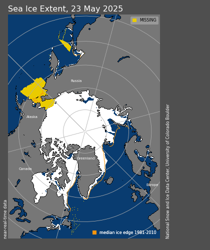
The pattern of winds associated with a strongly negative AO tends to reduce export of ice out of the Arctic through the Fram Strait. This helps keep more of the older, thicker ice within the Arctic. While little old ice remains, sequestering what is left may help keep the September extent from dropping as low as it did in the last few years.
The wording of NSIDC press releases usually highlight the negative (this one being no exception) but the message is clear. This summer is likely to continue the trend since 2007 of increasing summer minimums.
So how is Arctic sea ice looking at this point, near the winter maximum? NSIDC shows ice extent within 1 million km2 of normal and increasing.

http://nsidc.org/data/seaice_index/images/daily_images/N_timeseries.png
The Baltic and Bering Sea have slightly above normal ice. Eastern Canada and The Sea of Okhotsk have slightly below normal ice.

http://nsidc.org/data/seaice_index/images/daily_images/N_daily_extent.png
DMI shows sea ice extent at nearly the highest in their six year record.

Sea ice extent for the past 5 years (in million km2) for the northern hemisphere, as a function of date.
http://ocean.dmi.dk/arctic/icecover.uk.php
NORSEX shows ice area just outside one standard deviation (i.e. almost normal.)

http://arctic-roos.org/observations/satellite-data/sea-ice/observation_images/ssmi1_ice_area.png
There’s also some interesting comparisons to be made at Cryosphere Today. When you compare the current images in recent days with the same period in years past, you notice how “solid” the ice has become. For example compare March 3rd 2010 to March 3rd 2008, when we saw the first year of recovery:

Note that there’s no “fuzziness” in the signal return that creates this image on the right. A fuzzy return would indicate less than solid ice, such as we see on the left. The CT image from March 3rd is “deep purple” through and through. The edges of the ice are very sharp also, particularly near Greenland and also in the Bering sea. These two visual cues imply a solid, and perhaps thicker ice pack, rather than one that has been described by Dr. Barber as “rotten ice”.
I wish I could compare to March 3 2009, but the CT images were offline last spring then while both they and NSIDC dealt with issues of SSMI sensor dropout that was originally brought to their attention by WUWT, but was deemed “not worth blogging about“.
According to JAXA, 2003 was a good year for Arctic sea ice. Note the blue line.

So how does that year on March 3rd compare to our current year using CT’s imagery?

Compared to the best year for Arctic sea ice in the past decade, March 3rd this year looks quite solid. The setup for 2010 having more ice looks good.
You can do your own side by side comparisons here with CT’s interactive Arctic sea ice comparator.
The Arctic continues to recover, and one of the last CAGW talking points continues to look weaker and weaker. It wasn’t very long ago when experts were forecasting the demise of Arctic ice somewhere between 2008 and 2013. And it is not the first time that experts have done this – they were claiming the same nonsense in 1969, right before the ice age scare.

Note the column at the right. Even back then, skeptics got the short shrift on headlines because as we know: “all is well, don’t panic” doesn’t sell newspapers.
UPDATE: And then there’s this:
AROUND 50 ships, including large ferries reportedly carrying thousands, were stuck in the ice in the Baltic Sea today and many were not likely to be freed for hours, Swedish maritime authorities said.
In reply to PeterB in Indainapolis (12:31:44) :
Peter, I’ve never said whether I think a warmer world would be better or worse, as that hasn’t really seemed to be important…but since you asked:
Fire and Ice
FIRE AND ICE
by Robert Frost
Some say the world will end in fire,
Some say in ice.
From what I’ve tasted of desire
I hold with those who favor fire.
But if it had to perish twice,
I think I know enough of hate
To say that for destruction ice
Is also great
And would suffice.
Robert Frost
_________________
I’m simply looking at the true longer term trends (longer meaning in this case more than one or two winters, as some would like). For the past severa decades arctic sea ice has been trending down on a year to year average. This is the data. If continued, the arctic will be ice free in the summer before too many more decades have passed. Would this be good or bad for humanity? Who knows? Has this been caused by AGW? That is the trillions of dollars question.
Ref – Paul Daniel Ash (13:38:05) :
“… If something happened once due to natural variation then if it every happens again it has to be as a result of natural variation, for ever and ever, world without end amen? That’s weird logic.”
_________________________
Old Man Who Live in Cave Say:
Tis best to not ask specific people specific question unless they respect you.
Tis best to make statement to no one in particular.
Tis best to respond to best comment.
Tis best to not rock boat too much over teenie weenie matter.
Mike M,
You would probably appreciate this article:
http://wattsupwiththat.com/2009/01/10/polar-sea-ice-changes-are-having-a-net-cooling-effect-on-the-climate/
Steve — you spuriously use the base line of a record low and then claim a 33% increase. It does not change the fact that we remain at or near record lows in sea ice data and that February represented the fourth lowest in the record. Nor does it change the fact that lows are 2 standard deviations outside the norm.
Recovery, as your ‘news article’ claims, would be evidenced by a return to normal sea ice levels for many years, not a half-cloth misrepresentation of NSIDC data and back of the hand references about ‘fuzziness’ or lack thereof in Satellite images.
I made the dig about your money source as, evidenced by the articles you’ve written, you are clearly not interested in facts, only in their distortion and misrepresentation. At the very least, I would hope you receive oil company funding for the good work you do for them.
As for Anthony’s diatribe… My apologies for having missed that function on the cryosphere website. In the spirit of science, I will refine my argument based on the new data you’ve presented.
You infer that the lack of fuzziness in the satellite images points to the recovery of thicker sea ice: “These two visual cues imply a solid, and perhaps thicker ice pack, rather than one that has been described by Dr. Barber as “rotten ice”.”
However, the scientists at NSIDC who are taking measurements and not just eyeballing fuzziness in thumbnail satellite images claim that: “little old ice remains.”
So on the one hand, I have an article misrepresenting a report by the NSIDC and a weatherman with a handful of helpers eyeballing ‘fuzziness’ in satellite images just waiting to jump up and claim ‘arctic ice recovers, nothing to see, move along.’ And on the other hand I have numerous climate scientists at the NSIDC with a whole heap of scientific data, ship observations, detailed satellite images, and sensor data from the ice pack saying that maybe this September, we won’t see such a small ice pack as the record lows of the past few years depending on what the weather does.
Who should I choose to trust? Those whose job it is to research the ice pack or a weather guy and his buddies?
Sorry guys. Nice try. But when the NSIDC says ‘Arctic sea ice is on the trend to long-term recovery,’ then I’ll give you props. Until then, stop blatantly using real data to fabricate half-truths and mumbo-jumbo. It really is intellectually dishonest.
What would have been honest would be to claim that Arctic sea ice hit unprecedented record lows in 2007 and remained within the standard deviation of those lows over the past few years. That said, the NSIDC is stating that this September’s melt might not be as low as 2007, 2008, and 2009 — the three lowest years in the record.
Further, it is worth noting that in complex systems, lows are normally followed by some degree of rebound. In the analysis, it is worth noting that over the past three years we haven’t even seen one return to base-line average in sea ice coverage. Not one. And, according to the NSIDC, the trend is still down.
In short, you are arguing from a position of comparing data sets that are all less than base-line and claiming that unless record lows are consistently reached, year after year, then the ice pack must be on the road to recovery.
REPLY: Nobody ever said here that 2007 wasn’t a record low. “Unprecedented”? only in the 30 year sat record, in geologic time, probably not. You’ve built the ultimate strawman to knock down by claiming since we didn’t mention it we are “dishonest”.
Like Steve said, check with us about September to see how we did, if we blow it, then you’ll have reasons to to denigrate us. You may not like “fuzziness” in the sat image, but one of my specialties is satellite image processing (see the right sidebar, all those sat and radar images are of my making), and I see it as relevant since lack of it is a new event.
In the meantime arguing with a anonymous person who starts off with insults isn’t useful nor productive. Your opinion counts for zilch. – Anthony
“Passenger ships stuck in ice off Sweden” “Thirty to 40 ships — including several passenger ships — were stuck Thursday in ice off the coast of Sweden, said a spokesman for the Maritime Search and Rescue Center in Gothenburg, Sweden.” ”
http://www.cnn.com/2010/TRAVEL/03/04/sweden.ice.ships/index.html?hpt=T2
http://www.arctic.noaa.gov/reportcard/seaice.html
This is an interesting page for a few reasons. One, look at graph s4b, which uses declassified submarine sonar data to look at thickness back to 1976. It’s interesting it shows an upward slope from 1976 to 1982. It certainly is very suggestive of what that slope would have looked like from 1966-1976.
This report is October of 2009, but I can’t figure out the s4a graph when it refers to “winter” 2004-2008. Is “winter 2008” March of 2008 or winter 2008-2009 or what? If its just one number, doesn’t it need to be as-of a certain fairly narrow time range rather than a full season? I’m trying to figure out why you’d only have 2008 data in a report published in late 2009.
Heres a plot of AMSRE data which to me looks interesting?
For the period covered by the satellite 2002 to 2010 the cahnge in extent on a particular day of the year is plotted as a linear trend.
It is interesting that just before the summer melt the area increases by 5000sqkm over the 9 years.
There is then a sharp fall to 20,000 sqkm loss per year in october.
The area change over the remaining year seems to be abuot 5000sqkm/year
Is the rise from April to may due to delayed melt? or is it spreading of melting ice?
http://img682.imageshack.us/img682/3148/deltaseaiceaveragearea.png
Any comments
/harry
“”” Steve Goddard (12:57:25) :
The Catlin link is interesting. They correctly point out that cold water absorbs more CO2 and can become more acidic, but don’t mention that warmer water due to global warming should cause less CO2 to be absorbed. “””
Well Steve, I would prefer to say “less alkaline” rather than “more acidic”.
In addition, one might note that as arctic sea ice is lost (if it is), that leaves more open water to absorb atmospheric CO2 (into that colder water); whereas as the arctic sea ice grows, the water surface available to absorb atmospheric CO2 gets less, and in addition, the growing sea ice expels its CO2 content, along with its salt content, which increases the density of the surface water, which could enhance the rate that it sinks (poerhaps taking dissolved CO2 with it; but also some of that expelled CO2 can be expected to be emitted to the atmosphere in resposne to Henry’s law; increasing the atmospheric CO2.
And the NOAA CO2 data for the arctic shows the anual cyclic variation of CO2 at the north pole to be about 18 ppm p-p, rather than the 6 ppm seen at Mauna Loa.
Edda,
NSIDC says second lowest February extent, and on March 3 DMI shows nearly the highest extent in their six year record. Go figure.
http://ocean.dmi.dk/arctic/plots/icecover/icecover_2010.png
Anyway, the prediction was about the summer minimum. You are talking about February.
I pulled a hamstring playing soccer a few weeks ago. In last night’s match I was about 50%. But I “continue to recover.”
“Smokey (13:56:00) :
Paul Daniel Ash (13:38:05),
It is up to you to show that what is occurring now is due to human emitted CO2, because that is the hypothesis the entire global warming scare is based on.
Keep Occam’s Razor in mind when you try to gin up your explanation of why this isn’t ordinary climate variability, no more and no less.”
Thank you Smokey, I’ve archived that one.
My how the warmist trolls squirm and wriggle, surely reality must catch up even their clouded minds eventually.
“A man can dream, a man can dream”
Best regards
Dr. Walt Meier at NSIDC told me to be careful making comparisons vs. ice from the late 1970s and early 1980s, because ice extent was “unusually high” at that time. Remember the “ice age scare” in the mid 1970s?
Not surprising that ice extent has decreased since then.
RE: Paul Daniel Ash (13:38:05) : “If something happened once due to natural variation then if it every happens again it has to be as a result of natural variation, for ever and ever, world without end amen? That’s weird logic.”
Not quite weird. If something has been happening in the past as a result of natural causes, then I believe the burden of proof must lie on he who proposes some new unusual cause for this instance of an otherwise common event. I am not saying or attempting to say that natural variation is the only possible cause for such changes. No such proof or statement is required.
I seriously doubt that CO2 is a major climate driver since most of the effect of any new parcel of carbon dioxide added to the atmosphere is masked by that already there. Looking at the absorption spectrum of CO2, I see a scarf (or series of scarves) not a blanket. The recent cold weather extremes in the face of rising CO2 concentrations in the atmosphere seem to be showing this fear false.
This chart tells the whole story…
http://nsidc.org/images/arcticseaicenews/20100303_Figure3.png
Everything else is short term fluctuations that amount to nothing signficant. Arctic sea ice continues a downward trend over the long term, as the chart and data quite clearly show and no positive anomalies since 2004.
TonyB (14:18:26) :
Why don’t you go back to the Wikipedia page you linked to
Tony, I’ve gone all through my posts and I can’t find a wiki page link. Help me understand which you are referring to.
Why don’t you actually read the material people have bothered to find for you
I have been. I am working, though, and it’s quite a lot of information. I’ve been reading as I can, and with care. I’m trying to understand the material rather than just reflexively dismiss it, as so many here have been doing with the NSIDC data which is the basis for Anthony’s entire post. It has taken some time.
Link 1
‘decline’ starts around 1979 from a high point.
This graph begins in 1978, so it can’t be said that it shows the “maximum extent” of sea ice. Doesn’t disprove that either, there is just no data.
Link 2 This also shows the same;
It sows the same, because it covers the same period. I don’t understand why you sent these graphs to show “a much broader sweep of history than from the inception of satellite readings in 1979,” but hopefully you can explain this to me.
Link 3
The IPCC report confirms this
The graphs also begin in the late 70s.
Link 4
The concerns over global cooling in the 70’s
This is a myth, and I’d be surprised if you didn’t know yourself that it’s a myth. If, on the other hand you or others have been taken in by this, I urge you to read http://ams.confex.com/ams/pdfpapers/131047.pdf
There were a series of low temperatures in many arctic areas during the 70’s which ice would have corresponded to by growing.
Probably, but you didn’t show this.
As the IPCC show, the start of the satellite period therefore roughly coincided with a period of peak ice-so it is not at all surprising that as part of its natural cycle it should subsequently decline.
This did not show that the “start of the satellite period therefore roughly coincided with a period of peak ice,” but I’m not sure why you think that’s relevant. The NSIDC shows a greater extent of polar ice before the satellite period.
Link 5
The IPCC are not very good at their historic reconstructions and generally view actual observations as ‘anecdotal.’ They seem to believe that history did not start before 1979.
This is a confused and tendentious assertion, as the IPCC doesn’t do “historic reconstructions” or any other primary research… and the link that you provided actually shows the exact opposite of what you say they “seem to believe:”
Link 6
These are two good studies showing the arctic melting from the 1920’s to 1940’s posted from elsewhere, which show (a) a warm period during the 1930s and 1940s with temperatures as high as those of today and (b) reduced sea ice extent during this period, which only later returned to the high levels measured at the start of the latest retreating cycle in 1979 (when satellite measurements started), i.e. your point.
Well, again, that’s not my point, nor is it the point of the NSIDC assessment. They say the historic record shows a greater extent of Arctic ice. Amusingly, so does the Smolyanisky presentation you linked! It does show midcentury warming, but the extent of ice does not return to pre-1920 levels, and the overall trend is downward.
The Chylek abstract is interesting; I’m not sure what its relevance is to the subject at hand.
Link 7 The melting in the period 1920-1940 is very well documented.
It is. Again, I’m not sure what the relevance is. There have been periods of localized warming in the past; I hope you didn’t feel I thought that was a point of contention. It doesn’t address the reduction in ice relative to what the historical record shows.
Here is a bibliography of material relating to him.
http://www.nlpubliclibraries.ca/nlcollection/pdf/guides/NL_Collection_Guide_11.pdf
Okay.
Link 8
Bernaerts, A. (2007). Can the “Big Warming” at Spitsbergen from 1918 to 1940 be explained? PACON 2007 Proceedings 325-337.
http://www.arctic-heats-up.com/pdf/Submitted_conference_paper.pdf
This paper, according to the abstract, “attempts to offer clues and explanations about what caused the arctic warming at the beginning of the last century.” It’s very interesting and deserves further study. I’m – again – not clear on the relevance to the topic at hand.
Link 9
This shows a variety of arctic warming events over the last 150 years
This is a blog post consisting of hodgepodge of anecdotal reports of warming events in a number of places, such as New York and Antarctica, as well as a collection of completely unrelated alarmist statements, such as “in ten years all important animal life in the sea will be extinct,” and “civilization will end within 15 or 30 years.”
I’m not at all sure what you thought the relevance of this was.
Link 10
This link leads to the Academy of science report of the same year regarding the Ipiutak culture
Cool. Relevance?
None of these links appears to challenge the assessments made on the NSIDC site: that the extent of Arctic ice has been in decline as compared to historical maxima. If I missed some specific in the links you provided, I’d appreciate help in finding it.
If I left any tags unclosed, I beg the indulgence of the moderator to clean it up for me. Long post.
@Edda (15:10:29) :
Edda, it is the oldest (or perhaps second oldest after ad hominem) trick in the debating book that when presented with a question you don’t like, pretend the question was something else and answer that instead.
Which is what you’ve been doing in criticising this article.
The context of this article is clearly and tightly predictions for the 2010 arctic minimum extant. Quoting of NSIDC’s site is also in that context. The title of the article is “NSIDC Confirms WUWT Ice Forecast”. What WUWT ice forecast? Why the one for summer 2010 Arctic minimum, which is helpfully linked at the beginning.
The quote from NSIDC is quite straightforward and unambiguous:
” The pattern of winds associated with a strongly negative AO tends to reduce export of ice out of the Arctic through the Fram Strait. This helps keep more of the older, thicker ice within the Arctic. While little old ice remains, sequestering what is left may help keep the September extent from dropping as low as it did in the last few years.”
Now, if you can bring something from NSIDC’s page that contradicts that *regarding the likely September minimum for 2010* then you’ve got an arguement, and I’m sure Anthony or Steve would be happy to address it.
But until then, you’re just acting like a common internet troll trying to thread crap by changing context and then attacking it (aka “straw man”).
A thought occured to me when reading a post regarding pre-1979 sea ice data.
While dedicated satelite data collection may only have started in 1979, manned space flight had of course being going on since the early 1960’s – and the astronauts did bring cameras with them!
Many missions would have taken them on trabs-polar orbits, and it is quite possible that photos of minimum and maximun sea ice extent were taken and still exist waiting to be found on NASA website galleries for Gemini and Apollo!
Admitedly, these would largely low Earth orbit missions (apart form Apollos 8-17!!), but it should be possible to discern iced up areas from 40+ years ago, which can be compared and constrasted to satelite sea ice extent images from 1979 onwards.
Interesting idea Carbon Dioxide, but doing some quick googling, it appears the answer is generally “not so much” re manned polar orbits prior to 1979.
R. Gates, come on. Every time we had ice racing out the strait we had wind doing the same thing, and every time we had ice staying put, we had wind going the other direction or just staying put (look it up). I can ask my 5th grade resource kids that question and they would be able to predict what would happen to floating ice in the Arctic. The trend is in the wind, not CO2.
Certainly a very interesting read the 1969 article. Note what was considered the typica extent of the ice pack in 1969, and compare to what is considered average today. Also interesting to note opinions in 1969 on climate change, and what role Co2 and other factors played in this.
geo,
Thanks for the well written reply to Edda. Adding a bit to that, my prediction was based on nearly identical logic as in the NSIDC news – i.e. negative AO and low drift.
Smokey (13:56:00) :
It is up to you to show that what is occurring now is due to human emitted CO2, because that is the hypothesis the entire global warming scare is based on.
Well, that’s a fairly dramatic move of the goalposts.
My only point has been that the source Anthony used for this post contradicts his conclusion. My comments have been in support of this, and I have not seen a refutation of my point. Now I’m being called on to defend the whole body climate change science taken as a whole.
OK, fine. Let’s give it a shot. It will be an interesting exercise.
Keep Occam’s Razor in mind when you try to gin up your explanation of why this isn’t ordinary climate variability, no more and no less.
William of Ockham said “Pluralitas non est ponenda sine neccesitate, entities should not be multiplied unnecessarily. Isaac Newton formed it as: “We are to admit no more causes of natural things than such as are both true and sufficient to explain their appearances.” Cool.
Appearance: warming has occurred in the 20th century. Anthony Watts says “Nobody I know of in the sceptic community denies that the earth has gotten warmer in the past century. I surely don’t.”
Appearance: CO2 has increased from an historical average of 275 to 285 parts per million to about 387 ppm in 2009. CO2 is transparent to visible light but opaque to infrared, so it traps heat, as do other “greenhouse gases.” The levels of these gases are all rising
Appearance: the planet appears to have an energy imbalance (solar heating absorbed and not radiated out to space ) of 0.77 ± 0.11 W/m−2, which is roughly equal to the radiative “forcing” effect of the heat trapped by greenhouse gases.
Cause: the greenhouse gases – primarily CO2 – are causing the heating.
I think that’s a pretty simple explanation. Other simple explanations – that it’s the sun, or water vapor, or albedo, or ocean cycles – have all shown to be lacking.
Now, you can point out the holes in this theory, and I’d be very interested in that. I’m just learning this stuff, and I’d rather not be stuck with a wrong headed notion.
Just to say that you’re not convinced, though, simply won’t do.
I was waiting for the opportunity to share with everyone the results of an email exchange I had with a support person within NSIDC.
This was very profitable and I believe worthwhile effort to draw some attention to Antarctica. The person I dealt with was very nice and helpful.
The best part of the exchange: they enhanced their website with my suggested addition. My little contribution to the advance of understanding of our physical world.
To moderator: I will attempt to overwrite personal information. Please feel free to remove anything I miss.
Jack Simmons,
Thanks for that. I have always found NSIDC to be very responsive to queries and questions.
“”” Paul Daniel Ash (10:29:55) :
Ahhh, the fine art of the cherry-pick…..
Even though the extent of Arctic sea ice has not returned to the record low of 2007, the data show that it is not recovering. ….
So, what would scientists call a recovery in sea ice? First, a true recovery would continue over a longer time period than two years.
Well if it is agreed that two years of recovery (from 2007) does not a complete picture make; can we also agree that a one year decline (as in 2007) certainly is also not representative of a trend.
Simply looking at the JAXA graphs on the side here, it is painfully obvious that the dramatic drop from 2006 is dramatically different from any change prior to 2006, and much greater than the two steps of improvement in 2008 and 2009 (of ice area). so the strange case of 2007 must be regarded as the absolute epitome of cherry picking.
So I wouldn’t be in too much of a hurry in pointing to 2008/9 as anomalous cherries; the case of 2007 would simply be too embarrassing.
Paul Daniel Ash (17:07:23) :
The problem with CO2 is that it is such an effcient absorber that it’s pretty much saturated its window, so it takes a lot more to have the same impact as if the atmosphere had very little.
Other greenhouse gases are not rising, at least not as steadily as CO2. Some accounts hold that water vapor is decreasing, Methane flattened out a few years ago, but may be climbing again.
BTW, technically what you have written doesn’t rise to the level of a theory, though you have a good start at a hypothesis.
You might find my http://wermenh.com/climate/science.html worthwhile. I wrote it a couple years ago, and would like to up date some parts but it does go into CO2 issues and the saturated IR window.