A couple of days ago I posted this story about the odd hole in the ground that appeared in Yamal, which was immediately blamed on ‘global warming’ by some fool who hadn’t looked at it closely:
Anna Kurchatova from the Sub-Arctic Scientific Research Centre, thinks the crater was formed by a mixture of water, salt and gas igniting an underground explosion, a result of global warming.
The most plausible explanation so far is a collapsed “pingo”, and these new pictures and video from the Siberian Times suggest it probably is. The pictures below from Parks Canada show similar structures in the process of collapse. For those that want to blame the collapse on “global warming” you might also note it is summer in Yamal, and melting ice is a regular and expected occurrence.
Here is what a pingo structure looks like in cross section:

Here is what Parks Canada has to say about them:
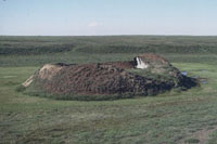
Collapsing pingo
© Parks Canada / 1988
When a pingo is growing, the ground stretches to accommodate its increasing surface area. The tundra splits apart in places, forming cracks – usually along the length of the pingo, especially near its summit – that may reach down as far as the ice core. If these cracks are large enough, the top of a pingo will resemble a crater. Sometimes water ponds in the crater, and this may begin to melt the ice core. More commonly, uplift of the sides of the pingo creates steep slopes that may become unstable and begin to erode. If the ice is exposed to the sun, the core will begin to melt. As its main support melts away, the pingo collapses.

Collapsed pingo
© Parks Canada
When the ice core has completely melted, all that remains is a doughnut-shaped ring of raised tundra enclosing a small round lake. In warmer regions, such as Ireland and the Netherlands, remnants of collapsed pingos have helped scientists determine that the climate was once cold enough in these areas to support a permafrost environment.
Source: http://www.pc.gc.ca/eng/docs/v-g/pingo/sec3/natcul1.aspx
And here is new video and pictures from the Siberian Times:


The hole is in the Yamalo-Nenets Autonomous, some 30 kilometres from the Bovanenkovo gas field. Pictures: Marya Zulinova, press service of the Governor YaNAO
More here: http://siberiantimes.com/science/casestudy/news/first-pictures-from-inside-the-crater-at-the-end-of-the-world/
UPDATE: A look at Google Earth for Yamalo-Nenets Autonomous reveals something like Minnesota’s Land-O-Lakes, but looks a lot like Land-O-Holes. See sat image:

Pulled up the Yamal Peninsula on google earth the other day after the first reports came out and saw they had those holes and ponds all over the place. Just a natural re-occurring phenomenon.
There are several similar features nearby. Wonder how deep they might be.
Look at the vegitation right up to the edge and the heavily eroded walls of the crater.
As I said yesterday, this feature is not new. Even without knowing the geology , I would guess that kind of erosion is centuries old.
I suspect that there is some relationship between these and ice lenses that form under paved roads and cause the surface of the road to lift across the width of the pavement (this is North American usage of “pavement” to refer to the roadway used by motor vehicles; it may have a different meaning in the UK, Australia, etc.). Our country road in eastern Canada has dozens of these, and driving on them in late winter is rough!
Ian M
Definitely aliens.
I think there is an error on the origin of the second from last photo ( cribbed from siberiantimes.com ).
It seems to be very different geology, rock rather than permafrost, and physically too different to be a photo of the same location. That kind of erosion would take centuries.
Still the vegetation around the rim shows that this feature has been building for a long time.
this is a recent _discovery_ not a recent event.
Could this be the crash site of MH370 !? They never did find it and it would be cool to blame the Russians for this one too.
It looks very similar in shape to the hole in the ground in Pennsylvania.
When one has no knowledge of the past, or willfully ignores said past;
Then it is always Unprecedented.
Perhaps it is way past time we focussed on the insanity of these credulous twits and just laugh at them.
Where are the modern satirists?
Hashtag; I am a moron?
Aliens!?!
Ian L. McQueen says:
July 18, 2014 at 7:40 am
I suspect that there is some relationship between these and ice lenses that form under paved roads and cause the surface of the road to lift
Yes , there may be some mileage in that idea.
A bit like a glass bottle bursting as it freezes outside: the top forms a bung and then expansion as the lower water expands as it approaches freezing forces outwards. That is presumably the pingo mechanism that produces the characteristic raised ring.
This implies that the surrounding ground is not solid rock ( although there appears to be a lot of rock in it ). Permafrost would yield under the pressure.
plagarizing a bit:
‘Inside every global warming scare is a natural occurance struggling to be grasped.”
MaxedOutMama said:
July 15, 2014 at 7:51 pm
It’s a pingo sinkhole…
—————-
We have a winner!
A much better explanation.
Neither salt nor water are ignitable. CH4 ignites between 5%(LEL) and 15% (UEL) in AIR with a source of ignition. You cannot ignite a methane between 5% and 15% volume in air by compression, e.g., the cylinder of a diesel engine unless you have a secondary ignition source such as a “pilot charge” of oil. Below and above the flammable limits it won’t ignite. Her explanation had a few holes in it.
Ian L. McQueen says:
July 18, 2014 at 7:40 am
The language is an engineering one, so its meaning is pretty similar here in the UK. Sometimes we just say bitmac or macadam or roadway & at times pavement!
Anyway, isn’t NATURE just blooming marvellous, such fantastic sculpturing of the rock. Looks to me as though it’s been there for a while, certainly beneath the surface if not at the surface! It also looked like the water at the bottom of the hole was fairly shallow as it looked like one could see the rock beneath it, then again may just be me, after all it’s approaching 5pm on a hot sticky Friday afternoon, beer time beckons! HAGWE folks!
Gigantic moles!
I’d never heard of a pingo before, but it sounds like a plausible explanation. And a helluva lot more likely than ‘global warming’, which is a somewhat implausible theory since there hasn’t been any for nearly 18 years.
Hang on, though, maybe Yamal-based pingos have a special 20-year delay feature before they collapse – and so perhaps, this one was merely responding to a slight increase in global temperature from way back in the mid-’90’s.
I mean, they’ve got some fairly special trees over that way too, I hear. Or was it just one?
/sarc.
What I noticed from the latest video posted over at the original article was the clothes the people were wearing. Mid July, northern Hemisphere, and they are dressed like it is November!
Siberia is a cold place!
Nah, it’s a Russian mafia boss’s Sarlac pit.
I agree, that 2nd from last picture is NOT the same crater.
REPLY: I’m sorry, but you are wrong on this claim. You can match up the water etched paths on the rim and walls with the other photos. Just different lighting conditions, like the sun coming out from behind a cloud – Anthony
The reaction to this incident demonstrates that for many Global Warming is not a theory nor an hypothesis, but a superstition. Global Warming is is not the new normal, it’s the new Devil.
Next thing you know this thing will be responsible for slowing down the Gulf Stream.
In southern New England where the freeze-thaw cycle repeats often in the winter, we call these thing potholes.
Let’s learn from this, and figure out how to use injection wells to dig big caverns for us.
Are you sure that isn’t really a diagram of a sebaceous gland?
@ur momisugly Resourceguy –
You know… that theory doesn’t sound entirely implausible. I bet you could get a research grant to study that…