
Image Credit NASA – Polar Vortex on Venus
WUWT Regular “Just The Facts”
Currently there is a lot of media hype about the Polar Vortex over North America, but little in the way of coherent explanation as to what a Polar Vortex is and how it affects Earth’s temperature. As such, a Polar Vortex is “caused when an area of low pressure sits at the rotation pole of a planet. This causes air to spiral down from higher in the atmosphere, like water going down a drain.” Universe Today “A polar vortex is a persistent, large-scale cyclone located near one or both of a planet’s geographical poles.” “The vortex is most powerful in the hemisphere’s winter, when the temperature gradient is steepest, and diminishes or can disappear in the summer.” Wikipedia In addition to those on Earth, Polar Vortices also have been sighted on Venus, Mars, Jupiter , Saturn and Saturn’s Moon Titan.
“Long-term vortices are a frequent phenomenon in the atmospheres of fast rotating planets, like Jupiter and Saturn, for example. Venus rotates slowly, yet it has permanent vortices in its atmosphere at both poles. What is more, the rotation speed of the atmosphere is much greater than that of the planet. “We’ve known for a long time that the atmosphere of Venus rotates 60 times faster than the planet itself, but we didn’t know why. The difference is huge; that is why it’s called super-rotation. And we’ve no idea how it started or how it keeps going.
The permanence of the Venus vortices contrasts with the case of the Earth. “On the Earth there are seasonal effects and temperature differences between the continental zones and the oceans that create suitable conditions for the formation and dispersal of polar vortices. On Venus there are no oceans or seasons, and so the polar atmosphere behaves very differently,” says Garate-Lopez.” Phys.org
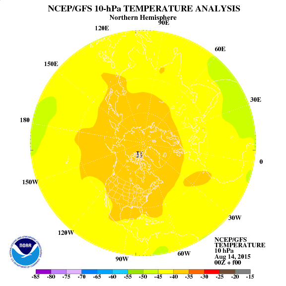
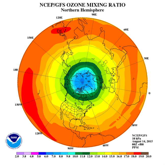
So with that background, let’s take a look at the Polar Vortex currently over North America. Starting at 10 hPa/mb – Approximately 31,000 meters (101,700 feet) here we have a Height Analysis showing the low pressure area;

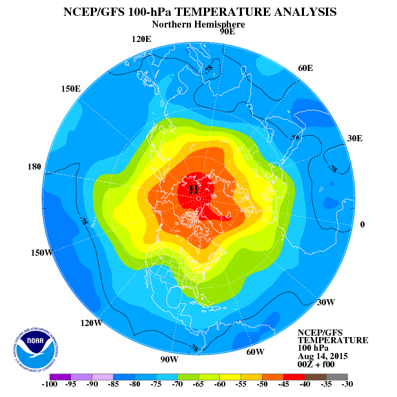
a Temperature Analysis showing the cold area;
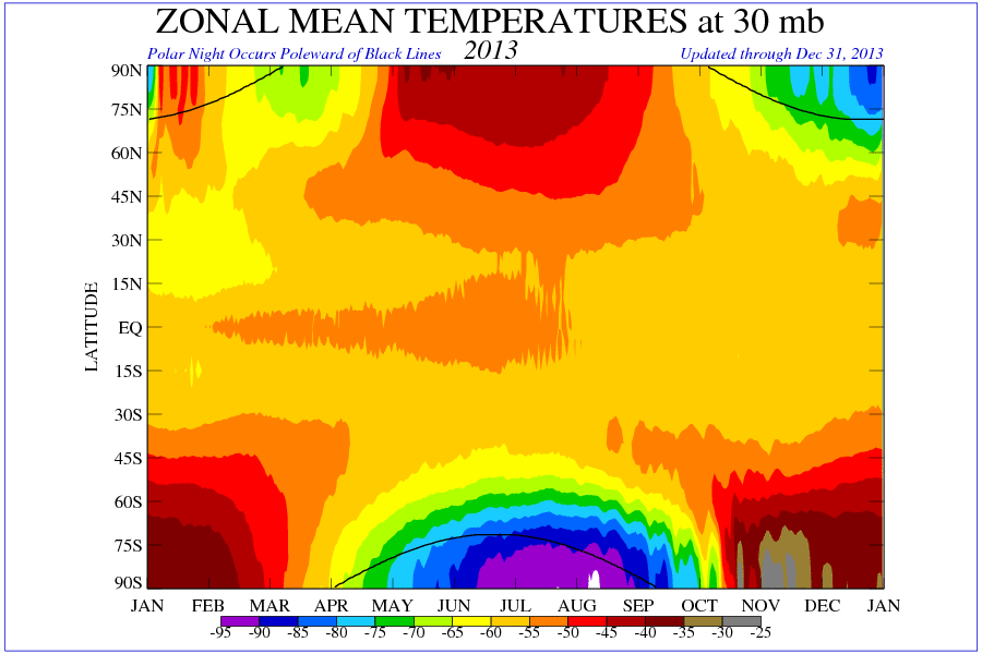
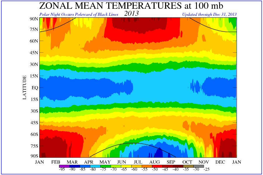
Zonal Mean Temperatures showing the cold area from a global perspective;

a wide perspective Wind Animation and more focused Wind Animation showing the motion of the Vortex,
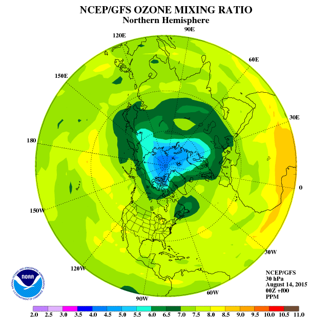
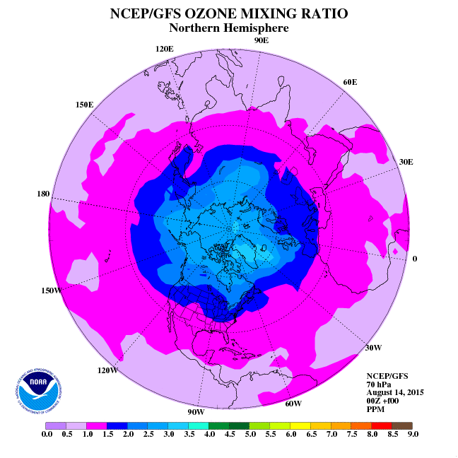
and Ozone Mixing Ratio map showing the “Ozone Hole” within it:
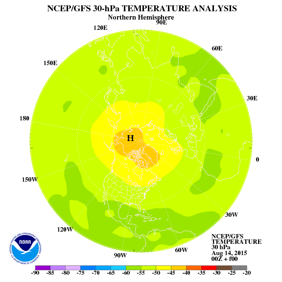
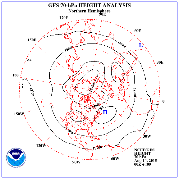
Now we are going to travel down the Polar Vortex in several steps, so here’s another Height Analysis showing the low pressure area at 30 hPa/mb – Approximately 23,700 meters (77,800 feet);

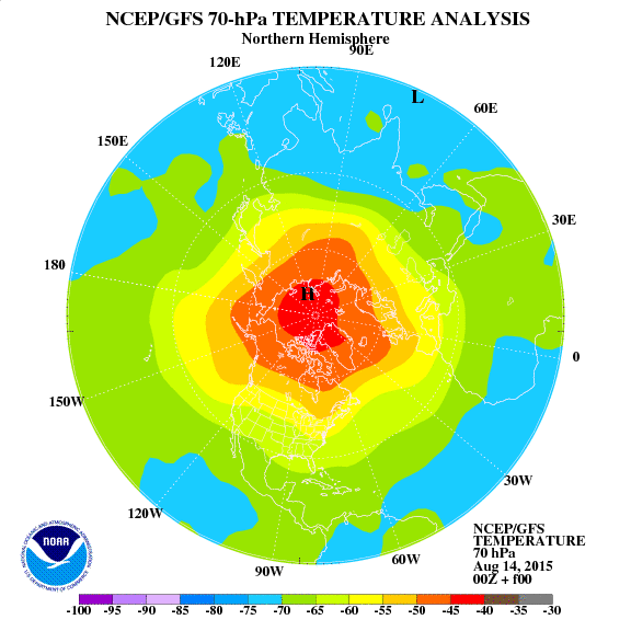
a Temperature Analysis showing the cold area;
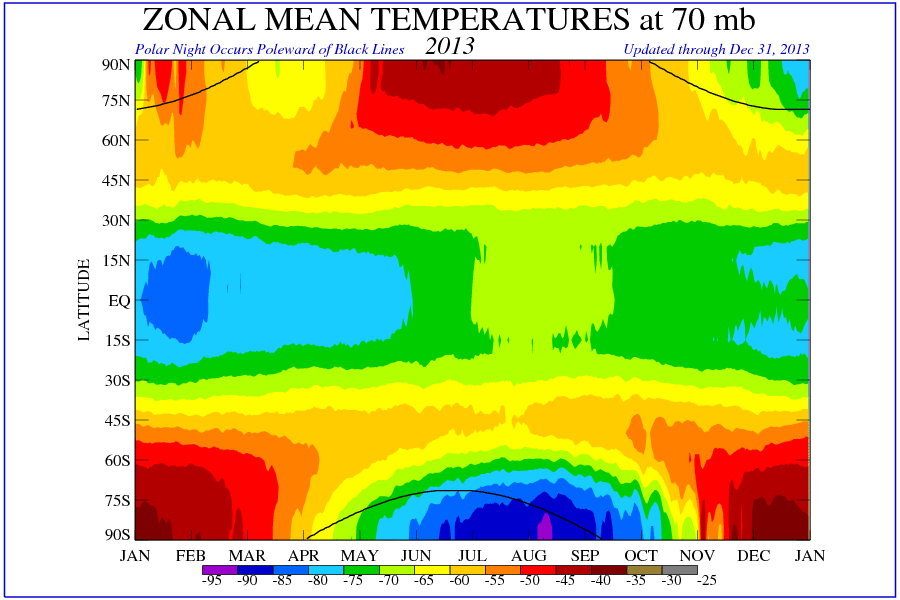
Zonal Mean Temperatures showing the cold area from a global perspective;
and Ozone Mixing Ratio map showing the “Ozone Hole” within the Vortex:
Here’s a Height Analysis showing the low pressure area at 70 hPa/mb – Approximately 18,000 meters (59,000 feet);
a Temperature Analysis showing the cold area;
Zonal Mean Temperatures showing the cold area from a global perspective;
a wide perspective Wind Animation and more focused Wind Animation showing the motion of the Vortex,;
and Ozone Mixing Ratio map showing a slight “Ozone Hole” within it:
And here’s here we have a Height Analysis showing the low pressure area at 100 hPa/mb – Approximately 15,000 meters (49,000 feet);

a Temperature Analysis showing the cold area;
Zonal Mean Temperatures showing the cold area from a global perspective;
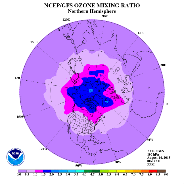
and Ozone Mixing Ratio map showing a slight “Ozone Hole” within the Vortex:
Per this Northern Hemisphere – Vertical Cross Section of Geopotential Height Anomalies you can see that the Polar Vortex currently extends to approximately 100 hPa/mb:
")
also reflected in this Northern Hemisphere – Area Where Temperature is Below 195K or -78C:
")
So why is it so cold in North America right now? Per Global – 10-hPa/mb Height Temperature Anomalies – Atmospheric Temperature Anomalies At Approximately 31,000 meters (101,700 feet);
")
it appears that that we are having an [Upper Stratosphere Lower Mesosphere (USLM) Disturbance] that could lead to a Sudden Stratospheric Warming growing over East Asia, i.e. “the breakdown of the polar vortex is an extreme event known as a sudden stratospheric warming, here the vortex completely breaks down and an associated warming of 30-50 degrees Celsius over a few days can occur. The Arctic vortex is elongated in shape, with two centres, one roughly over Baffin Island in Canada and the other over northeast Siberia. In rare events, the vortex can push further south as a result of axis interruption, see January 1985 Arctic outbreak.” Wikipedia ”The January 1985 Arctic outbreak was a meteorological event, the result of the shifting of the polar vortex further south than is normally seen. Blocked from its normal movement, polar air from the north pushed into nearly every section of the eastern half of the United States, shattering record lows in a number of states.” Wikipedia This BBC Article and Video are helpful in understanding Sudden Stratospheric Warmings. (Note that the text within the [brackets] above has been added and the struck-through removed to correct the article based upon learnings from this comment and this comment below.)
In terms of claims that “US polar vortex may be example of global warming” Guardian and “Polar Vortex: Climate Change Could Be the Cause of Record Cold Weather” Time, these appear to be unsupported conjecture as:
“Many atmospheric general circulation models (GCMs) and chemistry–climate models (CCMs) are not able to reproduce the observed polar stratospheric winds in simulations of the late 20th century. Specifically, the polar vortices break down too late and peak wind speeds are higher than in the ERA-40 reanalysis. Insufficient planetary wave driving during the October–November period delays the breakup of the southern hemisphere (SH) polar vortex in versions 1 (V1) and 2 (V2) of the Goddard Earth Observing System (GEOS) chemistry–climate model, and is likely the cause of the delayed breakup in other CCMs with similarly weak October-November wave driving.”
“In the V1 model, the delayed breakup of the Antarctic vortex biases temperature, circulation and trace gas concentrations in the polar stratosphere in spring. The V2 model behaves similarly (despite major model upgrades from V1), though the magnitudes of the anomalous effects on springtime dynamics are smaller.”
“Clearly, if CCMs cannot duplicate the observed response of the polar stratosphere to late 20th century climate forcings, their ability to simulate the polar vortices in future may be poor.”
“It is unclear how much confidence can be put into the model projections of the vortices given that the models typically only have moderate resolution and that the climatological structure of the vortices in the models depends on the tuning of gravity wave parameterizations.
Given the above outstanding issues, there is need for continued research in the dynamics of the vortices and their representation in global models.”
To learn more about Polar Vortices please visit the WUWT Polar Vortex Reference Page.
I’ll have to re-read this, but it was interesting. Thanks Anthony (& WUWT team).
Gene
So a large chunk of air is moved pole ward, loses energy then is squeezed south, right?
Isn’t that how it is supposed to work?
“but little in the way of coherent explanation as to what a Polar Vortex is and how it affects Earth’s temperature. “
Wow. And your 50 graphs helped? I don’t think so. And the fact that you don’t mention the jet stream? Amazing.
At least for Finland those pictures are lacking reality. Basically it has been +/-0 to +3 celsius here for the last month or so. I can agree that we’re “enjoying” the low pressure of that vortex, but the temperature map doesn’t match at all. Luckily, within few days we’re going to have more normal winter temps here.
Really good presentation – wow – very interesting. Just perusing the net today must have seen a thousand different explanations for this.
Looks a lot like the movie: “The day After Tomorrow”…
Thanks for the information overload. I mean that. Thanks. For those who haven’t discovered this, the wind animation can be zoomed and rotated. I was able to get a close up of the winds we’ve had here at my little house on a point on Lake Erie.
@DocWat
LOL! I was thinking the same thing.
So where is James Hansen when you really need him?
Pippen Kool says: January 7, 2014 at 7:39 pm
Wow. And your 50 graphs helped?
15 graphics for the record, but regardless, maybe a video would help? This animation shows Earth’s Winter 2008 – 09 Arctic Polar Vortex breakup and a Sudden Stratospheric Warming: [youtube=http://www.youtube.com/watch?v=mIXfYTSmBg0&feature=related]
And the fact that you don’t mention the jet stream? Amazing.
What about the Jet Stream? What are you amazed about?
Box of Rocks says: January 7, 2014 at 7:38 pm
So a large chunk of air is moved pole ward, loses energy then is squeezed south, right?
Isn’t that how it is supposed to work?
I think it’s much more involved than that, i.e. a Stratospheric Vortex forms during the polar night and cold “Air from very high altitudes descends vertically through the center of the vortex, moving air to lower altitudes over several months.” NASA The Polar Vortex is then buffeted by Eddy Heat Flux i.e.:
As such, here’s 10 day Averaged Eddy Heat Flux Towards The North Pole At 100mb; NOAA – National Weather Service – Climate Prediction Center – Click the pic to view at source[/caption]
[caption id="" align="alignnone" width="578"]
you can see the recent spike. The breakdown of the Polar Vortex is an unpredictable and extremely chaotic event, e.g. sometimes the Polar Vortex and associated “Ozone Hole” can split in two, i.e. per this September 2003 paper on the SOuther Polar Vortex, “Ozone Forecasts of the Stratospheric Polar Vortex Splitting Event in September 2002″: http://www.knmi.nl/~eskes/papers/jas1039_eskes_pp.pdf
“The ozone hole is in the center of a spiraling mass of air over the Antarctic that is called the polar vortex. The vortex is not stationary and sometimes moves as far north as the southern half of South America, taking the ozone hole with it.”
http://www.nasa.gov/centers/langley/news/factsheets/HALOE-Ozone.html
In summary, I think the answer is it depends, i.e. on how well developed the Polar Vortex is, how it breaks up, when it breaks up, where it is when it breaks up, the conditions outside of it when it breaks up, and a bunch of other factors that we do not yet understand, hence why we haven’t figure out how to model the Polar Vortex breakdown process yet.
And even if the AGW theory were supported by climate models (which this article shows it isn’t), the graphs of the Arctic sea ice extent during this summer show it close to the 30 year average. Time for Michael Mann to call an AGW cult team huddle to rally around “the cause” – http://cosmoscon.com/2014/01/07/time-for-an-agw-cult-team-huddle/
Answer to Halo , January 7, 2014 at 7:41 pm
The situation in Finland (and Sweden) is a result of two factors:
* the eruptions in Iceland vulcanos the other year
* today’s Northern Polar Vortex was ‘born’ five years ago and due to the complexe systems mentioned above, including jet streams, as well as our Earth wobbling. All that happened after the Polar Wortex of today was ‘born’ including the vulcanos eruption under water south Alaska which caused inflow of water from the Pacific. Water of other density and higher saltpercentage.
“What about the Jet Stream? What are you amazed about?”
The vortex is bounded by the jet stream which has, for some reason (blink blink wink wink) has wandered south. This was documented in the vortexes of 2006, 2009 and 2010, so I think that any intelligent discussion of polar vortexes requires an explanation of what is happening to the jet-stream. Or are you alarmed that this might bring up those scary AGW hypotheses, best ignored?
Reblogged this on A TowDog and commented:
At last, an explanation for the dreaded “ArcticSharkVortexNado” that’s based on science instead of breathless media hype
cosmoscon says: January 7, 2014 at 8:31 pm
And even if the AGW theory were supported by climate models (which this article shows it isn’t), the graphs of the Arctic sea ice extent during this summer show it close to the 30 year average. Time for Michael Mann to call an AGW cult team huddle to rally around “the cause” – http://cosmoscon.com/2014/01/07/time-for-an-agw-cult-team-huddle/
Yes, good point;
This animation demonstrates the increase in ice thickness measured by CryoSat over the last four Octobers: European Space Agency – CryoSat – Click the pic to view at source[/caption]
 National Snow & Ice Data Center (NSIDC) – Click the pic to view at source[/caption]
 Cryosphere Today – Arctic Climate Research at the University of Illinois – Click the pic to view at source[/caption]
[caption id="" align="alignnone" width="564"]
Also, Arctic Sea Ice Extent remained within two standard deviations of the 1981 – 2010 average for the entirety of 2013;
[caption id="" align="alignnone" width="640"]
and Northern Hemisphere Sea Ice Area saw its smallest decline since 2006, with a decline less than half of the prior year and it ended 2013 less than .5 Million Sq Km below the 1979 – 2008 average;
[caption id="" align="alignnone" width="640"]
Furthermore, if you look at the graph above last time this type of event occurred, i.e. the “January 1985 Arctic outbreak”, Arctic Sea Ice Area appears quite close to average, so it appears spurious to attribute this type of event to declining Arctic Sea Ice.
norah4you says: January 7, 2014 at 8:31 pm") NOAA – National Weather Service – Climate Prediction Center – Click the pic to view at source[/caption]
NOAA – National Weather Service – Climate Prediction Center – Click the pic to view at source[/caption]
Answer to Halo , January 7, 2014 at 7:41 pm
The situation in Finland (and Sweden) is a result of two factors:
* the eruptions in Iceland vulcanos the other year
* today’s Northern Polar Vortex was ‘born’ five years ago and due to the complexe systems mentioned above, including jet streams, as well as our Earth wobbling. All that happened after the Polar Wortex of today was ‘born’ including the vulcanos eruption under water south Alaska which caused inflow of water from the Pacific. Water of other density and higher saltpercentage.
What? That’s impressively incoherent. “Today’s Northern Polar Vortex was ‘born’” in December 2013, i.e. Northern Hemisphere – Area Where Temperature is Below 195K or -78C;
[caption id="" align="alignnone" width="578"]
due to factors we do not fully understand, but the Coriolis Effect;
http://en.wikipedia.org/wiki/Coriolis_effect
is the biggest factor in the equation.
An excellent article , thanks.
Guardian article regurgitating article Andrew Freedman at Climate Central :
“Cohen published a study in September that found this Arctic paradox pattern has become common in years with low fall sea ice cover and rapidly advancing fall snow cover across parts of Asia, and that there is a likely link between the trends. The paper found the pattern was observed during the winter of 2012-2013, following the lowest fall sea ice extent on record in September 2012.”
So Freedman sees no problem in applying conclusions of a “paper” in a magazine called TOS. linking low arctic ice coverage and such events. to a year with average arctic ice extent.
I guess that’s what they mean by “counter-intuitive”, a terms that seems to be “trending” recently.
How often during winter does the jet stream wander far south? Does it ever wander very far north? During its excursion south in one place does it wander far north in other places. Do you have a large enough sample of jet stream behavior to justify your winking?
Corioli Pippen Kool says: January 7, 2014 at 8:34 pm
The vortex is bounded by the jet stream which has, for some reason (blink blink wink wink) has wandered south. This was documented in the vortexes of 2006, 2009 and 2010, so I think that any intelligent discussion of polar vortexes requires an explanation of what is happening to the jet-stream.
This a question of what’s the dog and what’s the tail. In this case, the dog is likely the Polar Vortex and Jet Stream is likely the tail, i.e. the Jet Stream didn’t “wander”, but rather it was moved by the Polar Vortex. Take a look at this animation;
http://eoimages.gsfc.nasa.gov/images/imagerecords/36000/36972/npole_gmao_200901-02.mov
and review this page;
http://earthobservatory.nasa.gov/IOTD/view.php?id=36972
to see what a Vortex break up looks like. It doesn’t look like the jet stream is doing much “bounding”.
Or are you alarmed that this might bring up those scary AGW hypotheses, best ignored?
No, please take a look at this article;
http://wattsupwiththat.com/2014/01/04/2013-was-not-a-good-year-for-catastrophic-anthropogenic-global-climate-warming-change-disruption-wierding-ocean-acidification-extreme-weather-etc/
and let me know if there are any more of “those scary AGW hypotheses” you’d like me to poke holes in next.
JTF: “Furthermore, if you look at the graph above last time this type of event occurred, i.e. the “January 1985 Arctic outbreak”, Arctic Sea Ice Area appears quite close to average, so it appears spurious to attribute this type of event to declining Arctic Sea Ice.”
That also appears to have a year with unusually small annual variation. Possibly the lowest in the record.
Just on casual observation, it looks to me like the round shape of the simple votex is being squeezed between two highs. The strongest one being in North Pacific.
That would appear to be what is causing the deformation leading to the bulge now extending into N. Am.
This hotspot seems to have its origins well up in the stratosphere.
I would also note that we just past perihelion at the same time as new moon. This will be a time of maximum tidal forces, which affect both oceans and atmosphere.
I’m currently trying to find out the state of the perigee cycle to see whether earth-moon distance is also adding to this.
Pippen Kool says:
January 7, 2014 at 8:34 pm
“What about the Jet Stream? What are you amazed about?”
The vortex is bounded by the jet stream which has, for some reason (blink blink wink wink) has wandered south. This was documented in the vortexes of 2006, 2009 and 2010, so I think that any intelligent discussion of polar vortexes requires an explanation of what is happening to the jet-stream. Or are you alarmed that this might bring up those scary AGW hypotheses, best ignored?
———————————
You seem to think that the jet stream is doing something unusual. What would make you think that?
If you read the “Joe’s” on WxBell professional, the likelyhood of the polar vortex dropping over central NA is correlated to the phase of the QBO, AO/NAO & the ENSO (neutral) cycles. If I read their posts correctly, they expect it will drop into the US again before the end of winter due to the combination of the above factors.
Box of Rocks says:
January 7, 2014 at 7:38 pm
So a large chunk of air is moved pole ward, loses energy then is squeezed south, right?
Isn’t that how it is supposed to work?
++++++++++++++++++++++++++++++++++++++
Essentially the polar vorticies (Usually two high pressure interacting with one massive low.) are a massive Heat Transfer in action. This is one of the major driving forces of our planets cooling system and appears to be directly related to upper atmosphere cooling. The air exchange allows black body radiation high into our atmosphere and escape into space. IN times of low solar output the upper atmosphere cools and the down welling of cold interacts with the up welling of warm. Somewhat like a dryline works and causes two distinct areas of rotation, one warm and one cold.
This shoving match soon enlarges to the point the rotation is unstable and like a top is shoved OR wanders off point. When this happens the vortex weakens or collapses and the upwelling warmer air rushes over top of the low disrupting it briefly. After a short period the upper cold air forces its way to the earths surface while the earths rotation resumes the low pressures rotation and the process essentially starts over.
If you look into the history presented by JTF these major cooling spells, sub arctic air intrusion and record breaking low temps have been during times of low solar output and colder air aloft over the poles. During times of higher solar activity the air masses above the poles is warmer and the reduced differential does not allow these vorticies to grow in size. (and incidentally tropical vorticies increased in size)
One could hypothesize that a cooling planet will have greater differential above the poles and thus cooling would be thrust outward to the equator. Even though the temps (at the poles) may moderate, the globe as whole is cooling. Inversely, if the air above the poles is warmer due to an active solar cycle, ADO, PDO, etc the warming reduces the temperature imbalance (at the poles) and thus the polar vortex is reduced in size keeping cooling localized.
Meh. It’s happened before. It will happen again.
It is amusing, though. After the Warmists realized they really couldn’t get away with labeling every heat spell a sign of AGW, and every cold snap mere weather, they decided to coopt the cold snaps to The Cause as well. I wonder how many suckers will fall for the ploy?