 Vancouver, Washington (March 22nd 2012) – “Many cities across Western Oregon and Southwest Washington are setting all-time cold and snowfall records for this late in the season. Since Tuesday night, the Willamette Valley has been blanketed with anywhere from 2″ to 9″ of snow from Vancouver, WA. south to Eugene, Oregon.
Since Tuesday evening, many all-time March snowfall and temperature records have been broken up and down the Willamette Valley at airport locations. Portland, Salem, Eugene and Vancouver, WA. airports all set new coldest daytime high temperature records on Wednesday in addition to setting new all-time records for the heaviest snowfall this late in the season. Eugene, Oregon easily broke their maximum daily precipitation record for Wednesday with 1.92 inches with equated to a record setting 7.5″ of snowfall on Wednesday.”
“The Portland International Airport recorded 0.5″ of snowfall overnight last night which sets a new all-time record for that location. March 22nd 2012 will now go down in the record books as the latest measurable snowfall in Portland Airport history. The period of record at the Portland airport is 1940-2012.
The previous latest snowfall on record for the Portland airport was set on March 15th 1946. The excellent staff at the Portland office of the National Weather Service have reviewed daily records that previously indicated both March 20th 1995 and March 25th 1965 as the latest dates for measurable snowfall in Portland.
These reports were in fact hail, not snow! Hail was often reported under the snow column on the record sheets. Looking even further back, downtown Portland records indicate that as much as 5″ of snow fell in the first week of April in 1936. Records in downtown Portland date back to 1872. It is hard to believe that spring break is just 24 hours away for Oregon students.”
###
Image added by Anthony – source: http://www.nohrsc.noaa.gov/nsa/index.html?year=2012&month=3&day=22&units=e®ion=Northwest
Info/PR from: Steve Pierce President, Oregon Chapter of the American Meteorological Society
Oregon AMS web site: http://www.ametsoc.org/chapters/oregon/
E-mail: stevejpierce at comcast.net Phone: 503-504-2075
Here’s the official NWS record:
=================
 RERPQR

 RECORD EVENT REPORT

 NATIONAL WEATHER SERVICE PORTLAND OREGON

 840 AM PDT THU MAR 22 2012

 ...RECORD SETTING LATE SNOW EVENT FOR MUCH OF WILLAMETTE AND LOWER

 COLUMBIA RIVER VALLEY AREA OVER THE LAST 36 HOURS...

 A FRONT STALLED OVER SOUTH LANE AND NORTH DOUGLAS COUNTY TUESDAY

 NIGHT...THEN LIFTED NORTH A BIT BEFORE HEADING EAST OF THE

 CASCADES. HEAVY PRECIPITATION FELL ACROSS THE REGION...BUT NORTH OF

 THE FRONT SNOW LEVELS WERE VERY LOW...WITH HEAVY SNOW THE RESULT IN

 THE SOUTH AND CENTRAL VALLEY YESTERDAY...AND THE CENTRAL AND NORTH

 WILLAMETTE VALLEY INTO CLARK COUNTY OVERNIGHT. HEAVY SNOW ALSO FELL

 IN THE CASCADES DURING THIS TIME PERIOD...WITH 1 TO 3 FEET OF SNOW

 OVER THE HIGHER CASCADES.

 WITH THE HEAVY WET SNOW...MANY AREAS HAVE EXPERIENCED DOWNED POWER

 LINES RESULTING IN SCATTERED POWER OUTAGES. IN ADDITION...MANY TREE

 BRANCHES HAVE BEEN BROKEN BY THE WEIGHT OF THE WET SNOW. THIS EVENT

 WILL BE ONE THAT LOCAL RESIDENTS WILL NOT SOON FORGET.

 =============================================================

 ACROSS CITY OF PORTLAND...  0.5 TO 3 INCHES...BUT 3 TO 7 INCHES

 OVER THE HIGHER HILLS OF THE METRO AREA.

 AT PORTLAND NATIONAL WEATHER SERVICE OFFICE (NEAR THE AIRPORT)...

       ***  STORM TOTAL....         0.5 INCH OF SNOW

 THIS IS A RECORD LATEST MEASURED SNOWFALL AT THE AIRPORT.

  ** 2012  MARCH 22          0.5 INCH   *** NEW RECORD ***

     1946  MARCH 15          0.5 INCH   PREVIOUS RECORD

 RECORDS SHOW 0.4 INCH IN 1995 AND 0.3 INCH IN 1965...BUT BOTH OF

 THESE EVENTS WERE SMALL HAIL ACCUMULATIONS.

 HERE IS HOW IT COMPARES TO OTHER LATE SEASON SNOW EVENTS

 (WITH STORM TOTALS).

  ** 2012  MARCH 21-22       0.5 INCHES

     1950  MARCH 10          0.8 INCH

     1951  MARCH 3-10       12.9 INCHES

     1956  MARCH 5           1.8 INCHES

     1960  MARCH 2-3         2.6 INCHES

     1989  MARCH 1-2         2.0 INCHES

 OF NOTE... DOWNTOWN PORTLAND HAS RECEIVED MEASURABLE SNOW IN

 APRIL...WITH THE LARGEST EVENT OCCURRING IN 1936 WHEN 5.2 INCHES

 FELL ON APRIL 1...WITH THAT STORM TOTAL OF 6.8 INCHES (MARCH 28

 THROUGH APRIL 1). THE LATEST THAT DOWNTOWN HAS RECEIVED MEASURABLE

 SNOW WAS APRIL 14 1924...WHEN  0.1 INCH OF SNOW FELL IN DOWNTOWN

 PORTLAND.

 ON AVERAGE...PORTLAND AIRPORT RECEIVES 0.2 INCH OF SNOW IN MARCH.

 SNOWFALL RECORDS AT THE AIRPORT DATE BACK TO 1940. DOWNTOWN RECORDS

 DATE BACK TO 1872.

 =============================================================

 CITY OF EUGENE...  6 TO 10 INCHES...HEAVIEST IN SOUTH HILLS.

 AT THE EUGENE AIRPORT...

       ***  STORM TOTAL....         7.5 INCHES OF SNOW

 THIS IS THE BIGGEST SNOWSTORM TO STRIKE THE EUGENE AREA THIS LATE

 IN THE WINTER SEASON. HERE IS HOW IT COMPARES TO OTHER RECORD LATE

 SNOWFALLS OF THE WINTER SEASON (WITH STORM TOTALS).

  ** 2012  MARCH 20-21       7.5 INCHES

     1951  MARCH 5-7         7.6 INCHES

     1916  MARCH 3-4        13.7 INCHES

 HOWEVER...IT IS NOT THE LATEST MEASURED SNOWFALL. THE LATEST

 MEASURABLE SNOWFALL OF THE WINTER SEASON AT THE EUGENE AIRPORT...

     1911  APRIL 13          0.3 INCH

 ON AVERAGE...EUGENE RECEIVES 0.5 INCH OF SNOW IN MARCH.

 RECORDS FOR EUGENE DATE BACK TO 1892.

 =============================================================

 AROUND THE CITY OF SALEM...   2 TO 7 INCHES OF SNOW FELL...

 WITH THE HIGHEST AMOUNTS ON THE HILLS IN SOUTH SALEM.

 AT THE SALEM AIRPORT...

       ****  STORM TOTAL....         2.5 INCHES OF SNOW

 THIS IS THE BIGGEST SNOWSTORM TO STRIKE SALEM THIS LATE IN

 THE WINTER SEASON. HERE IS HOW IT COMPARES TO OTHER RECORD

 LATE SNOWFALLS OF THE WINTER SEASON (WITH STORM TOTALS).

  ** 2012  MARCH 21-22       2.5 INCHES

     1951  MARCH 5-9         9.6 INCHES

     1960  MARCH 3-4         8.5 INCHES

 BUT THIS IS NOT THE LATEST MEASURED SNOWFALL. THE LATEST

 MEASURABLE SNOW EVENTS OF THE WINTER SEASON AT SALEM AIRPORT...

     1920  MARCH 31          1.5 INCHES

 ON AVERAGE...SALEM RECEIVES 0.3 INCH OF SNOW IN MARCH.

 RECORDS FOR SALEM DATE BACK TO 1892.

 ===============================================================
And here in southern New England we’re hitting 80 degrees with little spring rain.
Does this mean more snow melt and runn off that will be diverted away from the irrigation farming?
OK, but this won’t make the MSNBC front page. Too inconvenient.
Wow! Two to nine inches of global warming!
La Nina started work about six weeks late this winter, so she needs six weeks at the end to finish her job.
Memo to Mother Nature: It’s spring darn it! What’s this white stuff on my flowers?
Anchorage, Alaska, is within striking distance:
http://pafc.arh.noaa.gov/pubfcst.php?fcst=NOAK48PAFC
Perhaps this weekend:
http://forecast.weather.gov/MapClick.php?zoneid=AKZ101
The good news is that the jet stream has shifted back north to the US-Canada border, where it continues on up towards Labrador. Perhaps that will help moderate the weather in the west.
Meanwhile, thanks to that jet stream, Buffalo yesterday had an all time high for the month of March of 82°F. We’ve already had a string of over 10 days of above 60°F high temps, compared to the normal high temp of approx 45°F. Of course, since this is just weather, there’s nothing to prevent the jet stream from developing another wiggle and sending us a blast of cold air and two feet of snow for Easter Sunday.
Global cooling is a threat to our way of life.
Children are just never going to experience what it was like before snow days!!!
Here in in Western Canada we have so much snow (Great skiing /snow boarding) that last night the Government put out a flood advisory for the spring melt off. The snow amount and depth is very similar to the 1970s on the coast mountain range.
I drove home in a pretty good flurry last night. I’m at 300 feet elevation. Had over an inch on the ground this morning! Had my anti-lock breaks kick in entering the parking lot at work. Looks like a lot of people are tele-commuting today.
Had an inch of wet snow on the ground at 6:00am this morning. Still have snow in the shaded areas of the lawn at 11:00am. Located near Fairwood WA, between Renton and Maple Valley, at 560 ft feet above mean sea level. (I’m ‘down’ today, with an incredibly sore throat.) Outside temp 39F, calm, with broken overcast.
We have had far more snowfall days here this winter than I have experienced in the 14 years I have lived here. Over the last 3 weeks, we’ve had snowfalls on 2 – 3 days each week. We are averaging 10F below normal temps for much of February and all of March, so far. The extended forecast says we may hit low 50F next week for daily highs, when average daily highs for this time of year have been high 50’s. I’ll believe it when I feel it!
Areas of the Cascades (Mt. Baker, Snoqualmie Pass, etc) have recorded huge snow fall totals over the last 3 weeks. Mt. Baker is reporting +15 feet for March 1 – 20.
Related to the snow accumulation…
The average of both poles’ global sea ice area is still increasing and rising above the 1979-2008 mean.
I have been calculating the sea ice areas as a percent above or below the 79-08 mean for both poles and averaging them to get a single number.
18mar the average was 103.28 % above the mean
22mar the average is 104.05 % above the mean
The number is currently increasing.
This could be a quick glance indicator to show total ice stability related to the average.
“Many cities across Western Oregon and Southwest Washington are setting all-time cold and snowfall records for this late in the season”
This just can’t be happening, I have watched the weather channel and saw nothing on record cold or snow. In fact they had a fancy graphic on TV and spent 2 minutes talking about… ‘potential record highs’.
/s
Meanwhile in Atlanta, GA we’ve had a very mild winter. The temperature was over 80F (27C) for the St. Patrick’s Day parade March 17th. I’m not used to weather this nice for St. Pat’s (great crown turnout BTW). On the other hand, we just set an all-time high for pollen count this last Monday: over 8,000! (for tree pollen, anything over 1,500 is ranked “very high”).
Interesting times …
Make that “great crowd turnout” above — as far as I know there were no members of the royal family in attendance, but we did have the consul general for Ireland.
“This just can’t be happening, I have watched the weather channel and saw nothing on record cold or snow. In fact they had a fancy graphic on TV and spent 2 minutes talking about… ‘potential record highs. . . . . . .”
Ha! . . living here in Salem, Oregon I can tell you that we had five inches of “potential record highs” last night. In case you’re wondering, “potential record highs” happen to be bright white and cover the ground quite nicely.
I live on a hill at about 400 feet elevation in Salem; this morning about 4 am it was incredibly beautiful with the street lights reflecting off the snow and lighting up the low layer clouds.
According to weather.com, over 4,300 record highs have been compiled in March, and nt small ones — by eight to ten degrees. Any plans for a post about this?
REPLY: Why, is there a dearth of coverage about it in the press? We cover things here that are often ignored by the MSM, I doubt my coverage would make any difference since it has been widely covered already. Try to find any mention of this story about WA and OR anywhere else and let me know if you find any in those outlets that covered the record highs. – Anthony
So, was it the low amount of arctic ice which caused this snow? ‘Cause last I checked we’re right at an 7-8 year high in extent.
According to the BEST QC data (latest release) Portland Airport has been cooling since around 1988.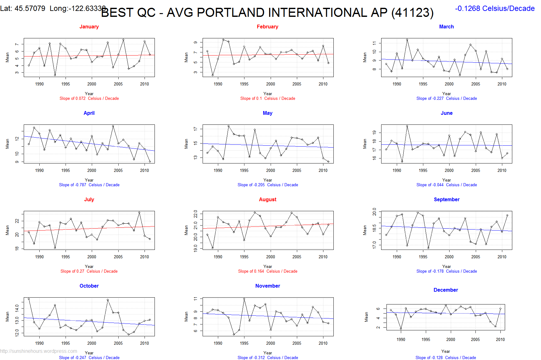
On the other hand, you had 30C on the east coast a few days ago – in freakin’ March, or so the story goes on German news.
“Mercury poles give up hints of water ice”
http://www.bbc.co.uk/news/science-environment-17470151
Interesting
Don’t you know ANYTHING? This is exactly what you’d expect to see with global warming! Duh.
(or so I was told last week)
http://www4b.wolframalpha.com/Calculate/MSP/MSP43231a0h19b1c5b3b36300002b3g6f0ibbaeg956?MSPStoreType=image/gif&s=20&w=475&h=157&cdf=Resizeable
http://www.wolframalpha.com/input/?i=portland+pdx+temperature