Where the !@#$% is Svalbard's Weather Station?

In the previous WUWT entry, Willis posted his data on the Svalbard weather station, noting that it is spliced data and that the station data has been merged in nearby station history:

0 km (*) Svalbard Luft 78.2 N 15.5 E 634010080002 rural area 1977–2006

47 km (*) Isfjord Radio 78.1 N 13.6 E 634010050010 rural area 1912–1980

425 km (*) Bjornoya 74.5 N 19.0 E 634010280003 rural area 1949–2006

Svalbard Luft is the airport. As we’ve noted time and again on WUWT, the stations in GHCN have a propensity for airport migration. Here’s what Svalbard Airport looks like to visitors:

File:Svalbard Airport, Longyear 1.jpg
Svalbard airport terminal and tarmac - Image from Wikimedia - click to enlarge

Lots of nice black asphalt and buildings there to absorb the feeble sunshine at that latitude. But where’s the weather station?

No help from NCDC’s metadatabase, they have no clue either, all they know is that it is “at the airport”:

The equipment tab gives no clues, and the lat/lon is too coarse to pinpoint a location within the airport complex.

But, the great thing about Svalbard is that it is now a tourist destination. Regular jet flights are available. Fortunately for us, tourists take photos, and upload them to Panoramio. Here’s one photo likely taken right off the plane:

Note the Stevenson Screen at the edge of the tarmac

Here are some additional views:

This photo is very high resolution, over 3000 pixels wide, see the zoomed section below
The zoomed image shows the Stevenson Screen at the edge of the tarmac

I found another tourist photo on Panaramio, that shows the characteristic metal legs and struts of the Stevenson Screen visible beyond the plane that tourists are boarding:

Note the legs and bracing struts of the Stevenson Screen are visible - click image for original photo

More tourist submitted Panoramio photos of the airport show just how much asphalt tarmac there is around the station, such as this one:

One tourist uploaded a huge panorama image of the airport tarmac - click for original image

And when you zoom in on that panorama image at far left, sure enough, there’s the Stevenson Screen again:

Stevenson Screen at the edge of the airport tarmac, zoomed subsection of previous image

It is clear that there’s a lot of asphalt around the station, but there’s also a lot of snow too. What happens when it snows at the airport? They clear the runway and tarmac, of course:

Svalbard Luft seen from the air - click for original image

Where’s the Stevenson Screen? Right at the edge of the tarmac.

Svalbard airport terminal and tarmac - Stevenson Screen location is the dot near the end of the arrow

So, aviation snow removal makes a nice black year round albedo, right next to the weather station. Plus jet exhaust, generators, steam driven de-icers and other tools of the aviation trade are also nearby. Even if the Stevenson Screen has been abandoned in favor of an automated sensor, as often happens at airports, both would still have some locally measured effects in the record.

In the Arctic and Antarctic, aviation is the lifeline of humanity. A warm pocket of energy use in a sea of snow and ice. It would be interesting to plant a few of my portable USB logging thermometers around Svalbard away from this pocket of humanity to see what sort or temperature readings we get. By bet is that we’ll see a local AHI (Airport Heat Island) at Svalbard. It’s a busy place. In 2009, the airport had 138,934 passengers. Source: ^ Avinor (2010). “Årsrapport Passasjerer” (in Norwegian). http://www.avinor.no/tridionimages/2009%20Passasjerer_tcm181-109035.xls.

In Willis’ previous essay, he notes RC calls it a 5 sigma outlier event in April 2006. I had surmised it might be due to a tarmac resurfacing changing the albedo. I could be right. From the Wiki article on Svalbard airport:

In 1989, parts of the runway were re-insulated, giving these areas that previously had been the worst an acceptable solution. In 2006, this measure was conducted on the remaining parts of the runway.

There was construction going on in 2006, Oddly the source of that metadata is from a paper on gauging the airport performance under the “duress” of climate change:

Svalbard airport runway. Performance during a climate-warming scenario. (PDF)

In a study initiated by the Norwegian Airport Authorities in 1995, insulation of the whole runway in a manner similar to the 1989 procedure was deemed the most favorable long-term runway maintenance strategy (Instanes, D. and Instanes, A., 1998). This has so far not been carried out, and a new reconstruction is planned for 2005/2006 to improve the runway. The average global surface temperature is projected to increase from 1.4 to 5.8°C between 1990 and 2100 (IPCC, 2001). Warming at higher latitudes of the Northern hemisphere may be greater than the global average, as high as 4 to 7°C between 2000 and 2100 (ACIA, 2004).

They don’t seem to realize anywhere in the paper that the temperature data they are relying of for input to their models used for permafrost thaw comes from the little white box at the edge of the tarmac. Talk about positive feedback and polar amplification. Let’s build a new runway; hey look it’s warmer we were right! Sheesh.

People like Jim Hansen and Gavin Schmidt who sit up at the top of the climate food chain and take data from these weather stations at face value and then use it to extrapolate to nearby grid cells because there are no other nearby stations in the Arctic really need to get out more and see what the measuring environment is like. Maybe somebody can convince them to get off their taxpayer funded butts and away from their computer screens someday and do some field work.

Of course given what they did to censure Willis at RC when he brought up the issues at Svalbard, I doubt they’d believe their own eyes if it contradicted their expectations.

UPDATE:

The UHI at Svalbard airport has been measured, using the driving technique I first wrote about back in fall 2008 to study UHI in Reno, NV.  This study at:

http://climate4you.com/LongyearbyenUHI%2020080331.htm

…was pointed out by commenter Ibrahim and is reproduced below:

=============================================

Longyearbyen UHI experiment, March 31, 2008

Longyearbyen March 31, 2008 16:15 PM (not corrected for summer time), looking WNW from the northern end of the lake Isdammen (see map below). The sky was almost clear, with a few local clouds forming over the fjord. The wind was weak from southeasterly direction, 0.5-3 m/s. The large building in the distance to the right is the main hangar at Svalbard Ariport. Compare with map below.

The general weather situation, measurement equipment and measurement route

The air temperature was about -20oC, and the wind weak from southeasterly direction, 0.5-3 m/s, but with local deviations (see map below). The sky was almost clear. The ground surface was covered by snow. The nearby fjord was ice free, with the exception of a 5-50 m wide zone with new icew along the coast. A thermistor was attached to the roof of a car (c. 1.5 m above terrain), and temperatures were logged at 2 sec. intervals. The time given in the diagrams below are not corrected for summer time. The measurements were carried starting at Svalbard Airport in the upper left of the map below, driving SE along the coast to the town, making a roundtour here, before proceding SE into the lower part of the major valley Adventdalen.

Longyearbyen is the worlds northernmost town and is located at 78o17’N 11o20’E, in central Spitsbergen . The present number of inhabitants is 2,001 (January 1, 2007). There is no official meteorological station located in Longyearbyen at the moment. The official meteorological station is located at the airport, about 4 km northwest of Longyearbyen, close to the coast (see map below).

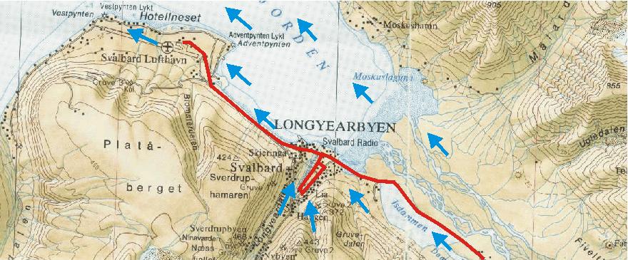
Topographic map showing Longyearbyen and Svalbard Airport (Svalbard Lufthavn). The red line shows the measurement route March 31, 2008, starting at the Airport and ending in the lower part of the valley Adventdalen to the SE. In between, a detour was made in the central part of the town as shown. The wind was weak, 0.5-3 m/s, from south easterly direction, but with local deviations (blue arrows). The fjord was ice free. The map section measures c. 11 km west to east.

Results

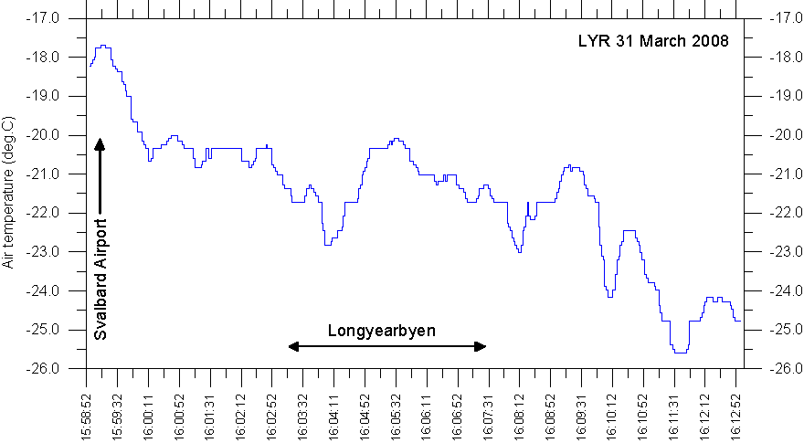
Result of temperature measurements along the route Svalbard Airport – Longyearbyen -Adventdalen, March 31, 2008. The official Svalbard meteorological station is located at the airport. Se map above for reference. Time (not corrected for summer time) is given in hh:min:ss format along the x-axis.

Interpretation of results

The whole area was snowcovered. The sun was below the skyline formed by the mountains, and albedo effects caused by buildings and roads for that reason presumably not very important.

The registered air temperatures show an overall falling trend towards SE along the main measurement route. Near the airport, where the official Svalbard meteorological station is located, air temperatures are relatively high (about -18oC), which is interpreted as the result of the onshore airflow from SE across the ice free fjord. Further towards SE, this local warming effect diminishes, and colder air (about -25oC) draining out of the valley Adventdalen dominates. The temperature difference between the Airport and Adventdalen is about 8oC, representing the open water effect (OWE) at this particular time. In between, the local heat island effect of the town Longyearbyen is only weakly developed. The maximum UHI effect appears to be about +0.5oC at the time of the experiment. The local cold trough recorded within Longyearbyen (16:04) corresponds to the position of the main valley axis, where cold air masses is draining NNE from the glacier at the valley head.

The existence of an urban heat island effect in a relatively small settlement as Longyearbyen may come as a surprise. This is, however, not the first time this has been observed in the Arctic; see, e.g., Hinkel et al. 2003.

=============================================

UPDATE2:

A commenter asked if satellite and surface data deviated here. Willis provides the answer.

I just looked at the MSU versus the NORDKLIM/GISS record, and the surface record shows much more warming than the satellite warming, almost twice as much. The surface record shows warming at 0.10 °C/decade, while the MSU record is warming at 0.06 °C/decade … here’s the graph:

w.

UPDATE3: From comments, we have a close up photo of the Stevenson Screen near the edge of the tarmac. Thanks to commenter “Oslo” for finding it at the Norwegian Metorological Institute website.

Stevenson Screen at Svalbard Lufthavn Airport

I wonder if the cinder blocks are a permanent feature?

UPDATE4

Erik Kempers writes in comments that he has found a Panaramio photo that was misplaced on the map that shows the weather station in perspective with the Svalbard airport runway and taxiway/tarmac. I’ve provided a zoomed and annotated version below. The original is here.

click to enlarge

5 1 vote
Article Rating
120 Comments
Oldest
Newest Most Voted
Inline Feedbacks
View all comments
May 13, 2010 12:14 am

Eureka is not alone!
Ecotretas

Phillip Bratby
May 13, 2010 12:19 am

Great follow-up to Willis’ article. Good detective work Anthony; I don’t know how you find the time to do all the work that Hansen, Schmidt et al should be doing with their taxpayer dollars!

May 13, 2010 12:21 am

A close look at the changes of the Geomagnetic field at Svalbard (and the nearby North Pole) may finally give us a clue what drives climate of the North Atlantic.
http://www.vukcevic.talktalk.net/LFC16.htm
http://www.vukcevic.talktalk.net/LFC-CETfiles.htm

Mindbuilder
May 13, 2010 12:23 am

Does the effect of this poor siting show up as a difference between the satellite and thermometer record?

Ibrahim
May 13, 2010 12:34 am
E.M.Smith
Editor
May 13, 2010 1:01 am

So we have whole degrees of “warming” from the AHI / UHI effects and are supposed to get excited about fractional degrees of overall ‘warming’ of the record?
When places like France and the USA are over 90% thermometers at airports in GHCN (and we know there were none at airports prior to 1914…)
Somehow I’m starting to think that AHI alone is sufficient to explain “global warming”…

Geir in Norway
May 13, 2010 1:04 am

On high time! Thanks so much! We Norwegians have recently been served this scary story about Svalbard warming up according to the latest “research”:
http://www.aftenposten.no/klima/article3646095.ece
(Aftenposten has recently won back its position as most sold newspaper in Norway.)
This is what they present as facts:
“Fact: This is the case NorACIA (Norwegian Arctic Climate Impact Assessment) today presents in a report on climate change and impacts in northern Norway, Svalbard and in the surrounding ocean.
The report is based on five studies in climate change issues, physical and biochemical systems, ecosystems and biodiversity, effects on people and society, and adaptation to climate change.
NorACIA have both used the facts from the IPCC and local data and scaled down global climate models to regional effects. ”
What they mean by facts from the IPCC I cannot fathom, but it seems they have been reading AR7 and the Svalbard dataset quite uncritically.

Henry Galt
May 13, 2010 1:13 am

The airport will be under several meters of catastrophic sea-level rise – about the same time as the area becomes hospitable. Such a shame. Think of the children. Run for the hills. Psst, wanna buy some cheap carbon credits?

Ralph
May 13, 2010 1:28 am

As a pilot, if you were waiting for an inbound aircraft to do an approach, landing and backtrack to vacate the runway, you could be holding next to that Stevenson Screen (engines running) for 10 minutes or so. Great plumes of hot exhaust playing over the screen for 10 minutes.
Might be more profitable to check the movement records for the airport, rather than the climatic records of the Arctic.
.

Editor
May 13, 2010 1:30 am

Mankind needs to worry much more about UHi than it does (possible) fractional warming caused by CO2.
The Romans recognised 2000 years ago that UHI made their 1 million population city unbearably hot and it caused beech trees to migrate to the hills and ice sellers to make a lucrative living.
When pontificating on global temperatures (which heaven knows is a highly debatable concept in the first place) we need to bear in mind two things;
Firstly that stations move and they are therfore not recording the original micro climate. By definition micro climates are different to one another so you may get different readings that could be exacerbated by local conditions-land use- or by climatic changes such as an alteration in the prevailing wind direction.
Secondly that there is a tendancy for stations to move to warm places such as airports-or if they don’t move of being engulfed by urbanisation.
The basic proposition of believing we have recent catastrophic global warming based on our extremely suspect temperature records is highly debatable. That we have a serious and much greater effect on our ‘local’ urban climate was something Emperor Nero knew about.
Tonyb

GK
May 13, 2010 1:43 am

The surfacestations scandal should have it`s own “gate” name like Surfacestationsgate.
The scale of the surfacestations scandal is so large, that it is impossible that the AGW peddlers dont know that the whole temp reconstruction is totally meaningless. I`m now 100% convinced that they they are fully away of how bad the data is, and they are just a part of the con to make a buck.
It`s inconcievable that anyone with anything more than pre-school maths knowledge doesnt comprehend the impact of this on the whole set of data

May 13, 2010 1:47 am

It’s an interesting UHI experiment, but it probably has to be repeated many times for confirmation. Some problems: The temperature fluctuates much along the route, so it is difficult to tell variations from topological differences from true UHI variations. The temperature at one spot also generally varies a quite a bit within an hour in this area. And the detour within the settlement is also slightly uphill, so a temperature rise can also be explained by inversion.
The UHI hypothesis sounds reasonable, though. Snow is white, buildings are dark. And during winter it’s common practice in Longyearbyen to let the car idle while parked outside the mall, etc, which will generate ever so slight heat.

May 13, 2010 1:49 am

“My bet is that we’ll see a local AHI (Airport Heat Island) at Svalbard. It’s a busy place. In 2009, the airport had 138,934 passengers.”
According to this site, there is generally one flight in, one out, per day.

freespeech
May 13, 2010 1:59 am

Perhaps all this alarmist talk of runaway greenhouse effects is just a simple spelling mistake? They seem to be actually talking about “runway” greenhouse effects.
Reply: Polite golf *clap* ~ ctm

phisher
May 13, 2010 2:08 am

Amazing…
This must be the best scientific site on the Internet, thanks for all your hard work.

nednead
May 13, 2010 2:18 am

Interesting, now you believe in the positive albedo effect. So it works over the tarmac but not over the sea ice? I wonder how that can be? How do you determine when it matters and when it doesn’t? Do you have surfaces you allow to have a positive feedback effect and those you do not? Strange indeed…

Editor
May 13, 2010 2:19 am

Great post, Anthony. I just looked at the MSU versus the NORDKLIM/GISS record, and the surface record shows much more warming than the satellite warming, almost twice as much. The surface record shows warming at 1.3 °C/decade, while the MSU record is warming at 0.8 °C/decade … here’s the graph:

[Edited to fix incorrect decadal averages, thanks to those who pointed it out]
w.

Signe Moerk
May 13, 2010 2:25 am

The Stevenson Screen you see on your picture has not been in use for a long time! It has a completely different location.
Best regards from mee, living in Longyearbyen

May 13, 2010 2:29 am

This description of re-surfacing work at Svalbard airport might be of interest…
http://www.voegele.info/en/aktuelles_und_presse/jobreports/Jobreports_-_Detailseite_123.html

Stig
May 13, 2010 2:32 am

I’ve been living in Longyearbyen, Svalbard for 8 years, from 1998-2006. No doubt, winters became warmer during that period. In winter 1997-98 the fjords froze all over, but they did not any of the next 8 winters. Glaziers at land melted substansially, and permafrost thawed. As a MSc student at the University in Longyearbyen ( UNIS) I drilled holes in the tundra and placed thermistors in the holes. They all showed that the active layer ( melting zone in the summer) went deeper year by year.
This is of course not so interesting as the time span is too short, but it supports the general opinion that the Arctic has become warmer during the last decades.
The question, however, is if this increase in temperature in the Arctic, is due to natural variations or burning fossil fuel. What we know for sure is that all avaliable history and measurements from Svalbard tells us that the 1930-40’s were just as warm as today, glaciers melted, less fjordice and probably also melting tundra…
Too sad it’s not accepted to ask these kind of questions anymore. So keep up the good work Anthony!

Steveta_uk
May 13, 2010 2:39 am

Pity we don’t have a static temp measurement for comparison – sun was “below the skyline” but he doesn’t say for how long, and without a return-trip, there’s no way of knowing how much of the temperature drop was simply an early evening decline.

Ibrahim
May 13, 2010 2:45 am
May 13, 2010 2:47 am

Some might find this article interesting: “Temperature variations at Svalbard during the last century”, for general background.
http://www.nordicspace.net/PDF/NSA106.pdf
But as for the AHI effect, let’s see what happened in 2006.
Passenger numbers increased from 2005 to 2006 by 34.5%, and total aircraft movements of around 7.6%.
In 2006 the runway was re-surfaced (note: parts were formerly white to reduce melting of permafrost beneath, but now all black), the safety zones were enlarged and the terminal was being upgraded, so there was all that extra construction etc as well. The runway and taxiway is now 170,000 sq.m of asphalt.
Then we read in the WMO’s “Annual Bulletin on the Climate in WMO Region VI – Europe and Middle East – 2006”
“On Svalbard it was more than 12 °C warmer than normal in January and again in April 2006, and more than 5 °C on the annual average.”
Oh, what a surprise!

May 13, 2010 2:52 am

Another interesting paper on the airport. Demonstrates the effect climate models have on real world engineering assessments.
Title reads “Svalbard airport runway. Performance during a climate-warming scenario.”
http://www.ivt.ntnu.no/bat/vs/bcra/workshops/workshop1/W1_2%20Instanes_BCRA2005BCRA05paper00241.PDF

ditmar
May 13, 2010 2:53 am

Re Nick Stokes
I’m sure you’re right, generally one flight in and out per day. However I am also sure that the raw materials, equipment,facilities, and construction workers required to upgrade the airport were not locally sourced. Also the mining equipment,materials, facilities, transport,constuction workers, utility suppliers and corresponding infrastructure, including the generator needed were all flown in on that pristine tarmac to constuct the GLOBAL SEED BANK! I think that alone will remove the anomalous apr. 2006 temp. I’m sure you will concede that, or will you?

mike
May 13, 2010 3:04 am

but when were the thermometer and tarmac placed respectively?

Jimbo
May 13, 2010 3:07 am

E.M.Smith says:
So we have whole degrees of “warming” from the AHI / UHI effects and are supposed to get excited about fractional degrees of overall ‘warming’ of the record?

Totally agreed. Also warmists tell us that it’s the trend that matters and don’t realise that there is a trend for increased international air travel, airport expansion and urban creep.
freespeech – you are spot on. This is truly runway Mann-made global warming from weather thermometers.

Editor
May 13, 2010 3:13 am

nednead says:
May 13, 2010 at 2:18 am

Interesting, now you believe in the positive albedo effect. So it works over the tarmac but not over the sea ice? I wonder how that can be? How do you determine when it matters and when it doesn’t? Do you have surfaces you allow to have a positive feedback effect and those you do not? Strange indeed…

nednead, I’m not sure who the “you” is in “now you believe in the positive albedo effect.” Let me renew a call that I have made many times. If you disagree with something that someone has said, cite it and quote it.
Otherwise, you may have a valid point, but since no one has a clue who you are talking to or what you are talking about, your comment will get ignored.

Editor
May 13, 2010 3:16 am

Signe Moerk says:
May 13, 2010 at 2:25 am (Edit)

The Stevenson Screen you see on your picture has not been in use for a long time! It has a completely different location.
Best regards from me, living in Longyearbyen

Man, I hates it when someone does that …
Signe, if you know where it is, how about you come down off of the mountain of pure knowledge and tell us where it is? Post a google earth view of it, send us a sketch, show us a photograph, use naval signal flags, I don’t care how, but hey, give us a clue as to its real location .

Editor
May 13, 2010 3:19 am

Stig says:
May 13, 2010 at 2:32 am (Edit)

I’ve been living in Longyearbyen, Svalbard for 8 years, from 1998-2006. No doubt, winters became warmer during that period. In winter 1997-98 the fjords froze all over, but they did not any of the next 8 winters. Glaziers at land melted substansially, and permafrost thawed. As a MSc student at the University in Longyearbyen ( UNIS) I drilled holes in the tundra and placed thermistors in the holes. They all showed that the active layer ( melting zone in the summer) went deeper year by year.
This is of course not so interesting as the time span is too short, but it supports the general opinion that the Arctic has become warmer during the last decades.
The question, however, is if this increase in temperature in the Arctic, is due to natural variations or burning fossil fuel. What we know for sure is that all avaliable history and measurements from Svalbard tells us that the 1930-40′s were just as warm as today, glaciers melted, less fjordice and probably also melting tundra…
Too sad it’s not accepted to ask these kind of questions anymore. So keep up the good work Anthony!

Thanks, Stig. In my thread here, there’s a great citation to a page in Norwegian discussing the effect of wind on the temperature of Svalbard. I also show a graph that shows that temperatures have cooled since 2006 …

Capn Jack
May 13, 2010 3:19 am

What a shameless plug in an article,
when my great fleet of Pirates turned Privateers were gonna turn the world into an Eden.
We need fleets of Pirates turned savior with rotating masts and big bilge pumps.
Yeah right, thermometers and Stevenson screens in the right place is gonna save the planet.
Got a good miind to report Watts to the advertising board on subliminal advertising nd not so sublimal advertising.
Me mate Nemo designed them silver lining ships , Me and Nemo discovered Svaldie boo boo port and we done it in winter.

kwik
May 13, 2010 3:35 am

Well, I cannot understand why it is so difficult.
Look here;
http://www.yr.no/place/Norway/Svalbard/
So there is 5 stations. Click English upper right corner.
Click for example Hopen.
http://www.yr.no/place/Norway/Svalbard/Hopen/
Click Statistics;
http://www.yr.no/place/Norway/Svalbard/Hopen/statistics.html
For more statistics, go here;
http://sharki.oslo.dnmi.no/portal/page?_pageid=73,39035,73_39049&_dad=portal&_schema=PORTAL&6009_BATCHORDER_3197941
Click English.Get your username and password, and you can get data for these stations
REPLY: The URL for the English page: http://met.no/English/
…gives me a spartan, nearly useless presentation. There’s no data I can see there, most links are gone.
Met.NO English page

Pascvaks
May 13, 2010 3:44 am
May 13, 2010 3:57 am

OT, but I can’t get the “tips and notes” to work.
Just to say have a good conference in Chicago, Anthony.
I’d love to be there but the sailboat racing series comes first.

imapopulistnow
May 13, 2010 4:08 am

Real Scientists would be extremely grateful for your discoveries because they help further the accuracy of the data base by identifying outliers.
Real Climate Scientists on the other hand……

Capn Jack
May 13, 2010 4:22 am

Skaal.

Ralph
May 13, 2010 5:24 am

>>ScientistForTruth says: May 13, 2010 at 2:47 am
>>In 2006 the runway was re-surfaced
Anyone who has seen re-tarmacing will know how energy intensive it is.
Now let me guess: They cannot retarmac the apron in the winter, but they would want to get it done before the tourist season.
So. How about APRIL??
.

Geoff Sherrington
May 13, 2010 5:33 am

Please can someone do this simple exercise.
Take an airport of known area. Find the number of aircraft movements per year. Assume a weight for each aircraft, take-off and landing. Estimate the energy required to lift then lower the total weight of those aircraft to say 500 ft. Convert the energy into watts per sq m and then into temperature change. With the many pages of talk on airports, I have failed to find if the fuel burning alone is in the right ball park to raise temperature. (This is separate from jet wash problems and albedo changes).

geo
May 13, 2010 5:40 am

Nice job. Perhaps this “ends of the earth” series ought to be pursued to completion? It is certainly off to a very interesting start, and it seems clear that the topic merits that pursuit given the overweighted importance these stations have in the record, and in the general AGW theory of outsized impacts on the Arctic/Antarctic.
I’m off to look at five stations in northern Iowa (Le Mars, Storm Lake, Rockwell City, Iowa Falls, and Fayette) this weekend. From the satellite data I’m not expecting anything this exciting, however!

LearDog
May 13, 2010 5:42 am

Wow. This is an AMAZING post and set of comments. You guys are fantastic !
Thanks for everyone’s engagement.

Oslo
May 13, 2010 5:46 am

Here are the figures for Svalbard Airport, as reported by the Norwegian National Weather Service. The top graph is for April, the middle is for winter, and the bottom graph is yearly anomalies:
http://www.yr.no/klima/bakgrunn/1.6266962
More information about the measuring station form the same web page:
The measuring station is now situated at Svalbard airport. before 1974, the data comes from other measuring stations on Spitsbergen (Svalbards main island), but the data have been adjusted to also account for Svalbard Airport. (could make an interesting study).
And there is a photo of the station, probably taken from the runway:
http://met.no/filestore/svalbard_lufthavn2.jpg
In 2006, the runway was made 160 meters longer and 3 meters wider on each side. From the construction company’s own measurements, the temperature of the runway surface ranges from -44 degrees celsius to +22 degrees celsius (!). A new terminal building was begun constructed the same year, and was operational in 2007.
In 1989, construction was undertaken to insulate the runway surface from the permafrost in the ground. As the permafrost beneath the surface has melted, due to the surface temperature of the runway, the runway became bumpy. This project was deemed “partly successful”.
My guess is that insulating the runway surface from the cold permafrost below, would tend to increase the surface temperature, as the cooling effect of the cold permafrost would diminish. This effect could be significant, as the difference between a surface temperature of up to 22 degrees in summer and the permafrost (around 0 degrees) is quite large. Insulation would make the surface temperature higher, and would make it cool off much slower in evenings as sunlight fades.

Captain Cosmic
May 13, 2010 5:49 am

If you search the various METARs databases for Svalbard (ICAO code ENSB) the coordinates given suggest that the weather station is about half a mile to the NW of the airport. 78 15 01N 15 28 01E. This seems a bit of a strange thing to do though – pilots want to know the weather on the runway not the weather half a mile away! So it may be some sort of typo.
Don’t know if that helps any.

Pamela Gray
May 13, 2010 6:08 am

This airport heat island affect, and the lesser urban bump through town, may show topography effects (the airport is in a shallow canyon that would encourage warmer inland airflow towards the sea versus sea breezes onto land), AND urban heat island effects. Local topography can produce major local affects: well defined pockets of cold and warmth in an around urban areas that will show up even on the most idyllic setting for a temperature gauge. It isn’t always about urban heat from humans. It could be the lay of the land as well. That might be the case here. Regardless, the outcome is the same. A temperature gauge might be picking up topography effects (which will be influenced by weather pattern oscillations) as well as human influences at the local level that will then be mistakenly -or not- gridded to represent an entire region.

Pamela Gray
May 13, 2010 6:14 am

To expand on topography, when the northern Pacific is cold, the topography of the coastal areas will demonstrate changes in warm and cool breezes (and pockets of temperature differences) that stick around till the ocean warms up again. When it does, these same pockets of warm and cool breezes will change with this oscillation. Temperature gauges located in urban heat islands may not be so sensitive. They just keep getting warmer from baseline (one story wooden structure, no parking lot) to completed construction (surrounded by asphalt next to a tall brick building).

May 13, 2010 6:25 am

nednead says:
May 13, 2010 at 2:18 am

Interesting, now you believe in the positive albedo effect. So it works over the tarmac but not over the sea ice? I wonder how that can be? How do you determine when it matters and when it doesn’t? Do you have surfaces you allow to have a positive feedback effect and those you do not? Strange indeed…

Water gets very reflective at low angles of incidence, such as the Arctic circle. That is why you get significant glare off the sea at sunrise and sunset everywhere.
Tarmac, on the other hand, does not. The most glare to be seen on tarmac seems to be in the middle of the day in my experience. I am not sure how the physics of that works, however, but it certainly absorbs heat, even at low angles of incidence.
So the answer to your question is ‘observation’, as opposed to the speculation which seems to be very much in vogue among those pushing the ever-floundering Hidden Global Warming hypothesis (if it can even be dignified with such a label).

Theo Goodwin
May 13, 2010 6:25 am

Anthony writes:
“Maybe somebody can convince them to get off their taxpayer funded butts and away from their computer screens someday and do some field work.”
God Bless Anthony. Hansen and friends are Cartesians. They lie abed until noon daily and meditate on their deductive schemes.

May 13, 2010 6:38 am

Climate isn’t the only place where our past is constantly changing.

Erik
May 13, 2010 7:09 am

@Geir in Norway says:
May 13, 2010 at 1:04 am
On high time! Thanks so much! We Norwegians have recently been served this scary story about Svalbard warming up according to the latest “research”:
http://www.aftenposten.no/klima/article3646095.ece
—————————————————————————————-
Just mailed the Author Mr. OLE MAGNUS RAPP the two WUWT links

tommy
May 13, 2010 7:13 am

And this same island had palm trees and tropical animals a few millions years ago even though it was located at around same latitude as today..

Dave McK
May 13, 2010 7:24 am

That station is absent from the published data files here:
http://data.smhi.se/met/climate/time_series/day/temperature/
I looked at those ones and there are a lot of airports- but- in the data those airports, even in the middle between runways- they track the other stations very well.
I think it’s because the land is so flat and must have a mostly smooth laminar flow of wind from down the mountains. You can watch seas of cold air move across the region in an animated series.
I’d suggest that wind direction could blow warm air off the tarmac on occasion, but it didn’t show up in any remarkable way in the data I examined. Thus, intermittently spoofed data might be the normal presentation, rather than a reliably consistent effect.

Ed Caryl
May 13, 2010 7:25 am

Another nail in the AGW coffin. Mann and Jones should both retire to somewhere warm. Can I suggest Svalbard?

Enneagram
May 13, 2010 7:30 am

Hey buddies!, wanna know something?. It is NOT about temperatures, who cares about them!, it´s about me and my friends to rule over you…
You just work!

David Corcoran
May 13, 2010 7:34 am

“People like Jim Hansen and Gavin Schmidt who sit up at the top of the climate food chain and take data from these weather stations at face value”…
I’m sure that they know the data’s garbage, but it serves the narrative. They’re in the advocacy biz, which yields much more power and money than science.

Mike Roddy
May 13, 2010 7:42 am

You really need to give up this weather station stuff. Remember what happened last time? Do you want more of that kind of punishment?
REPLY: Oh Mike, shut your pie hole. You and your team of dhoghaza clones will abuse me anyway. Look at the sat/surface comparison. Just wait till my paper comes out. -A

May 13, 2010 8:04 am

Any damn windmills on that island too?
Look what they’re doing to Norway’s coastline. This clip is in Norwegian, but the pictures tell the story. http://www1.nrk.no/nett-tv/klipp/282395
You can read some about this at yours truly. Maybe Piehole Mike ought to think about it.

May 13, 2010 8:24 am

Cassanders had a very illuminating contribution to Willis’ thread, about the West Spitsbergen Current:
Cassanders says:
May 13, 2010 at 12:17 am
More on the WSC, a major point along the Atlantic heat exchange corridor here:
http://oceancurrents.rsmas.miami.edu/atlantic/spitsbergen.html
A link on this site takes one to graphs showing seasonal effects of the currrent.

May 13, 2010 8:30 am

Clearly Hansen’s GISS temp data are worthless. What a waste of money.
Thanks for informing us where all the warming up north is coming from.

tarpon
May 13, 2010 8:35 am

Just imagine if the data here were actually being done by those who are paid to do it.
Oh wait, then the lies would be exposed. Never mind.

Tim Clark
May 13, 2010 8:38 am

I found another tourist photo on Panaramio, that shows the characteristic metal legs and struts of the Stevenson Screen visible beyond the plane that tourists are boarding:
A mark of true devotion to a cause is becoming more interested in the strutting of metal legs as opposed to the human kind. ;~D

Ralph
May 13, 2010 8:42 am

>>Take an airport of known area. Find the number of aircraft
>>movements per year. Assume a weight for each aircraft, take-off
>>and landing.
A 737 will burn about 200 kg taxying, and about 200 kg on the take off run (diesel fuel).
Multiply by 5 or 6 for a 747.
.

May 13, 2010 8:44 am
May 13, 2010 8:51 am

Well with all the additional info and pictures being submitted in the comments, I look forward to part three, as the screen appears to have moved several times and the airport has also expanded.
Is there anything to suggest that the data from this airport has been tinkered with, I mean filtered, by GISS etc?

Henry chance
May 13, 2010 8:55 am

Mike Roddy says:
May 13, 2010 at 7:42 am
You really need to give up this weather station stuff. Remember what happened last time? Do you want more of that kind of punishment?

Looks like the global warming puppy mill is busy. I am exited about the warming. More CO2 and more warming means they can raise local fruits and veggies.
Too bad they have their “pretend science” reduced to one variable and that is CO2. No honest scientist would ignore air and water currents as factors for warming on this island.

maz2
May 13, 2010 9:06 am

Al Gore’s Weather (AGW) : Ash Report has now invaded Muslim Land.
AlGW concurs: “”We do our best to make reliable predictions. We do not pretend to be psychics,”.
Forwarded to BanUN/IPCC.
…-
“Europe’s travelers ponder a summer turning to ash
By SHAWN POGATCHNIK (AP) – 5 hours ago
DUBLIN — It’s been a month now, and Iceland’s volcano shows no sign it will stop belching ash across Europe anytime soon. A whole continent is rethinking its summer vacation plans — and struggling airlines are wondering how to cope in the cloud of uncertainty.
Although the global disruption of last month’s massive eruption has faded, smaller ash plumes snarled air services intermittently over the last week all the way to Turkey — more than 2,500 miles (4,100 kilometers) from the Eyjafjallajokul (pronounced ay-yah-FYAH-lah-yer-kuhl) volcano.
Air-control authorities and geologists agree that the continent must be braced indefinitely for rapid shutdowns of air services as computerized projections try to pinpoint where the ash clouds will float next at the whim of shifting winds.
“We do our best to make reliable predictions. We do not pretend to be psychics,” said Einar Kjartansson, a geophysicist at the Icelandic Meteorological Office, who often has been asked to guess the volcano’s next move since it began spitting lava and ash March 20.”
http://www.google.com/hostednews/ap/article/ALeqM5iUxHXkUVC1z6ZW2zVsbcafyZxivAD9FLTC680

Steven mosher
May 13, 2010 9:18 am

Geoff Sherrington says:
May 13, 2010 at 5:33 am
Please can someone do this simple exercise.
“Take an airport of known area. Find the number of aircraft movements per year. Assume a weight for each aircraft, take-off and landing. Estimate the energy required to lift then lower the total weight of those aircraft to say 500 ft. Convert the energy into watts per sq m and then into temperature change. With the many pages of talk on airports, I have failed to find if the fuel burning alone is in the right ball park to raise temperature. (This is separate from jet wash problems and albedo changes).”
The problem is more difficult than this. Recall that the temperature is reported as
a Min/Max. I’ll, just make it simple to show the problem. 24 numbers starting at midnight. These are made up just to show the problem
0 1 2 3 4 5 6 7 8 9 10 12 11.6 11.5 11 10 9 8 7 5 3 2 1
Ok. so if you read at midnight you get a Min of ZERO and a Max of 12.
To “infect the record” you dont just need to add heat. you need to add the right amount of heat at the right time. If every plane landed at 2AM when its 2C.
Then the only number you can infect is TMAX. if the wind is blowing ( no tall building to obstruct flows ) then you’ll probably not be able to infect TMAX.
but it all depends…
Land all the planes at the heat of the day? different problem obviously. land them
all right before the cold point. again different problem. If you land everything right after the heat of the day, same kind of difficult problem. land them sporatically during the day.. different problem altogether.
Its one of the benefits of sampling the high and the low only.
The UHI impacts that would appear to have the highest probability of infecting the record are those that are persistent. Like, a change to the landscape, either in materials or things like building height. Transients, like warming from artificial sources, while important to eliminate, are much harder to assess.
Since it is an airport there should be hourly reports. wind direction as well.
FWIW, NOAA did a study of the difference between an airport and a CRN.
effect size was less than .25C. modulated by winds and clouds.
So, while we need to recognize the importance of the change in albedo we ALSO have to recognize that clouds change the impact of that impact, as does wind. This isnt a simple matter of lining up all the heat biases without considering the mitigating factors. Both need to be considered.
There is also good reason to believe that the airport effect may be less than the UHI effect precisely because of the construction limitations. One of the principle drivers in UHI is building height. Buildings that create radiataive canyons, limit skyview, and disrupt the boundary layer. The correlation between building height and UHI is quite dramatic. waste heat? dunno, not much I’ve read on that. Again, the role of waste heat would seem to be highly situational

AnonyMoose
May 13, 2010 9:19 am

Fortunately this is a small enough airport that they’re not using jetways (boarding tunnels), so people have the opportunity to take photos outside.

May 13, 2010 9:31 am

The mid-day tarmac glare mentioned above, unlike the glare off the late-in-the-day sea, should be due to a local temperature inversion refractive border, like a mirage in the desert—hot air next to the sun-warmed tarmac, cooler ambient air just above.
KW

stevia
May 13, 2010 9:35 am

Nick Stokes at 1.49am 13/10
That makes an average of 3,858 people per flight. Did the numbers come from Penn State?

bubbagyro
May 13, 2010 9:47 am

The trip from the airport to the city showed a differential of about 8°C. I’m sure the trip could not take long enough for the temperature to change due to solarization changes. But if there is a difference that great in that short a distance, then the Stevenson station, no matter where it is, is not representative of the island. But, let’s give the conservative approach that the airport is AHI affected, and halve the amount to say, 4°C. What happens if we subtract 4° from every airport station on the globe starting with year 2000? Call it a straightforward correction, as climate scientists are wont to do. What does the global temperature look like then?

ML
May 13, 2010 10:00 am

stevia says:
May 13, 2010 at 9:35 am
Nick Stokes at 1.49am 13/10
That makes an average of 3,858 people per flight. Did the numbers come from Penn State?
******************
If you apply a homogenisation and a “fudge factor” the number, 3,858 people per flight, sounds about right :~)

Enneagram
May 13, 2010 10:01 am

vukcevic says:
May 13, 2010 at 12:21 am

See?, everyone is afraid of getting near to causes. You are closer to the root of it. One more step it would mean to ask ourselves what powers all these phenomena. No one will dare to answer, though the most repeated “meteor” on earth is lightning (about 30 million a day, if I am not wrong):
http://www.thunderbolts.info/tpod/2006/arch06/060322sprite.htm

May 13, 2010 10:01 am

Apparently there are more polar bears on Svalbaard than humans and the humans are permitted to carry guns for protection against these beastly predators.
See question number 20 on this FAQs about Svalbard: “Do I have to have a gun license when arriving Svalbard..?” http://www.svalbard.com/SvalbardFAQ.html#gun%20license
What a refreshingly healthy attitude to wildlife!

May 13, 2010 10:15 am

Some random thoughts, having read the entire thread (wot a concept!):
(1) The elevation shown for the station is 95 feet, yet it’s located near the fjord. Based on that, I began to wonder whether the Stevenson screen instrument is still in use or has been replaced with a sensor mounted atop the control tower. (But why wouldn’t they tear the old one down immediately? One less thing to run a jet into.) (2) If the heat island profile is that variable because of local microclimate, then it would seem that an unusually persistent “wind snap” towards the fjord for a week or two could easily create a large apparent monthly anomaly. (3) Asphalt machines have huge (12′ x 8′) banks of fired heaters that soften asphalt to the melting point. Using one of those anywhere near the sensor for a week or two could easily give high readings. Has anyone looked at the day-to-day data? (4) In my P.Chem. days we were told to toss out any 3-sigma outliers as obviously erroneous. Hansen et Al [sic] are trying to tease a 0.1°C/decade signal out of the data. An alleged 5-sigma monthly outlier clearly doesn’t contain such a signal in any recoverable way. They have all gone mad. [See “Messiah Complex”.]

Ibrahim
May 13, 2010 10:17 am

Temps for Svalbard airport from 1910
http://www.yr.no/klima/bakgrunn/1.6266962
( http://www.yr.no/klima/ )

May 13, 2010 10:23 am


stevia says:
May 13, 2010 at 9:35 am
Nick Stokes at 1.49am 13/10
That makes an average of 3,858 people per flight. Did the numbers come from Penn State?

“Daily flights from Oslo” doesn’t necessarily mean one per day, but at least one. Besides, not all flights start in Oslo, and there are flights between the settlements in Svalbard as well. Svalbard airport is an extremely busy airport for an archipelago with a few thousand inhabitants. Partly thanks to the AGW hype.

Rod Smith
May 13, 2010 10:38 am

Well, I’ll submit my admittedly apocryphal comments about tarmac temperatures.
I spent 9 years in the USAF as an aircrew member, and as a result spent much more time on tarmacs that one would suspect. My casual observation is that flight line are much colder in winter and much warmer in summer than even just a couple of hundred feet off the edges. They are also much windier. They are generally very miserable places (weatherwise) to work.
Having said that, I am compelled to state that, in my opinion, the use of surface temperatures alone are probably the least accurate way to describe/forecast weather or climate (extended weather), and adding estimated CO2 just muddies the picture. What about moisture, precip, wind (monsoons, or foehn winds), clouds, permanent pressure systems (Shemya or Bermuda), and more?
I would guess the average temperature where I live was about the mid-to-lower seventies for the last 30 days. Would even a more accurate value adequately describe the climate?

May 13, 2010 10:56 am

pgosselin says:
May 13, 2010 at 8:04 am
Any damn windmills on that island too?
Look what they’re doing to Norway’s coastline. This clip is in Norwegian, but the pictures tell the story. http://www1.nrk.no/nett-tv/klipp/282395

That is a different island, Smøla, much further south. They discuss the problems caused by the wind turbines for the local eagles. One eagle is shown cut in two. Actually a rather critical program, not often seen around here.

Daniel H
May 13, 2010 12:11 pm

You can also view the Svalbard Longyearbyen Airport weather station in this youtube video at about the 9:05 mark. Right as the plane is landing, you’ll notice the Stevenson Screen zoom past the window quite clearly!

If you prefer to view it during takeoff (as opposed to landing), then see if you can spot the Stevenson Screen zoom past at about the 18 second mark in this video:

May 13, 2010 12:16 pm

stevia says: May 13, 2010 at 9:35 am
That makes an average of 3,858 people per flight. Did the numbers come from Penn State?

Huh? 138934/365/2=190.32

1-26er
May 13, 2010 1:07 pm

The example temperature profile in this post (airport then inland) has an important confound factor in assessing the airport pavement affect. The wind arrows show the air reaching the airport has a fetch over the unfrozen fiord. The temperature delta between air and water is at least +20 C. It is difficult to estimate how a short fetch and large temperature delta would change the airport temperature but it is certain the change would be positive. This location is a complex one because of the interaction of terrain, marine air and local glaciers.

stevia
May 13, 2010 1:11 pm

Hi Nick at 12.16pm.
I assumed 360 days and that a passenger was only counted once and then slipped the decimal by one place. The speed of the fingers exceeding the neuron connection rate.

Gail Combs
May 13, 2010 1:39 pm

Ibrahim says:
May 13, 2010 at 12:34 am
UHI was measured:
http://climate4you.com/LongyearbyenUHI%2020080331.htm
________________________________________________________________________
If you are the same person who did the UHI measurement, Thank you. And of course a very big thank you to Anthony and Willis who just keep coming up with more and more information. My hat off to all three of you.

Anders L.
May 13, 2010 2:02 pm

ScientistForTruth
“On Svalbard it was more than 12 °C warmer than normal in January” (2006)
Yes, of course the famous Svalbard January sunshine had something to do with that…

tty
May 13, 2010 2:05 pm

The speculation about aircraft holding, waiting for inbound flights etc at Svalbard airport are unrealistic. Essentially there is one (1) B-737 or MD-90 flight from Tromsö per day, plus a few short-haul flights (Do 228’s I think) to Sveagruvan and Ny Ålesund.

Barry Kearns
May 13, 2010 2:23 pm

stevia says:
May 13, 2010 at 9:35 am
Nick Stokes at 1.49am 13/10
That makes an average of 3,858 people per flight. Did the numbers come from Penn State?

Could you show your work? When I do the following:
138934 / (365 * 2) = 190.32
I get about 191 passengers per flight. How did you come up with over 20 times as much?

Gail Combs
May 13, 2010 2:30 pm

Signe Moerk says:
May 13, 2010 at 2:25 am
“The Stevenson Screen you see on your picture has not been in use for a long time! It has a completely different location.
Best regards from mee, living in Longyearbyen”

______________________________________________________________________
Where is it? How about pictures, map? When was it moved? The more information the better.

Editor
May 13, 2010 2:34 pm

Is there anyone really surprised that Signe Moerk May 13, 2010 at 2:25 am
who claims to be “living in Longyearbyen” has thus far declined to respond to Willis Eschenbach May 13, 2010 at 3:16 am to substantiate the claim that the pictured Stevenson Screen is not the temperature recorder at Svalbard? Just another veristically and intellectually challenged drive-by

Gail Combs
May 13, 2010 2:55 pm

nednead says:
May 13, 2010 at 2:18 am
“Interesting, now you believe in the positive albedo effect. So it works over the tarmac but not over the sea ice? I wonder how that can be? How do you determine when it matters and when it doesn’t? Do you have surfaces you allow to have a positive feedback effect and those you do not? Strange indeed…”
_______________________________________________________________________
SIGHhhh Are you really that ignorant?
There is a heck of a lot of difference between the albedo effect of snow, ice and water (at the poles) and the albedo effect of black tarmac. Try stripping in the winter and changing clothes. You will learn real quick it is better to stand in bare feet on nice warm black tarmac than to have your feet stick to the !@#@ ICE! And yes I have done it many times. I cave in the winter in wet systems and have had to cut my frozen boots laces off more often than I like to admit. (OK so I am a little weird)
Surface Typical albedo
Fresh asphalt…….0.04[1]
Worn asphalt………….. 0.12[1]
Conifer forest
(Summer)………………. 0.08,[2] 0.09 to 0.15[3]
Deciduous trees………. 0.15 to 0.18[3]
Bare soil…………………..0.17[4]
Green grass……………..0.25[4]
Desert sand……………..0.40[5]
New concrete………….0.55[4]
Ocean Ice………………..0.5–0.7[4]
Fresh snow……………..0.80–0.90[4]
Water is a completely different beast and the angle of incidence of the light changes its albedo big time. (If you sail you will get a really bad sunburn in an hour or two even if you have never burn on land. And yes I have done that too…. once)
” Water reflects light very differently from typical terrestrial materials. The reflectivity of a water surface is calculated using the Fresnel equations …
Although the reflectivity of water is very low at low and medium angles of incident light, it increases tremendously at high angles of incident light such as occur on the illuminated side of the Earth near the terminator (early morning, late afternoon and near the poles)… http://www.answers.com/topic/albedo
Fresnel equations graph: http://en.wikipedia.org/wiki/File:Water_reflectivity.jpg

May 13, 2010 3:08 pm

Gail Combs,
Oslo posted this close-up picture above. The station is not on asphalt.
REPLY: I never posted that it was “on the asphalt” just next to the tarmac. – A

Qrious
May 13, 2010 3:12 pm

To Nick Stokes
Well, first, the page you linked says there are daily flights from Oslo and possibly also daily flights from Tromso. But, you linked a Norweigan travel page which gives you the sites in Norway from which planes go to Longyerbyen. Is it possible there are also connections from Sweden, Russia, the Netherlands, perhaps even so far away as the UK ? I’ve heard they got bigger gas tanks on planes these days

DaveH
May 13, 2010 3:19 pm

This is very interesting as it brings into question the validity of the anomaly reported by GISS for the Arctic. GISS fills in temperatures for the grid cells that have no ground measurement stations by interpolation from ground stations up to 1200 km away. In the case of the high latitudes in the Arctic there are very few current stations indeed (only three or four )… and Svalbard Luft is one of these. If Svalbard Luft is affected by AHI, then the anomaly reported by GISS for half of the arctic is also in error.

Gail Combs
May 13, 2010 3:23 pm

marchesarosa says:
May 13, 2010 at 10:01 am
Apparently there are more polar bears on Svalbaard than humans and the humans are permitted to carry guns for protection against these beastly predators.
See question number 20 on this FAQs about Svalbard: “Do I have to have a gun license when arriving Svalbard..?” http://www.svalbard.com/SvalbardFAQ.html#gun%20license
What a refreshingly healthy attitude to wildlife!
________________________________________________________________________
What a great place to send the Congress critters who are trying to ban guns in the USA. An all expense paid one month tenting vacation with out guns of course where lots of fish and meat is served alfresco.

Ibrahim
May 13, 2010 3:32 pm

There are more stations in the Arctic ; historical temperatures from Danmark and Greenland:
http://www.dmi.dk/dmi/index/klima/klimaet_indtil_nu/temperaturen_i_groenland.htm
And there’s always Eureka.

May 13, 2010 3:35 pm

Qrious,
Nope. Note the last Q&A here.
“Only one country, Norway, is reachable from Longyearbyen, Svalbard. with 100% of the airport destinations. “
The flight schedule from the airport is here. Basically one flight per day, to Oslo via Tromso. Sometimes 2 flights in high summer, and, from the look of it there, no flights for much of winter.
And Anthony, in my remark on asphalt I was responding to Gail Combs, who wrote a whole lot about asphalt albedo.

Gail Combs
May 13, 2010 3:56 pm

Nick Stokes says:
May 13, 2010 at 3:08 pm
Gail Combs,
Oslo posted this close-up picture above. The station is not on asphalt.
REPLY: I never posted that it was “on the asphalt” just next to the tarmac. – A
_________________________________________________________________________
It looks like the same Stevenson Screen. If you look at the background in the panorama image, it seems to match the background in the photo of the Stevenson Screen but at a slightly different angle. If it is the same screen the photo is taken from the runway.

DaveH
May 13, 2010 4:02 pm

Ibrahim says:
May 13, 2010 at 3:32 pm
“There are more stations in the Arctic ; historical temperatures from Danmark and Greenland:”
Indeed there are more stations, but I was talking only about the stations used by GISS for their temperature and anomaly calculations. The list of stations is here…
http://data.giss.nasa.gov/gistemp/station_data/station_list.txt
Anomalies close to the pole are calculated from just these few stations…
Number Name Dist from N Pole (km)
43120000 NORD ADS 932.4
200460003 GMO IM.E.T. 1043.4
719170006 EUREKA,N.W.T. 1110
200690003 OSTROV VIZE 1165.5
10080002 SVALBARD LUFT 1298.7

David Alan Evans
May 13, 2010 4:47 pm

I’ve mentioned before that I’m ex-R.A.F..
Here’s how we cleared runways, peri-tracks etc.
1) a sicard (combination of plough & Archimedes screw) would clear the bulk of the snow.
2) Then, send in the ice clearing, 2 jet engines with diffusers to spread the outlet & melt the remaining snow, also drying the surface to prevent re-freeze.
Wonder if commercial airports use similar methods.
DaveE.

John Finn
May 13, 2010 5:53 pm

Willis Eschenbach says:
May 13, 2010 at 2:19 am
Great post, Anthony. I just looked at the MSU versus the NORDKLIM/GISS record, and the surface record shows much more warming than the satellite warming, almost twice as much. The surface record shows warming at 0.10 °C/decade, while the MSU record is warming at 0.06 °C/decade … here’s the graph

Willis
The difference in trends looks to be an artifact of the greater variability of the surface record. In particular the dip in the late 1980s (near the start of the record) and the spike in 2006 (near the end) seem to be responsible. There is no long term divergence. The orange and blue line track each other closely between 1983-1986, 1994-1998 and they’ve come together again in the last couple of years.
I am suspicious of the April 2006 anomaly, though. “Nearby” stations such as Danmarkshavn exhibit generally warmer anomalies in 2005 and 2006 but nothing like the Svalbard. I don’t suppose the April 2006 anomaly could have originally been a missing value or something similar. The fact that it happens to be exactly 0.0 and an outlier makes it look a bit suspect.

Erik Kempers
May 13, 2010 5:54 pm

A proper image of the weather station (http://www.panoramio.com/photo/23883022) can be found by clicking on the panoramio link in Google Earth just south of the western threshold of the runway. (Photo location is not correct)
There are probably two wind masts at location 781500N 152520E and 781442N 153023E (deg/min/sec). In GE there is a faint line shadow visible at these locations. There should also be a transmissometer to report Runway Visual Range but I cannot find its location.
The location of the screen should be as close to runway as possible with ICAO standards as guideline. Be reminded that the main function of these weather stations is to report runway weather conditions in order to enhance flight safety. They have not been set up as climate stations.
REPLY: The transmissometer is visible in the zoomed image I’ve added to the main body of the post. Thanks for finding this. – Anthony

David Alan Evans
May 13, 2010 6:10 pm

Rod Smith says:
May 13, 2010 at 10:38 am

Well, I’ll submit my admittedly apocryphal comments about tarmac temperatures.
I spent 9 years in the USAF as an aircrew member, and as a result spent much more time on tarmacs that one would suspect. My casual observation is that flight line are much colder in winter and much warmer in summer than even just a couple of hundred feet off the edges. They are also much windier. They are generally very miserable places (weatherwise) to work.

On the other hand, as aircrew, your experience would be travelling from aircraft to hanger. My experience going the other way, away from the hanger was the pan, (flight line,) was warmer in winter.
DaveE.

Bjorn
May 13, 2010 6:42 pm

Here are some actual air traffic stats for Svalbard.
From Avinor:
http://www.avinor.no/avinor/trafikk/10_Trafikkstatistikk
Airport movements July 2008:
Passenger/Freight/Charter: 646 (including 41 from abroad)
Other planes: 294
For a total of 940
Average: 30 a day
Airport movements December 2008:
Passenger/Freight/Charter: 361 (including 5 from abroad)
Other planes: 135
For a total of 496
Average: 16 a day
Airport movements 2008:
Passenger/Freight/Charter: 6451 (including 211 from abroad)
Other planes: 2460
For a total of 8911
Bjorn

Rod Smith
May 13, 2010 6:53 pm

David Alan Evans: “On the other hand, as aircrew, your experience would be travelling from aircraft to hanger. ”
Absolutely untrue. Aircrews in my day had a lot of work on flightlines. We didn’t have a hanger big enough for B-36’s at our home base, nor a lot of places we deployed. Your experience may be the way it works now, but NOT the way it worked in the LeMay’s SAC. I remember sleeping under the wing of a B36 during an extended “get this thing off the ground as soon as it can fly.” We were there about 20 hours. And a gunnery mission took 8 hours minimum to install, preflight and load. And so on.
I could continue, but I won’t bore you.

David Alan Evans
May 13, 2010 7:12 pm

Rod Smith says:
May 13, 2010 at 6:53 pm
I suspect you’re talking a concrete pan, not tarmac. big difference.
DaveE.

May 14, 2010 12:16 am

Willis,
Your trends look like they should be in units of C/year, not C/dec. (cf Update2)

Ole Humlum
May 14, 2010 1:29 am

Relating to the meteorological observations done at Svalbard Airport, you may find some additional data and observations relevant for this discussion on:
http://www.climate4you.com/SvalbardMetPhenomena%2020080902.htm
and
http://www.climate4you.com/UrbanHeatIsland.htm
Best wishes, Ole

John Finn
May 14, 2010 2:18 am

Nick Stokes says:
May 14, 2010 at 12:16 am
Willis,
Your trends look like they should be in units of C/year, not C/dec. (cf Update2)

Nick’s right. This means that the much wider region covered by the MSU readings is warming at 0.6 deg per decade. I doubt the trend at Svalbard has got anything to do with the airport. The graph is pretty much what you’d expect when comparing a single station with a wider region – apart from some of the 2006 readings, that is.

Espen
May 14, 2010 6:56 am

I’ve commented that Svalbard temperature is airport temperature a while ago here at WUWT, what’s also interesting is that there has also been a weather station in Longyearbyen proper – which probably has a very different micro climate from the airport closer to the fjord. Isfjord Radio is at the ultimate west of Isfjord, i.e. it’s probably even more dependent on SST than the airport.
Most Norwegian GISS stations are now airports. They used to have a station in Oslo city, but now it’s (just north of 60N) Oslo Gardermoen Airport which, since it’s labeled as “rural” probably adjusts the GISS temperature in opposite direction of “UHI correction” in a large number of Norwegian and Swedish towns:
http://data.giss.nasa.gov/cgi-bin/gistemp/gistemp_station.py?id=634013840003&data_set=1&num_neighbors=1
I’ve often wondered where the Gardermoen weather station is – is there anyone here who knows?
If you think the Gardermoen data linked above show a step change just before 2000, you may want to know that in October 1998 Gardermoen was opened as Norway’s international hub – it used to be just a smaller airport before that.

Sarge
May 14, 2010 9:02 am

With regard to the “station is not on the tarmac” ‘argument’ by Nick Stokes:
With reference to the close-up photo you cite: notice the day-glow red poles attached to the leading edge of the wooden stairs: those are plow guides, used to show snowplow operators where low-lying objects may be concealed under snow.
Airport plows don’t plow on the tundra, only on the tarmac. There’d be no need for those guides if the stairs and therefore the Screen were not immediately adjacent to the tarmac.
This of course being beside the fact that the third photo in the original article clearly depicts the Screen as located immediately adjacent to the tarmac.
Tilting at windmills is generally indicative of a lack of a better argument, don’t you think?

Vidar
May 14, 2010 10:10 am

I wonder wether these AHI and UHI effects also explains the warming of the permafrost that has been observed at Svalbard…
http://met.no/filestore/temperatureseries_30m_janssonhaugen_no.jpg
REPLY: It might, if that temperature measurement is taken near the town or airport. Do you have a location for this measurement? – Anthony

Espen
May 14, 2010 10:44 am

Anthony: More on Janssonhaugen here: http://www.cicero.uio.no/fulltext/index.aspx?id=2059&lang=en
Note the following: “The closest meteorological station to Janssonhaugen that has been keeping long temperature series is Svalbard airport, Longyearbyen. Here a homogenous temperature series was constructed back to 1912 (Førland et al. 1997). The series show that air temperature increased by about 4 oC from 1912 and up to the end of the 1930s. The temperature dropped about 2.5 oC up to the mid 1960s, and then increased by about 2 oC up to today. The linear trend for the entire period of 1912–1999 shows a temperature increase of about 1.2 oC.”
The current warm period on Svalbard is not that much different from the previous one about 70 years ago.

Editor
May 14, 2010 11:58 am

Nick Stokes says:
May 14, 2010 at 12:16 am

Willis,
Your trends look like they should be in units of C/year, not C/dec. (cf Update2)

Thanks, Nick, you are correct. I have recalculated them and updated the graphic and the text.
w.

Editor
May 14, 2010 12:05 pm

Vidar says:
May 14, 2010 at 10:10 am (Edit)

I wonder wether these AHI and UHI effects also explains the warming of the permafrost that has been observed at Svalbard…
http://met.no/filestore/temperatureseries_30m_janssonhaugen_no.jpg

REPLY: It might, if that temperature measurement is taken near the town or airport. Do you have a location for this measurement? – Anthony

According to this document, the borehole is about sixteen miles from the airport.

John Finn
May 14, 2010 12:21 pm

Vidar says:
May 14, 2010 at 10:10 am
I wonder wether these AHI and UHI effects also explains the warming of the permafrost that has been observed at Svalbard…
http://met.no/filestore/temperatureseries_30m_janssonhaugen_no.jpg
REPLY: It might, if that temperature measurement is taken near the town or airport. Do you have a location for this measurement? – Anthony

I don’t want to keep labouring the point but it’s obvious from the graph that AHI is not responsible for the Svalbard trend. In the early 1980s blue(MSU) and orange(station) lines are coincidental. Similarly between 1994 and 1998. In the last couple of years they’ve been within a whisker of each other. There is a 0.5 deg difference between the trends. If there were a spurious warming trend there would be a difference of 1.5 deg between the orange and blue line in 2010. The difference in the trends is almost certainly due to the greater variability in the station trend i.e. the dip in the late 1980s and the spike which peaked in 2006. This is to be expected. The greater area covered by the MSU measurements will result in some smoothing. The reason the surface data produces the greater trend is due to the least squares method of calculation.

May 14, 2010 3:00 pm

Vidar says:
May 14, 2010 at 10:10 am (Edit)
“I wonder wether these AHI and UHI effects also explains the warming of the permafrost that has been observed at Svalbard…
http://met.no/filestore/temperatureseries_30m_janssonhaugen_no.jpg
Can it be possible that this time, compared to 1920-50, a multi million dollar buisiness is backing up scientists LOOKING for signs of global warming? It is hot allright, but is it warmer than earlier dekades? Looks like most of the climate “scientists” have hypochondriasis. They are looking for diseases where no such can be found.
Pardon my english, I know it’s not good;-)

tty
May 15, 2010 5:26 am

Gail Combs:
Svalbard is emphatically not the gunslinger’s paradise you think it is. Polar Bears are a fully protected species there. It is true that at least one person is required to carry a rifle in each party moving outside Longyearbyen town limits. However you may ONLY use it for self-defence, and only when you are positively being attacked by a Polar Bear. You are also required to fire a warning shot to scare the bear away before shooting it (this almost always works). If you do shoot a bear you must immediately report it, and there will be an investigation of the circumstances. If you are found to have shot it wantonly you are in big trouble. Most of Svalbard is actally a national park where all hunting is prohibited.
Incidentally nobody has been killed by a Polar Bear in Svalbard for almost fifty years.

Vidar
May 15, 2010 5:42 am

The point I wanted to make, was that while Anthony criticized Gavin Schmidt and James Hansen for not knowing anything about the stations at which their data are gathered, it might also benefit Anthony’s work to know a bit more about the areas he’s investigating. I totally understand the point on uncertainty at observation stations, but also Anthony’s conclusions depend on the very same single station.
If Anthony had been familiar with the area, he would have known that Longyearbyen and Svalbard Lufthavn have no sun between 27th October and 15th of February (3.5 months, or almost 1/3 of the time), with the result that the albedo part of the AHI-effect would be zero in that whole period, in comparison to summer months, where there will be an albedo effect 24 hrs a day. Thus, the first thing to do should be to check for different trends in winter data and summer data.
However, anyone familiar with the nearby Barents Sea, know that measurements made by Russians since 1900 and Norwegians since 1977 show that the heat content of the Barents Sea is currently (peaked in 2007) at all time high since measurements began. This implies that the whole region is actually in a relatively warm period, and this is based on measurements that are totally independent of the weather station at Svalbard airport.
The station data should also be compared with data from Hopen, which is closer to Svalbard than Bjørnøya, and it is also, perhaps, to a lesser degree dependent on the atmospheric situation and temperature in the Norwegian Sea and the Barents Sea Opening, due to it’s geographical position.
Also, Svalbard is situated at the end of the “Highway” on which hot and moist Atlantic air is advected northward by the NAO, that is the high-pressure located above the Azores and the low-pressure located above Iceland. This has a huge influence on the Svalbard temperatures – far more than a tiny effect from the increased albedo at the airport.
One extreme example: A few years ago, warm air masses was brought all the way from the North Atlantic and northward to Svalbard, due to a strong high-pressure system above Europe and a deep low above Iceland. This was in December, the sun was below the horizon all day around, the sky was more or less clear, but still the temperature in Longyearbyen was above zero! That’s the potential of advection!
NCEP and ERA reanalysis data are freely available on the internet, and could be used for checking whether the anomalies pointed out by Anthony had anything to do with anomalous advection of air masses.
All of this is obvious and well known to any meteorologist or climate scientist, but still, it seems to be missing in this discussion..
REPLY: I mainly concern myself with siting issues, which has been the focus of the surfacestations.org project. But you make a good point about the albedo and Arctic circle endless winter night and endless daytime in summer issue. My point mainly was that when snow is on the ground (as seen in the photo provided) the AP albedo becomes black in a sea of white due to AP runway maintenance. AP’s aren’t static environments, they are bustling centers of activity and change, which makes them unsuitable for climatic purposes. Read some of my other entries on weather stations at AP’s and you’ll see what I mean. Honolulu is a good example where the AP mission of aviation monitoring trumps climate monitoring, and when things go bad, they won’t even correct the record. http://wattsupwiththat.com/2009/06/19/more-on-noaas-fubar-honolulu-record-highs-asos-debacle-plus-finding-a-long-lost-giss-station/
I didn’t mention ocean currents in that story about Hawaii either, focusing instead on the siting and instrumentation issues.
You do make another good point about the NAO “highway, and if I were writing from that perspective (instead of siting) would most certainly include it. This issue makes the move of the data from the radio station to the AP even more important, because it puts the data closer to that stream of air. The question then becomes: what is really being measured there? – Anthony

Jon-Anders Grannes
May 16, 2010 12:45 pm

I would like to add that most glaciers in Norway(mainland) was gone about 8.000 years ago and where reestablished about 5.000 years ago and since have had an cyclic increased mass with a maximum , last 11.000 years for mainland Norway around 1750 AD.
Svalbard had its glaciers maximum last 11.000 years around 1910/1920…
So what are we comparing todays climate in Svalbard with?
The cooldest period last 11.000 years?

Spaceman
May 17, 2010 3:04 pm

tty says: ‘nobody has been killed by a Polar Bear in Svalbard for almost fifty years.’
Not so. Four people have been killed by bears since 1971, the most recent fatality being in 1995. I’ll be in Svalbard again this summer, and will be cautious about bears as always.

Gail Combs
May 17, 2010 3:51 pm

tty says:
May 15, 2010 at 5:26 am
Gail Combs:
Svalbard is emphatically not the gunslinger’s paradise you think it is. Polar Bears are a fully protected species there….
____________________________________________________________________
I was being sarcastic. I have seen city types in Yellowstone with no sense of self-preservation get between a mother and her cub to take photos of the cub. Unfortunately if the cub squeals the guy earns a Darwin award and the bear is put down.
I was just hoping we could send some of my least favorite congress critters there. Now you have to tell me someone loaded with common sense and a rifle will keep the polar bears from cleaning the gene pool. SIGHhhhh