Steven Goddard writes below that he agrees with the prediction I made in late 2009 that we’d see another 500,000 km2 of Arctic sea ice recovery in 2010. The Arctic Oscillation seems to be negative again, and according to NSIDC, this figures greatly in making thicker ice thus lowering summer losses. – Anthony

Source: Climate Prediction Center
NSIDC regularly puts out a news article describing the deteriorating state of the Arctic, called the Sea Ice News. In their May 5, 2008 article, they stated:
…the Arctic Oscillation was in its positive phase through the winter season, associated with a wind pattern helping to flush thick ice out of the Arctic, leaving thinner ice. This is one of the factors helping to set the stage for pronounced ice losses this summer.
Additionally, Dr. Walt Meier from NSIDC told WUWT:
The NAO/AO (Arctic Oscillation) is a particularly prominent one and a substantial amount of the decline in the sea ice during the late 1980s and early 1990s could be attributed to a strong positive mode during winters because the positive mode favors the loss of thicker ice (through drift) that is less likely to melt during summer.
In their January 5, 2010 article NSIDC states that we are in an “Extreme negative phase of the Arctic Oscillation” which can be seen in this NOAA graph below. Oddly (but not surprisingly) the article failed to mention how this affects drift.

If a positive Arctic Oscillation flushes out the Arctic into the Atlantic, the implication is that a negative phase would tend to retain ice. This indeed appears to be the case. Arctic buoys show very light polar drift this winter.

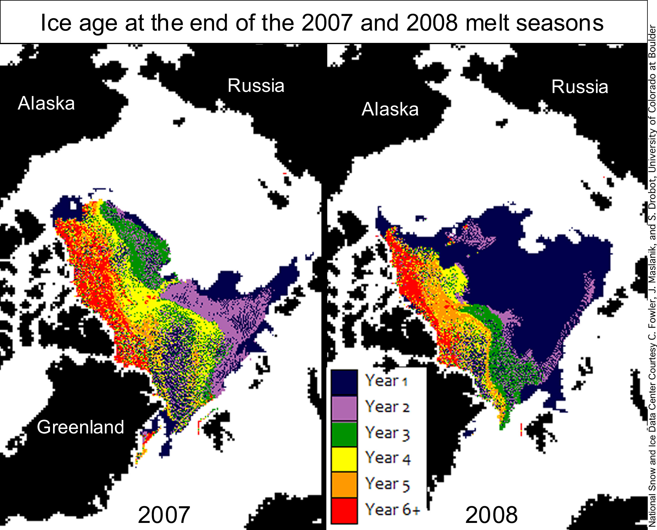
NSIDC made a big deal about loss of multi-year ice in the Arctic during 2007-2008, but this was due more to drift in the winter than melting in the summer, as can be seen in the NSIDC map pair below. Note that most of the 2007 multiyear ice was replaced by first year ice after the 2007 melt season ended and (necessarily) before the 2008 melt season started. The only way this could have happened was due to drift during the 2007-2008 winter, i.e. it could not be the result of summer melt -because ice only forms in the winter.

If the ice is not drifting (i.e. not under tensile stress) the concentration should be high. This indeed appears to be the case. According to UIUC maps, sea ice concentration is high (above 90%) across the Arctic Basin.
http://arctic.atmos.uiuc.edu/cryosphere/NEWIMAGES/arctic.seaice.color.000.png
The Arctic ice minimum extent increased by about 25% between 2007 and 2009, and many indications (negative AO, light drift, high concentration) point to the idea that it will continue to increase in 2010.

http://www.ijis.iarc.uaf.edu/seaice/extent/AMSRE_Sea_Ice_Extent.png
We can also expect that the average age of the ice has increased this winter, continuing a trend started in 2009.

Here’s your chance to weigh in:
Prediction: Arctic Ice Will Continue to Recover this Summer
NSIDC regularly puts out a news article describing the deteriorating state of the Arctic, called the Sea Ice News. In their May 5, 2008 article, they stated:
the Arctic Oscillation was in its positive phase through the winter season, associated with a wind pattern helping to flush thick ice out of the Arctic, leaving thinner ice. This is one of the factors helping to set the stage for pronounced ice losses this summer.
Additionally, Dr. Walt Meier from NSIDC told WUWT:
The NAO/AO (Arctic Oscillation) is a particularly prominent one and a substantial amount of the decline in the sea ice during the late 1980s and early 1990s could be attributed to a strong positive mode during winters because the positive mode favors the loss of thicker ice (through drift) that is less likely to melt during summer.
In their January 5, 2010 article NSIDC states that we are in an “Extreme negative phase of the Arctic Oscillation” which can be seen in this NOAA graph below. Oddly (but not surprisingly) the article failed to mention how this affects drift.

If a positive Arctic Oscillation flushes out the Arctic into the Atlantic, the implication is that a negative phase would tend to retain ice. This indeed appears to be the case. Arctic buoys show very light polar drift this winter.

NSIDC made a big deal about loss of multi-year ice in the Arctic during 2007-2008, but this was due more to drift in the winter than melting in the summer, as can be seen in the NSIDC map pair below. Note that most of the 2007 multiyear ice was replaced by first year ice after the 2007 melt season ended and (necessarily) before the 2008 melt season started. The only way this could have happened was due to drift during the 2007-2008 winter, i.e. it could not be the result of summer melt -because ice only forms in the winter.
If the ice is not drifting (i.e. not under tensile stress) the concentration should be high. This indeed appears to be the case. According to UIUC maps, sea ice concentration is high (above 90%) across the Arctic Basin.

http://arctic.atmos.uiuc.edu/cryosphere/NEWIMAGES/arctic.seaice.color.000.png
The Arctic ice minimum extent increased by about 25% between 2007 and 2009, and many indications (negative AO, light drift, high concentration) point to the idea that it will continue to increase in 2010.

http://www.ijis.iarc.uaf.edu/seaice/extent/AMSRE_Sea_Ice_Extent.png
We can also expect that the average age of the ice has increased this winter, continuing a trend started in 2009.
Poll:
What will the 2010 Summer Arctic Sea Ice Extent Be?
It will be greater than 2009
It will be greater than 2008 but not 2009
It will be less than 2007
It will be near normal
The North pole will be “ice Free” in 2010
http://bishophill.squarespace.com/
Interesting comments from Andrew Lacis on Bishop Hill Blog.
You won’t believe it.
I believe 2010 will be 2006-ish.
I’m skeptical of 500K sq km more. The arctic has been warm over the last 6 months. I think it will be a bit below 09.
It still don’t get why drift favours thinner ice over thicker.
The JAXA ice graph shows about the same acreage as in the 2007 low year, despite the good summer/fall recovery in 2009.
What’s your rationale Steve for the thickening; is it just that temperatures are lower; or is there a lot of precipitation on top of the growing sea ice; or is it something else ? Would an El Nino condition that we apparently now have result in a lot of Arctic precipitation ?
http://igloo.atmos.uiuc.edu/cgi-bin/test/print.sh?fm=02&fd=01&fy=2007&sm=02&sd=01&sy=2010
Is it me or the ice looks much healthier than in 2007, before the record summer minimum?
I bet it is thicker as well. Recent slower growth and even temporary retracts are due to compaction (thicker ice). It will show its quality next September.
Temperatures in the Arctic have been plenty cold, averaging close to minus 30C.
http://ocean.dmi.dk/arctic/meant80n.uk.php
The key thing which determines growth in ice thickness during the winter, is drift. During 2007, lots of older ice melted during the winter because it blew out into the warm waters of the North Atlantic (remember the crusty ice that summer?) This year, drift is light because of the negative Arctic oscillation. So the ice is largely growing thicker in situ.
Extent anomalies are nearly meaningless at this point in the winter. The “missing” ice is in the first places to melt in spring.
http://nsidc.org/data/seaice_index/images/daily_images/N_daily_extent.png
Note that in the AMSR-E graph, 2006 had the lowest February extent, but had one of the highest summer extents.
From the comments, it appears that the process of Artic Ice formation and loss is not fully understood by anyone. Does it give any indication of a warming/cooling trend? Or is there insufficient data to answer the question? As a mere taxpayer, I would like to know when I can have my barbeque Summer. Alternatively give me my money back.
The ice extent won’t change much, but it will surely be a lot thicker. I don’t expect a summer melt any longer than the ‘brief’ 2009 season was.
The Warmists make a big deal about sea ice loss overheating the planet.
If someday what happened in the Arctic in 2007 gets repeated in the Antarctic, that last effect we’ll get out of it is an overheating. It will be the Big Chill in the S. Hemisphere.
Next time you take a hot bath, perform this experiment. Grab a bucket of ice cubes and dump them in after you’ve settled in.
Thanks Steve. I have enough balls in the air to keep track of right now; so it is nice to have someone who understands it, explain what is going on.
George
The North pole will be “ice Free” in 2010 2% (3 votes)
Three trolls stopped by.
it’s good to see Steven Goddard back
he has a good track record for predictions too
This may be a dumb question, but if there is less Arctic drift, could that account for the record warmth in Jan. that is due to warmer oceans? Less drift would mean less ice melting and cooling the oceans. Or am I full of it?
http://portal.fma.fi/sivu/www/baltice/ice_forecast
http://www.smhi.se/oceanografi/istjanst/produkter/icechart.png
The bay of Bothnia has already frozen over
The Bothnia sea is freezing more and more every day now.
The bay of Finland is frozen .
In a few more weeks with this cold we can walk from Stockholm
to St. Petersburg on ICE.
//Lars
Anyone who has been on sea ice knows it is always headed somewhere. It is not like the impounded pond ice. Ice extent is a non-static balance between outflow and refreeze. So now the conveyor belt has slowed down a little and ice manufacture is getting the upper hand. My guess is that arctic ice loss in summer is 20% melt and 80% transport.
Marcia,
Thanks. I’m enjoying writing again for the #1 science blog.
Anthony’s blog has even educated the Guardian and NYT – no small feat.
For me all I see is the little red 2010 trend down below or level with 2007, so I cant see the positives here? Unless we are talking thickness (something positive in another area of every mans life….)
TA,
My theory about January TLT warmth (I may write an article about this) is that a combination of El Nino and a deeply negative AO drove the temperatures at 14,000 upwards. A negative AO means that cold air is sinking from higher elevations and is being replaced by warm air from the ground. As dramatized in the movie “The Day After Tomorrow.”
http://nsidc.org/arcticmet/patterns/arctic_oscillation.html
Note the very warm spot over Canada and Greenland at + 4C.
http://www.remss.com/data/msu/graphics/tlt/medium/global/ch_tlt_2010_01_anom_v03_2.png
Ground temperatures in Canada and Greenland were above normal, but not that much. Also, the MSU near-surface readings had a much lower anomaly than TLT.
My point is that I think the satellite TLT readings are exaggerated for January because of the elevation they are measured at. In 1998, UAH and RSS showed a much larger spike than GISS or Had-Crut.
After reading the predictions of the (professional) experts last summer, I am convinced that nobody has a clear idea what is going on. Furthermore, the extend of September 2010 depends mainly on what is happening in July-August 2010.
Up to now the ice minimum has never grown 3 years in a row (“never” meaning: since 1979). Therefore the safest guess seems to me about 4.8 M sq km.
Steve Goddard (09:23:51) :
Temperatures in the Arctic have been plenty cold, averaging close to minus 30C.
http://ocean.dmi.dk/arctic/meant80n.uk.php
They’ve only been about 5ºC warmer than average for the last 6 months.
The key thing which determines growth in ice thickness during the winter, is drift. During 2007, lots of older ice melted during the winter because it blew out into the warm waters of the North Atlantic (remember the crusty ice that summer?) This year, drift is light because of the negative Arctic oscillation. So the ice is largely growing thicker in situ.
What makes you think drift is light? Here’s a comparison between the last week of Jan this year and in 2007.
http://i302.photobucket.com/albums/nn107/Sprintstar400/Drift2010vs07.jpg
I’d be very surprised if the arctic sea ice minimum isn’t at or below 2007 levels. The SST near the edge of the sea ice on the Atlantic side has been well above normal all winter hence the low extent this winter. Drift out off the Fram has been normal to high starting with younger, more fragmented ice. It will need some freaky summer weather to be otherwise I think.
If this article is right, the arctic ice will increase for the third year in a row for the first time since 1979.
Phil,
Is minus 30C cold enough to freeze seawater?
The 2007-2009 minimums have been dominated by loss of ice in the western Arctic, not the east. Drift in the western Arctic has been close to zero this winter, and Bering Strait ice is above normal.
My guess is slightly less than 2009. This is based on pure gut feeling and a guess that the Arctic polar vortex will have a weaker than average winter, spilling cold air further down the NH than happened in 2009.
I think even the experts are going to have a tough time calling this one!
Phil,
WUWT predicted 2009 ice correctly last March – while NSIDC was still mulling about a possible record minimum as late as July.
http://wattsupwiththat.com/2009/03/02/poll-and-polar-ice-trends/
I also called Serreze on his ice free North Pole prediction in 2008.
http://www.theregister.co.uk/2008/07/03/goddard_polar_ice/
But it’s only going to be 3 year old ice! The New Rule this year is that only 4 year old ice Counts!!!