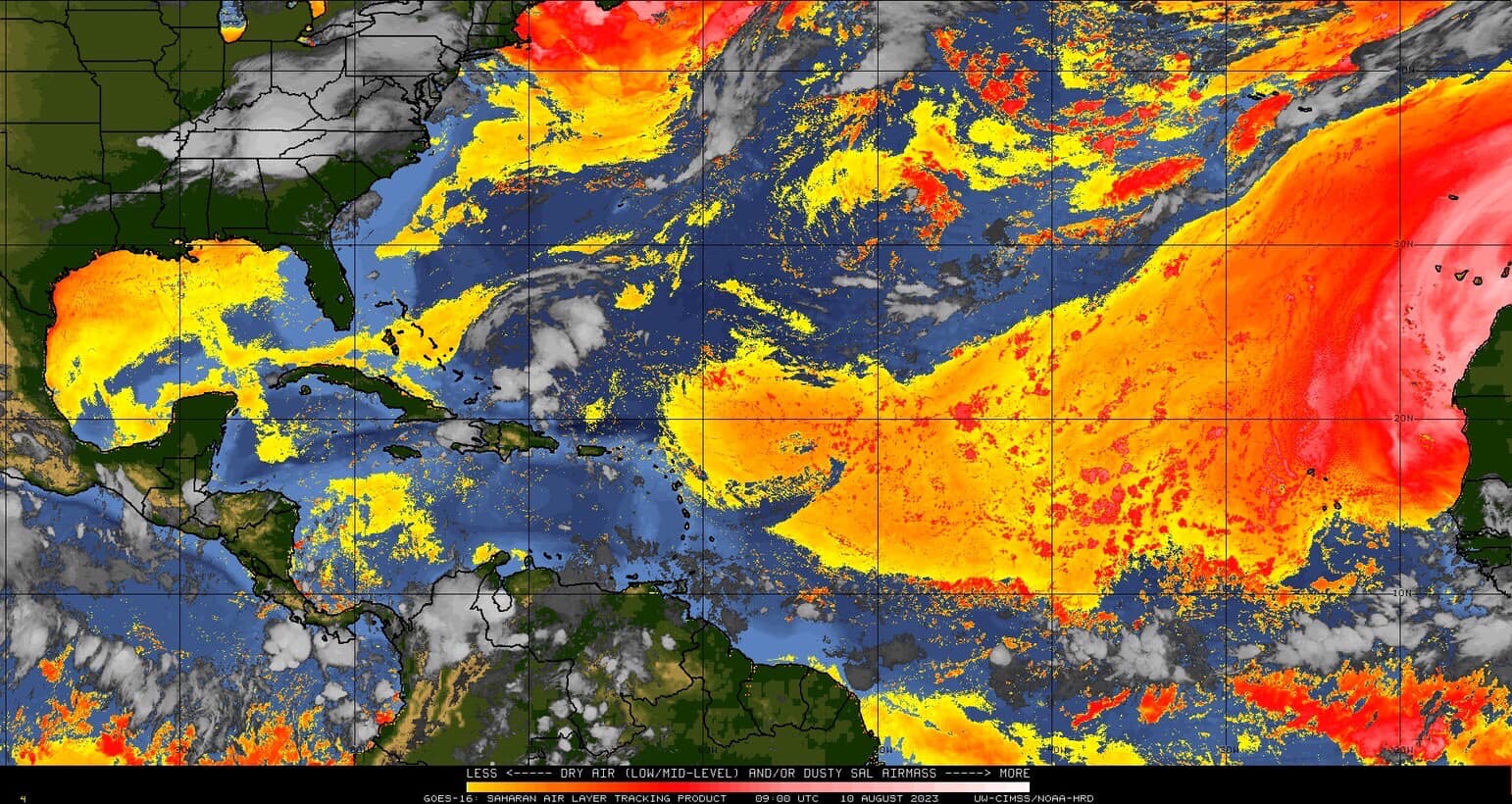
This is a satellite picture with the colors showing dry air & Sahara Dust coming across the Tropical Atlantic. This has prohibited the development of tropical storms over the region. The water is very warm so after the dust disperses there is a risk for strong hurricane to develop as we get later in the month!
And there you have it, “dust in the wind” is preventing formation of “Cape Verde” type hurricanes. NOAA has a description here.
The Saharan Air Layer, also known as Saharan Dust, is made of sand, dirt, and other dust that is lifted into the atmosphere from the vast desert area that covers most of North Africa. This dust is carried in the African Waves which push westward into the Atlantic Ocean.
The Saharan Air Layer is a well-mixed dry pocket of air that usually resides between 5,000 and 15,000 feet above sea level. Since one of the key ingredients for tropical cyclone development is a deep feed of moisture, Saharan Dust often acts to inhibit tropical development.
Once a pocket a Saharan Dust begins moving westward over the Atlantic, it is relatively easy to track using infrared satellite products.
An excuse for a slow hurricane season after earlier predictions of a busy season due to “global heating”. Careless and shameless astrologers with a gov’t paycheck is all they are.
El nino years are noted for having less than average number of tropical storms in eh Atlantic Basin.
So anyone predicting more than usual based on ocean water temps is making a guess with little basis in historical trends.
And all such forecasts are just that, guesses.
No one can possibly know ahead of time how many there will be, where they will form if they do, how strong they will get, and where they will move.
Only once conditions are good and a storm forms do forecasts have much value at all.
On a different note, Sahara dust inhibits storm formation via a few mechanisms, but the most important is probably that the dust absorbs solar energy and thus heats up the layer in which the dust resides.
Warm air aloft inhibits convection all by itself, strongly.
Rising air needs to continuously rise into cooler air as it rises and cools, or it will stop rising.
IOW, the environmental lapse rate must be higher than the adiabatic rate.
Warm layers aloft are called cap layers, because they stop convection from occurring. Sometimes the temp actually rises with height, and this is called an inversion. This is the most stable at atmosphere can be. Clouds cannot form in an inversion layer, period.
No clouds, no convection, and nothing to organize into a tropical cyclone.
But it is uncommon for storms to form prior to the end of August. At that point, the odds shoot way up quickly, for a whole bunch of climatological reasons. So there is nothing unusual at all for nothing to form at this time of year. Most years have nothing on the map at this point, except some tropical waves.
In the huge tropical storm years of 2004 and 2005, tropical activity was very quiet until the end of August, and then it was like someone flipped a switch, and every area of clouds seemed to rapidly develop.
There is an inverse relationship between activity in the Pacific and Atlantic basins, which a lot of activity in one basin rarely coinciding with a lot of activity in the other.
There are actually two regions of Pacific development, East and West, and rarely do they overlap at all. Storms that form off the coast of Mexico almost never get anywhere near Hawaii, and at this time of year, it is common for storms to be forming one after another in the Pacific near Mexico.
Eastern Pacific is already up to 99 investigation areas so far this year,
Western Pacific has two named storms on the map right now, the 5th and 7th of the season in that basin: RAL | Tropical Cyclone Guidance Project | Real-Time Guidance (ucar.edu)
Activity this year seems to be high in Western Pacific Basin, which most often means we will have a light season in the Atlantic.
But this are very general trends, and it also says nothing about where one will hit or how strong one might get if it forms.
And it can be the quietest season ever, but if a single powerful one forms and hits where you live, it may seem like the worst season ever.
Climatologically, less that 10 per hundred years can be expected to be on the map on August 12th.
A month from now, the number is over 50.
Also a month from now, >90 tropical storms per 100 years will be on the map.
But even this frequency can be misleading: Some years have a bunch on the map at Labor Day, and many years have zero.
October 1-20th has roughly 3 to 5 times as much tropical cyclone activity in the Atlantic Basin as August 1-20th.
It is almost always “slow” at this time of year. That is why it is slow.
If conditions are not favorable, TS formation is highly unlikely, and intensification nearly impossible. Water temp is a red herring. Warm water cannot by itself cause tropical cyclones. If it could, there are places that almost never have any, that would have very many.
ResourceGuy
August 11, 2023 10:42 am
“Sand, dirt, and other dust” Has clay become a banned word when I wasn’t looking?
not much clay left in the Sahara… maybe the commenter was more sophisticated that usual, or maybe just incomplete. Dunno. We edge into silt, loam and grabben. LOL
Dust from the Sahara is organic pollen from ancient times. Sand and clay will not last long in the air. This dust traps much of the sun’s radiation, which does not reach the surface.
In the Sahara and Arabian deserts one does not get sunburnt as easily as one might expect despite 40 -50 Deg C temperatures and cloudless skies.A breeze blows pretty constantly and I think the resulting dust acts as a UV filter
Nahhhh. It’s not ancient pollen.
The very fine pollen would have all blown away 1000’s of years ago – any that’s left will be well buried and out of reach from being picked up by the wind.
Doubly well buried by the endlessly drifting dunes
Periodically the wind direction is such that Sahara dust makes it to the UK, giving us orange skies and orange vehicles as it settles out of the atmosphere or is precipitated by rain.
I think you are right.
It is not pollen, that is ridiculous, and it is not sand, the particles are too heavy by orders of magnitude for all but the finest of fine sand, to be suspended in the air miles up. Even more ridiculous.
There is some pollen in almost every air sample in the low to mid latitudes, so there is not zero pollen, but it is not a major constituent by any means.
Geologically, “dust” is not defined. But sand, silt, clay…those denote specific particle sizes, which all by itself gives rise to particular characteristics due to surface area per unit weight of material, cation exchange capacity, static charge, etc.
Sahara Dust events consist of particles up to about 50 micrometers, but most, >99.5%, of particles are about 2.5 micrometers or less, placing them in the range of almost all clay particles by count, with a little up to the size of course silt. Since the silt particles are so much more massive than the clay, by weight the dust is likely to be primarily silt particles.
The cutoff between fine sand and course silt is about 62 micrometers.
Another nae for such material is “fugitive dust”, and it is nearly all mineral by composition and origin.
Who thinks a haboob is pollen?
Household dust on the other hand, is mostly organic, with a large amount of it things like dead skin cells, dust mite castings and feces, etc.
Assuming, assuming that the theory which says Saharan Dust is a massive source of nutrition for the Amazon Forest – there pretty well has to be clay in the dust
Because clay is (can be) extremely fertile soil and that comes from 2 connected parts.
That the Mica (Aluminium Silicate Hexahydrate) that clay is has huuuuge affinity for water.
All the useful plant nutrients are water soluble so when water penetrates into the mica sheets/lattice, it carries those little nuggets of goodness with with it
OK the water can dry out maybe but many of the metal ions will stay there in the mica lattice – like dehydrated or plastic wrapped food.
Then when the Saharan wind picks it up and takes it to Amazonia and the *rain* forest – the rain rehydrates it and releases the nutrition.
neat huh
You have no idea what you are talking about. -Everything is soluble in water to some degree, but some important micronutrients are often locked up in minerals that are not very soluble in water.
-The term “clay” denotes a particle size, not a particular mineral.
-The Amazon, like all tropical soils, have very deep horizons highly enriched in aluminum. In fact, tropical soil is the source of bauxite.
This is because of high leaching rates due to hundreds of inches of rain a year. Aluminum minerals are among the least soluble of minerals, so they remain and the soil becomes enriched in aluminum.
-Iron minerals also accumulate in oxisol horizons. Iron in Saharan dust is not in a soluble form. Ligands are required to make it bioavailable when, for example, it settles onto the ocean and fertilizes phytoplankton. Iron is a limiting nutrient over the open ocean basins.
Soils from arid regions are not leached, while tropical soils are highly leached.
Aridisols vs oxisols.
-Phosphates are nearly depleted from the soils in the Amazon, and it is this phosphate that is thought to be critically important when it is imported by wind from the Sahara to the Amazon.
-Hydration has nothing to do with why that dust is important in the Amazon.
As for iron, acidification and photochemical reactions are what makes the iron more bioavailable for phytoplankton.
Summary: Clay is a particle size, not a mineral type. There are places where some of the dust comes from, notably a dry lake bed in Chad, which is highly enriched in phosphate. That is what is thought to be important about Sahara dust transported to the Amazon. Some calcium and potassium too.
Phosphate is a limiting nutrient in Amazon tree growth, since almost all nutrients are locked up in plants, not in the soil as is the case where alfisols and aridisols are dominant
Facts are much neater that crap you made up that is wrong.
“Dust” should be identified….the term is used in space too…”dust”. Get a microscope…run some tests…identify the “dust”…..it is elements and compounds but not named for some reason.
Climatologically, the Gulf Of Mexico is a favored region for tropical development early and late in the season. Mainly from the remnants of old cold fronts. Not common in July and August.
July and early August rarely see any storms form in the Atlantic basin.
Here in Fort Lauderdale you can sometimes see the Sahara dust as unusually ‘red’ sky near sunrise/9sunset.
Nice because we have so far had a quiet tropical storm season.
Same here in Fort Myers/Naples area. Lots of pretty sunrises and sunsets, but during the day the atmosphere looks sorta dull and almost smog like (we get no smog here ever). We usually get Saharan dust here but usually it’s in the late spring and early summer, but goes away when the typical pattern of afternoon and evening T-storms takes over.
Let’s flash back to this time last year. No idea that Ian was going to happen. No idea that so many lives would be destroyed with so many still not back to pre-Ian normalcy all these months later. No criticism, just saying you never now what is in store in the near future. So we stay prepared and hope for the best.
It is impossible to say anything about what is coming based on the number of early storms.
In 2004, Alex formed on July 31, the latest ever date at that point in time for a first named storm. It wound up one of the busiest, deadliest and most costly seasons on record at the time.
2005 was the worst on record on several metrics, including most ever names storms (since eclipsed, since they now name swirls of clouds lasting hours and way out over the north Atlantic).
The forecasts for what was to come was grim and alarmist.
Then came 2006, the quietest season on record, and it was followed by the longest major hurricane drought in US and Gulf of Mexico history.
Donna hit in what, 1960? 58 years later another one like it hit the same places with similar intensity.
Charley, 2004, Ian, 2022, same spot at landfall.
Best place it could have hit, arguably. Everything had been rebuilt to beefed up standards and codes.
Dade County is still waiting for another one like Andrew.
I think the last one to hit Fort Lauderdale and Palm Beach county extremely hard was almost a hundred years ago.
Of course, people over there think the remnants of Wilma was Godawful and Ian was a stiff breeze. Wilma did mess up a lot of really nice and very large ficus trees. And reminded people that terra cotta roof tiles are not heavy and are best not just left sitting loose on the roofs.
The truth is, by historical standards, a lot of the US has been very lucky for many many decades.
The early 20th century had powerful hurricanes hit places like New Jersey, New York, New England, so hard and so many times, when I was a kid the shore points up there were sparsely inhabited even in Summer and ghost towns in the Winter.
The lists of deadly floods caused by hurricanes in the northeast US is as long as my arm, but a couple years ago, most people seemed to think it was the first time Philly had EVER been flooded due to rains from a hurricane.
But I recall Agnes flooding so was bad, the Schuylkill River was all the way from 25th street in Center City almost to the edge of Franklin Feild at U of P.
Here is good advice for anyone who does not want to have to rebuild a home: Do not live near any water, anywhere. You may not get hit for decades in a row, or one may flood you a dozen times in the next 20 years.
Or just give everything away and wear a hairshirt: Democrats assure me that we can end bad weather if we are all in poverty and suffering terribly.
Ed Zuiderwijk
August 11, 2023 11:44 am
Really? I for one don’t believe any of it.
There used to be a dust monitor at the La Palma astronomical observatory, keeping track of the load of Saharan dust in the upper atmosphere, for obvious reasons. In the 25 odd years of its operation no anti-correlation or correlation was found with the hurricane frequency in the north Atlantic.
Me neither – what we read there is a description of the Emperor’s wardrobe
What exactly is a ‘deep feed’
In any case, that’s garbage as well.
A hurricane needs a thunderstorm, a big one coming from lots of heat in the surface water, NO wind shear above it and a steep lapse rate
Then it can crank itself up properly
The extra strong heat (not esp temperature) is near perfectly sourced by dirty sea-water = trapping solar energy in the top 20 or so metres of water rather than the top 100 metres
So, the Sputnik here is correct but for all the worng reasons.
Sputnik says the dust (potential muddy water) is all up in the sky and blowing away out to sea and *not* falling into the water near Cape Verde isles
THAT is why no hurricanes.
If the wind was calmer, dropping its load near the islands, *then* a hurricane might start.
The Sputnik picture is beautiful innit – it marks out the exact track almost all hurricanes take as they cross the pond. Innit perfect?
i.e Hurricanes follow their noses and their noses are sensitive to muddy water.
Why not, that’s where The Heat is – near the surface and concentrated in the top 20 or so metres.
Testable prediction: If when a hurricane does fire up, what we need is an aerial view of how muddy the water is ahead of it.
I say that the ‘cane will follow the muddiest part – instead of the random and ever expanding wandering walk that computers predict.
The ‘cane knows *exactly* where it’s headed = where the densest energy is.
if we can’t get those aerial shots of the water, look inland at where any heavy rain has fallen recently – the mud will be pouring out of the river(s) there and the hurricane will aim for that.
It’s here, we see it every day in Florida. Don’t need a monitor to see what my eyes see, and experience the effect it has on our weather here which is a very unusual pattern for mid to late summer in Florida.
Yes. For example here in Fort Lauderdale we usually have significant Tstorms forming over the Everglades and moving east ( cause their convective cloud bottoms are above the low afternoon onshore sea breeze pushing west to the Everglades.) Today was very ‘Sahara dusty’
—tannish hazy at midday with no sugar cane being burned south of Okeechobee, and zero Tstorms. Also less than usual normal clouds.
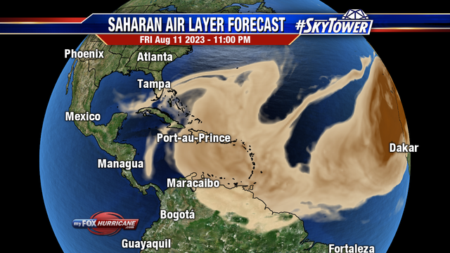
Also the axis of the subtropical high is further south than usual. That’s keeping African easterly waves further south in an unfavorable formation zone. The axis will move north as we approach the peak of the season and activity in the Main Development Region will increase.
That is an interesting graphic but wind cannot move clear across the Atlantic at anything approaching the apparent speed of that animation. What is actually being shown? Does evidence exists that it bears any relationship what so ever to reality?
As a full time resident of south Florida, hit hard last year by Hurricane Ian, I can attest that the air here has been dominated by high altitude dust. It creates a certain dullness in the air during daytime, and contributes to fiery sunrises and sunsets. It’s also been an uncommonly dry summer for us – which is a typical occurrence when El Nino predominates as it is. It creates high pressure domes over the eastern half of the country particularly in the southern tier of states.
It gets rather hot (mid 90s) during the day, unless and until we get a rainstorm that immediately cools the air by 10-15 deg F. In our uncharacteristic summer so far, we are not seeing our typical pattern of afternoon and evening thundershowers, rather we either get no rain or we get our rainstorms in the morning, which is quite unusual for Florida.
Is this due to global warming? Of course not. It’s called “weather”, and this year the El Nino is shaping up to be a particularly warm one which appears to account for our unusual weather this summer to date.
Of course, things can change rather quickly. Last year we had well below normal tropical cyclone activity in the Atlantic through August and into early September. Anyone who’s lived in Florida a few decades or more like me knows one can never relax, because the worst storms typically don’t arrive until late September or even October. Well, sure as poop, Hurricane Ian arrived here on September 28 as the most damaging storm in Florida history, from which we are still struggling to recover. But Cat 4/5 hurricanes come ashore somewhere here in Florida every few years, and that’s been documented ever since the first Spanish conquistadors arrive here more than 500 years ago (even Columbus suffered from at least two major hurricanes during his several years in Cuba).
That is a component I had not seen. But, seen — it makes sense.
The deserts under the red color are identified here: Reddit –?auto=webp&s=fea40fa19c8722817710fbd4f47e3469295079ad
Some years ago, there was an article, I think here, about how hurricanes or more accurately, their precursors, could be tracked across Asia and then North Africa and the Atlantic. I didn’t take time to look for it tonight. But the concept does not surprise me.
Dave O.
August 11, 2023 1:13 pm
Alarmists: We always have to have an emergency backup excuse in case our predictions don’t pan out. Just so it doesn’t conflict with the “climate change” narrative.
So … “Climate Change/CAGW” will cause more and more intense hurricanes.”
But not this year because weather-caused dust will prevent and/or hinder it from happening?
If it wasn’t for the weather, everybody would see how catastrophic climate change is!
Gunga Din, your quote reminded me of the prognostication that climate change/CACW is also supposed to increase the frequency and strength of El Nino events in the tropical Pacific. The two prognostications are incompatible, because El Nino events suppress hurricane formation in the tropical North Atlantic by basically chopping the tops off the hurricanes.
Agreed, it is one of the reasons why Hurricanes have shown no increase in frequency or strength over the recent decades. An increase in El Nino’s since the 1980’s has been responsible for this.
“El Niño produces stronger westerly wind at upper levels of the atmosphere across the tropical Atlantic than in normal non-El Niño seasons. This increases the total vertical wind shear, basically shearing the tops from developing storms before a healthy circulation can form.”
The idiot should have researched BEFORE buying. Tow capability minimal. Haul capability minimal. Range limited. He found out the hard way at a cost of $130k.
If he wanted to virtue signal, there is a nifty hybrid F150 that even provides four AC power outlets in the bed (for power tools), with the hybrid engine running as the ‘generator’.
The hybrid bat will need replacement one day….maybe end the life of vehicle due to cost….repairs more complex and expensive….new vehicles are becoming more and more electronic and plastic….not good for longevity.
We own a MY 2007 Ford hybrid Escape AWD with class 1 tow hitch (tow motorcycles). 14 years on, the traction battery is still good at ~90,000 miles. Used as taxis in NYC, such hybrid Escapes have reached 300,000 miles.
Love our 14 Avalon Hybrid! 215k and only maintenance have been oil changes and tires – regen brakes are still solid. Gets 35-40 mpg, depending on how often my foot gets impatient.
Everyone knows that hurricanes are caused by butterflies in west Africa flapping their wings and causing a circular air motion that develops into a low pressure system off the coast of Africa.
John Hultquist
August 11, 2023 5:40 pm
The peak of the H. season is Sept. 10th
Search. My last attempt at a web link (world deserts) looks trashy.
Ireneusz Palmowski
August 11, 2023 10:32 pm
Abstract
The productivity of the Amazon rainforest is constrained by the availability of nutrients, in particular phosphorus (P). Deposition of long-range transported African dust is recognized as a potentially important but poorly quantified source of phosphorus. This study provides a first multiyear satellite-based estimate of dust deposition into the Amazon Basin using three-dimensional (3-D) aerosol measurements over 2007–2013 from the Cloud-Aerosol Lidar with Orthogonal Polarization (CALIOP). The 7 year average of dust deposition into the Amazon Basin is estimated to be 28 (8–48) Tg a−1 or 29 (8–50) kg ha−1 a−1. The dust deposition shows significant interannual variation that is negatively correlated with the prior-year rainfall in the Sahel. The CALIOP-based multiyear mean estimate of dust deposition matches better with estimates from in situ measurements and model simulations than a previous satellite-based estimate does. The closer agreement benefits from a more realistic geographic definition of the Amazon Basin and inclusion of meridional dust transport calculation in addition to the 3-D nature of CALIOP aerosol measurements. The imported dust could provide about 0.022 (0.006–0.037) Tg P of phosphorus per year, equivalent to 23 (7–39) g P ha−1 a−1 to fertilize the Amazon rainforest. This out-of-basin phosphorus input is comparable to the hydrological loss of phosphorus from the basin, suggesting an important role of African dust in preventing phosphorus depletion on timescales of decades to centuries. https://agupubs.onlinelibrary.wiley.com/doi/full/10.1002/2015GL063040
Ireneusz Palmowski
August 11, 2023 10:35 pm
This trans-continental journey of dust is important because of what is in the dust, Yu said. Specifically the dust picked up from the Bodélé Depression in Chad, an ancient lake bed where rock minerals composed of dead microorganisms are loaded with phosphorus. Phosphorus is an essential nutrient for plant proteins and growth, which the Amazon rain forest depends on in order to flourish.
Nutrients – the same ones found in commercial fertilizers – are in short supply in Amazonian soils. Instead they are locked up in the plants themselves. Fallen, decomposing leaves and organic matter provide the majority of nutrients, which are rapidly absorbed by plants and trees after entering the soil. But some nutrients, including phosphorus, are washed away by rainfall into streams and rivers, draining from the Amazon basin like a slowly leaking bathtub.
The phosphorus that reaches Amazon soils from Saharan dust, an estimated 22,000 tons per year, is about the same amount as that lost from rain and flooding, Yu said. The finding is part of a bigger research effort to understand the role of dust and aerosols in the environment and on local and global climate. https://www.nasa.gov/content/goddard/nasa-satellite-reveals-how-much-saharan-dust-feeds-amazon-s-plants
Sahara dust is also a contributor to red tide blooms in the Gulf of Mexico.
William Howard
August 12, 2023 5:36 am
amazing – I read some time ago that the Sahara dust was also a big factor in causing the NA glaciers to retreat – man is so utterly irrelevant to changes in the climate
This is interesting, and not just a “idea”. When we lived in the Caribbean (for more than a decade), strong Saharan dust events would result in the nice white decks of our sailboat getting coated with fine red powder — just enough to make the white not-so-white. Wiping the deck with a clean rag would reveal the red Saharan dust that had settled overnight.
NOAA continues to spout hopeful forecasts that they can then attribute to the dreaded Climate Change®.
https://www.nesdis.noaa.gov/news/noaa-releases-updated-2023-atlantic-hurricane-season-outlook
An excuse for a slow hurricane season after earlier predictions of a busy season due to “global heating”. Careless and shameless astrologers with a gov’t paycheck is all they are.
El nino years are noted for having less than average number of tropical storms in eh Atlantic Basin.
So anyone predicting more than usual based on ocean water temps is making a guess with little basis in historical trends.
And all such forecasts are just that, guesses.
No one can possibly know ahead of time how many there will be, where they will form if they do, how strong they will get, and where they will move.
Only once conditions are good and a storm forms do forecasts have much value at all.
On a different note, Sahara dust inhibits storm formation via a few mechanisms, but the most important is probably that the dust absorbs solar energy and thus heats up the layer in which the dust resides.
Warm air aloft inhibits convection all by itself, strongly.
Rising air needs to continuously rise into cooler air as it rises and cools, or it will stop rising.
IOW, the environmental lapse rate must be higher than the adiabatic rate.
Warm layers aloft are called cap layers, because they stop convection from occurring. Sometimes the temp actually rises with height, and this is called an inversion. This is the most stable at atmosphere can be. Clouds cannot form in an inversion layer, period.
No clouds, no convection, and nothing to organize into a tropical cyclone.
But it is uncommon for storms to form prior to the end of August. At that point, the odds shoot way up quickly, for a whole bunch of climatological reasons. So there is nothing unusual at all for nothing to form at this time of year. Most years have nothing on the map at this point, except some tropical waves.
In the huge tropical storm years of 2004 and 2005, tropical activity was very quiet until the end of August, and then it was like someone flipped a switch, and every area of clouds seemed to rapidly develop.
There is an inverse relationship between activity in the Pacific and Atlantic basins, which a lot of activity in one basin rarely coinciding with a lot of activity in the other.
There are actually two regions of Pacific development, East and West, and rarely do they overlap at all. Storms that form off the coast of Mexico almost never get anywhere near Hawaii, and at this time of year, it is common for storms to be forming one after another in the Pacific near Mexico.
Eastern Pacific is already up to 99 investigation areas so far this year,
Western Pacific has two named storms on the map right now, the 5th and 7th of the season in that basin:
RAL | Tropical Cyclone Guidance Project | Real-Time Guidance (ucar.edu)
Activity this year seems to be high in Western Pacific Basin, which most often means we will have a light season in the Atlantic.
But this are very general trends, and it also says nothing about where one will hit or how strong one might get if it forms.
And it can be the quietest season ever, but if a single powerful one forms and hits where you live, it may seem like the worst season ever.
Climatologically, less that 10 per hundred years can be expected to be on the map on August 12th.
A month from now, the number is over 50.
Also a month from now, >90 tropical storms per 100 years will be on the map.
But even this frequency can be misleading: Some years have a bunch on the map at Labor Day, and many years have zero.
October 1-20th has roughly 3 to 5 times as much tropical cyclone activity in the Atlantic Basin as August 1-20th.
It is almost always “slow” at this time of year. That is why it is slow.
Right about now is when Cape Verde activity starts to ramp up, and spikes at eh very end of August.
Graph-of-hurricane-frequency-for-the-Atlantic-Ocean-hurricane-season-Image-credit-NOAA.png (640×421) (researchgate.net)
If conditions are not favorable, TS formation is highly unlikely, and intensification nearly impossible. Water temp is a red herring. Warm water cannot by itself cause tropical cyclones. If it could, there are places that almost never have any, that would have very many.
“Sand, dirt, and other dust” Has clay become a banned word when I wasn’t looking?
not much clay left in the Sahara… maybe the commenter was more sophisticated that usual, or maybe just incomplete. Dunno. We edge into silt, loam and grabben. LOL
Dust from the Sahara is organic pollen from ancient times. Sand and clay will not last long in the air. This dust traps much of the sun’s radiation, which does not reach the surface.
In the Sahara and Arabian deserts one does not get sunburnt as easily as one might expect despite 40 -50 Deg C temperatures and cloudless skies.A breeze blows pretty constantly and I think the resulting dust acts as a UV filter
Is there any sort of pollen that isn’t organic?
Nahhhh. It’s not ancient pollen.
The very fine pollen would have all blown away 1000’s of years ago – any that’s left will be well buried and out of reach from being picked up by the wind.
Doubly well buried by the endlessly drifting dunes
Periodically the wind direction is such that Sahara dust makes it to the UK, giving us orange skies and orange vehicles as it settles out of the atmosphere or is precipitated by rain.
This shows essentially no organic matter in the air downwind from the Sahara.
https://earth.nullschool.net/#2023/08/12/0100Z/particulates/surface/level/overlay=organic_matter_aot/orthographic=-38.03,22.94,434
It’s what we call “rock flour” – very fine particles of silicate minerals produced by the constant abrasion of wind-blown sand (and gravel on very windy days) on other grains of sand and gravel or pebbles, boulders etc.
I think you are right.
It is not pollen, that is ridiculous, and it is not sand, the particles are too heavy by orders of magnitude for all but the finest of fine sand, to be suspended in the air miles up. Even more ridiculous.
There is some pollen in almost every air sample in the low to mid latitudes, so there is not zero pollen, but it is not a major constituent by any means.
Geologically, “dust” is not defined. But sand, silt, clay…those denote specific particle sizes, which all by itself gives rise to particular characteristics due to surface area per unit weight of material, cation exchange capacity, static charge, etc.
Sahara Dust events consist of particles up to about 50 micrometers, but most, >99.5%, of particles are about 2.5 micrometers or less, placing them in the range of almost all clay particles by count, with a little up to the size of course silt. Since the silt particles are so much more massive than the clay, by weight the dust is likely to be primarily silt particles.
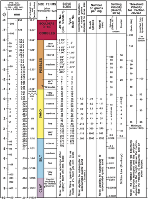
The cutoff between fine sand and course silt is about 62 micrometers.
Another nae for such material is “fugitive dust”, and it is nearly all mineral by composition and origin.
Who thinks a haboob is pollen?
Household dust on the other hand, is mostly organic, with a large amount of it things like dead skin cells, dust mite castings and feces, etc.
Assuming, assuming that the theory which says Saharan Dust is a massive source of nutrition for the Amazon Forest – there pretty well has to be clay in the dust
Because clay is (can be) extremely fertile soil and that comes from 2 connected parts.
That the Mica (Aluminium Silicate Hexahydrate) that clay is has huuuuge affinity for water.
All the useful plant nutrients are water soluble so when water penetrates into the mica sheets/lattice, it carries those little nuggets of goodness with with it
OK the water can dry out maybe but many of the metal ions will stay there in the mica lattice – like dehydrated or plastic wrapped food.
Then when the Saharan wind picks it up and takes it to Amazonia and the *rain* forest – the rain rehydrates it and releases the nutrition.
neat huh
So if it lands in the sea it rehydrates and contributes to sea level rise? sarc.
You have no idea what you are talking about.
-Everything is soluble in water to some degree, but some important micronutrients are often locked up in minerals that are not very soluble in water.
-The term “clay” denotes a particle size, not a particular mineral.
-The Amazon, like all tropical soils, have very deep horizons highly enriched in aluminum. In fact, tropical soil is the source of bauxite.
This is because of high leaching rates due to hundreds of inches of rain a year. Aluminum minerals are among the least soluble of minerals, so they remain and the soil becomes enriched in aluminum.
-Iron minerals also accumulate in oxisol horizons. Iron in Saharan dust is not in a soluble form. Ligands are required to make it bioavailable when, for example, it settles onto the ocean and fertilizes phytoplankton. Iron is a limiting nutrient over the open ocean basins.
Soils from arid regions are not leached, while tropical soils are highly leached.
Aridisols vs oxisols.
-Phosphates are nearly depleted from the soils in the Amazon, and it is this phosphate that is thought to be critically important when it is imported by wind from the Sahara to the Amazon.
-Hydration has nothing to do with why that dust is important in the Amazon.
As for iron, acidification and photochemical reactions are what makes the iron more bioavailable for phytoplankton.
Summary: Clay is a particle size, not a mineral type. There are places where some of the dust comes from, notably a dry lake bed in Chad, which is highly enriched in phosphate. That is what is thought to be important about Sahara dust transported to the Amazon. Some calcium and potassium too.
Phosphate is a limiting nutrient in Amazon tree growth, since almost all nutrients are locked up in plants, not in the soil as is the case where alfisols and aridisols are dominant
Facts are much neater that crap you made up that is wrong.
class.jpg (1345×690) (bp.blogspot.com)
“Dust” should be identified….the term is used in space too…”dust”. Get a microscope…run some tests…identify the “dust”…..it is elements and compounds but not named for some reason.
Properties of Saharan Dust
https://www.treehugger.com/what-is-saharan-dust-5116148
The circulation in the tropical Atlantic does not change, still the wind from the Sahara. Tropical storms may form in the Gulf of Mexico.

Is that a haiku?
Sorry.

Ah bright red shading to fiery orange and yellow – that means the temps are just above freezing, right?
Contour lines are so much more preferable to garish color charts….
Climatologically, the Gulf Of Mexico is a favored region for tropical development early and late in the season. Mainly from the remnants of old cold fronts. Not common in July and August.
July and early August rarely see any storms form in the Atlantic basin.
Particulate Matter < 10 µm
mass of atmospheric particles with a diameter less than 10 microns
https://earth.nullschool.net/#2023/08/11/1900Z/particulates/surface/level/overlay=pm10/orthographic=-13.07,23.06,844/loc=-18.604,22.477
Forecast
https://earth.nullschool.net/#2023/08/15/1900Z/particulates/surface/level/overlay=pm10/orthographic=-42.89,18.50,485
We can see that the dust captures some of the sun’s infrared radiation.
https://earth.nullschool.net/#current/wind/isobaric/850hPa/overlay=temp/orthographic=-18.52,23.81,844
Here in Fort Lauderdale you can sometimes see the Sahara dust as unusually ‘red’ sky near sunrise/9sunset.
Nice because we have so far had a quiet tropical storm season.
Same here in Fort Myers/Naples area. Lots of pretty sunrises and sunsets, but during the day the atmosphere looks sorta dull and almost smog like (we get no smog here ever). We usually get Saharan dust here but usually it’s in the late spring and early summer, but goes away when the typical pattern of afternoon and evening T-storms takes over.
Let’s flash back to this time last year. No idea that Ian was going to happen. No idea that so many lives would be destroyed with so many still not back to pre-Ian normalcy all these months later. No criticism, just saying you never now what is in store in the near future. So we stay prepared and hope for the best.
It is impossible to say anything about what is coming based on the number of early storms.
In 2004, Alex formed on July 31, the latest ever date at that point in time for a first named storm. It wound up one of the busiest, deadliest and most costly seasons on record at the time.
2005 was the worst on record on several metrics, including most ever names storms (since eclipsed, since they now name swirls of clouds lasting hours and way out over the north Atlantic).
The forecasts for what was to come was grim and alarmist.
Then came 2006, the quietest season on record, and it was followed by the longest major hurricane drought in US and Gulf of Mexico history.
Donna hit in what, 1960? 58 years later another one like it hit the same places with similar intensity.
Charley, 2004, Ian, 2022, same spot at landfall.
Best place it could have hit, arguably. Everything had been rebuilt to beefed up standards and codes.
Dade County is still waiting for another one like Andrew.
I think the last one to hit Fort Lauderdale and Palm Beach county extremely hard was almost a hundred years ago.
Of course, people over there think the remnants of Wilma was Godawful and Ian was a stiff breeze. Wilma did mess up a lot of really nice and very large ficus trees. And reminded people that terra cotta roof tiles are not heavy and are best not just left sitting loose on the roofs.
The truth is, by historical standards, a lot of the US has been very lucky for many many decades.
The early 20th century had powerful hurricanes hit places like New Jersey, New York, New England, so hard and so many times, when I was a kid the shore points up there were sparsely inhabited even in Summer and ghost towns in the Winter.
The lists of deadly floods caused by hurricanes in the northeast US is as long as my arm, but a couple years ago, most people seemed to think it was the first time Philly had EVER been flooded due to rains from a hurricane.
But I recall Agnes flooding so was bad, the Schuylkill River was all the way from 25th street in Center City almost to the edge of Franklin Feild at U of P.
Here is good advice for anyone who does not want to have to rebuild a home: Do not live near any water, anywhere. You may not get hit for decades in a row, or one may flood you a dozen times in the next 20 years.
Or just give everything away and wear a hairshirt: Democrats assure me that we can end bad weather if we are all in poverty and suffering terribly.
Really? I for one don’t believe any of it.
There used to be a dust monitor at the La Palma astronomical observatory, keeping track of the load of Saharan dust in the upper atmosphere, for obvious reasons. In the 25 odd years of its operation no anti-correlation or correlation was found with the hurricane frequency in the north Atlantic.
Me neither – what we read there is a description of the Emperor’s wardrobe
What exactly is a ‘deep feed’
In any case, that’s garbage as well.
A hurricane needs a thunderstorm, a big one coming from lots of heat in the surface water, NO wind shear above it and a steep lapse rate
Then it can crank itself up properly
The extra strong heat (not esp temperature) is near perfectly sourced by dirty sea-water = trapping solar energy in the top 20 or so metres of water rather than the top 100 metres
So, the Sputnik here is correct but for all the worng reasons.
Sputnik says the dust (potential muddy water) is all up in the sky and blowing away out to sea and *not* falling into the water near Cape Verde isles
THAT is why no hurricanes.
If the wind was calmer, dropping its load near the islands, *then* a hurricane might start.
The Sputnik picture is beautiful innit – it marks out the exact track almost all hurricanes take as they cross the pond. Innit perfect?
i.e Hurricanes follow their noses and their noses are sensitive to muddy water.
Why not, that’s where The Heat is – near the surface and concentrated in the top 20 or so metres.
Testable prediction: If when a hurricane does fire up, what we need is an aerial view of how muddy the water is ahead of it.
I say that the ‘cane will follow the muddiest part – instead of the random and ever expanding wandering walk that computers predict.
The ‘cane knows *exactly* where it’s headed = where the densest energy is.
if we can’t get those aerial shots of the water, look inland at where any heavy rain has fallen recently – the mud will be pouring out of the river(s) there and the hurricane will aim for that.
It’s here, we see it every day in Florida. Don’t need a monitor to see what my eyes see, and experience the effect it has on our weather here which is a very unusual pattern for mid to late summer in Florida.
Yes. For example here in Fort Lauderdale we usually have significant Tstorms forming over the Everglades and moving east ( cause their convective cloud bottoms are above the low afternoon onshore sea breeze pushing west to the Everglades.) Today was very ‘Sahara dusty’
—tannish hazy at midday with no sugar cane being burned south of Okeechobee, and zero Tstorms. Also less than usual normal clouds.
We also have been under a relentless high pressure dome over the Gulf for about 6 weeks now.
Also the axis of the subtropical high is further south than usual. That’s keeping African easterly waves further south in an unfavorable formation zone. The axis will move north as we approach the peak of the season and activity in the Main Development Region will increase.
That’s just the way it is.
https://earth.nullschool.net/#2023/08/12/0300Z/wind/isobaric/700hPa/orthographic=-45.36,22.43,485
That is an interesting graphic but wind cannot move clear across the Atlantic at anything approaching the apparent speed of that animation. What is actually being shown? Does evidence exists that it bears any relationship what so ever to reality?
I think the actual graphic is a snapshot in time. The wind arrows are animated to show the speed of the winds in each area. I think…
The graphic is real time. If you click on the wind stream it will give you the speed. I found ~52Km/hr or 30 Mph. 700 hPa is about 9,800ft.altitude.
Yeah, I never took the animation to be to scale at all.
National Geographic on Saharan dust flow across the Atlantic.
https://www.nationalgeographic.com/science/article/concerned-saharan-dust-plume-crucial-to-ecosystem
As a full time resident of south Florida, hit hard last year by Hurricane Ian, I can attest that the air here has been dominated by high altitude dust. It creates a certain dullness in the air during daytime, and contributes to fiery sunrises and sunsets. It’s also been an uncommonly dry summer for us – which is a typical occurrence when El Nino predominates as it is. It creates high pressure domes over the eastern half of the country particularly in the southern tier of states.
It gets rather hot (mid 90s) during the day, unless and until we get a rainstorm that immediately cools the air by 10-15 deg F. In our uncharacteristic summer so far, we are not seeing our typical pattern of afternoon and evening thundershowers, rather we either get no rain or we get our rainstorms in the morning, which is quite unusual for Florida.
Is this due to global warming? Of course not. It’s called “weather”, and this year the El Nino is shaping up to be a particularly warm one which appears to account for our unusual weather this summer to date.
Of course, things can change rather quickly. Last year we had well below normal tropical cyclone activity in the Atlantic through August and into early September. Anyone who’s lived in Florida a few decades or more like me knows one can never relax, because the worst storms typically don’t arrive until late September or even October. Well, sure as poop, Hurricane Ian arrived here on September 28 as the most damaging storm in Florida history, from which we are still struggling to recover. But Cat 4/5 hurricanes come ashore somewhere here in Florida every few years, and that’s been documented ever since the first Spanish conquistadors arrive here more than 500 years ago (even Columbus suffered from at least two major hurricanes during his several years in Cuba).
Good information.
As the attached image shows, the dust is actually originating in Asia, although some is probably picked up from the Sahara.
If it is inhibiting hurricanes, it may do so for quite a while.
That is a component I had not seen. But, seen — it makes sense. ?auto=webp&s=fea40fa19c8722817710fbd4f47e3469295079ad
The deserts under the red color are identified here:
Reddit –
Some years ago, there was an article, I think here, about how hurricanes or more accurately, their precursors, could be tracked across Asia and then North Africa and the Atlantic. I didn’t take time to look for it tonight. But the concept does not surprise me.
Alarmists: We always have to have an emergency backup excuse in case our predictions don’t pan out. Just so it doesn’t conflict with the “climate change” narrative.
So … “Climate Change/CAGW” will cause more and more intense hurricanes.”
But not this year because weather-caused dust will prevent and/or hinder it from happening?
If it wasn’t for the weather, everybody would see how catastrophic climate change is!
Gunga Din, your quote reminded me of the prognostication that climate change/CACW is also supposed to increase the frequency and strength of El Nino events in the tropical Pacific. The two prognostications are incompatible, because El Nino events suppress hurricane formation in the tropical North Atlantic by basically chopping the tops off the hurricanes.
Regards,
Bob
“Whatever gets a Headline” seems to what drives “Climate Science” reporting today.
PS Thanks for your past posts and books. I learned a lot. (Also forgotten a lot, but that’s on my end.)
NHC in Miami says the lack of predicted 2023 tropical storms to date is from high wind shear caused by emerging El Niño.
Agreed, it is one of the reasons why Hurricanes have shown no increase in frequency or strength over the recent decades. An increase in El Nino’s since the 1980’s has been responsible for this.
“El Niño produces stronger westerly wind at upper levels of the atmosphere across the tropical Atlantic than in normal non-El Niño seasons. This increases the total vertical wind shear, basically shearing the tops from developing storms before a healthy circulation can form.”
https://www.weather.gov/jan/el_nino_and_la_nina
It looks like a rather colorful smiling manatee heading for the Caribbean. 😉
No, it’s a sperm whale. If you zoom in you can see Pinocchio waving just below the “eye”. 😎
Story tip – EV truck no good – ‘BIGGEST SCAM’: Man’s electric truck purchase turns into nightmare – YouTube
The idiot should have researched BEFORE buying. Tow capability minimal. Haul capability minimal. Range limited. He found out the hard way at a cost of $130k.
If he wanted to virtue signal, there is a nifty hybrid F150 that even provides four AC power outlets in the bed (for power tools), with the hybrid engine running as the ‘generator’.
The hybrid is definitely the way to go.
It would come in handy in a power outage, too.
The hybrid bat will need replacement one day….maybe end the life of vehicle due to cost….repairs more complex and expensive….new vehicles are becoming more and more electronic and plastic….not good for longevity.
We own a MY 2007 Ford hybrid Escape AWD with class 1 tow hitch (tow motorcycles). 14 years on, the traction battery is still good at ~90,000 miles. Used as taxis in NYC, such hybrid Escapes have reached 300,000 miles.
Love our 14 Avalon Hybrid! 215k and only maintenance have been oil changes and tires – regen brakes are still solid. Gets 35-40 mpg, depending on how often my foot gets impatient.
I love the characterisation of the EV as a ‘patrician’s vehicle. The old Roman elite making a comeback? Is that how backward the eco mindset is?
“Once a pocket a Saharan Dust begins moving westward over the Atlantic, it is relatively easy to track using infrared satellite products.”
Satellites are no good for measuring anything, you have to use the surface for better observations. (sarc/off)
As every alarmist wrongly claims regarding global temperatures.
Sahara dust must be a new phenomena.
Apologies in advance, couldn’t resist:
https://m.youtube.com/watch?v=tH2w6Oxx0kQ
Everyone knows that hurricanes are caused by butterflies in west Africa flapping their wings and causing a circular air motion that develops into a low pressure system off the coast of Africa.
The peak of the H. season is Sept. 10th
Search. My last attempt at a web link (world deserts) looks trashy.
Abstract
The productivity of the Amazon rainforest is constrained by the availability of nutrients, in particular phosphorus (P). Deposition of long-range transported African dust is recognized as a potentially important but poorly quantified source of phosphorus. This study provides a first multiyear satellite-based estimate of dust deposition into the Amazon Basin using three-dimensional (3-D) aerosol measurements over 2007–2013 from the Cloud-Aerosol Lidar with Orthogonal Polarization (CALIOP). The 7 year average of dust deposition into the Amazon Basin is estimated to be 28 (8–48) Tg a−1 or 29 (8–50) kg ha−1 a−1. The dust deposition shows significant interannual variation that is negatively correlated with the prior-year rainfall in the Sahel. The CALIOP-based multiyear mean estimate of dust deposition matches better with estimates from in situ measurements and model simulations than a previous satellite-based estimate does. The closer agreement benefits from a more realistic geographic definition of the Amazon Basin and inclusion of meridional dust transport calculation in addition to the 3-D nature of CALIOP aerosol measurements. The imported dust could provide about 0.022 (0.006–0.037) Tg P of phosphorus per year, equivalent to 23 (7–39) g P ha−1 a−1 to fertilize the Amazon rainforest. This out-of-basin phosphorus input is comparable to the hydrological loss of phosphorus from the basin, suggesting an important role of African dust in preventing phosphorus depletion on timescales of decades to centuries.
https://agupubs.onlinelibrary.wiley.com/doi/full/10.1002/2015GL063040
This trans-continental journey of dust is important because of what is in the dust, Yu said. Specifically the dust picked up from the Bodélé Depression in Chad, an ancient lake bed where rock minerals composed of dead microorganisms are loaded with phosphorus. Phosphorus is an essential nutrient for plant proteins and growth, which the Amazon rain forest depends on in order to flourish.
Nutrients – the same ones found in commercial fertilizers – are in short supply in Amazonian soils. Instead they are locked up in the plants themselves. Fallen, decomposing leaves and organic matter provide the majority of nutrients, which are rapidly absorbed by plants and trees after entering the soil. But some nutrients, including phosphorus, are washed away by rainfall into streams and rivers, draining from the Amazon basin like a slowly leaking bathtub.
The phosphorus that reaches Amazon soils from Saharan dust, an estimated 22,000 tons per year, is about the same amount as that lost from rain and flooding, Yu said. The finding is part of a bigger research effort to understand the role of dust and aerosols in the environment and on local and global climate.
https://www.nasa.gov/content/goddard/nasa-satellite-reveals-how-much-saharan-dust-feeds-amazon-s-plants
Is it raining in Chad? Yes, it rains.
https://pl.sat24.com/pl/td/visual
Sahara dust is also a contributor to red tide blooms in the Gulf of Mexico.
amazing – I read some time ago that the Sahara dust was also a big factor in causing the NA glaciers to retreat – man is so utterly irrelevant to changes in the climate
This is interesting, and not just a “idea”. When we lived in the Caribbean (for more than a decade), strong Saharan dust events would result in the nice white decks of our sailboat getting coated with fine red powder — just enough to make the white not-so-white. Wiping the deck with a clean rag would reveal the red Saharan dust that had settled overnight.