Australia’s ABC News and Marty McCarthy not only jumps the shark, but makes a mockery of science reporting.
Ross Hyland writes to Climate Depot (which was forwarded to me for analysis) about a claim about climate change on a tiny volcanic island called Heard Island, not far from Antarctica.
This article in Australia’s ABC has this to say about the McDonald Islands, which are actively volcanic, with Heard island having a very active volcano:
From the ABC article:
Even if you could get to Australia’s most remote island, chances are you still wouldn’t quite see it.
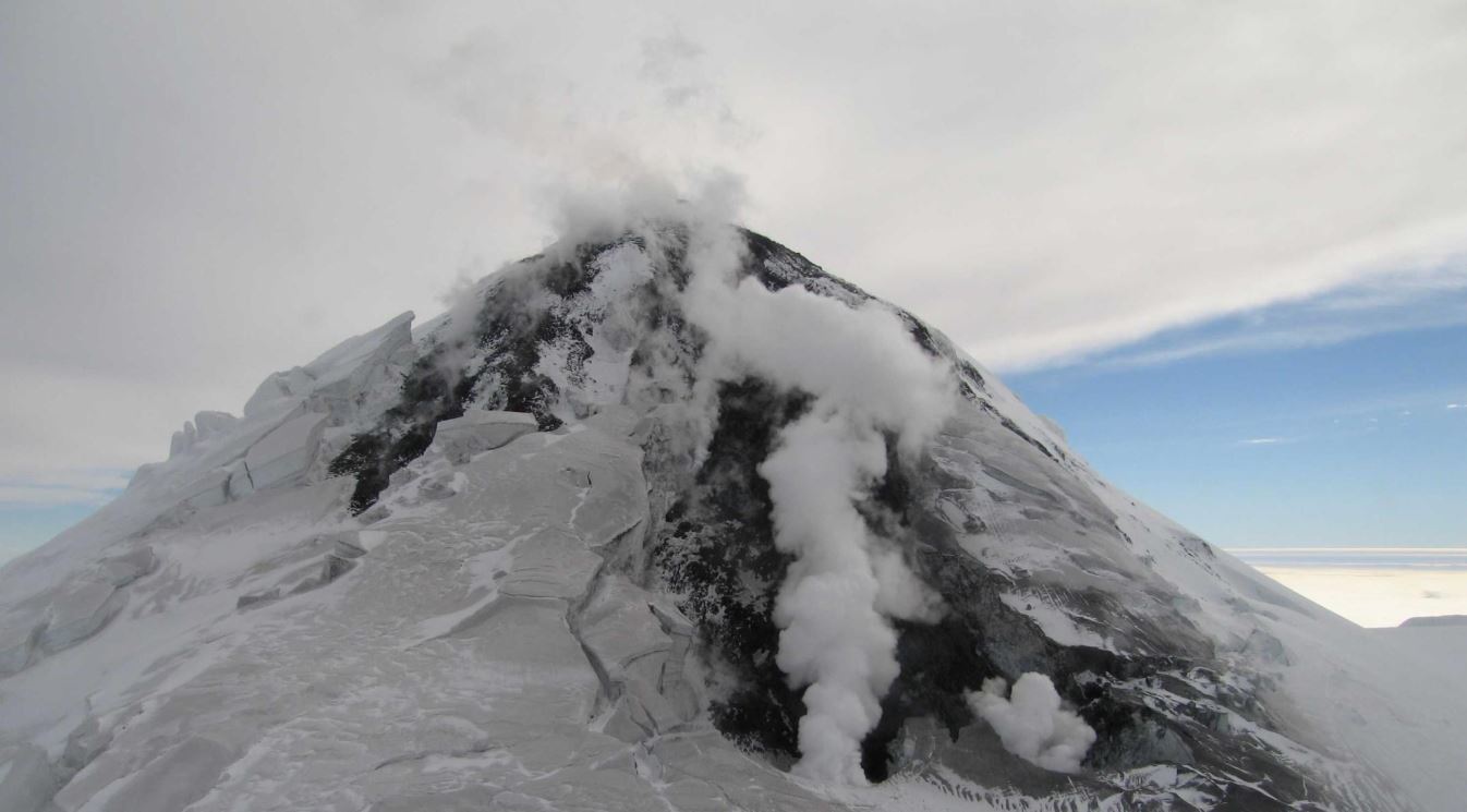
The little-known landmass, Heard Island, hides in dense cloud for around 360 days a year.
The rare few who do reach this distant wonder are more likely to hear the gurgle of molten rock bubbling up through the island’s violent core.
The active volcano on Heard Island, known as Big Ben, is adorned with vast glaciers stretching to the crashing waves of the ocean far below.
With cloud cover 360 days a year, that’s a far greater climate forcing than the “greenhouse effect” could ever be on the island. But, then there’s the volcano to consider.
Here’s the claim in the ABC article, bold mine:
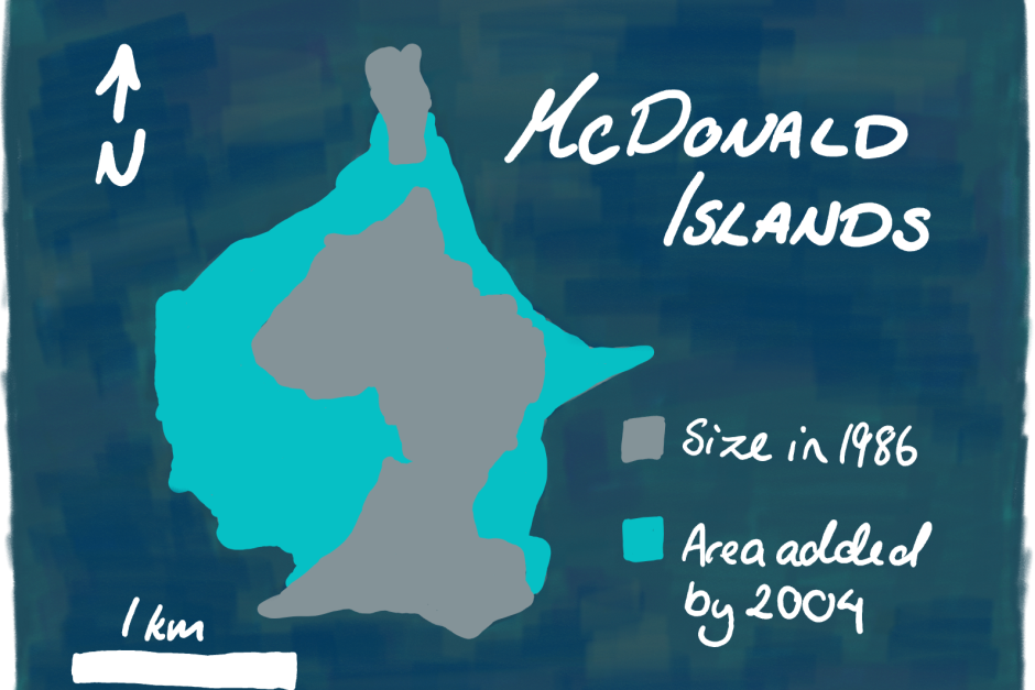
Tiny Heard Island is technically part of Australia and has our tallest mountain ( little known fact). It sits on a complex array of deep rooted volcanic activity (about halfway to the Earth’s core). It’s a violent, dangerous place to visit. In 1996-97 the island doubled in size due to a huge eruption.
A land of ‘fire and ice” it has flowing lava and flowing glaciers.
Amazingly, climate change scientists are claiming this hellish place as a sort of sentinel or “canary in a cage” for their cause. They claim to know that the average temperature on Heard Island has increased 1 degree C in summer and 0.8 degree C in winter. They study the movement of glaciers (presumably as they flow over lava fields) to see what man’s CO2 contribution has done to them.
Umm, right. Glaciers flowing over newly created lava fields, what could possibly happen there? But, let’s blame CO2 and the greenhouse effect and forget about that 360 days of cloud cover!
Also amazingly, in their rush to pin it on the universal bogeyman known as climate change, they don’t seem to connect the dots between active volcanism and local temperature increases, or glacier retreat. Without even considering glaciers flowing over new hot lava fields as a contribution to retreat, with the island doubling in size and character due to eruptions, something as simple as a terrain change can affect local wind patterns and thus precipitation deposition on glaciers, and they then begin to sublimate. Al Gore made the same dumb mistake by claiming Mount Kilimanjaro’s glacier loss was due to climate change, when in fact it was a change in local terrain which affected precipitation patterns on the mountain, and the glaciers sublimated away.
Also oblivious is the Australian Government in their discussion of the issue on the web page they established for the island.
“Meteorological records at Heard Island are incomplete, but there is considerable evidence that the local climate is changing. Observations at Atlas Cove indicate an increase in average annual air temperature of almost 1°C between the periods 1948–1954 and 1997–2001. This mirrors similar changes interpreted from observations at nearby Îles Kerguelen and elsewhere in the southern Indian Ocean.”
Gosh. So let me get this straight. The [McDonald Island Group] doubles in size in 1997 due to a major volcanic eruption, [and Heard island has ongoing eruptions] which necessarily put out lots and lots of hot lava that can take years, even decades to cool:
Thick stacks of lava flows (30 m or 100 ft thick) can take years to cool completely. An extreme example is a lava flow that was erupted in 1959 and partly filled a pit crater (Kilauea Iki). The “ponded” flow was about 85 meters thick (about 280 ft thick). It was drilled in 1988, and there was still some mushy, not-quite-solid stuff down near the bottom, 29 years after it erupted!
Source: http://volcano.oregonstate.edu/how-long-does-it-take-lava-cool
…and using a small fragment of climate weather data, these folks don’t think twice about it affecting local air temperature? What an abject failure of science and science reporting.
I’m guessing the volcanologists who study Heard Island put a meteorological station on the island to monitor what’s going on…and from that we get the 1997-2001 dataset (which is not public AFAIK). The volcanologists aren’t tracking climate change, but are more interested in winds and temperature for plume predictions and other terrestrial purposes. But like weather stations at airports, designed only to monitoring runway conditions, the data gets co-opted for climate pronouncements by the media that can’t tell the difference between good weather data and weather data not fit for climate purpose.
What is even more ridiculous in naming this island a “canary for climate change” is using two short data periods of 6 years ending in 1954 and 4 years ending in 2001 to deduce climate change on an active volcanic island. That is patently absurd.
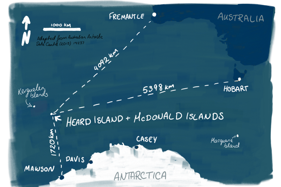
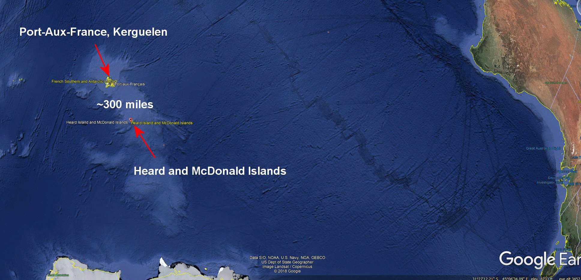
This nearby island they mention in the ABC article, about 300 miles away from Heard Island, Kereguelen, has a GHCN climate station at Port Aux-France:
It also has incomplete climate records, but far more complete that Heard Island. The data according to NASA GISS:
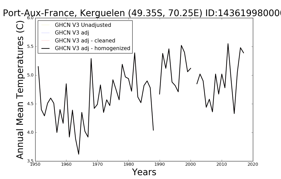
Source: https://data.giss.nasa.gov/cgi-bin/gistemp/stdata_show.cgi?id=143619980000&dt=1&ds=5
Data here: https://data.giss.nasa.gov/tmp/gistemp/STATIONS/tmp_143619980000_5_0_1/station.txt
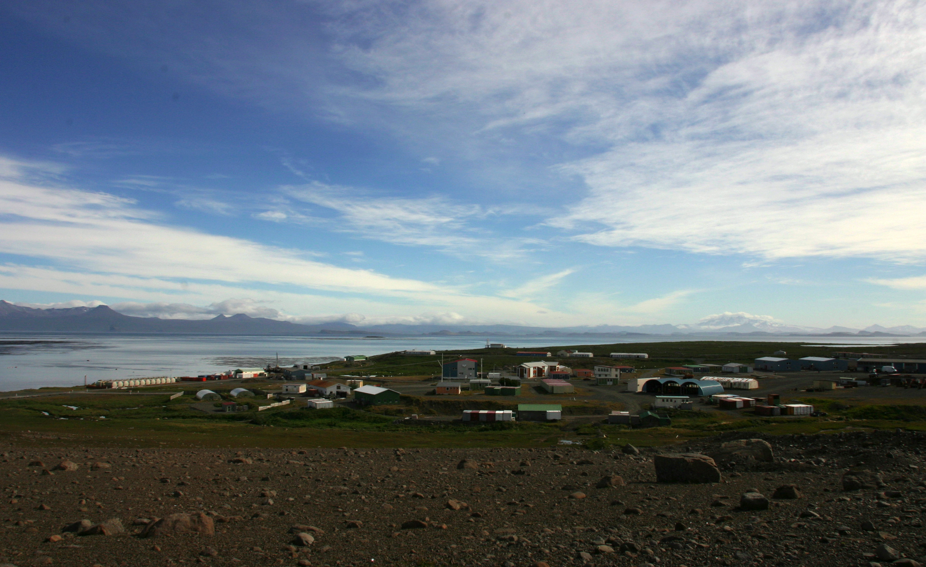
I don’t see any big climate change there. There’s some trend from about 1965 to 1987 then a break, followed by another in what appears to be a relative flat period of normal temperature fluctuations. I’m guessing a station move occurred, so who knows if that data even is valid? For all we know,it might be right next to the diesel generator that powers the village. Note the bank of fuel tanks in the left hand side of this image from the Wikipedia article:
What’s certain is that pocket of humanity needs heat to stay alive in the winter, and waste heat UHI in polar climate outposts/towns is a real thing, which is documented in Barrow Alaska, not that dissimilar from Port Aux-France. For all we know, that up-slope of temperature from about 1965 to 1987 may have been due to expansion of the community using more fuel and generating more waste heat. You just can’t be sure because you can’t disentangle it from the data.
Plus there are studies that show shifts in ocean currents around Antarctica have been responsible for what some rush to blame on “climate change”. But, telling us an active volcanic islands brief fragments of temperature records represent “climate change”, especially after a massive eruption doubled the size of the island with hot lava that can take years to cool is an epic distortion of science.
ABC should retract this story, and admonish the writer Marty McCarthy for failure to check basic facts. At the very least, put a note about the claim about this island being a canary for climate change as being unsupportable and absurd in the story.
UPDATE: I’ve clarified and added [in brackets] my language about the McDonald Island Group and Heard island volcanic eruptions.
I have too much time on my hands. Articles like this at WUWT lead me to do a deep dive into obscure subjects, like Australian External Territories. If the wiki pages can be believed (they appear pretty straightforward), the Heard Island and McDonald Islands (HIMI) External Territory is no different than the Australian Antarctic Territory (AAT). In which case, the article’s claim that the volcano on Heard Island, Mawson Peak, is the highest point in Australia is also incorrect. That honour would belong to Mt. McClintock in the AAT. If there are any geo-political experts from Oz reading this, feel free to jump in and set me straight if the above is oversimplified.
An oddly placed island at 53S latitude with an active volcano and 41 glaciers just seems like a poor choice to obtain a meaningful “canary” signal. Lots of neat geology at work, though.
Windsong — if you have so much time on your hands perhaps you should try reading the actual article. It clear states that Big Ben “at a soaring 2,745 metres, it is 517m taller than Mount Kosciuszko, giving it the little-known title of the tallest mountain in Australian-owned territory excluding Antarctica.” So the article is correct but you just need to read it.
Percy, I stand corrected. The hotlink for the ABC article does not work for me. I saw the height reference in the boxed portion of the quoted article. Once I slowly reread everything above, the caption on the photo covers that reference to height.
Slow is smooth, smooth is fast.
“Also amazingly, in their rush to pin it on the universal bogeyman known as climate change, they don’t seem to connect the dots between active volcanism and local temperature increases, or glacier retreat. Without even considering glaciers flowing over new hot lava fields as a contribution to retreat, with the island doubling in size and character due to eruptions, something as simple as a terrain change can affect local wind patterns and thus precipitation deposition on glaciers, and they then begin to sublimate. Al Gore made the same dumb mistake by claiming Mount Kilimanjaro’s glacier loss was due to climate change, when in fact it was a change in local terrain which affected precipitation patterns on the mountain, and the glaciers sublimated away.”
An oft repeated pattern in climate alarms about Antarctica
https://tambonthongchai.com/2018/06/09/history-of-the-global-warming-scare-chapter-5-2000-2005/
oops
here is the correct link
https://tambonthongchai.com/2018/06/15/history-of-the-global-warming-scare-chapter-6-2005-2010/
” something as simple as a terrain change ”
Mt. Rainier in Washington State has had flows out over glacial ice.
The results are not exactly simple, but the terrain sure is interesting.
” … ABC should retract this story, and admonish the writer Marty McCarthy for failure to check basic facts. …”
—
He’ll get a science journalism award for that. The more perverse, inaccurate and lazy a report is the more ABC likes it.
Ah, but CO2 does EVERYthing! https://www.youtube.com/watch?v=9vdl3TRxv0c
[off-topic]
“For all we know,it might be right next to the diesel generator that powers the village. Note the bank of fuel tanks in the left hand side of this image from the Wikipedia article:”
This site gives rather precise coordinates 49°21’06″S, lon : 70°14’36″E. On Google Maps it appears as an isolated location, 3-4 km from the settlement, and has what look like reasonably sited equipment.
Sorry, wrong link. I meant to give this one which seems to be Kerguelen Meteo. The other link is interesting, with photo, but is a atmospheric gas monitoring station, and doesn’t seem to be the same site.
Looks more like 60m at most ?
An island that small set in the roaring forties of the southern ocean has its climate tempered/tied to the SST of the ocean immediately upwind of said roaring forties.
There will be next to zero GHE warming subjected to thermometers there (other than that transferred to the ocean surface).
There needs to be radiation conditions on a regular basis (clear skies, light winds overnight) for that to make a sig contribution to any warming.
The upwind sea-surface temp will entirely swamp that due the wind strength/moisture content.
The average wind strength there is ….
“The winds at Heard Island are predominantly westerly and persistently strong. At Atlas Cove, monthly average wind speeds range between around 26 to 33.5 kilometres per hour. A maximum daily wind gust of greater than 180 kilometres per hour has been recorded on several occasions.”
http://heardisland.antarctica.gov.au/about/climate-and-weather
Atlas Cove also seems particularly exposed to the prevailing W’ly winds, whereas the sheltering effect of being on the east side is seem here ….
“Air temperatures at Spit Bay, only 25 km to the east can be remarkably different, with monthly mean temperatures being as much as 1.3°C higher.”
I think their canary has flown the coop, and is now somewhere over the rainbow.
“…The rare few who do reach this distant wonder are more likely to hear the gurgle of molten rock bubbling up through the island’s violent core…”
Bubbling up thrugh the core?
What a time to be alive…
This was not “a scientific and reporting failure”.
It was scientific fraud and socialist journalist propaganda.
“Meteorological records at Heard Island are incomplete…”
Somewhat of an understatement.
Atlas Cove weather station operated Feb 1948 to Dec 1954 with a few odd observations after that
The Spit weather station operated April 1992 to March 1993
To make any sort of claim about weather trends/changing climate based on the utterly sketchy record from Heard Island is utterly ludicrous.
There’s a more complete weather record from Australia’s sub-Antarctic weather station at Macquarie Island which is just a hop, a skip and a jump [and 5000km] away