Brief Note by Kip Hansen
 Phillip Klotzbach and Michael Bell, who continue the invaluable work of the late William M. Gray, at the Department of Atmospheric Science of Colorado State University have issued their latest updated forecast for the Atlantic Hurricane season of 2018 which begins 1 June. The short-form summary reads:
EXTENDED RANGE FORECAST OF ATLANTIC SEASONAL HURRICANE ACTIVITY AND LANDFALL STRIKE PROBABILITY FOR 2018
We have decreased our forecast and now believe that 2018 will have approximately average activity. While we still do not anticipate a significant El Niño during the 2018 Atlantic hurricane season, most of the North Atlantic has continued to anomalously cool over the past two months. The eastern and central tropical Atlantic is cooler than normal at present. We anticipate a near-average probability for major hurricanes making landfall along the United States coastline and in the Caribbean. As is the case with all hurricane seasons, coastal residents are reminded that it only takes one hurricane making landfall to make it an active season for them. They should prepare the same for every season, regardless of how much activity is predicted.
(as of 31 May 2018)
By Philip J. Klotzbach and Michael M. Bell
The full 35 page report is available in .pdf format here.
# # # # #
Addendum: (1 June 2018: 0900 ET) The forecast in numbers.

# # # # #
Addendum #2: 1 June 2018: 0920 ET
Dr. Judith Curry’s CFAN issues this short form prediction via a tweet:

# # # # #
Addendum #3: 1 June 2018: 1140 ET Joe Bastardi’s WeatherBell prediction

# # # # #
Addendum #4: 1 June 2018, 1200 ET
XL Catlin, the Barcelona Supercomputing Center and Colorado State University offer this summary of predictions from various universities and private companies. I have modified it for better viewing, but suggest clicking for a view of the original page:

# # # # #
Is forecasting kind of like gambling where you just hope for good luck on the numbers you pick or is there any actual skill in this crapshoot?
astonerii ==> Read the report and see what it is based on.
Some skill. For example the number and strength of Atlantic hurricanes is known to be correlated with ENSO and ENSO is moderately predictable.
Beyond that, who knows? Long range weather forecasting has a fairly dismal record, but maybe tropical cyclones are easier. Or maybe it really is different this time.
Is forecasting kind of like gambling…yes, only you are allowed to change your bet every month
and seemingly the change in bet doesn’t cost most of the gamblers anything… not even reputation, usually.
I have a prediction that I will be happy to take any amount of money on – I predict that there will be 12 named storms this year, plus or minus 10. You can count on it!!!
@wws, exactly. See my comments below on four take-aways
I would put more faith in Judith or Joe Bastardi’s forecasts than a government service. They put money and reputation on the line. Government flunkies are more likely to put at least a smidgen of politics in their forecast, plus they aren’t worried about failure costing them anything.
Yes, but when your horse comes in last, you can still pretend you won.
If the tropical Atlantic is cooler than normal, why do they expect an “approximately normal” hurricane season?
Tom, obviously it’s the CO2 😉
Actually it is the water vapor.
Four questions to ask your warmist friends.
What are the photon absorption bands of CO2?
What are the photon absorption bands of water vapor?
What is the overlap?
What does it mean?
I think it is because OTOH La Niña years tend to have above normal activity.
Long time Gulf Coast resident here – hurricanes depend on more than just sea temperatures to form and make landfall, although sea temperature is a strong factor in storm formation.
Of course the “named” season is getting off to a great start. They burned one of the names on a system that never became tropical. Are we now naming any puddle of thunderstorms to drive our “named storm” numbers up? Granted, it produced a very large amount of rain, but due to the complex atmospheric setup, it never reached the characteristics of a “tropical” system but remained a “sub-tropical storm” throughout its existence. At this rate we may be in the double letter storm category by July.
The UK Met Office started playing the “Naming Game” a couple of winters ago at about the same time that everything stronger than Force 4 or snow more than an inch deep needed one of its colour-coded warnings.
The best comment came from one of the local newspapers in northern Scotland which ran the headline “Storm Abigail now upgraded to ‘normal Hebridean weather’”. I don’t think the Met Office were amused! Pity really, because everyone else was!
Possibly driven by the insurance industry – as soon as we have a named storm, thousands of boaters have a large deductible applied to any claim.
Anyone really care what the annual hurricane forecasts ever says? Anyone remember any forecast from years ago?
Remember the hippy dippy weatherman?
Tomorrow’s forecast will be mostly light after sunrise with possible clouds to be followed hours later by darkness.
I’ll predict the 2018 hurricane forecast will be very similar to any other average year in the last 30 years.
In fact, EVERY year for the next 30 years will probably be indistinguishable from average. If not, then don’t hold me responsible if a couple years are worse than average.
Everyone knows that the main point of US TV weather forecasts is an excuse to get an attractive woman on the screen. My main objection is the relative lack of employment opportunities afforded to men. Maybe that’s why they invented the climate game.
If you live in a hurricane prone area you pay attention. Not so much to the numbers but to see if they predict a greater deviation than normal, then it becomes of much greater interest. I would say most of us stay vigilant regardless and prepare for the worst while hoping for the best remembering that it only takes on direct hit to ruin your life.
bw ==> I spent 12 years living on our sailboat in the Northern Caribbean — we were always very concerned about the forecast –it meant staying and toughing it out there or running up to a safer harbor in North Carolina.
Insurers care and municipalities and governments of the islands.
Bill Gray and his team have the best record on these predictions.
Yup. Always looking at long-range and short-range forecasts. Always prepared. Erin, Opal, Ivan, Dennis, Katrina……
.. my latest attempt to post a comment on the new cloud-migrated version of WUWT
Keep trying, you’ll get through eventually.
I will summarize it:
NOAA says:
Named storms: 10 to 16
Hurricanes: 5 to 6
Major hurricanes: 1 to 4
I supposed that Alberto does not count because he arrived ahead of schedule. Nonetheless, he brought rain, cooler air, and a few really red sunrises and has now dissipated into nothing. Should be 60s tomorrow in my kingdom.
I checked the Hudson’s Bay area, too. The MODIS satellite images show the meltback is a little further north, but not by much and the white stuff (SNOW????) is squatting firmly on the terrain from the southern end of the Bay. Also, the snow pack in WA, OR, and CA, as well as CO, is still showing up with a depth of at least 60 inches on the Doppler weather radar, and I saw a spate of active snow in the Rockies on the radar this morning.
Now, how this snow will affect the weather down here in my kingdom is something that remains to be seen, but if it’s a nice, cool, rainy summer with plenty of sunny days for the dragonflies to be out chasing mosquitoes, that’s fine with me.
Thank you for your kind attention. Try the grilled cheese and be sure you tip the waitress before you leave.
I think Alberto will be subject to re-analysis before we know. ACE will be negligible, if at all, regardless.
Sara ==> Where are you? (and do you have coconut cream pie?)
35 miles north of Chicago, 5 or so miles west of Lake Michigan.
No, don’t have coconut cream pie but I can get it. Pumpkin – yes. Pumpkin pie with whipped cream, hot cider with lemon slices, and a nice, crisp fall day after a hike through the forest preserve with a camera.
Sara ==> Sounds delicious — thanks for reading here.
The cool central Atlantic and into the Caribbean argues for a lower Accumulated Cyclonic Energy (ACE) potential. The pool of warmth along the upper Atlantic coast of the US indicates storms that get there may have enough energy available to spin up ‘close in’. Overall, it looks like a lower than normal hurricane season awaits.
Courtesy of Phillip’s tweets! Seems the colder than usual tropical Atlantic is making forecasts move. Dont’ see CFAN on this list however? They have done pretty well and have consistently been on this side of the hurricane forecast equation right out of the box.
http://www.bsc.es/seasonalhurricanepredictions
CFAN predicts a below normal 2018 Atlantic hurricane season
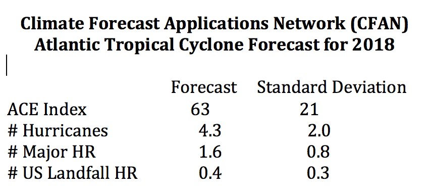
CFAN was dead on target last year, except for predicting three major landfalls in the US rather than two.
The CFAN prediction is:
Note: fewer hurricanes, a lot lower ACE.
PS: No images in comments, apparently, added to post above.
Kip
How come no one predicts East and West Pacific activity.
Regards
Testing…
I suspect it will be below average but that doesn’t get the US in the clear since the most conducive waters for TS development and strengthening are the western Caribbean and the warmer than normal waters off the eastern seaboard. The MDR looks dead right now, cold and dusty and I suspect SSTs will be cooler than average there for much of the season. Waters in some of the El Nino zones are starting to warm and trades are shifting a bit.
But what the heck do I know except that I might as well make my guess because it’s probably as good as any. I will bet NOAA is too high this year even though they have the advantage of tilting the table in deciding to name storms that would have never been named 5-10 years ago and by inflating the windspeed of storms as they clearly did last year with Irma.
Joe Bastardi’s yer man
Cooler than “normal” or cooler than average?
If the former, who decided what is normal and how?
Thank you, Phoenix! “Normal” is the most misused word in the whole weather lexicon. Weather doesn’t have norms, only averages. A norm is what should be, verified by observation or experiment. 98.6 F is normal human body temperature; large deviations from that norm can kill people. Normal eyesight is 20/20; deviations can severely limit activity. Playwright George Bernard Shaw was urged by friends to visit an oculist (=optometrist) for an eye test. The doctor told GBS that his eyesight was normal, and assured him, “That condition is very rare.” Normal eyesight was–and remains–established by observation and experimentation.
Weather doesn’t have norms; it has observable conditions, which can sometimes be expressed as long-term averages (LTA’s). Here in Virginia, rainfall averages roughly a tenth of an inch per day. Of course, some days have no rain at all: Are such days abnormal? Other days have an inch or more of rain; same question. This past May, here in Mechanicsville, averaged 71.2 degrees F, which is about 4.6 degrees above the LTA. Is that abnormal? It’s a tad unusual; but it’s happened before, and it merely seems to be the inevitable swing back from March (about 8 degrees below LTA) and April (about five degrees below LTA). Thus, May was about 18 degrees warmer than April, which is unusual, but by no means unheard of. May can get quite hot here, and elsewhere; my college graduation was around Memorial Day in 1964, and the temperature reached over 100 degrees in Indianapolis as we drove home from Bloomington. No one then said such a day was abnormal; they said, “Yikes, it’s hot!”
And partly due to the well known Trump Effect.
Well, I’ve got my generator tuned up. Maybe I’ll fill some gas cans too.
I wish my boss was happy with a data point where one standard deviation uncertainty was 50% of the value.
Ok, wait for it, someone will say it assuredly!
“this is exactly what the climate models predicted!”
On a personal note, I’ll be on the outer Banks NC in two weeks, so this reduction is welcomed.
Peter ==> Good luck in NC. My wife and I sat out Irene in August 2011 on our sailboat just inland from Beaufort — it was quite a ride.
Our forecast issued May 7th fyi. First forecast had a normal ace, second below. Biggest problem this year will be threat of in close features over very warm water out of MDR. Prime ace analogs are 2002,2006,2009,2014. Alot of ace points can be scored with slow moving features in very warm SST north of tropics, which had me skew ACE idea a bit higher than pure analog, ECMWF SLP pattern with Positives over NE Canada suggest east coast has to be wary of threats that develop in close, though bulk of systems should remain out at sea. In any case if you have nothing better to do, ours has been out for nearly a month ( the update of the first forecast that comes out in March
https://www.weatherbell.com/may-hurricane-season-update
Joe ==> Have added your prediction to the main essay. Cheers, KH
Thanks Kip!
Notice my previous comment did not get on, Anyway here is our May 7 forecast
https://www.weatherbell.com/may-hurricane-season-update
Thanks Kip. CFAN is getting better than NHC at near term track forecasting—it is their business proposition. We decided to shelter in place with Irma four days before it hit, because their track was consistently west and everyone elses continued shifting from east to west. Given the evacuation mess from Miami, that proved a good call. We never even lost power.
Our new neightbor Charles the Moderator has my gobag prescription and is stocking it this week.
What strikes me about this report is (the actual pdf):
a. These are very good forecasters who make their money by being right — customers pay for results.
b. The hindcast is only good during the pre-1998 era. The later era deviates wildly from the actual activity. This puzzles me. Was the hindcast predicated by only pre-1998 activity?
c. The error estimate (which is wonderful transparency) is only at the 1 SD level, and ⅓ to ½ of the estimated forecast. I wonder if, at the 2-3 SD level the error would swallow the estimate.
d. Since this is the best we can do for the next season’s major weather activity, no one should take any notice of long-term, multi-decade predictions.
Updated: There have been 4 updates to the original post since this morning — adding in details and predictions from other major organizations. – kh
Get used to cooling in the North Atlantic and some cooling in the South Atlantic also.
Forecasts in El Nino years are easy, low because upper level winds tear the storms apart before they can amount to much. Otherwise the process is too chaotic to predict more than a few weeks in advance. The cliche’ chaos example is that that a butterfly in one continent can result in a hurricane in another continent. Last year was bad because of a combination of calm upper level winds in the tropics and cool high pressure in the NE US.
Not really. 1951 1969 2004. El Niño years big acevyears. In addition in close feedback storms big problems though ace overall lower in most years