News Analysis by Kip Hansen
 Jean Lafitte, Louisiana, is situated at two feet above sea level and about ten miles south of New Orleans. It has the misfortune to sit just outside of the protective system dykes and levees that keep New Orleans from flooding.
John Schwartz, at the New York Times, writes about “the ecological crisis facing Louisiana’s vanishing coast” in “Left to Louisiana’s Tides, a Village Fights for Time”, a long narrative magazine piece relating the struggles of this small town to save itself from what appears to be the ultimate fate of much of the Mississippi Delta:
“Saltwater intrusion, the result of subsidence, sea-level rise and erosion, has killed off the live oaks and bald cypress. Stands of roseau cane and native grasses have been reduced to brown pulp by feral hogs, orange-fanged nutria and a voracious aphid-like invader from Asia. A relentless succession of hurricanes and tropical storms — three last season alone — has accelerated the decay. In all, more than 2,000 square miles, an expanse larger than the state of Delaware, have disappeared since 1932.”
“….Just two miles north is the jagged tip of a fortress-like levee, a primary line of defense for greater New Orleans, whose skyline looms in the distance. Everything south of that 14-foot wall of demarcation, including the gritty little town of Jean Lafitte, has effectively been left to the tides.”
The Times’ piece lays out the emotionally rending story of this small bayou fishing village’s political attempts to somehow, anyhow, get itself included inside that 14-foot tall fortress-like system of levees that protect New Orleans from the rise and fall of the tides, storm surges and seasonal floods that relentlessly eat away at the coasts along the Gulf of Mexico.

Schwartz asks:
“Jean Lafitte may be just a pinprick on the map, but it is also a harbinger of an uncertain future. As climate change contributes to rising sea levels, threatening to submerge land from Miami to Bangladesh, the question for Lafitte, as for many coastal areas across the globe, is less whether it will succumb than when — and to what degree scarce public resources should be invested in artificially extending its life.”
Isn’t it a shame, what the river has done to this poor crackers’ land?
What has happened here? Where has all that land gone, and why? According to the US Geological Survey:
“The swamps and marshes of coastal Louisiana are among the Nation’s most fragile and valuable wetlands, vital not only to recreational and agricultural interests but also the State’s more than $1 billion per year seafood industry. The staggering annual losses of wetlands in Louisiana are caused by human activity as well as natural processes. U.S. Geological Survey scientists are conducting important studies that are helping planners to understand the life cycle of wetlands by detailing the geologic processes that shape them and the coast, and by providing geologic input to models for mitigation strategies.” – S. Jeffress Williams, U.S. Geological Survey
What are these forces that are causing the demise of the Mississippi Delta?
“USGS and other studies indicate that major shifts in the course of the Mississippi River have contributed significantly to the demise of the wetlands.
“The 300 kilometer-wide Mississippi River delta plain and its associated wetlands and barrier shorelines are the product of the continuous accumulation of sediments deposited by the river and its distributaries during the past 7,000 years. Regular shifts in the river’s course have resulted in four ancestral and two active delta lobes, which accumulated as overlapping, stacked sequences of unconsolidated sands and muds. As each delta lobe was abandoned by the river, its main source of sediment, the deltas experienced erosion and degradation due to compaction of loose sediment, rise in relative sea level, and catastrophic storms. Marine coastal processes eroded and reworked the seaward margins of the deltas forming sandy headlands and barrier beaches. As erosion and degradation continued, segmented low-relief barrier islands formed and eventually were separated from the mainland by shallow bays and lagoons.” — Louisiana Coastal Wetlands: A Resource At Risk
There is a nicely done, if simplistic, animation that illustrates some of the problems with the Delta at interactive-earth.com: How Have We Changed the Delta? (requires Flash). Here’s a few stills from the animation so we can see the situation today:

In words, from the American Museum of Natural History in NY City,
“Disappearing Delta: Humans have upset the delicate balance of land gain and loss in the Mississippi River Delta. Dams, levees and channels along the Mississippi have prevented land-forming sediments from reaching the delta, and most of those that do are discharged deep into the Gulf of Mexico. Meanwhile, old land continues to compact and erode, a process aggravated by human activity. As a result, over the past 75 years, almost 5,200 square kilometers (2,000 square miles) of wetlands, which once sheltered coastal cities from storms, have been lost to the ocean.”
Here’s the long-term historical perspective on the Mississippi Delta:

Today’s delta comprises the darkest black portions of the image. The graphic is organized from the smallest area to the largest, dark to light. The Delta has grown and shrunk over the last 6,000 years — and appears to have been at its historical largest limit about 3,000 years ago. Change in the Delta seems to be the constant, the rule, and not the exception.
The Times’ article draws parallels between the Mississippi Delta and both Miami and Bangladesh. Long-time readers here know the story with Miami, it is a disaster-in-waiting, and Bangladesh is the delta of a major Asian river system, diked and bermed and no longer being renewed, continually sinking below the level of the sea and rivers.
The Times’ Schwartz comes on strong about Sea Level Rise:
“…the master plan’s authors adopted far more pessimistic forecasts of the impact of climate change. They effectively doubled their previous 50-year projections for likely sea level rise to more than two feet, the highest rate in the country, according to the National Oceanic and Atmospheric Administration.”
The link goes to NOAAs Sea Level Trends map, which shows two nearby tide gauges that show a trend of around 9 mm/yr (3 ft/century) of ….. relative sea level rise. Yes, that it perfectly correct, USGS also blames many of the Delta’s problems on changes in relative sea level rise.
Reminder: “The mean sea level (MSL) trends measured by tide gauges that are presented on this web site are local relative MSL trends as opposed to the global sea level trend. Tide gauge measurements are made with respect to a local fixed reference level on land; therefore, if there is some long-term vertical land motion occurring at that location, the relative MSL trend measured there is a combination of the global sea level rate and the local vertical land motion.”
Relative sea level is the only sea level of concern to local residents and planning officials — it is where the sea meets the land at that spot. Local relative sea level rise (or fall) is the surface of the sea getting higher (or lower) in relation to the land.
Yet the Times’ Schwartz keeps referring to sea level rise caused by climate change. It fascinates me that Schwartz is allowed (or forced) by his editors to keep going on about climate-change-caused sea level rise yet somehow he actually never makes the distinction between changes in local sea level caused by subsidence and compaction of the land — the land sinking — and the type of sea level that can be caused by climate change — Absolute Sea Level and its rise or fall. Schwartz does not quantify Absolute Sea Level rise at all.
So what’s the real deal here in the Mississippi Delta? The USGS and NOAA both tell us the land is sinking — this is subsidence caused by the pumping of petroleum (and water) out from under the Delta and compaction of the sediments that make up the land.
In order to understand how much the surface of the Gulf of Mexico is rising, we have to have two things: a reliable measurement of the relative change between some point of land and the surface of the Gulf, which we can get from a good Tide Gauge, and a reliable measure of how much the land at that same point is moving up or down. The nearest Continuously Operating GPS Reference Station at a Tide Gauge (CORS) is at nearby Dauphin Island:

C. Letetrel et al. (2015) — “Estimation of vertical land movement rates along the coasts of the Gulf of Mexico over the past decades” gives us the two figures from “13 years of data from January 1995 to December 2010.” At Dauphin Island, the relative sea level is rising about 3 mm/yr. The land, however, is sinking at a rate of 4.2 mm/yr. The result for rate of Absolute Sea Level Rise is minus 1.26 mm/yr — at Dauphin Island, the surface of the Gulf of Mexico is not rising at all, it is falling. Now, if you’ve been following my series here, Sea Level: Rise and Fall, or Dr. Curry’s series at Climate Etc., you are well aware of the fact the sea level doesn’t rise evenly everywhere — so we can’t assume that the surface of the Gulf is falling at all points along the Gulf Coast. The same paper supplies a usable answer:
“We corrected the tide gauge records from the vertical land rates and estimated the absolute sea level rise [averaged along the US Gulf Coast] to be of about 2.07 (± 0.4) mm/yr. This value is comparable to the global absolute sea level rise estimates over the last 50 years (Church and White,2011): 1.970.4 mm/yr over the period 1961–2009.”
That makes about 100 mm over the 50 year period, or about 4 inches (or about 8 inches per century). There is nothing unusual about Absolute Sea Level Rise in the Gulf of Mexico — and at the Delta, the surface of the Gulf may even be falling — not rising at all.
So there may be a small contribution of the rising sea to the problems of the Delta but this is comparatively tiny when weighed against the effects of subsidence, compaction and erosion all compounded by the total lack of soil replenishment.
What has happened down here?
 Man is losing yet another battle against Nature. The Mississippi River carries water from 1,245,000 square miles (3,220,000 km²) of its watershed which extends all the way up into parts of Canada in the northwest and southern NY State in the northeast.
This river system has experienced tremendous flooding — the Great Flood of 1927 being the most recent mega-flood. It was that flood that prompted a massive engineering project:
“Following the Great Flood of 1927, the US Army Corps of Engineers was charged with taming the Mississippi River. Under the Flood Control Act of 1928, the world’s longest system of levees was built. Floodways that diverted excessive flow from the Mississippi River were constructed. While the levees prevented some flooding, scientists have found that they changed the flow of the Mississippi River, with the unintended consequence of increasing flooding in succeeding decades. Channeling of waters has reduced the absorption of seasonal rains by the floodplains, increasing the speed of the current and preventing the deposit of new soils along the way.” – Wiki
That project, initiated 90 years ago, is the cause of the little village of Jean Lafitte’s problems today. The Great Mississippi is literally washing Jean Lafitte away — the river’s replenishing soil loads are being washed far out into the Gulf instead of being captured by the vegetation of the Delta. The barrier islands that in the past have been replenished each flood season have diminished and been washed away by Gulf storms — a reiterative process of erosion, death of the swamp and marsh, and more erosion as storms keep coming. After Hurricane Katrina, the Delta got a ten year streak of good luck and a chance to recuperate, but the 2017 hurricane season was harsh and extremely damaging.
The Mississippi Delta has further been damaged the dredging of canals to facilitate oil drilling and oil pipelines that crisscross the delta. Traffic on the canals causes boat wakes that eat away at the banks of the canals, widening them year after year. Almost everything that moves in the Delta moves on boats. The wider canals are subject to more wind chop which further erodes the banks, especially when storms come. We want the oil but it comes at a terrible cost for the Delta.
Is there a solution? Can Jean Lafitte and the Delta be ultimately saved? Should it be saved? If so, at what cost? These are questions that cross the lines between science, engineering and public values — and I have no suggestions to offer.
But one thing is certain — climate change, by any name, is not responsible for the fact that the Mississippi Delta is washing way.
# # # # #
Author’s Comment Policy:
It takes a lot of time to dig up all the [alternative] facts to correct the skewed impressions that poor science writing in the media can create. Often, the task is to supply the rest of the story, or the details in which the devil lies.
The NY Times piece is part of a long series of stories on the human interest side of ecological and environmental disasters that insist placing the blame on “climate change” and specifically “climate-change-caused-sea-level-rise”. It appears so very easy to shift the blame for relative sea level rise to climate — which can only be responsible for absolute SLR. It is always possible that the journalists themselves actually don’t understand the point, I guess — but it stretches my imagination to think that someone could be hired as a science journalist without even basic science knowledge.
Randy Newman, one of America’s musical geniuses, wrote the song “Louisiana: 1927” — he performs it here. The incomparable Aaron Neville recorded the definitive version.
Address your comments to “Kip …” if you are talking to me, I’ll see it and try to answer best I can.
# # # # #
Yes, the sea level changes naturally.
I have oftern wondered how much the forming of the Great Lakes added to SLR? How thick was that ice again?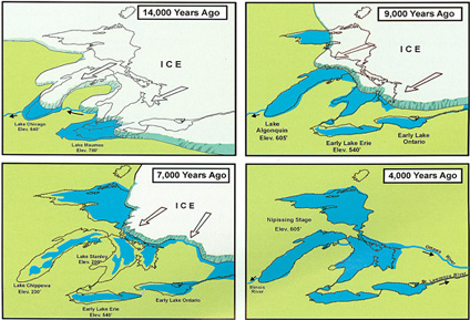
Yes! My sediments exactly.
Do these people expect things to NEVER change?
Hi Kip
Sidel Global has a Carbon Capture Utilization System that we are desperatly trying to get the DOE and EPA to recognize. https://www.youtube.com/watch?v=RQRQ7S92_lo
We transform the CO2 into calcium carbonate and this calcium carbonate can and should be used over the next 30 to 50 years to build sea walls. The White Cliffs of Dover are calcium carbonate. It will stand up to the waves and the surf. It can also be used to regain lost beaches.
If you can help us with a way into Secretaries Pence and Perry, please help us out.
Sid ==> I like the YouTube – very professional. If you have a more in-depth paper on the system — I’d like to read it. If you have a working installation somewhere, I’d like to read the report of results there. My email is my first name at the domain i4 decimal net.
@ur momisugly Sid Abma
I have a few quick questions from watching your video. I hope you do not mind.
1) Your top output stream in calcium carbonate. The only source of calcium is from the plant matter in the input stream. The plant matter is from farm residue, I take it.
a: What percentage of the total CO2 winds up as CaCO3?
b: What is the expected yield of calcium from the farm residue in terms of lbs./acre?
2) The second output stream is biofuel of some description. The farm residue in the process stream is largely cellulose. Can you sketch out the chemical reactions such that cellulose + CO2 == biofuel?
The reaction pathway is not obvious to me.
Thanks in advance.
Hmmmmm….very long on wild claims of a cure to a nonproblem.
Just an observation. The white ciffs of dover are eroding at a furious rate..
Also where do you get the calcium from? what is the total energy cost of processing the calcium and transpoting it to site and then transporting it to wher it will be used??
It’s a solution that is slightly less uneconomical than all the other so called solutions.
It’s also a solution we don’t need since the problem it’s supposed to solve doesn’t exist.
There was a guy who built his house on the southern English coast. He was told that in 50 years it would be gone over the edge. He built it anyway and within 20 years he had to abandon it as it was unsafe. Nature usually wins.
Dubious attribution of the sinking of that delta as due to “sea level rise” caused by AGW is a standard talking point. Compared to the other influences, AGW related seal level rise is tiny. “Other than that, Mrs Lincoln, how was the play?”
Typical of the mainstream media the Times gives the distinct impression that man-made global warming is the primary reason for the threat to Jean Lafitte. Damn the science… full speed ahead.
“prevented land-forming sediments from reaching the delta, and most of those that do are discharged deep into the Gulf of Mexico— the river’s replenishing soil loads are being washed far out into the Gulf”…
..and we were told that all this dirt has very little effect on sea level rise
but one good rain in Australia can make it drop
AFAICS, much of the Mississippi Delta is doomed. Even if sea level rise could be stopped (Good luck with that), the combination of substrate compaction and lack of land replenishment from upstream erosion is going to be lethal. The only salvation I could conceive of would be to pump vast amounts of water (probably salt) into the strata below the region. Frankly I think that would likely turn out to be too costly to contemplate even if it is technically feasible.
Don K ==> Some plans involve letting the river loose at various points to let the silt and soil replenish some of the areas. Look at the full sized map of the levees. The problem is, too many people in places they never should have settled.
There are ongoing river diversion projects south of New Orleans on the Mississippi as well as some dredging projects for land building, but that’s like a straw siphoning water from a firehose. Nature will eventually win. Ain’t enough money to fight it. The Mississippi will eventually destroy or by-pass the Old River Control Structure (see 1973) and reclaim it’s previously meandering way down the Atchafalaya basin.
I recall some biblical proverb against building your home on shifting sands.
Same problem here in West Houston with Hurricane Harvey. We have entire subdivisions built within the dikes of the flood control basin! More are below the grade of the dikes but not physically inside of them. The planning commission for Harris County signed off on these, when any engineer or customer would have said no. Too many people live where they shouldn’t. The solution will be very expensive and disruptive. The people can move or the dam can promise to let water out before it gets full to avoid flooding the people below the grade of the dam. The second action floods the people downstream. Both of these occurred last fall when Harvey dropped several feet of water on us. Since we can’t deepen the outflow channel (Buffalo Bayou), it will have to be widened. Buffalo Bayou flows through some of the most expensive real estate in Houston on its way to the Gulf. It’s a lot cheaper to do the job right the first time, but then someone slips someone some cash, and a building permit gets signed.
“Can Jean Lafitte and the Delta be ultimately saved? Should it be saved?” The answer is No.
The area of the Mississippi delta where Jean Lafitte is located is subsiding at a rate of between 1/4″ to 1/2″ per year. All deltas subside as their sediments compact and dewater under their own weight. It’s a natural process and nothing will stop it.
The National Flood Insurance Program should be re-tooled to take situations like this into account. Home and business owners should be bought out, the buildings and infrastructure should be removed, and nature should be allowed to take its course.
Louis ==> Now, if you read the whole NY Times piece, you’ll see the “wisdom” of the Mayor’s plan — he has conned the various levels of government into investing in all kinds of expensive infrastructure — a stadium, museum, etc — which he hopes they’ll then feel they just HAVE to protect — at any cost. He’s a clever politician.
Here’s an interesting and relevant Power Point presentation on this subject:
https://biotech.law.lsu.edu/climate/docs/2006_october_RDokka.pdf
Louis ==> Great link, thanks.
One thing they can do cheaply is to introduce salt tolerant plants. link
Commie ==> There are plenty of salt water tolerant plants — but the river does not flow through them anymore. That’s the natural progression — salt water tolerant plants catch silt, sand, and soil building into islands and sand bars above the salt — built up enough, the salt is pushed back towards the sea and fresh water/brackish water plants move in, eventually trees etc. This is now happening in reverse….and the salt moves inland, salt march plants supplanting fresh water marsh plants.
I’m suggesting that they get ahead of the process rather than waiting for nature to take its slow uncertain course. One of the first things that jumps out at me is that the feral hogs would probably taste pretty good.
Commie ==> Feral hogs are a bigger menace than even feral cats — both should be eliminated. The cats would be easier than the hogs.
When I lived in Louisiana, the hunting seasons and limits for feral pigs were:
• hunting season, all year daylight hours only
• daily limit, 1 pig
• Possession limit, 1 pig (meaning, to shoot another pig one must eat or give away the entire pig)
Now the hunting season and limits for feral pig are:
• hunting season, all year day or night, though night hunting requires some additional permissions/notifications.
• daily limit, no daily limit
• Possession limit, no limit
It is illegal in most states to sell any portion of a hunted animal or recreational caught fish. All of the states have laws against leaving or throwing away, i.e. wasting, animal carcasses.
Feral pigs quickly become feral hogs; i.e. huge hairy beasts with tusks. One does not eat a 250 to 500 pound hog quickly. Try and give away your pigs frequently and friends and neighbors will avoid you.
Nutria have seasons that are less than all year.
Nutria season is Sept. 1 – Feb. 28, except certain areas have a nutria season Sept. 1 – March 31.
• Daily limit, 5 nutria
• Possession limit, no limit
I know that muskrats are quite tasty. I assume nutria are similarly tasty.
Then, you assume quite a few generalities, commiebob.
• A) The Bayous are not shallow!! Drowning can be easy.
• B) Very few of the islands contain substantial amounts of dirt. Many may only be mats of aquatic plants where some grasses can take hold.
• C) Saltwater intrusion is often storm caused.
• • a) All it takes is a large storm coming from a particular direction to drive a wall of salt water into a mostly fresh brackish water bayou.
• • b) This kills trees that can not handle substantial levels of salt.
• • c) Heavy rainfall and river flow will replace the salt water with brackish water over time, but the dead trees will stand there for many years, especially cypress.
• • d) These stands of trees tend to be close to developed lands where roads or dikes create barriers to natural drainage. Trees that likely would have survived before the dikes/roads were built.
• D) Alligators are common throughout Louisiana bayous!
• E) Even Cajuns raised in the bayous are cautious around salt water alligators!
• F) Below the Intracoastal Shipping Canal, most of the bayous are brackish. The lakes bordering the north side of New Orleans, Metairie and Kenner, Maurepas, Pontchartrain, and Borgne are all brackish water.
Hint, when there is a tidal movement, the water is brackish. Only landlocked bayous are freshwater, e.g. City Park in New Orleans.
Volunteers regularly assist the Louisiana Wildlife Agency with ‘swamp’ projects.
Wearing chest waders, I assisted several times with after Christmas ex-Christmas tree projects.
• A) We’d hammer in posts, then string a fence across an inlet. Then we’d wire ex-Christmas trees to the fence.
• B) The idea was to slow water exiting a bayou, causing silt to drop and fill the bayou.
Gross assumptions couple with armchair ideas that assume Louisianians are blind, ignorant, stupid or any combination is not helpful.
You want to taste wild pigs?
Visit Louisiana, buy the hunting licenses and hunt pigs.
Hint: feral male hogs are frequently quite gamey from their testosterone and hormones. It’s a reason domestic male pigs are neutered early.
Hint 2: raising pigs for meat is easy. There is a sausage called blood sausage, made from the blood of the animal.
1) It is wasteful to just discard a pigs blood.
2) Leaving blood in a carcass promotes gaminess. That “other white meat”? It’s really only white if the blood is drained when the pig is slaughtered.
<a href=http://www.conservationmagazine.org/2013/09/6-invasive-species-recipes/"Wild Boar Herbed Sausage"
http://www.conservationmagazine.org/wp-content/uploads/2013/08/wild-boar-sausage.jpg
Theo ==> Thanks for the cultural input — in Florida, I’ve been told by a relative, landowners can hunt feral hogs anytime, anywhere on their own land — as “nuisance wildlife”.
Sorry. Thanks for the very informative comment.
Kip:
Most states, at least I am not aware of exceptions, allow land owners and farmers to deal with excessive populations or destructive behaviors.
Though most states require an official variance.
e.g. Here in Virginia, farmers apply for permits to reduce damaging animal populations, for example deer. The state sends a local DNR official to take stock of the damage and animal population, then if needed to issue a permit to remove XX deer from the local herd.
Theo ==> For deer, same in NY, farmer can bring in a hunter to do it.
Generally, what happens upstream effects what happens downstream in regards to flooding.
TWC got all excited about the flooding in Cincinnati, the Ohio River recently crested about 20 feet lower than in 1937.
Why wasn’t Jean Lafitte, Louisiana wiped out back then? Or New Orleans, for that matter?
Hmmm…How does the Katrina flooding in NO compare to the flooding in 1937?
(I don’t know. I’m asking.)
Gunga ==> See the flood extent map at Great Flood of 1927
The 1927 Flood affected a vast area of the Mississippi River valley.
Gunga:
The Mississippi River varies in depth. Above Memphis, the river becomes shallower.
From Memphis south to Baton Rouge and New Orleans the river is deep and widens as it descends to the Gulf.
Normally, destructive floods along the upper Mississippi and it’s tributaries are only a concern, not a problem to the lower Mississippi.
Floods along the entire Mississippi River are not common and are very worrying.
That you are just talking is, unfortunately obvious.
The flooding that occurred during Katrina came about when several dikes ruptured as Katrina passed nearby. Ruptures caused by storm surge and winds.
Many areas immediately adjacent to flooded areas did not have any problems.
Gulfport, was flooded by Katrina’s storm surge,
Floods along the Mississippi River, or any river, are not uncommon.
I was in Galveston a number of years ago and happened upon the 1900 The Great Storm Museum on pier 21. The presentation was a telling of the hurricane that struck the city in 1900 and wiped it out causing more than 6000 to 12000 lost lives. After the storm the city rebuilt but included a sea wall that raised the city by 17 feet. The city of Galveston also added fill to bring the level of the city to its present height. With the amount of silt the Army Corp of engineers remove every year from the water ways of the delta instead of dumping it in the gulf it could be used to raise Jean Lafitte. Though this maybe a solution for Jean Lafitte I doubt that with the environs-natzies out there it would never be viable. Like most of the land use doctrine of agenda 21 man is supposed to abandon land to return it to nature rather than Terra-form it to support man.
As rivers slow near the sea they tend to deposit their sediment on the river bed, until the river bed gets to be higher than the flood plain it runs through. As water doesn’t like to move up hill, it then changes course, moving down into the lower flood plain. At times it will chose a new route that reaches the sea far from the original delta. There was one flood in China where a major river chose a new route that reached the sea hundreds of miles to the north. Thousands upon thousands died.
The Mississippi, left to its own devises, would chose a new route and make a new delta over towards Texas. It wants to shift into the channel of the Atchafalaya River, but the Army Corp of Engineers has built an impressive system of power-generating dams to restrict that flow, and keep water heading to the old delta.
The tree-huggers oppose any and all interference with nature, (at least until their own city is threatened). However people have to make a choice: To battle the floods or to move away. The history of the expansion of the English Channel and North Sea after the last ice age involved peoples with a rising sea. It is fascinating to read of their battles. The Frisian people were beaten back in many ways, but the Dutch made fighting the rising sea into an art.
New Orleans needs to decide if they plan to stay and fight, and then perhaps hire some Dutch consultants.
Caleb:
New Orleans made that decision over a century ago.
Most New Orleanians are downright proud that parts of the city are up to 10 feet below sea level.
By the same token, New Orleanians also know which roads not to take home during occasional severe downpours. Some underpasses can fill with many feet of water.
Most of the New Orleans areas that are sinking are areas of fill.
Fill, that occurred long before people figured out that fill with high levels of decomposing matter continually lose that volume.
The oldest portions of the city, e.g. French Quarter, are built upon original land forms; many of which contain middens. These areas are not sinking anywhere near as fast as areas built upon swamp bottom and trash fill.
Nothing but disdain for southerners from the bleeding hearts…unless they can be used as a poster child for political gain.
Just like how Native Americans are all but ignored by the same unless there’s an oil pipeline to protest.
this screwing around with Nature and the crappy results are not any different than the Gov’t fucking with the Economy as much as it does… there are consequences for all actions… then there is the Chaos Theory, ” A very small change may make the system behave completely differently. ” Further explanation can be found in Jurassic Park- M Crichton … but I don’t have to tell ya’ll
Kip,
Just did a quick read — very busy today.
Did you mention the depth of the sediments near NO?
I think I recall seeing it is about 50,000 feet.
20-25 years ago, NOVA or ?, had a good video about this.
I do not know if those are available on the web
John, you are correct. The sediment thickness in the area of New Orleans is estimated to be approximately 15 km (or 50,000′) thick.
John ==> The Nova episode (#16 with Burt Lancaster) is here. One can buy a view from Amazon.
I keep thinking about all the farmers upstream that do everything they can to keep their fields from getting washed away.
For the most part they’re not being washed away – they’re being flooded like in the old days, which is good for farmland but not for the permanent structures palced there.
scraft1 ==> Depends on where you are — the Gulf side of everything has been washed away, in many cases, whole islands have disappeared. Banks of canals get eroded and canals widen.
The farmers upstream though, get their fields replenished, but sometimes by nothing but sand.
Not quite Kip.
Outside of tidal movement, there is very little water movement. With a typically small tidal change; e.g. Jefferson Parish’s tides for Jean Lafitte have a water hight total change of 0.41m (16.14 inches).
The current in the Mississippi River is swift enough to wash away stuff, but the river is channeled from well above New Orleans until the river exits into the Gulf of Mexico.
Decomposing vegetable matter eventually lowers islands until the grasses and reeds drown, or the floating plants (hollow stems) float off with the tide.
One can find rafts of these floating plants out in the Gulf.
Storms can and do exacerbate this loss, but the action is more similar to shaking a glass of muddy water. When it settles, lumps tend to be flattened.
Most of the bayous along the Gulf coast are brackish and salt water bayous. Except when planting salt loving plants, flooding does not improve farmland.
Theo ==> I think we’ve got two subject conflated here. The farming bit refers to upriver flooding.
The historical map shows where the River delta has been washed away.
Canal bank erosion is a long-term problem, see the animation linked in the essay.
Perhaps.
The Mississippi River is long and involves major tributaries over a substantial portion of the USA.
General discussions lose precision and accuracy when discussing specific river sections.
I am at a loss to know which map you consider historical. But the term “washed away” is still incorrect.
As decomposing matter degrades and is consumed, the land sinks. It is true for portions of New Orleans and surrounding areas, and it is true for the swamps bereft of fresh sediment.
Without fresh deposits, the land submerges. Plants on top expire or float away.
It isn’t erosion, it is loss of material! It is subsidence.
The Canal bank erosion animation is cool looking, but not accurate.
Such an assumption would mean that the banks erode bit by bit over years. Which takes substantial water movement.
Bayous do not have substantial water movement. It is one of the reasons bayous are called bayous, swamps are named swamps and rivers are rivers; water movement!
Artificial canals could erode, except that dredging spoils are used to refresh banks and dikes regularly.
Because a large majority of those canals were cut through the swamps for specific reasons, many of which still exist; e.g. maintenance.
Dikes that keep in salt water as well as allow passageways through the swamps. i.e. when a storm surge or wind blown tides push slugs of salt water over a low dike, it is retained and kills the low salt tolerant plants.
New canals cut through the delta allowed salt water influx; but the majority of the bayous and swamps under discussion were brackish to some level. It takes a continuous flow of fresh water to keep portions of coastal swamps, fresh water.
When one passes stands of dead trees in Barataria, one can stop and inquire of locals. Many of the locals know the history.
The erosion story fails to explain why there are stands of dead trees between stands of live trees. Or why the stands of dead trees are few in number while the stands of live trees are extensive.
It is a 76 mile drive from New Orleans to Venice, LA. With trees common along the route.
Though, if one wants to see dead stands of trees, drive through Chalmette, LA towards Delacroix, LA. Where the canals are cut, south of Meraux are where one sees the most stands of dead trees. Down near Delacroix, where few canals are cut, trees are alive and healthy.
I kept a boat in Delacroix, and tried to fish in many other areas right down to and including the Gulf of Mexico. Occasional stands of dead trees puzzled me, so I asked, locally.
You include a link to American Museum of Natural History. AMNH presents a picture allegedly of “dead water” showing a clear divide.
As one who has fished in the Gulf of Mexico around New Orleans, it is very easy to see where green water, dirty river water and the Gulf’s beautiful blue water meet on the surface.
Though, normally one only sees green water meeting blue water, as the river’s fresh water tends to flow under the green water as it exits the river’s various passes.
It is also normal for border waters to have debris lines. Fisherpeople search for both water borders and debris lines as either are indications of fish holding water. It’s a jackpot to find both together as pelagic species feast on foods brought by the green or dirty water.
In other words, I’d need to see sensor readings before I believe someone’s picture.
That dirty water hugs along the coast well into Mississippi and part of Alabama. Which is why Gulfport purchases sand to create a sandy beach where people can swim.
The Chandeleur Islands are best described at sand dune pinnacles barely breaking the water’s surfaces. Most of the Chandeleurs are greatly reduced in size versus what is pictured. Plus, the Chandeleurs have moved, sometimes substantially.
https://www.dropbox.com/s/2li60s01ufr8efa/Chandeleur%20Islands.geprint?dl=0
No, I am not harassing you Kip. I greatly respect your article and summaries.
I lived in New Orleans for a number of years and loved the people, city, surrounds, swamps and fishing.
Keep in mind, that it takes water movement to erode land. The river water is channeled, often between rock barriers and does not affect swamps and bayous. The tidal movement is small, e.g. 16 inches height differences between high and low tides. Neither the swamps or bayous have sufficient water movement to erode land, especially plant overgrown land.
Theo => Erosion of canal banks is a major issue — at least according to the USGA — storms from the Gulf provide the water movement to eat away at the land, as you can see in the 6,000 year historical map.
I do not mean “washed away by the passing of the river water”, which I think is what you are saying isn’t so — and I agree on that — with the odd caveat that the soil that should be building the delta is flowing far out into the Gulf.
USGA?
No idea.
Did you intend USGS?
Kip, you do really good research and write excellent articles; but, in this case you are reliant upon other sources entirely and getting led astray.
A) The government agency that is responsible for and handles everything about the Mississippi River and Mississippi River Delta is the Army Corps of Engineers.
– i) Not USGS, Not NOAA, Not NASA
– ii) USGS used to be reliable, until they got orders to recognize anthropogenic climate change and that fracking causes quakes. Unfortunately, USGS is far down the list of agencies getting fixed soon.
B) The Mississippi River is bounded by dikes and levees.
– i) All dikes and levees get regular maintenance; i.e. when the Army Corps dredge channels, the dredge spoils are used to repair dikes and levees.
– ii) Substantial portions of the lower Mississippi River are bounded by rock levees. They ain’t eroding!
– iii) http://www.usace.army.mil/Portals/2/docs/recovery/MRTApr10RIOOMBupdatedv1.pdf, http://www.usace.army.mil/Portals/2/docs/civilworks/annual_report/fy07/MVD_fy07.pdf
C) Canals are cut for purpose.
– i) Canals that are still utilized get repaired via dredge spoils. Regularly.
– – a) This is the case whether the canals are for drainage or rig/well maintenance or resupply. – – b) Much of New Orleans, Metairie, Kenner, La Place, West Bank, Barataria are crisscrossed with drainage canals.
– – c) Water runoff drains into a canal, somewhere along that canal there are massive pumps that pump runoff into canals connected to sea level water exits; e.g. Lake Pontchartrain, Lake Borgne, Intracoastal Canal, etc.
– ii) Unused canals are slowly reverting to swamp land. I emphasize slowly.
D) As pointed out upthread, boat traffic is a problem for canal banks.
– i) Waves caused by boats travelling too fast slap the canal banks just as breakers slap a beach.
– ii) That causes banks to slump and fill channels
– iii) Or it causes gaps where high waters can flow out of the canal.
– iiii) If it’s an in use canal, it will still get repaired.
– l) Where somebody might have assumed storms cause canal bank erosion would be from the canal bank failure caused by a combination of hurricane Katrina’s storm surge, hurricane winds, and a long storm reach over Lake Pontchartrain that piled water into a drainage canal that bordered New Orleans and Metairie.
– ll) The section that failed had just undergone a multi-year improvement by the Army Corps of Engineers; including driving steel I-beams deep as support. Only the sheer height and weight of water pushed the canal bank, beams and wall into the local residential area.
– m) There was another bank ‘failure’; i.e. the Intracoastal Canal bank was overtopped by high waters that flooded another New Orleans District.
– mm After overtopping the bank, the water eroded a larger exit.
Unless, someone is actually out in the swamps following canals, channels, bayous, researching, talking to residents/fisherpersons/shrimpers verifying and validating findings they are ignorant of the situation!
It is not in USGS, NOAA, NASA remits and authorizations to go researching Mississippi River Delta. The Army Corps of Engineers is rather intolerant of fiefdom intrusions.
“I do not mean “washed away by the passing of the river water”, which I think is what you are saying isn’t so”
I did not use those words, Kip. Nor is your interpretation anywhere close.
Rapid erosion is caused by water movement. Period.
i) Water in the swamps or bayous is moved by inflowing river water; which the River dikes prevent. Too slow for erosion.
ii) Water is moved by tidal movement.! Only tidal movement in the Gulf of Mexico is minimal; maybe a maximum of 2 feet total over 12 hours and usually much less. Too little movement and too slow for erosion.
iii) Wind might cause some water movement. But this requires a constant wind from one direction for long periods of time. This rarely happens. Rare events where there is some erosion.
If a storm is large enough to cause a significant storm surge, then a storm will cause water movement. New Orleans and the Mississippi Delta, like so many other places go years without serious hurricane strikes.
Even if the New Orleans had several hurricanes every year, they are unable to cause significant water movement.
Except for the river and a few canals, all Mississippi Delta water must traverse crisscrossed bayou mazes. No sane fisherperson goes fishing in the Mississippi River bayous without a detailed map; and the latest satellite imagery was very popular. A longtime resident who traversed many bayous every day might be all right without a map, but they’re taking risks.
It is not hard at all to get lost in the bayous. Those islands that recently sank are just below the surface.
What looks like any other bayou water traps boaters. My buddy and I got caught following a map when we came to a large open water area that was supposed to be bayous and islands. He started circling while I tried to find where on the map we were.
We got stuck, and it was my turn to get in the water to clear the motor intake and try to push the boat off; all while wondering when my a$$ would get bit by a gator.
We exited the open area, where we came in and followed another route. The open water was too dangerous to try and cross.
New Orleans is 76 miles from Venice, LA. Venice is a substantial distance yet from the Gulf Of Mexico. Essentially, there are dozens of miles of swamp, bayous and islands that hinder and slow any storm surge.
Every day, the Mississippi Delta loses land. Every day, week, month and year, land is lost and the total cumulation of lost land is staggering.
I repeat.
Mississippi Delta land is lost through subsidence!
Just as, and for the exact same reasons, the land is sinking in New Orleans, it is sinking throughout the delta.
When land subsides below water, surface plants are killed, or they float away.
Yes, everyone agrees that the Mississippi river is channeling silt out into the Gulf of Mexico; and that is the actual cause of Mississippi Delta loss.
Only, no one is willing to remove all Mississippi River dikes and levees below New Orleans.
Mississippi River water would normally filter through the swamps, where slowed by the masses of swamp water, convoluted paths and islands, sediment drops from the water column or is caught by roots and plant growth.
When floods would bring larger masses of water coupled with a heavy silt load, the entire Mississippi River Delta would benefit. Muddy water that enters the swamp eventually exits into the Gulf of Mexico rather clean looking.
The moment someone starts claiming canal erosion by storms, kick em!
Theo ==> well, at least you’re stickin’ to one story.
Everyone seems to agree that it is the the channelization of the River that is the ultimate cause of land loss.
No time for long reply until home, but good stuff out there regarding the south Louisiana loss of land, and it is likely mostly due to man! Not climate change or even a few storms.
Born and raised in NOLA and even in the early 50’s the changes were evident and the land was sinking. So go back and look at:
– levee construction since 1927
– the Old River diversion project
– thousands of miles of canals dug for petroleum exploitation
– the MRGO project in more recent times
and I could on, but have to drive home manana and there’s no lack of info about the loss of wetlands down there and plenty of orgs associated with it. So start with LSU and then just surf.
Gums…
P.S. My classmate in Jean Laffite came thru Katrina just fine and our class had its reunion crawfish boil there in 2010. NOLA flooding was mostly bad engineering and a big storm.
Bad engineering indeed, if this area is worth saving perhaps the Dutch engineers should be invited to participate. These areas are sediment, protected and drained properly you can grow anything.
Kip,
It would appear that you are deliberately mis-stating what the article states. Every contributor to land
loss that you mention is mentioned in the article. Climate change is only every listed as one of the causes.
The article states that:
“Rapid subsidence and associated wetland loss were largely induced by extraction of hydrocarbons,” concluded a 2005 study of the Mississippi Delta plain by the Geological Survey.
or
Scientists and conservationists have sounded alarms since the 1920s about the loss of land
to oil exploration.
or
the land sinks, canals widen and sea levels rise because of climate change.
which I at least understand to mean that only sea level rises due to climate change. And again note
the qualifier “As climate change contributes to rising sea levels”. So the article is not stating that
climate change is the only cause of rising sea level as you would appear to believe.
Geronimo ==> I helps if you read the whole essay — this is your last reply from me as long as you continue to troll.
I’d be happy to answer you serious on topic questions.
Kip,
Again you state that
“So what’s the real deal here in the Mississippi Delta? The USGS and NOAA both tell us the land is sinking — this is subsidence caused by the pumping of petroleum (and water) out from under the Delta and compaction of the sediments that make up the land.”
How is this different from the statement in the article that
More recent research links the industry to subsidence — the compaction and sinking of sediment. “Rapid subsidence and associated wetland loss were largely induced by extraction of hydrocarbons,” concluded a 2005 study of the Mississippi Delta plain by the Geological Survey.
You appear to ignore the bits of the NY Times article that disagree with your narrative that the only
thing that they discuss are climate change. In fact the article discusses all of the reasons for land loss
from engineering to oil and gas extraction and climate change.
The article mentions all the factors but you’re left with the impression that rising sea levels due to climate change is the one common trait to all coastal problems worldwide – when in fact sea level rise is at the same historical rate and thus erosion woes have virtually nothing to do with climate change.
Most people will read the first few paragraphs of the article and look at the picture of the land sinking under the misery caused by human stupidity. The overwhelming message is that absolute sea level rise is the culprit.
Kip, have you seen this information previously? The nola.com article is based on a paper/poster presented at the 2017 AGU meeting in NO about the upriver silt buildup and potential for the Mississippi River to return to the Atchafalaya River basin. I wandered through Louisiana in 2016, stopping in a number of museums and historical parks. I think it was at one of the Jean Lafitte NHP locations (but I can’t recall which one) where a display implied it is just a matter of time before the Mississippi deserted its present channel and took a more direct route south along the Atchafalaya.
http://www.nola.com/environment/index.ssf/2017/12/rising_river_bottom_could_swit.html
Windsong ==> Yes, a close look at the Mississippi Watershed image shows how very close the Mississippi and the Atchafalaya channels come to one another and the human efforts to force the issue. All part of the problem.
Windsong:
You are more correct than one likes.
Right now, the Army Corps of Engineers are very proud that their chaining the Mississippi to it’s current exit to the Gulf of Mexico is successful.
And they celebrate every time a near disaster passes close.
A major flood event throughout the upper Mississippi River strains the flood control system at at Atchafalaya.
When both the upper river and the lower river systems are seriously flooded, the Engineers divert water from the MIssissippi through the Atchafalaya basin. Each time, the Engineers worry that water will wash out some critical component with the resulting flood then carves a new Mississippi River channel to the Gulf. Much like the dam failure in California, but much bigger.
The truth of the matter is that it is not natural for a river to only flow in one channel forever.
Using Google Earth, one can locate oxbows along the Mississippi River and along many other large rivers. Oxbows are one result when a river cuts a new channel.
It is also the Army Corps of Engineers responsibility to dredge excess silt out of the river.
“the Mississippi Delta is washing way.”
Common Yankee error:
The Mississippi Delta is not to be confused with the Mississippi River Delta.
“The Mississippi Delta, also known as the Yazoo-Mississippi Delta, is the distinctive northwest section of the U.S. state of Mississippi (and small portions of Arkansas and Louisiana) which lies between the Mississippi and Yazoo Rivers.”
https://en.wikipedia.org/wiki/Mississippi_Delta
Walter ==> Well, interesting point of local knowledge.
Let all readers know that in this essay we are discussing the Mississippi River Delta, as shown in the maps and charts, and not some other place that really isn’t a delta, but rather an alluvial floodplain. Do see Walter’s Link or this for more than you ever wanted to know about the different things called the Mississippi delta.
We owe the Mississippi Delta special reverence because it is the birthplace of the blues.
“… [R]ead John McPhee’s “Atchafalaya.” https://www.newyorker.com/magazine/1987/02/23/atchafalaya It was published in February, 1987, and it’s about the Herculean effort of the U.S. Army Corps of Engineers to control the flow of the Mississippi River, the fourth-longest river in the world. “Atchafalaya” is the name of the “distributary waterscape” that threatens to capture and redirect the flow of the Mississippi. If that happens, the cities and industrial centers of Southern Louisiana could find themselves sitting, uselessly, next to a “tidal creek,” and economic ruin would be the inevitable result. To prevent that, the Corps of Engineers embarks on a vast project to artificially freeze the naturally shifting landscape. McPhee meets the engineers and explores the structures they’ve built to “preserve 1950 … in perpetuity.”
* * *
In 1989, McPhee incorporated “Atchafalaya” into a book called “The Control of Nature.” http://www.amazon.com/dp/0374522596/ (He’d been passing by the engineering building at the University of Wyoming, and had been struck by its inscription: “STRIVE ON—THE CONTROL OF NATURE IS WON, NOT GIVEN.”) Like the Mississippi, “Atchafalaya” is long—around twenty-seven thousand words. But it’s all available online, and it gives you a real sense of what it’s like not just to live and work beside one of the world’s great rivers but actually to struggle with it.”
https://www.newyorker.com/books/page-turner/letter-from-the-archive-john-mcphee-on-the-control-of-nature
Walter ==> Thanks for the link.
The Mississippi River Problem is complex and mufti-faceted. Solutions will be complex and expensive. i would urge one and all to start with the John McPhee essay I linked above.
The Mississippi River should be allowed to go where it wants to go: the watercourse of the Atchafalaya river. The river should be replaced as a transportation artery by canals — big ones at that from Cape Girardeau south. The canal system should allow river traffic to be trans-shipped to ocean ships at Mobile Bay which is a superior natural harbor.
None of this can happen until the last lawyer is strangled with the entrails of the last environmentalist.
When the Corps of Engineers built the main stem dams on the Mississippi and Missouri, and the locks below, they effectively stopped the deposit of soil in the delta region. Now the reservoirs are silting in and things will only get worse. IIRC, Lake Sakakwea (the reservoir in North Dakota) was predicted to be usable for 600 years. Not going to happen. Downstream from Pierre,SD, the pass-thru lakes are becoming very silted. Mother Nature will prevail.
“Mother Nature will prevail.”
Amen.
An article from Sept 2005, but still on target
https://pesn.com/archive/2005/09/23/9600175_Rebuild_Energy_Systems_Not_NewOrleans/index.html
And near the end, a pragmatic recommendation to accept defeat. New Orleans and surroundings have been sinking for the past several thousand years. There are better things to spend trillions on, than to reverse the inexorable course of nature.
One item that no one else wants to talk about, but I will. Once you put an entire sinking city at/below sea level, with over 1/3rd of a million inhabitants behind a 14-foot seawall, it becomes a very tempting terrorist target. A couple of airplanes or explosive-laden trucks flown/driven by suicidal terrorists, breaching the sea wall at strategic locations in the middle of a storm (let alone a hurricane) will cause major flooding if not loss of life. Every anti-American nutcase will be targetting it. Don’t do it.
Kip,
Great story. Thanks. BTW, where did you get that fine diagram of Mississippi watershed? I want to have one.
BLE
In a sufficiently complex system any attempt to change it will almost certainly result in unintended consequences.
Life is hard, isn’t it?
During the 1980s I often attended Gulf States Marine Fisheries Commission meetings. During much of the 1990s I was one of our states representatives on the commission. Reading this essay is deja vu all over again. Once a year the Corps of Army Engineers give us a detailed briefing on the Mississippi Delta. While they mentioned the possibility of rising sea level due to global warming they were quite clear about the problems the Delta and the communities, especially New Orleans faced. Basically the Mississippi was dike and the mouth controlled for shipping, not just oil and gas. The sediment that once came down the Mississippi and made the Delta now flows well offshore, sinks and creates an oxygen zero area on the bottom of the Gulf. It has gotten worse over time as the Delta has continued to subside. Remember the massive flood in 1993 when many of the dikes failed upstream.
Edwin ==> Thanks for the personal touch.
I blame the Mississippi River delta issues on the US Corps of Unintentional Consequences.